• Home
  • ⭐ Travel Guide for Island Crete ⛵, Greece❗ - Φαγητό
  • 10 top attractions of Chania City

    Chania is considered for many Greeks the most beautiful city in Greece, a designation that seems quite true when visiting this place. Great samples of architecture of previous centuries, despite the changes throughout time, still maintain most of their original glory. Here we present some of the sights you can see in the city of Chania and within a short distance.

  • 10 Top attractions of Heraklion City

    Heraklionhas a great history and, although its character has altered tremendously due to the catastrophic interventions of the past century, there are places that remind something from the beautiful Grand Castle of the Mediterranean. Here we present ten top attractions.

  • 10 αξιοθέατα που πρέπει να επισκεφτείτε στα Χανιά

    Τα Χανιάαποτελούν για πολλούς την ομορφότερη πόλη της Ελλάδας, ένας χαρακτηρισμός που δεν της έχει αποδοθεί καθόλου τυχαία. Εξαιρετικά δείγματα αρχιτεκτονικής των προηγούμενων αιώνων, παρά τις αλλοιώσεις που έχουν υποστεί κατά καιρούς, διατηρούν σε πολύ μεγάλο βαθμό την αρχική τους αίγλη. Εδώ σας παρουσιάζουμε μερικά από τα αξιοθέατα που μπορείτε να δείτε στην πόλη των Χανίων αλλά και σε κοντινή απόσταση.

  • 25th August Street

    The most historical and beautiful street in Heraklion is (and always was) the street with the beautiful neoclassical buildings, the Venetian Loggia, and the church of Agios Titos, connecting the Venetian harbor to the Square of Lions. This is the 25th of August Street.

    During the Venetian Era, it was called Rouga Maistra, while the Turks later called it Vezir Tsartsi. However, a very interesting name that was later used was Plani’s Street (i.e. Delusion Street) because of the beautiful neoclassical buildings that gave visitors a false picture of Heraklion which, besides this street, was full of poor and dirty neighborhoods.

    The current name comes from the tragic events that occurred here on August 25, 1898, on the feast day of Saint Titus, when the Turks massacred hundreds of Christians Cretans, 17 British soldiers, and the vice-consul of England, Lysimachus Kalokerinos, while all the houses and shops were destroyed. The reason was the handing of the management of the toll office of Heraklion to a Christian official, which was a term for a new autonomous Cretan State, under the supervision of English troops. This tragedy forced England, Russia and France to accept the Cretans’ request for the abandonment of the Turkish army from Crete.

    [widgetkit id=2168]

    Find nearby hotels

    {loadposition nearestplaces}

  • Abandoned Settlements

    Crete is dispersed with settlements that were once abandoned because of urbanization or for some other reason, such vendettas, natural disasters, etc. Even today the walls of houses testify that life once existed there. It is interesting to refer to some of them.

  • Accommodation

    In Crete, tourism remains the main driver of economic growth, meeting all modern requirements of high quality services. High quality lodging services in exceptionally landscaped sites, private marinas, swimming pools, fitness centers, conference centers, spas, restaurants with unprecedented flavors and experienced staff, meet the needs of the most demanding guests.

  • Agia Galini Stadt

    Agia Galini ist ein beliebter Badeort, der 61 km südöstlich von Rethymno und 68 km südwestlich von Iraklion liegt, am südlichen Ufer des Tals von Amari. Der Name von Agia Galini bedeutet heilige Tranquility oder heilige Serenity im Griechischen, was bedeutet, dass dieser Ort sehr friedlich ist und das Meer immer ruhig ist. Die hervorragenden Kiesstrände, der malerische Hafen und das traditionelle Dorf locken jedes Jahr Tausende von Touristen an. Als eine große touristische Entwicklung traf, war das Dorf ein kleines Fischerdorf, das tatsächlich den Bewohnern des benachbarten Melabes Dorfes diente. Aber später, in den 60er Jahren, wurde Agia Galini ein beliebtes Ziel für die befreiten Blumen Kinder, die Hippies. In der Tat gibt es noch viele Fans der Gegend, die jedes Jahr das Dorf besuchen.

    Heute ist Agia Galini ein modernes Resort mit traditionellem Charakter, das allen Gästen alle Annehmlichkeiten bietet. Sie hat viele Möglichkeiten für Unterkunft, Verpflegung, Unterhaltung, medizinische Dienstleistungen, Post, Banken, Geschäfte etc. Agia Galini liegt auf den Hängen eines hohen Berges, in der Nähe der Mündung des Flusses Platys oder Amarianos, der aus dem Dorf Thronos beginnt und das ganze Jahr über Wasser hat. Die Häuser des Dorfes sind mit Blick auf die riesige Messara Bucht und das endlose libysche Meer.

    Der südliche Stadtrand von Psiloritis steigt ein paar Kilometer nördlich des Dorfes, umgeben von wilden und imposanten Klippen und mit mehreren traditionellen Dörfern, die über ihnen hängen. Westlich von Agia Galini, entlang der Küste, werden viele schöne schroffe Höhlen geformt, die man nur mit dem Tourboot besichtigen kann. Eine von ihnen heisst die Höhle von Daedalus, weil sie die Werkstatt des legendären Handwerkers und Künstlers Daedalus war. Boote laufen auch vom Hafen zu den nahe gelegenen Stränden wie St. George, St. Paul und Preveli. Gegenüber von Agia Galini gibt es die beiden Inseln von Paximadia, die mit dem Tourboot erreicht werden können. Außerdem gibt es einen unbekannten Strand mit Kieselsteinen auf einer von ihnen.

    Agia Galini wurde auf dem Gelände des alten minoischen Hafens von Syvritos (heute Thronos Dorf) gebaut, das Soulia genannt wurde. Archäologische Ausgrabungen in der Gegend haben mehrere Erkenntnisse aufgedeckt. Reste von Säulen und ein Tempel, der der Göttin Artemis gewidmet wurde, wurde in der Nähe des Flusses gefunden. Die Archäologen haben ein römisches Schiffswrack des 3. Jh. Jahrhunderts entdeckt. Figuren, Lampen, Statuen, Bronzegegenstände wurden auch gefunden und werden derzeit im Archäologischen Museum der Stadt Rethymnon ausgestellt. Soulia wurde von den Sarazenen im Jahre 640 n. Chr. zerstört. Als die Griechen Christen wurden, bauten sie das Kloster des heiligen Christus (Galinios Christos) auf den Ruinen des Tempels von Artemis. Sie können noch auf dem Friedhof, direkt vor dem Dorf, die Kirche des Klosters sehen, die der Jungfrau Maria gewidmet wird. Schließlich, neben dem westlichen Ende des Hafens, gibt es einen hohen Felsen. Nach der Mythologie begannen Daedalus und Ikarus ihre Flucht von diesem Punkt, um von König Minos zu entkommen. Sie können das Denkmal auf dem Felsen, mit zwei modernen Statuen der ersten Flieger in der Mythologie, besuchen.

    Mehrere Versionen wurden über den Ursprung des komischen Namens von Agia Galini (d.h. Heilige Ruhe) gehört. Eine von ihnen sagt, dass, als eine byzantinische Prinzessin nach Jerusalem reiste, ihr Schiff in einen großen Sturm fiel. Sie fing an, zu Maria zu beten, um Hilfe zu bitten und schwor, einen Tempel zu bauen, der ihr gewidmet werden wird. Tatsächlich gelang es dem Schiff, sich dem Gebiet zu nähern und in der geschützten Bucht des Dorfes zu verankern. Die treue Prinzessin baute einen Tempel und nannte ihn Panagia Galinia, die später zu Agia Galini paraphrasiert wurde. Diese Kirche ist die alte Kirche auf dem Friedhof. Darüber hinaus kann der Name vom Griechischen galini abgeleitet werden, was "immer" ruhig" bedeutet. Agia Galini kann mit dem Bus von Heraklion, über Tymbaki erreicht werden.

    Zusätzlich gibt es Busse, die von Rethymnon über Spili laufen. Wenn Sie mit dem privaten Auto kommen, schätzen Sie, dass Sie 1 Stunde von Rethymnon und 1: 30hr von Heraklion benötigen.

    [widgetkit id=1346]

    hotels booking Crete

    {loadposition nearestplaces}

  • Agia Galini Town

    Agia Galini is a popular seaside resort, located 61km southeast of Rethymnoand 68km southwest of Iraklion, on the southern shores of Amari. The name of Agia Galini means “Holy Tranquility” or “Holy Serenity” in Greek, implying that this place is very peaceful and the sea is always calm. The excellent pebbly beaches, the picturesque harbor and the traditional village attract thousands of tourists every year. Before the ‘60s and ‘70s, when it met a large tourism development, the village was a small fishing village that actually served the residents of the neighboring Melabes village. But later, in '60s, Agia Galini became a favorite destination for the liberated flower children, the hippies. Indeed, there are still many fans of the area, who visit the village every year since then.

    Today Agia Galini is a modern resort, with a traditional character, which offers all amenities to its visitors. You will have many options for accommodation, food, entertainment, medical services, post office, banks, shops etc. Agia Galini is built on the slopes of a high mountain, near the mouth of the River Platys or Amarianos, which starts from the village Thronos and has water all year round. The houses of the village are overlooking the vast Messara bay and the South Cretan Sea.

    The southern outskirts of Psiloritis rise a few kilometers northern of the village, surrounded by wild and imposing cliffs and with several traditional villages hanging over them. West of Agia Galini, along the coastline, many beautiful rugged caves are shaped, which you can visit only by tour boat. One of them is called the Cave of Daedalus, because they say that it was the workshop of the legendary craftsman and artist Daedalus. Boats also run from the harbor to the nearby beaches such as Agios Georgios, Agios Pavlos and Preveli. Opposite of Agia Galini, there are the two islets of Paximadia(i.e. Nuts), which can be reached by tour boat. Moreover, there is an unknown beach with pebbles on one of them.

    Agia Galini is built on the site of the ancient Minoan harbor of Syvritos(today’s Thronos village), which was called Soulia. Archaeological excavations in the area have revealed several findings. Remains of columns and a temple, which was dedicated to the goddess Artemis, have been found near the river. Also, archaeologists have discovered a Roman ship wreck of the 3rd AD century. Figurines, lamps, statues, bronze objects have been found in it and are currently exhibited at the Archaeological Museum of Rethymnon city. Soulia was destroyed by the Saracens in 640 AD. When the Greeks became Christians, they built the Monastery of Serene Christ (Galinios Christos) on the ruins of the temple of Artemis. You still can see in the cemetery, just outside the village, the church of the monastery, now dedicated to Virgin Mary (Panagia). Lastly, next to the west end of the harbor, there’s a tall rock. According to mythology, Daedalus and Icarus and Icarus started their flight from that point, in order to escape from king Minos. You can visit the monument on the rock, with two modern statues of the first airmen in mythology.

    Several versions have been heard on the origin of the weird name of Agia Galini (i.e. Holy Tranquility). One of them states that when a Byzantine princess traveled to the Jerusalem, her ship fell into a big storm. She started praying to Mary, begging for help, and vowed to build a temple dedicated to her. Indeed, the ship managed to approach the area and to anchor in the sheltered bay of the village, that is never wavy. The faithful princess built a temple and named it “Panagia Galini”, i.e. Virgin Mary of Serenity, which was later paraphrased to Agia Galini. This church is the old church in the cemetery. Moreover, the name can be derived from the greek words “aei galini", meaning “always calm". Agia Galini can be accessed by bus from Heraklion, via Tymbaki. Additionally, there are buses running from Rethymnon, via Spili. If you come by private car, estimate that you need 1 hour from Rethymnonand 1:15 hours from Heraklion.

    [widgetkit id=1346]

    hotels booking Crete

    {loadposition nearestplaces}

  • Agia Roumeli

    Agia Roumeli is a small secluded village, located 56km south of Chania city, on a wide bay shaped at the exit of the Samaria Gorge. Thousands of visitors, descending the gorge, reach this place every day. Agia Roumeli is a calm place in the wild and mountainous landscape of Sfakia province. The only way to reach the village is either through the gorge or by getting the ferry from Chora Sfakia, Loutro, Paleochoraand Sougia. The more adventurous (and lucky) visitors could walk the path from Chora Sfakia to St. Roumeli (7 hours). The picturesque village of Agia Roumeli provides all basic amenities, such as taverns with traditional food, rooms for accommodation, cafes, mini market, internet access and telephone.

    Daily, between 13:00 to 16:00, the village and its beachesare swamped by visitors of the gorge. However, after the departure of the ferries, the village gets very calm! If you choose not to follow the crowd with the ferry, but to stay in the village for at least one night, then you will have the opportunity to admire this beautiful place with its unique people, good food and stunning natural beauty.

    The Samaria Gorge is the longest gorge in Europe, having a length of 18km. During the summer, it is visited by thousands of tourists who trek 18km in about 6 hours. Many of them have visited Crete just to cross the majestic gorge of Samaria. If you do not have the time to walk all the distance in the gorge, you can walk backward, starting from Agia Roumeli.

    Agia Roumeli is built on the ruins of ancient Tara. Tara was built by the Romans. To the west of the village, there are still ruins of the Temple of Apollo (or Artemis). Today, at this point you can visit the old church of Panagia (Virgin Mary) built in 1500.

    On the hill above the village, there is a ruined Turkish castle (Kule), from where the view to the village, the vast Libyan Sea, Gavdos and Gavdopoula islands is fantastic. Walking the easy path to the castle takes 30’-60’. From the castle, if you continue walking on the steeper slopes of the mountain for 90’ more minutes, you will reach the ruins of a second castle.

    On the eastern edge of the gorge, near its exit, you can visit the beautiful church of St. Anthony. The chapel is built in a cavity, shaped in rocky walls.

    Approximately 2km north of the village, inside the gorge, there is the old village of Agia Roumeli, in a lush green landscape. There you will see ruins of old houses and some homes restored by their owners. The village was abandoned in 1954, when it was completely destroyed by floods. Then, the village was moved to its present position, in Agia Roumeli.

    Even people and food in Agia Roumeli constitute attractions! The people are genuine Cretans, with pure heart and real smile. The meat you will eat in their restaurants is bred by them. They also are the producers of cheese, vegetables and honey they provide in tavernas. Fortunately, despite the development of tourism, Agia Roumeli has remained authentic and picturesque, where you can meet friendly people, enjoy high-quality traditional recipes and the tranquility of nature.

    [widgetkit id=86]

  • Agios Dikeos range

    Mount Agios Dikaios or Ai Dikios rises south of the village Elos and at an altitude of 1180m it is the highest peak of Kissamos province. At the top of it is the church of Saint Dikeos. The church was erected in 1870 in honor of Job the righteous(celebr. May 6th - dikeos means righteous). At this point, which has a panoramic view of the provinces Selino and Kissamos, a German post was installed during the German Occupation of Crete in the Second World War.

    The peak can be accessed through a dirt road from Elos, however there is also a signposted trail that starts from Elos, reaches Agios Dikeos peak (1180m), continues south to Tsounara peak (1101m) and descends to the village Moustakos. Initially the vegetation consists of chestnut trees and as it ascends it gives way to shrublands.

    [widgetkit id=2343]

  • Agios Nikolaos

    Weiß gewaschene Häuser und schöne Gebäude in Agios Nikolaos haben das Meer als Hintergrund.

    Die schöne heitere kleine Stadt Agios Nikolaos ist die kosmopolitische Hauptstadt der Präfektur Lasithi mit 20000 ständigen Einwohnern. Die Stadt wurde auf dem Gelände Mandraki, auf der Westseite des Golfs von Mirabello gebaut, aber der heutige Name stammt aus der byzantinischen Kirche St. Nikolaos westlich der Stadt.

    Hier war der Ort der Minoischen "Lato Pros Kamara", der Seehafen der Stadt Lato bei Kritsa. Später, in der byzantinischen Ära, wurde es als die Diözese (Episkopi) von Kamara bekannt, wurde aber nie entwickelt. Weil die Venezianer der Region niemals Bedeutung verliehen, wurde Agios Nikolaos nicht befestigt und blieb ein kleines Fischerdorf, bis die Hauptstadt von Lassithi hier (Anfang des 20. Jahrhunderts) verlegt wurde. Seitdem verwandelte sich die Stadt in einen malerischen Ort mit den Hauptpfeilern der Entwicklung, die die schönen Strände ist.

    Die Marke von St. Nikolaus ist der malerische See Voulismeni, eine kleine Lagune im Zentrum der Stadt, die als kleiner Hafen benutzt wird, wo Fischerboote anhalten. Dutzende von Legenden sind damit verbunden, vor allem wegen seines sehr tiefen Wassers (z. B., dass es keinen Boden hat). Am unteren Ende des Sees haben die Deutschen ihr Kriegsmaterial vor dem Verlassen von Kreta im Jahre 1944 entsandt. Ein Spaziergang um den See ist eine sehr schöne Erfahrung.

    Weitere Sehenswürdigkeiten von Agios Nikolaos sind die neoklassizistischen Gebäude, der Jachthafen (der erste Jachthafen auf Kreta), die Insel All Saints (Agii Pantes), wo viele gefährdete kretische Wildziegen geschützt werden, Kitroplatia Platz mit den Tavernen und der Fußgängerzone mit den Cafes . Außerdem werden Sie von der Treppe beeindruckt, die fast überall ist, da die Stadt in einem Gebiet mit sehr steilen Hängen gebaut wurde und Straßen nicht gebaut werden konnten.

    [widgetkit id=1329]

  • Agios Nikolaos town

    White-washed houses and beautiful buildings in Agios Nikolaos have the sea as background.

    The lovely serene little town of Agios Nikolaos is the cosmopolitan capital of the prefecture of Lasithi with around 20000 permanent residents. The town is built on the site Mandraki, on the west side of the Gulf of Mirabello, but the current name comes from the Byzantine church of Saint Nikolaos located west of the city.

    Here was the site of the Minoan "Lato pros Kamara", the seaport of Lato town near Kritsa. Later, in the Byzantine era, it was known as the Diocese (Episkopi) of Kamara, but was never developed. Because Venetians never gave importance to the region, Agios Nikolaos was not fortified and remained a small fishing village until when the capital of Lassithi was moved here (early 20th century). Since then, the city transformed into a picturesque resort with the main pillars of development being its tranquility and the beautiful beaches.

    Trademark of Saint Nicholas is the picturesque Lake Voulismeni, a small lagoon in the center of the town, used as a small harbor where fishing boats stop. Dozens of legends are associated with it, mainly because of its very deep waters. At the bottom of the lake the Germans disposed of all their war material before leaving Crete in 1944. A walk around the lake is a very nice experience indeed.

    Other sights of Agios Nikolaos include the neoclassical buildings, the marina (the first marina in Crete), the island of All Saints (Agii Pantes) where many endangered Cretan wild goats are protected, Kitroplatia square with the taverns, and the pedestrian road with the cafes. Moreover, you'll be impressed by the stairs that are almost everywhere, as the city is built in an area with very steep slopes and roads could not be constructed.

    [widgetkit id=1329]

  • Agrotourism

    Agrotourism accommodation is the best choice for those who want to stay close to nature and enjoy moments of absolute relaxation.

  • Air Sports

    The island of Icarus and Daedalus is home to several companies and clubs that organize contests or offer lessons and equipment for air sports.

    Crete is full of steep slopes, ideal for mountain sports associated with the wind, such as paragliding or paramotor. The area of Avdou by Hersonissos is one of the most popular paragliding spots.

    All major airports of Crete house certified air-sport clubs that provide seminars and small aircrafts to rent. There are also many clubs for aircraft modeling that organize astonishing demonstrations.

    For extreme athletes, there are various skydiving schools with experienced instructors. The schools operate at some airports of the island, such as Timbaki.

  • Alpinism

    Apart from Cretans, most visitors ignore that the snowy peaks of the Cretan mountains in winter are ideal for snow sports. All mountaineering clubs on the island organize courses and training sessions related to snow mountaineering, especially in the ranges of White Mountains, Psiloritisand Dikti. Mountaineering is usually combined with a stay in one of the many mountain shelters on the island. Shelters are maintained by the mountaineering clubs on the island and they can host mountaineers upon arrangement with these clubs.

    [widgetkit id=1397]

  • Alpinismus

    Abgesehen von den Krettern, ignorieren die meisten Besucher, dass die schneebedeckten Gipfel der kretischen Berge im Winter ideal für Schneesport sind. Alle Bergsteigervereine auf der Insel organisieren Kurse und Schulungen im Zusammenhang mit Schneesportaktivitäten, vor allem in den Gebieten Weisse Berge, Psiloritis und Dikti. Das Bergsteigen wird in der Regel mit einem Aufenthalt in einer der vielen Berghütten auf der Insel kombiniert. Die Unterkünfte werden von den Bergsteigervereinen auf der Insel gepflegt und können nach Absprache mit diesen Vereinen die Bergsteiger beherbergen

    [widgetkit id=1397]

  • Altstadt von Chania

    Chania ist die bedeutendste Stadt des westlichen Kretas, die auf dem östlichen Teil der Bucht von Chania errichtet wurde, auf dem Gelände der antiken Stadt Cydonia. Die Stadt existierte bis später Byzantinischen Zeit, als sie von den Sarazenen (828AD) völlig zerstört wurde. Obwohl sie bombardiert und mehrmals in ihrer langen Geschichte verbrannt wurde, gilt die Altstadt von Chania zu den schönsten Städten des Mittelmeers (genannt "Venedig des Ostens"). In engen szenischen Gassen mit den Tavernen und den schönen Geschäften wird der Besucher Proben aller Zivilisationen treffen, die durch Kreta geführt haben.

    [widgetkit id=1341]

  • Amphibians

    The climate of Crete is generally dry and warm, while the water resources (lakes and rivers) dry up after spring. However, the few and limited habitats constitute important refuges for the few species of frogs and toads that live on the island. The most important species is the Cretan Water Frog (Pelophylax cretensis), which is endemic only to Crete. Also, there are European tree frogs (Hyla arborea) and Green Toads (Pseudepidalea viridis).

  • Amphibien

    Das Klima von Kreta ist im Allgemeinen trocken und warm, während die Wasserressourcen (Seen und Flüsse) nach dem Frühling austrocknen. Allerdings sind die wenigen und begrenzten Lebensräume wichtige Schutzhütten für die wenigen Arten von Fröschen und Kröten, die auf der Insel leben. Die wichtigste Art ist der kretische Wasserfrosch (Pelophylax cretensis), der nur in Kreta endemisch ist. Auch gibt es europäische Baumfrösche (Hyla arborea) und grüne Kröten (Pseudepidalea viridis).

  • Ancient Tombs

    The Cretan land is full of ancient graves, highlighting the great care of the Cretans for the dead. In the Bronze Age (6000 BC-3500 BC) the simple deposition of dead inside caves was abandoned and use of cemeteries was widespread.

    During the Minoan era, in some areas of eastern Crete, including Gournia, Mochlos and Palekastro, the tombs were rectangular and could be used again for the burial of many bodies. At Chrysolakos by Malia, Palekastro, Arhanes and Platanos, archaeologists identified entire burial buildings, but the most prevalent types of tombs in Crete were vaulted (tholos) and domed. Large vaulted tombs have been identified at Kamilari, next to the monastery of Odigitria, Koumasa, Maleme, Ahladia, Stylos, Fylaki by Vamos, Margarites, Apodoulou and Gerokambos. Large cemeteries (necropoleis) of the era, with hundreds of tombs have been found at the hill of Fourni by Arhanes and at Armeni by Rethymnon.

    During the Roman era, a large number of tombs were carved into the soft limestone that abounds in Crete. The most famous cemetery with carved caves of this season is Matala, where hippies lived in the 70s. Impressive carved tombs are also found at ancient Kydonia (Chania), at Trialonia, at Siderospilia by Prinias and at the lush ravine of Pente Parthenes (ancient Lappa). In particular, the area of Agios Thomas, with the tremendous carved tombs of Gra Mandra, was an important center for the worship of chthonic deities.

    The largest cemetery of the Bronze Age (4500 BC-3500 BC) in Greece has been excavated at Agia Fotia by Sitia and is home to 302 graves.

  • Ano Viannos

    Ano Viannos, or simply Viannos, is a small town with about 1000 inhabitants, which is the capital of the Municipality of Viannos in southern Heraklion prefecture. It is built at an altitude of 550m on the southern slopes of Dikti, over a large and fertile plateau, where mainly olives are grown, while its inhabitants also deal with livestock.

    A little further to the west, there was the ancient city of Viennos, from which Viannos gets its current name. Ancient Viennos minted its own coin, depicting the goddess Artemis (Diana) and a flower with the word VIANI. Viannos was destroyed by the Ottomans in 1822 and 1866, but the largest of the disasters was the Holocaust of the province of Viannos by the Germans in 1943, when nearly 500 men, women and children from various villages in the region were executed in retaliation for teh sabotage of Symi. Every year, on 14 September, a memorial to the victims of Nazism takes place.

    The visitor will love to walk in the narrow alleys of the village and cool down under the ancient plane tree of the central square, the meeting point of the village. Viannos is the birthplace of a famous Greek writer Ioannis Kondylakis, who is considered the father of the Greek chronograph, and whose statue adorns the square. Next to it one will admire the old restored watermill and the Folklore Museum of Viannos.

    Inside the village there are dozens of churches, of which Agia Pelagia stands out with the exceptional 14th-century frescoes. Other churches are Michael Archangel, Virgin Mary, Agia Marina, Agia Aikaterini and Agios Dimitrios. Some kilometers away there is the old monastery of the Agia Moni and the church of Agios Georgios.


    [widgetkit id=2426]

    hotels booking Crete

    {loadposition nearestplaces}

  • Anogia Stadt

    Anogia liegt 36 km westlich von Heraklion und 52 km südöstlich von Rethymnon, auf einer Höhe von 750 m. Sie liegt auf drei Ebenen im Kamm von Armi, auf Psiloritis. Sein Name bedeutet einen Platz, der auf hohem Niveau gebaut wird.

    Anogia hat besonders enge Beziehungen zu Psiloritis und seinen Landschaften. Die Einheimischen sind vorwiegend in der Landwirtschaft tätig und zeichnen sich durch ihre Gastfreundschaft aus. Hier finden Sie echte Kreter, die noch die Trachten tragen. Die Bewohner von Anogia scheinen jeden Augenblick ihres Lebens zu genießen und zögern nicht, ihre Freude mit Festen auszudrücken, aber wenn ihr Stolz verletzt wird, sprechen sie mit Waffen!

    In Anogia können Sie die alten Kirchen von St. Georg, St. Demetrius, die Himmelfahrt der Jungfrau und Johannes (mit Fresken aus dem 12. Jahrhundert) besuchen. Auch können Sie Ihren Kaffee in den Cafes genießen und die traditionellen kretischen Gerichte in lokalen Tavernen, unter der Gesellschaft von Anogianen mit ihrem guten Herzen und melodischem Akzent schmecken. Darüber hinaus weben Frauen immer noch traditionelle kretische Webereien von unübertroffener Qualität, die man in vielen Geschäften findet. In der Tat wurde die erste Frauenkooperation in Griechenland in Anogia gegründet.

    Anogia ist in ganz Griechenland für ihren Kulturbeitrag bekannt. In der Tat kommen große kretische Lieswürmer und Sänger aus Anogia mit dem berühmtesten, dem "Erzengel von Kreta", dem legendären Sänger Nikos Xilouris, dessen Haus für alle Gäste offen ist. Schließlich werden jedes Jahr die kulturellen Veranstaltungen Yakintheia organisiert. Ein schönes Steintheaterbefindet sich neben dem Dorf, das derzeit in ganz Griechenland berühmt ist.

    Geschichte

    Das Gebiet von Anogia war ein sehr wichtiger Ort der Anbetung in der Antike, wie die Höhle von Ideon Andron in der Nähe Nida Plateau, war, nach der Legende, die Höhle, wo Zeus als Kind erhoben wurde. Auch liegt in der Nähe noch die heilige Quelle und das Herrenhaus von Zominthos, verehrt in der minoischen Ära.

    Anogia wurde vor allem im 12. Jahrhundert bewohnt, als sie vom Byzantinischen Reich als Lehen der Familie Kallergis gewährt wurde. Während der osmanischen Zeit war Anogia ein Dorf, das der Valide Sultana gewidmet wird, der Frau des Sultans. Gleichzeitig gab es berühmte Rebellen, die in fast allen Revolutionen auf Kreta teilnahmen. Die hochgebirgige Geographie der Psiloritis hielt die Türken weg und gab den Rebellen Zuflucht, auch als die Türken 1822 und 1867 das Dorf verbrannten.

    Die freie Seele der Anogianer ergab sich nicht, als Kreta 1941 von den Deutschen besetzt wurde, als hier das libertäre Aktionskomitee gegründet wurde. Der wichtigste Moment in der Geschichte des Dorfes fand jedoch nach der Entführung des deutschen Generals Kraipe und dessen Überführung nach Anogia statt, bevor er über die südlichen Ufer von Rethymno nach Afrika verlegt wurde. Die Deutschen umgaben das Dorf und massakrierten alle Männer, die es nicht geschafft hatten, in Psiloritis zu entkommen, bevor sie alle 800 Häuser im Dorf zerrissen.

    [widgetkit id=1354]

    hotels booking Crete

    {loadposition nearestplaces}

  • Anogia town

    Anogia is located 36km west of Heraklionand 52km southeast of Rethymnon, at an altitude of 750m. It is built on three levels in the ridge of Armi, on Psiloritis Mount. Its name means a place built on high level.

    Anogia has particularly close relationships with Psiloritis rangeand its landscapes. The locals are mainly engaged in farming and are characterized by their hospitality. Here you can find genuine Cretans, who still wear the traditional clothes. The residents of Anogia seems to enjoy every moment of their lives and do not hesitate to express their joy with feasts, but if their pride is violated than guns talk!

    In Anogia you can visit the old churches of St. George, St. Demetrius, the Assumption of the Virgin and St. John the Baptist(with frescoes of the 12th century). Also, you can enjoy your coffee in the cafes and taste the traditional Cretan dishes at local taverns, under the company of Anogians with their good heart and melodic accent. Moreover, women still weave traditional Cretan weavings of unsurpassed quality that you will find in many shops. Indeed, the first women's cooperation in Greece was founded in Anogia.

    Anogia is famous throughout Greece for its contribution to culture. Indeed, great Cretan lyre players and singers come from Anogia with the most famous being Nikos Xilouris, whose houseis located in Perachori. Lastly, each year the cultural events Yakintheia are organized in a lovely stone theatre next to the village, that is currently famous throughout Greece.

    History

    The area of Anogia was a very important place of worship in antiquity, as the cave of Ideon Andron in nearby Nida Plateau, was according to legend, the cave where Zeus was raised as a child. Also nearby is still the sacred spring of Agia Marina and the small palace of Zominthos, worshiped in the Minoan era.

    Anogia was mainly inhabited in the 12th century, when it was granted by the Byzantine Empire as a fief to the family of Kallergis. During the Ottoman period, Anogia was a “wakf’ village dedicated to Valide Sultana, the wife of the Sultan. At the same time it gave birth to famous rebels who participated in almost all revolutions in Crete. The high mountainous geography of Psiloritis kept the Turks away and gave refuge to the rebels, even when the Turks burnt out the village in 1822 and 1867.

    The free soul of Anogians did not seize when Crete was occupied by the Germans in 1941, when the Libertarian Action Committee was founded here. However, the most important moment in the history of the village was took place after the kidnapping of the German general Kraipe and its transfer to Anogia, before he was moved via the southern shores of Rethymno to Africa. The Germans surrounded the village and massacred all men who had not managed to escape in Psiloritis, before tearing all 800 houses in the village.

    [widgetkit id=1354]

    hotels booking Crete

    {loadposition nearestplaces}

  • Apartments

    In many areas of Crete you will find beautiful apartments or rooms for cheap and quality vacations.

  • Archaeological Sites

    The strategic position of Crete at the crossroads of the ancient Mediterranean civilizations was the main reason for the constant claim of the island by various occupiers. Traces of each occupier are scattered everywhere on the island and are deeply engraved in the customs of the Cretans.

    Show Map

  • Archanes

    Archanes is a picturesque small town, built at an altitude of 380 meters in the middle of a basin bounded by Giouchtasrange and Kefala. It is run through by Kaeratos stream, that later forms the gorge of Knossos. Archanes is 14 kilometers away from the city of Heraklion and only 7 kilometers from the Palace of Knossos. The wider area of Archanes is most significant for its numerous archaeological sites.

    The colorful village has been prized by the European Union as model for residential development. You could visit the museums of the town and discover the region's history through the findings of the Minoan and Byzantine Era and the folk art exhibits. Also many wonderful architectural buildings and Byzantine churches affirm the designation of Archanes as an ideal traditional settlement.

    Visit the various restaurants and taverns at the central square to discover the world famous Cretan cuisine or the exquisite Archanes wines. Discover the methods the people of yester Crete used to produce their precious products, wine and olive oil, by visiting the traditional olive and wine presses. It is not surprising that the oldest wine press in the world has been found in Archanes. Why not participate in the summer harvesting of grapes during the celebration of the Archanes Farmer Festival and many more cultural activities.

    For those of you that prefer trekking and walks in the nature, there’s a lot to choose from: walk up to the sacred mountain Jiouktas, where according to ancient mythology, Zeus, the father of Gods and Humans has been buried. Walk along E4 European trail from Profitis Ilias to Myrtia, explore the Archanes gorge under the thick shade of plane trees and sycamores and climb on the Fourni hill, where you’ll walk in a scenic pine wood and visit the ancient necropolis of Fourni.

    [widgetkit id=1344]

    hotels booking Crete

    {loadposition nearestplaces}

  • Archäologische Museen

    Die archäologische Bedeutung der Insel wird durch Museen und archäologische Sammlungen hervorgehoben. Das Archäologische Museum von Heraklion beherbergt die wichtigsten Erkenntnisse der minoischen Zivilisation. Die Schätze aus der Neolithik bis zur Römerzeit können auch im archäologischen Museum von Chania, Rethymnon, Sitia, Kissamos und Arhanes eingesehen werden. In den folgenden Jahren werden die neuen Museen von Messara und der alten Eleftherna erwartet, während das Museum von Agios Nikolaos erwartet wird. Wichtige lokale archäologische Sammlungen betreiben in Ierapetra, Myrtos und Gazi.

  • Archäologische Seiten

    Die strategische Lage Kretas an der Kreuzung der alten mediterranen Zivilisationen war der Hauptgrund für den ständigen Anspruch der Insel von verschiedenen Besatzern. Spuren von jedem Besetzer werden überall auf der Insel verstreut und sind tief in den Bräuchen der Kreter graviert.

  • Architecture

    Major cities of Crete are home to impressive architectural structures, mainly from the Venetian and the Ottoman Era. Forts, scenic harbors, palaces, fountainsand templesare the main attractions of the cities. On the other hand, the interesting attractions in the hinterland include arched bridges, water and wind mills, aqueducts, cisternsand chapels.

    Venetian and Ottoman architectural patterns, combined with features of folklore architecture, are evident in contemporary houses. Arched gates since the Venetian era, and sahnisi (protruding covered balcony) since the Ottoman era, are some of the features used even today.

    The traditional rural house is an evolution of the prehistoric home dwelling; it is constructed with stone, branches and soil, while wooden beams support the roof. To the interior, there is space for animals, while the main features include a stone-built wine press covered by with a wooden platform, a fireplace for cooking and heating, and some niches in the walls for storing household utensils.

    Some of the most interesting traditional buildings, perfectly adapted to the needs and particularities of the mountainous areas of Crete, are mitata. They are round domed buildings, made solely of dry stone, being an evolution of the domed Minoan tombs. Mitata provided shelter to shepherds and were used for milking goats and cheese-making. They are met in all ranges of Crete, but Nida plateau near Anogiais the most famous place to come across such constructions.

  • Argyroupoli

    Argyroupoli is a small town in the province of Rethymno, built in a beautiful location at an altitude of 260 meters above the valley of the river Mouselas. The settlement has been characterized as traditional, as it preserves many of the architectural elements of the rich past.

    Argyroupoli is built on the site of the ancient city Lappa. Scattered monuments from the Roman, Byzantine, and Venetian periods indicate the strategic importance of the city that flourished in the depths of the centuries.

    It is worth walking in the narrow alleys of the village, to see the traces of the mosaic floors, the Byzantine frescoed churches, and the Venetian mansions. You can also visit the nearby necropolis of ancient Lappa with the carved Greco-Roman tombs, the monumental plane tree, and the temple of Pente Parthenes.

    However, the place that accepts the most visitors is the famous Springs of Argyroupoli, which are formed in a green setting a few meters below the village. The water comes out of the cave of Agia Dynami and after passing the old watermills that once ground the grain, they end up in the riverbed of the river Mouselas. The watermills today have been turned into taverns that offer traditional food.

    [widgetkit id=2627]

    hotels booking Crete

    {loadposition nearestplaces}

  • Arhanes

    Arhanes ist eine malerische Kleinstadt, die auf einer Höhe von 380 Metern in der Mitte eines Beckens gebaut wurde. Sie wird durch den Kaeratos-Strom durchlaufen, der sich in zwei Teile teilt. Arhanes liegt 14 Kilometer von der Stadt Heraklion und nur 7 Kilometer vom Palast von Knossos entfernt. Das größere Gebiet von Arhanes ist für seine zahlreichen archäologischen Stätten am bedeutendsten.

    Das bunte Dorf wurde von der Europäischen Union als Modell für Wohngebäude geschätzt. Sie können die Museen der Stadt besuchen und die Geschichte der Region durch die Erkenntnisse der minoischen und byzantinischen Zeit und die Volkskunstausstellungen entdecken. Auch viele wunderschöne architektonische Bauten und byzantinische Kirchen bestätigen die Bezeichnung von Arhanes als ideale traditionelle Siedlung.

    Besuchen Sie die verschiedenen Restaurants und Tavernen am zentralen Platz, um die weltberühmte kretische Küche oder die exquisiten Arhanes Weine zu entdecken. Entdecken Sie die Methoden, die die Menschen von Kreta, die ihre wertvollen Produkte, Wein und Olivenöl produziert haben, durch den Besuch der traditionellen Oliven- und Weinpressen. Es ist nicht verwunderlich, dass die älteste Weinpresse der Welt in Arhanes gefunden wurde. Nehmen sie in der Sommerernte von Trauben am Feier des Arhanes Farmer Festivals und an vielen weiteren kulturellen Aktivitäten teil.

    Für diejenigen von euch, die lieber Trekking und Spaziergänge in der Natur haben, gibt es viel zu wählen: Gehen Sie bis zum heiligen Berg, Jiouktas, wo nach der alten Mythologie, Zeus, der Vater der Götter und Menschen, begraben wurde. Gehen Sie entlang der europäischen Route zur Silamiano-Schlucht unter dem dichten Schatten von Eichen und Sykomoren und steigen Sie auf den Fourni-Hügel, wo Sie in einem malerischen Pinienwald gehen und die alte Nekropole besuchen.

    [widgetkit id=1344]

    hotels booking Crete

    {loadposition nearestplaces}

  • Arkalochori Stadt

    Arkalohori liegt 33 km südlich der Stadt Heraklion, am Zentrum der Präfektur Heraklion, auf einer Höhe von 400 m. Das ist eine kleine Stadt, die ständig wächst und ihre Bewohner sind hauptsächlich in Landwirtschaft, Handel und Kunst tätig.

    Der Basar, der jeden Samstag im Dorfzentrum stattfindet, hat seine Wurzeln in der osmanischen Zeit. Auch im Ausstellungszentrum veanstaltet Arkalochori jährlich die größte Ausstellung für Landwirtschaft und Handel auf Kreta.

    Die Stadt ist relativ neu und deshalb werden die Häuser nicht mit traditioneller Architektur gebaut, aber es lohnt sich, die umliegenden alten Kirchen zu besuchen. Der Name Arkalochori bedeutet das Dorf der Dachse, da man glaubt, dass diese Tiere in der Gegend reichlich vorhanden sind. Doch wurde In der Tat in den letzten Jahren ein Versuch unternommen, den Namen der Arkalochori in die "eingängigere" Arkapolis zu ändern, aber die Bewegung scheiterte.

    Das Gebiet hat archäologisches Interesse. Eine minoische Stadt und ein kleiner Palast wurden in der Position Galatiani Kefala gefunden. Außerdem könntest du die kleine Höhle von Profitis Ilias besuchen, die in der Antike ein Ort der Anbetung war.

    [widgetkit id=1350]

    hotels booking Crete

    {loadposition nearestplaces}

  • Arkalochori Town

    Arkalohori is located 33km south of Heraklion city, near the center of Heraklion Prefecture, at an altitude of 400m. It is a small town, which is continuously growing and its inhabitants are mainly engaged in agriculture, commerce and the arts.

    The bazaar held every Saturday in the village center has its roots in the Ottoman period. Also in the exhibition center Arkalochori hosts annually the largest Agriculture and Trade Exhibition in Crete.

    The city is relatively new and therefore the houses are not built with traditional architecture, but it's worth visiting the surrounding old churches. The name Arkalochori means the village of badgers, as it is believed that these animals abounded in the area. However, the name Indeed, in recent years an attempt was made to change the name of the Arkalochori to the more "catchy" Arkapolis, but the movement failed.

    The area has archaeological interest. A Minoan city and a small palace has been found in position Galatiani Kefala. Moreover, you could visit the small cave of Profitis Ilias, which was a place of worship in antiquity.

    [widgetkit id=1350]

    hotels booking Crete

    {loadposition nearestplaces}

  • Asimi town

    The small town of Asimi in the province of Monofatsi is built on a fertile plain between the southern extensions of Mount Kasteriotis and the top of Kofinas in the Asterousia Mountains. The Geropotamosand Livaditis rivers start from the area.

    The town has developed as the economic center of the villages of eastern Messara plane. The inhabitants are mainly engaged in agriculture (vine and olive), but also in animal husbandry.

    According to tradition, Asimi got its name from a girl from the Peloponnese named Asimina. The town was first mentioned in a document from 1280.

    There are the churches of Agios Titos (patron of Asimi), Zoodochos Pigi, Agios Georgios, Agia Paraskevi, Agios Charalambos and Sotiras. Also, although the initial view of the city does not arouse the interest of the visitor, there is the center of the old village with its picturesque alleys and the fountain of Agios Titos.

    [widgetkit id=2656]

    hotels booking Crete

    {loadposition nearestplaces}

  • Asites

    Ano Asites and Kato Asites of the province Malevizi are two neighboring villages, built at the foot of the eastern Psiloritis range, in an area with many natural beauties, but also of historical importance. The inhabitants are mainly engaged in the cultivation of vines and olives, but also in animal husbandry.

    Their name, Assites, is due to the settlement of soldiers of Nikephoros Phokas from Assos(current Behramkale in Turkey) after the liberation of Crete from the Arabs in 961 AD. They are mentioned for the first time in Venetian records of 1394.

    It is worth walking through the colorful alleys of the two villages with their traditional coffee shops, visiting the Folklore Museum of Ano Asites, seeing the old churches, such as Saint Paraskevi and Christ in Kato Asites, walking through the gorges of Agios Antonios and Agios Charalambos.

    The historic monastery of Saint George Gorgolainis dominates above Kato Asites. Also, Asites host the refuge of the Mountaineering Association of Heraklion at the location Prinos.

    [widgetkit id=2684]

  • Avifauna

    Crete is located at the crossroads of three continents, hosting thousands of migratory birds in its wetlands every year. However, there are also permanent residents, with the most important birds being the birds of prey, which nest in the rugged mountainsand the wild gorgesof Crete. Indeed, it is notable that Asterousia Mountains host the largest insular population of birds of prey in Europe. Moreover, more than 412 different bird species have been identified on Crete, most migratory, thus birding in Crete is one of the most common activities. Listing all these birds here would make this site very complicated, so we present a very small part of them.

  • Bali

    The seaside resort of Bali is located in a large gulf, 30km east of Rethymnoand 43km west of Heraklion. Next to the village passes the National Road linking Heraklion and Rethymno, making Bali accessible from any part of the island. It is ideal for family and romantic holidays. Bali has four beaches, which are formed in sandy coves with nice greenish waters. The beaches are almost always calm since the bay of Bali faces the west. They all are suitable for children and well organized. Moreover, water is cool because of the several springs around that carry fresh water into the sea from Psiloritis Range.

    Bali is built on the site of the ancient city Astali, which was the port of Axos. Astali is linked to  the town where the legendary giant of Crete, Talos, stopped during his journeys. Thus, the mountains south of the village are called Talean Mountains, after Talos. During the Venetian Era, this name was paraphrased to Atali, a name that is still lives in the nearby monastery of Attali. The present name originates from the Turkish era; balli in Turkish means "honey" and the area was named so because of the many beehives. According to another version, the fishing village was named Bali after the Turkish word ballik, which means fish.

    Today, Bali is a modern resort with a wide variety of taverns, restaurants, small shops, a diving school, bars, discos, a clinic and a pharmacy. Moreover, buses from Heraklion and Rethymnon run to Bali. Furthermore, from the local harbor, excursion boats run daily to Rethymnon. The passengers have the chance to admire a unique coastline with beautiful caves and rock formations. The main attractions of the region are the Monastery Atali (1635), dedicated to St. John, and the church of Panagia Charakiani.

    Hotels in Bali

  • Battle of Crete

    On 28 October 1940 Italy invaded mainland Greece from Albania. Though the Italians were initially repulsed, subsequent German intervention forced the Greek Army and a Commonwealth expeditionary force, sent from Egypt the previous month, to be evacuated by the British Navy and to fall back on Crete.

    Crete’s excellent harbours were a potentially important base of operations for the British Royal Navy, from which it could threaten German and Italian shipping in the Mediterranean, while the island’s airfields brought the Ploieşti oil fields in Romania, which were critical to the German war effort, within angle of Allied bombers.

    Anxious to crush the Greek resistance and to secure the southern flank before commencing offensive operations against Russia, German forces planned the assault of Crete. The continued dominance of the British Navy in the Mediterranean prevented a seaborne invasion, but on 20 May 1941 the Germans launched a massive airborne attack using paratroopers against the British, Australian, New Zealand and Greek troops defending the island.

    The Germans’ main objectives were the capture of the island’s three airfields at Maleme, Rethymno and Heraklion, which would allow them to bring in reinforcements of men and supplies in sufficient numbers to overwhelm the outgunned defenders. Despite ferocious resistance, and heavy casualties, the German paratroopers captured Maleme airfield and gained the upper hand.

    After many days of desperate fighting, the British, Australian, New Zealand and Greek troops were forced to evacuate the island. Over the nights of 28 to 31 May, the allied ships successfully evacuated 18000 troops, but at a cost. One aircraft carrier, two battleships, six cruisers and seven destroyers were badly damaged and another three cruisers and six destroyers were sunk with the loss of almost 2000 men. The British RAF lost forty seven aircrafts in the battle. By June 1st 1941, the evacuation was complete and the island was under German occupation.

    The Battle of Crete was a German victory but a costly one. It is estimated that out of an assault force of just over 22000 men, the Germans suffered over 6500 casualties, of which over 4000 were killed or missing. Of the total Allied force in Crete of 32000 men and 12000 Greeks, approximately 18000 were evacuated, 12000 were taken prisoner and 2500 lost their lives.

    Since the allied forced left Crete, the Germans settled the Italians in Lassithi and kept the rest Crete (Heraklion, Rethymnon, Chania) under their possession. The civilian population of Crete suffered bloody days mostly in retaliation for resistance activities by rebel groups.

    The Germans were unable to confront the rebels in the inhospitable Cretan mountains, so turned against the civilian population in violation of every international treaty. Dozens of villages were leveled, children, women and elderly were executed, monasteries and archaeological sites were plundered, infrastructure was destroyed…

    Even today no justice for the atrocities of the Germans against the civilian population of Crete has been set. Kontomari, Kakopetros, Kali Sykia, Viannos, Kandanos, Ierapetra, Anogia Vorizia, Amari... dozens of villages are still awaiting justice.

    The Battle of Crete was the first pure airborne invasion in history. Due to the huge losses in elite soldiers it was never attempted again.

  • Beaches awarded the Blue Flag

    The Blue Flag Programme is an international system for awarding beaches and marinas that meet some strict criteria. More than 3500 beaches throughout the world have been awarded with the Blue Flag, with Greek beaches being one of the most awarded. In Greece, the Blue Flag Programme is supported by the Greek Society for the Protection of Nature, which determines which beaches meet the relevant criteria.

    The award of a blue flag beach is based on compliance with 32 strict criteria covering the aspects of environmental education and information, water quality, environmental management, safety and services

    Because the program is an indicator of proper management of the beaches and their quality, Cretans have made great efforts for classifying as many beaches in the Blue Flag program, as possible. Most beaches are located on the northern coast of the island, which are the most touristy, but there are some on the south coasts.

    The award of a blue flag beach is based on the following criteria.

    Environmental Education and Information
    • Information about the Blue Flag must be displayed
    • Environmental education activities must be offered and promoted to beach users
    • Information about bathing water quality must be displayed
    • Information relating to local eco-systems and environmental phenomena must be displayed
    • A map of the beach indicating different facilities must be displayed
    • A code of conduct that reflects appropriate laws governing the use of the beach and surrounding areas must be displayed
    Water quality

    The beach must fully comply with the water quality sampling and frequency requirements
    The beach must fully comply with the standards and requirements for water quality analysis
    No industrial, waste-water or sewage-related discharges should affect the beach area
    The beach must comply with the Blue Flag requirements for the microbiological parameter faecal coli bacteria (E.coli) and intestinal enterococci/streptococci
    The beach must comply with the Blue Flag requirements for the following physical and chemical parameters\

    Environmental Management
    • The local authority/beach operator should establish a beach management committee
    • The local authority/beach operator must comply with all regulations affecting the location and operation of the beach
    • The beach must be clean
    • Algae vegetation or natural debris should be left on the beach
    • Waste disposal bins/containers must be available at the beach in adequate numbers and they must be regularly maintained
    • Facilities for the separation of recyclable waste materials should be available at the beach
    • An adequate number of toilet or restroom facilities must be provided
    • The toilet or restroom facilities must be kept clean
    • The toilet or restroom facilities must have controlled sewage disposal
    • On the beach there will be no unauthorised camping or driving and no dumping
    • Access to the beach by dogs and other domestic animals must be strictly controlled
    • All buildings and beach equipment must be properly maintained
    • Coral reefs in the vicinity of the beach must be monitored
    • A sustainable means of transportation should be promoted in the beach area
    Safety and services
    • An adequate number of lifeguards and/or lifesaving equipment must be available at the beach
    • First aid equipment must be available on the beach
    • Emergency plans to cope with pollution risks must be in place
    • There must be management of different users and uses of the beach so as to prevent conflicts and accidents
    • There must be safety measures in place to protect users of the beach
    • A supply of drinking water should be available at the beach
    • At least one Blue Flag beach in each municipality must have access and facilities provided for the physically disabled
  • Beaches for Naturism in Crete

    If you are a naturist, Crete is the perfect place to come! Note that officially naturism is not allowed, however it actually is!

    It is a common secret here that naturists occupy the most beautiful beaches on the island! Most south beaches of the south coast can be visited by naturists, especially if they are secluded (except those near monasteries). However, the most popular are listed below:

    The east part of Paleochora (Pahia Ammos beach), the east part of Sougia beach, the east and west ends of Agia Roumeli, Glyka Nera, the east part of Orthi Ammos, Kedrodasos, the east part of Plakias bay, Ammoudaki cove, Ligres, Akoumiani Gialia, east end of Agia Galini, Kommos, Red beach, Dyskos, the naturists' beach at Hersonissos, Chrissi island and most Gavdosbeaches. Lastly, we could not forget the two coves, next to the unique all-naturists hotel in Crete, Agios Charalambos and Filaki.

    The Decalogue of nudists

    1. Nude bathing is not associated with any type of sexual seeking.
    2. It is not a right of a particular sexual orientation group, but its everyone’s right.
    3. The nudity should not be associated with exhibitionism and voyeurism.
    4. The nude does entail eroticism, but it is not a sexual expression.
    5. The nude friends enjoy and share the experience of nudism as an expression of genuine physical and mental/emotional contact, and not as a sexual desire.
    6. Naturalism is an ideology in the sense that is determined by a system of concepts such as self esteem, naturalism, freedom of expression, exoneration, true contact, naturality.
    7. Nudism for many people is not limited to nature or water but can be a habit of daily life in their private place. The feeling of nude company in a house should neither be considered suspicious or incriminating situation, nor be accompanied by hints of sexuality.
    8. The nude friends can coexist regardless of sexual orientation, assumed that they are conscious naturalists.
    9. The nudity does not cancel our sex drives and does not prohibit expressing them. It can entail the erotic expression, but it must never be determined by this.
    10. Nudism is a beautiful way (certainly not the only one) to know and love ourselves, and to know and love and the other without masking, retouching and hypocritical features.
  • Berge

    Kretas charakteristischstes Merkmal ist die große Bergkette, die eine Reihe von Gipfeln beherbergt. Die kretischen Berge werden vorwiegend in drei Gebiete gegliedert: die Dikti-Strecke in Lassithi, die Ida (Psiloritis) in zentraler Kreta und die Weißen Berge (Lefka Ori) in Chania.

    Der höchste Gipfel ist Timios Stavros auf der Psiloritis-Strecke (2.456 m), aber das größte Gebiet wird von den Weissen Bergen überspannt, derer höchster Gipfel Pahnes (2.453 m) ist. Der höchste Gipfel des Dikti-Gebiets ist Spathi (2.148 m).

    Es gibt noch einige wichtige Berge auf Kreta: die Asterousia-Strecke, die südlichste Strecke in Griechenland; Berg Yiouchtas, der heilige Berg der Minoer; der Berg Kedros von Spili, der schroffe Berg der 100 Quellen; Die Talean-Strecke, der hoch aufragende Berg, wo der mythische Roboter Talos starb; der Berg Orno in Sitia und die Kiefer-Thripti von Ierapetra.

  • Berghütten

    Bergsteigen Gemeinde von Kreta verwalten Schutz auf allen Bergketten von Kreta. Reisende, die in ihnen bleiben möchten, sollten diese Vereine vor ihrem Besuch kontaktieren.

  • Book Tickets and Tours

    Book tickets for museums, venues, archaeological sites, guided tours, and visits through our platform and get the most out of the best prices that vendors offer to us.

  • Bridges and aqueducts

    Although Crete is not renowned for its large rivers, it still mpresses with some of the most beautiful stone bridges in Greece. The most famous is the arched bridge of Prevelis, while of very great archaeological importance are the ancient bridges of Eleftherna and the Elliniki Bridge of Apokoronas. Similarly, important projects are the Venetian aqueducts, which transfered water across rivers to the towns.

  • Bürge

    Die Byzantiner nannten Bürge die Städte, die von Mauern umgeben waren. So stellen wir nach dieser Definition die Bürge von Kreta dar, wobei die größte von allen das große Schloß von Candia (heute Heraklion) ist. Es gab mehrere kleinere befestigte Städte wie Chania, Rethymnon, Sitia und Ierapetra, die vorwiegend im venezianischen Zeitalter umrahmten.

  • Byzantine, Arab and Venetian Eras (395 BC - 1669 BC)

    The prosperity of Christian Crete under the protection of the Byzantine Empire was fiercely interrupted by the Arabs in 824 AD. The new occupiers of the island converted Candia, today’s Heraklion, to a base for their pirate raids in the Mediterranean Sea.

    After several failed attempts, the Byzantines eventually managed to liberate Crete in 961 AD under the orders of Nicephorus Phocas, giving a new impetus to the Byzantine tradition of Crete.

    After the Occupation of Constantinople by the Fourth Crusade in 1204, Venetians became the new masters of Crete until 1669. During this that period, Crete experienced a great economic and spiritual development, despite the revolutionary activities of local population. Large cities were reconstructed, adorned with imposing monuments and fortified with massive walls.

    Meanwhile, it was a period in which art flourished. Great iconographers and painters came to the fore, such as Dominicus Theotocopoulos (El Greco) and Michael Damascenus.

    Moreover, literature, poetry, music and theater experienced an unprecedented bloom and produced masterpieces such as Erotokritos and Erophile. This course was disrupted in 1669 when Candia, the last fortress in Crete, was surrendered to the Ottomans after 21 years of siege.

    Venetian wall of CandiaV was the largest medieval fortification project in the East Mediterranean.

  • Candia (Ираклион)

    Candia map

    Венецианские стены расположены в центре Ираклиона, недалеко от главного порта. Строительство венецианских стен в Ираклионе началось в 15 веке, а на протяжении 16-17 веков велись работы по расширению укрепления. Главным архитектором был известный военный инженер 16 века итальянец Мишель Сан-Микеле, однако тяжелейшая работа по возведению грандиозного оборонительного сооружения легла на плечи рядовых критян. Венецианская архитектура Греции часто встречается на острове Крит.

    В периметре стены достигают 3 км. Венецианская стена имеет восемь бастионов и четверо ворот: Вифлеемские ворота, ворота Ханья, ворота Новые и ворота Святого Георгия.

    Самая высокая точка сооружения находится в месте пересечения стен. На ней воздвигнут бастион Мартинего. Здесь же покоится известный на весь мир греческий писатель Никос Казандзакис (1883-1957 гг.). Кроме того, отсюда открывается великолепный вид на Ираклион, здесь вы сможете сделать фотографии, которые послужат воспоминанием об этом удивительном греческом городе и об архитектуре Греции.

    Candia map


  • Canyoning

    In der zerklüfteten Landschaft Kretas treffen Flüsse auf ihrem Weg durch die Felsschluchten auf große Verwerfungen und steile Geländeabfälle und bilden so viele kleine und große Wasserfälle.

    Die Schluchten Kretas mit ihren großen Wasserfällen können nur mit guter technischer Ausrüstung begangen werden. Canyoning-Techniken können bei spezialisierten Anbietern auf der Insel erlernt werden.

    Die beliebtesten und technisch anspruchsvollsten Schluchten auf Kreta sind die eindrucksvolle Ha-Schlucht, die Tsoutsouras- und die Kalami-Schlucht sowie die Arvi-Schlucht (die nach einem 80 Meter hohen Steilabfall in einen Unterwasserfluss übergeht) und viele mehr.

    [widgetkit id=1548]

  • Canyoning

    In the rugged terrain of Crete, rivers meet large faults and steep descents during their course through the canyons, forming hundreds of small and high waterfalls.

    Crossing the gorges of Crete with high rappels is possible only by using technical equipment. Appropriate training in canyoneering techniques can be offered by specialist companies and clubs on the island.

    Some of the most popular technical canyons of Crete include the imposing gorge Ha, Tsoutsouras, Kalami, the gorge of Arvi(which after an 80m high fall turns into a dark underground river), and many more.

    [widgetkit id=1548]

  • Car Rental and Transfers

    For those who don’t have their own means of transport, there is of course always the possibility to rent a car, a camper, a taxi or a luxurious private transfer, which will allow you to explore the island on its modern network of roads.

  • Castles

    The Byzantines used to call castles, the towns that were surrounded by walls. Thus, according to this definition, we present the castles of Crete, with the greatest of all being the Big Castle of Candia (today’s Heraklion). There were several smaller fortified towns, such as Chania, Rethymnon, Sitiaand Ierapetra, mainly walled during the Venetian Era.

  • Caves

    The existence of numerous caves is inextricably linked to the rugged topography of Crete. People lived in caves thousands of years ago, as evidenced by the prehistoric carvings in the cave Skordilakia by Asfendou. Moreover, today's religious tradition in the caves, which hosts cavernous chapels, is an evolution of the worship of ancient gods inside caves.

    Originally, the Minoans worshipped their major deities, such as Eileithyia, the goddess of childbirth, in caves. Later, they placed the birth and upbringing of the king of the gods, Zeus, in the Diktaean and Idaean caves, turning them into important religious centers. During the Byzantine era, caves which according to tradition hosted Saints, such as Saint Paul, Gerasimos and John Xenos, were converted to important ascetic communities. Many pages of Cretan history were also written in the caves of Crete, such as the massacres in the caves of Melidoni, Milatos, Krionerida, Xotikospilios and Tigani at Gramvousa.

    Many caves are of very high speleological and ecological significance. Caves with rich decoration which are open to visitors are the Diktaean Cave by Psychro, Gerontospilios by Melidoniand Sfendonis by Zoniana. Besides the caves of religious or historical value, Crete has more than 4.500 mapped caves and sinkholes, available to each experienced speleologist who wants to enjoy their rich decoration and fauna. Areas that host a large number of caves, ideal for cavers, is mount Stroumboulas by Heraklion, the Geopark of Sitia, the Geopark of Psiloritis and Melidoni area in the White Mountains. The three deepest explored sinkholes in Greece are all located in Crete. 

    Show Map

  • Caving

    The existence of numerous caves is inextricably linked to the rugged topography of Crete. Crete has more than 4.500 mapped caves and sinkholes, available to each experienced speleologist who wants to enjoy their rich decoration and fauna.

    The geological importance of Crete is indicated by the numerous international caving missions for the discovery of unexplored caves and sinkholes. Internationally famous precipices are Gourgouthakas(the deepest in Greece with a depth of -1.208m), Leon(with a depth of -1.110m), and more. Areas that host a large number of caves, ideal for cavers, include mount Stroumboulasby Heraklion, the Geopark of Sitia, the Geopark of Psiloritis and Melidoni area at the White Mountains.

    On the island, many speleological clubs offer their research and educational contribution. All clubs together constitute the most active speleological community in Greece.

    [widgetkit id=1549]

    Show Map of caves

  • Caving (Пещеры)

    Для сложного рельефа острова характерно обилие пещер.

    На карте отмечено более 4500 пещер и карстовых воронок, и опытные спелеологи могут исследовать их и познакомиться с их богатым животным миром.

    Крит очень интересен для геологов, что подтверждается многочисленным международными спелеологическими экспедициями по поиску неисследованных пещер и воронок. Всемирно известны пропасти Гургутакас (глубочайшая в Греции — 1208 м), Леон (глубиной 1110 м) и другие. Среди исследователей пещер особой популярностью пользуются гора Струмбулас возле Ираклиона, геопарк возле Ситии, геопарк горы Псилоритис и район Мелидони в Белых горах.

    На острове много спелеологических клубов, которые занимаются исследованием и обучением. Все они образуют одно из наиболее активных спелеологических сообществ в Греции.

    [widgetkit id=1549]

  • Chania

    “Venedig des Ostens” wird von vielen und nicht ungerecht als die schönste Stadt in Griechenland angesehen.

    Die malerische Stadt Chania ist die zweitgrößte Stadt Kretas, nach Heraklion, mit mehr als 60.000 Einwohnern. Glücklicherweise folgte es nicht demselben Schicksal wie die anderen Städte Kretas, z.B. Heraklion, wo die großen venezianischen und osmanischen Denkmäler wegen des Wirtschaftswachstums und der "Modernisierung" zerstört wurden. Stattdessen sind die Altstadt und der venezianische Hafen fast unversehrt geblieben und geben der Stadt einen besonderen venezianischen Charakter, der im Mittelmeer einzigartig ist. So sind die Besucher von Chania von der Schönheit der malerischen engen Gassen, dem imposanten Leuchtturm am Eingang des kleinen Hafens und all den erstaunlichen Denkmälern, die die wunderbare Magie von Chania ausmachen, angezogen.

    Chania wird vermutlich auf dem Gelände des Minoischen Kydonia gebaut, wie die Ausgrabungen im Kastelli-Hügel zeigen. Chania entwickelte sich wesentlich in der byzantinischen Zeit, als es befestigt wurde. Später machten die Venezianer die Stadt zu einer großen Burg mit starken Mauern, für die man hier lesen kann. Nach der Befreiung Kretas von den Türken im Jahre 1898 und während der kretischen Staatsautonomie wurde Chania offiziell die Hauptstadt von Kreta (bis 1971). Während dieser Zeit wurden große Gebäude in der Stadt und dem Vorort von Halepa gebaut. Der Ruhm von Chania erreichte seinen Höhepunkt während der Aufhebung der griechischen Flagge in der Festung von Firkas im Jahre 1913, markiert die endgültige Union von Kreta mit Griechenland, nach Jahrhunderten der Sklaverei. Chania spielte auch eine wichtige Rolle bei dem Ergebnis des Kampfes gegen die Deutschen im Zweiten Weltkrieg, da der nahe gelegene Flughafen von Maleme das Epizentrum der glorreichen Schlacht von Kreta war. Chania war die letzte europäische Stadt, die im April 1945 von den Deutschen befreit wurde.

    Von Chania kam Eleftherios Venizelos, der größte Politiker Griechenlands, da es ihm mit seiner erfolgreichen Politik als Premierminister von Griechenland gelang, die Territorien von Griechenland im frühen 20. Jahrhundert zu verdreifachen. Die Gräber der Familie Venizelos liegen in einem magischen Ort östlich von Chania mit Panoramablick auf die Stadt.

    Einige Sehenswürdigkeiten von Chania sind die Altstadt, der venezianische Hafen mit dem alten Leuchtturm, die Moschee von Kucuk Hasan, die Fußgängerzone von Kum Kapi, die Werften, das große Arsenal, das das Zentrum für Mittelmeerarchitektur hat, der zentrale Markt, der Hügel von Kastelli mit dem alten Palast und der minoischen Siedlung, der malerische Bezirk der Osmanen namens Splantzia, die Kirche St. Rocco, die Kathedrale von Chania, das archäologische Museum, der Strand von Nea Chora, das Maritimen Museum von Kreta in Fort Firkas, die Präfektur und die Gerichte, die Gräber der Familie Venizelos, das Haus von Venizelos in Halepa, der Friedhof der Alliierten in Souda, das Historische Archiv von Kreta usw.

    [widgetkit id=1327]

  • Chania

    Venice of the East" is regarded by many, and not unjustly, as the most beautiful city in Greece.

    The picturesque city of Chania is the second largest city of Crete, after Heraklion, with more than 60,000 residents. Fortunately, it did not follow the same fate as the other cities of Crete, e.g. Heraklion, where the great Venetian and Ottoman monuments were destroyed for the sake of economic growth and "modernization". Instead, the Old Town and the Venetian Harbour have remained almost intact, giving the city a special Venetian character, unique in the Mediterranean. Thus, the visitors of Chania are attracted by the beauty of the scenic narrow streets, the imposing lighthouse at the entrance of the small harbor, and all the amazing monuments that make up the transcendent magic of Chania.

    Chania is believed to be built on the site of the Minoan Kydonia, as shown by the excavations in Kastelli hill. Chania developed substantially in the Byzantine era when it was fortified. Later, the Venetians turned the city into a great castle with strong walls, for which you can read here. After the Sultan Abdul Mezit visited Crete in 1850 and decided to construct a naval base in the gulf of Souda, the capital of Crete was moved from Heraklionto Chania (till 1971). After the liberation of Crete from the Turks in 1898 and during the Cretan State autonomy, great buildings were built in the city and the suburb of Halepa. The glory of Chania reached its peak during the hoisting of the Greek flag in the fortress of Firkas in 1913, marking the final Union of Crete with Greece, after centuries of slavery. Chania played also an important role in the outcome of the struggle against the Germans in World War II, as the nearby airport of Maleme was the epicenter of the glorious Battle of Crete. Chania was the last European city to be liberated from the Germans in April 1945.

    From Chania came Eleftherios Venizelos, the greatest politician of Greece, as with its successful policy as prime minister of Greece he managed to triple the territories of Greece in the early 20th century. The tombs of the Venizelos family are set in a magical site east of Chania, with panoramic views of the city.

    Some attractions of Chania include the old town, the Venetian harbor with the Egyptian lighthouse, the mosque of Kucuk Hasan, the pedestrian road of Kum Kapi, the shipyards, the great Arsenal which houses the Center for Mediterranean Architecture, the central market, the hill of Kastelliwith the old Palace and the Minoan settlement, the picturesque district of the Ottomans called Splantzia, the church of St. Rocco, the cathedral of Chania, the Archaeological Museum of Chania, the beachfront of Nea Chora district, the Maritime Museum of Crete in Fort Firkas, the Prefecture and the Courts, the graves of Venizelos family, the house of Venizelos in Halepa, the Allies' Cemetery in Souda, the Historical Archive of Crete, etc.

    [widgetkit id=1327]

  • Chania beaches

    The most famous and most photographed beaches on the island of Crete, known for their exotic water and majestic natural environment, are the heavenly lagoons of Balosat Gramvousa peninsula and Elafonissi, which lie in the southwestern edge of the island. Between them, lies the virgin beaches of ancient Falassarna. For those looking for seclusion, there is the hidden paradise of Kedrodasosand White Lakenear Elafonissi and the African seascapes of Agiannisand Lavrakason Gavdos island.

    Chania Map

    • {loadposition chaniabeachesmap1_20}
    • {loadposition chaniabeachesmap21_40}
    • {loadposition chaniabeachesmap41_60}
    • {loadposition chaniabeachesmap61_80}
    • {loadposition chaniabeachesmap81_100}

    Show Beaches on Google Maps

  • Chania Geschichte: Die Burg von Chania

    Chania ist die bedeutendste Stadt des westlichen Kretas, die auf dem östlichen Teil der Bucht von Chania errichtet wurde, auf dem Gelände der antiken Stadt Cydonia. Die Stadt existierte bis später Byzantinischen Zeit, als sie von den Sarazenen (828AD) völlig zerstört wurde.

    Nach dem Überfall der Araber wurde die Siedlung wieder aufgebaut, blieb aber eine kleine und unbedeutende Stadt. Wegen der strategischen Position und der Angst vor den Sarazenen bauten die Byzantiner eine neue Festung auf dem Hügel, der jetzt Kastelli genannt wurde.

    Die Venezianer, deren Interessen von der Stadt gut bedient wurden, bauten und bewohnten die Stadt im Jahre 1252. Sie setzten zuerst den byzantinischen Hügel von Kastelli, wo sie die Kathedrale von Santa Maria, den Palast des Präfekten und die Residenzen bauten. Am Fuße des Hügels begannen, sich verschiedene Siedlungen der griechischen Handwerker zu entwickeln, die Burg genannt wurden. Die Burgs wurden im Jahre 1266 vom genuesischen General Obertino Doria zerstört.

    Castle of Chania

    Danach beschlossen die Venezianer, die Stadt mit Mauern zu befestigen, einschließlich der Burgen. Die Feudalherren baten die Zentralregierung von Venedig, einen ummauerten Bezirk zu bauen, der die ganze bewohnte Region einschließen würde, wie sie sich bis dahin entwickelt hatte. Die Festung wurde endlich im Jahre 1336 beschlossen. Die Arbeiten begannen sofort und wurden innerhalb von 20 Jahren abgeschlossen. Das waren die ersten Mauern der Burg La Canea, nämlich Chania.

    Es scheint, dass die Wände keine vollständige Sicherheit bieten, weil sie niedrig waren und so wurden sie später geändert. Aber diese Interventionen haben die Verteidigungsfähigkeit von Chania bis 1536 nicht genügend verbessert, als der venezianische Militäringenieur Michel Sammicheli in Chania ankam und neue Mauern um die alten baute.

    Der Bau der neuen Wände begann im Jahre 1536 und dauerte 32 Jahre (1568), nach einigen Hinzufügungen von Savorgnan und dem Kapitalhauptmann Renier (1563). Um die Wände zu bauen, wurden 13.936 Aufgaben benötigt. Jede Arbeit dauerte 12 und 18 Tage für die Kreter, die aus dem Berg und aus den Tieflandgebieten kamen. Die Arbeiter wurden am Anfang bezahlt, aber später wurde nichts angeboten, abgesehen von einigen Oliven, Johannisbrot und Wasser. Die Gesamtkosten der Mauern von Chania, kombiniert mit den Kosten für den Bau der Festung der Thodorou-Insel, erreichten 87.000 Dukaten.

    Die Wände hatten fast quadratische Form, mit einem Gesamtumfang von 3085m, während ein Graben von 1942m, 10m Tiefe und 50m Breite parallel zu den Wänden lief. Es gab 4 Bastionen in den Ecken der Mauer mit einem Wall auf jedem von ihnen.

    1. In der nordwestlichen Ecke war die Bastion von San Salvatore oder Venier oder Griti, mit dem Wall von Revelino San Salvatore.

    2. In der südwestlichen Ecke war die Bastion von San Dimitrio oder Schiavo mit dem Wall von Lando.

    3. In der südöstlichen Ecke war die Bastion von Santa Lucia mit dem Wall von Santa Lucia.

    4. In der nordöstlichen Ecke war die Bastion von Sabionera oder Monecigo mit dem Wall von Revelino Michel.

    Die benötigten Böschungen wurden vom Präfekten Leonardo Loredan gebaut. Das Tor Retimiota (von Rethymno) wurde auch auf der Westseite der Wände gebaut, benannt nach der Straße nach Rethymnon, die von dort aus begann.

    Ein weiteres Tor wurde auf der Ostseite der Wände gebaut. Das war das Tor des Sandes (Sabionera), während auf der Westseite das Tor Porto San Salvatore war. Alle drei Tore konnten sich nach außen öffnen, ohne durch die Wälle geschützt zu werden, im Gegensatz zu den Toren von Candia (Heraklion).

    Die Burg von Chania, 15 Jahre vor der Eroberung von Kreta durch die Türken im Jahre 1630, wurde mit 319 Kanonen, 30695 Kanonenkugeln und 413.274 Pfund Schießpulver ausgestattet. Trotz dieser starken Befestigungen erklärte General Del Monte im Jahre 1591, dass die Verteidigung der Stadt unangemessen sei und schlug vor, dass sie auf den Ort des alten Aptera mit Blick auf die Bucht von Souda gebracht werden sollte. Nach Del Monte waren die Mauern der Stadt schwach, weil es sehr scharfe Winkel gab, einige Seiten ungeschützt liefen, waren an einigen Stellen schmal und die Wälle waren sehr klein. Wie erwartet, wurde dieser Vorschlag nie von Venedig genehmigt.

    Die Türken eroberten Chania am 22. August 1645, nachdem sie einen Riss in den Wänden in der Nähe der Bastion Shiavo eröffnet hatten. Sie haben sofort die zerstörten Wände wiederhergestellt und später renoviert und modernisiert. Sie umbenannt das Tor von Sabionera zu Kum Kapi und das Tor Retimiota zu Kale Kapisi (Schlosstor). In der Nähe des Retimiota-Tores baute der Türke die Moschee von Hussein Pascha, dessen Minarett zum Bestellen des Schliessens oder zum Öffnen des Tores verwendet wurde. Dieses Tor war das, von wo der letzte türkische Soldat Chania am 3. November 1898 verließ.

    Vor der Tür war Kale Kapisi ein Platz, jetzt Kotzampassi genannt, mit einem Baum, auf dem die Türken die Christen hingen. Auch der Bischof von Kissamos, Melchisedek, wurde hier 1821 aufgehängt.

    Die Mauern des Schlosses von Chania waren in gutem Zustand bis zum frühen 20. Jahrhundert, als sie für den Bau von Häusern und flachen Blöcken abgerissen wurden. Heute gibt es fast nichts auf der Südseite, während der Besucher einige Mauerteile der Westseite sehen kann (Bastion Shiavo, Schutzwall Lando, Bastion San Salvatore oder Firkas).

  • Chania History: The Castle of Chania

    Chaniais the most important town of western Crete, built on the eastern part of Chania bay, on the site of the ancient town of Cydonia. The town existed till the late Byzantine period when it was totally destroyed by the Saracens (828AD).

    After the raid of the Arabs, the settlement was rebuilt but remained a small and insignificant town. Because of the strategic position and the fear of the Saracens, the Byzantines built a new fortress on the hill now called Kastelli.

    The Venetians, whose interests were well served by the town, rebuilt and inhabited the city in 1252. They first settled the Byzantine hill of Kastelli, where they built the Cathedral of Santa Maria, the prefect’s palace, and the residences of the Venetian officers. At the foot of the hill, various settlements of Greek handicraftsmen started developing, which were called burgs. The burgs were destroyed in 1266 by the Genoese general Obertino Doria.

    Castle of Chania

    Afterward, the Venetians decided to fortify the town with walls, including the burgs. The feudal lords asked the central government of Venice to build a walled precinct that would include the entire inhabited region, as it had developed till then. The fortification was finally decided in 1336. The works started immediately and were completed within 20 years. These were the first walls of La Canea castle, namely Chania.

    It seems that the walls did not offer complete safety because they were low and, thus, they were later amended. But still, these interventions did not sufficiently improve the defending capability of Chania till 1536, when the Venetian military engineer Michel Sammicheli arrived in Chania and started building new walls around the old ones.

    The construction of the new walls started in 1536 and took 32 years to finish (1568), after some additions of Savorgnan and the Capital General Renier (1563). In order to build the walls, 13.936 chores were needed. Every chore was 12 and 18 days of work for those Cretans who came from the mountain and lowland areas, respectively. The workers were paid at the beginning, but later were not offered anything, apart from some olives, carobs, and water. The total cost of the walls of Chania, combined with the cost of building the fortress of Thodorou islet, reached 87,000 ducats.

    The walls had an almost square shape, with an overall perimeter of 3085m, while a trench of 1942m, 10m depth, and 50m width ran parallel to the walls. There were 4 bastions in the corners of the wall with a rampart on each one of them.

    1. In the northwest corner was the bastion of San Salvatore or Venier or Griti, with the rampart of Revelino San Salvatore.
    2. In the southwest corner was the bastion of San Dimitrio or Schiavo with the rampart of Lando.
    3. In the southeast corner was the bastion of Santa Lucia with the rampart of Santa Lucia.
    4. In the northeast corner was the bastion of Sabionera or Monecigo with the rampart of Revelino Michel.

    The embankments that were needed were constructed by the prefect Leonardo Loredan. The gate Retimiota (of Rethymno) was also built on the west side of the walls, named after the road to Rethymnonthat started from there.

    Another gate was built on the east side of the walls. It was the gate of Sand (Sabionera), while on the western side was the gate Porto San Salvatore. All three gates could open outwards without being protected by the ramparts, contrary to the gates of Candia (Heraklion).

    The castle of Chania, 15 years before the conquest of Crete by the Turks in 1630, was equipped with 319 canons, 30695 cannonballs, and 413.274 lbs of gunpowder. Despite these strong fortifications, General Del Monte in 1591 stated that the town’s defense was inappropriate and suggested that it should be transferred to the site of ancient Aptera, overlooking Souda Bay. According to Del Monte the walls of the city were weak because there were very sharp angles, leaving some sides unprotected, were narrow in some places and the ramparts were very small. As expected, this proposal was never approved by Venice.

    The Turks conquered Chania on August 22, 1645, after opening a crack in the walls, near the bastion Shiavo. They immediately restored the ruined walls and later renovated and modernized them. They renamed the gate of Sabionera to Kum Kapi and the gate Retimiota to Kale Kapisi (Castle gate). Near Retimiota gate the Turks built the mosque of Hussein Pasha, the minaret of which was used for ordering closing or opening the gate. This gate was from where the last Turkish soldier left Chania on November 3, 1898.

    In front of the door Kale Kapisi was a square, now called Kotzampassi, with a tree on which the Turks hung the Christians. The Bishop of Kissamos region, Melchizedek, was also hung here in 1821.

    The walls of the castle of Chania were in good condition till the early 20th century, when they were demolished for building houses and flat blocks. Today there is almost nothing left on the south side, while the visitor can see some walls parts of the west side (bastion Shiavo, rampart Lando, bastion San Salvatore or Firkas).

  • Chania Schluchten

    Am Fuße der Weißen Berge befindet sich die Provinz Sfakia, die Heimat der berühmtesten Schlucht in Europa, der imposanten Schlucht von Samaria. Die Wanderung wird jeden Sommer von Tausenden von Besuchern unternommen. Sie beginnt von der Hochebene von Omalos, steigt durch einen magischen dichten Wald von Zypressen und Pinien, geht zwischen sehr engen Passagen mit vertikalen Wänden von einer Höhe von bis zu 500m, bevor sie das Küstendorf Agia Roumeli erreicht. Weitere bekannte Wanderschluchten der Region sind die Schlucht der Imbros-Schlucht, die Schlucht in der Nähe des Plateau Askyfou, die wilde Schlucht von Aradena, die üppige grüne Sfakiano-Schlucht, die Schlucht Kallikratis, die schroffe Schlucht von Tripiti und die berühmte Schlucht von Agia Irini, die am Strand von Sougia endet. In der Region Zourva und Karanou befinden sich einige grüne Wanderschluchten, während Chania auch die beeindruckenden Schluchten von Diktamos, Lissos, Topolia, Asfendou, Kambos, Sirikari, Sassalos und viele andere beherbergt.

  • Chania Veranstaltungsorte und Museen

    Chania mit der ausgezeichneten kulturellen Tradition beherbergt eine große Anzahl von Museen. Die wichtigsten sind das Marinemuseum, das Museum der byzantinischen Ikonen, das Archäologische und das Folklore "Kretisches Haus".

  • Chora Sfakion Stadt

    Chora Sfakion oder Sfakia ist eine Stadt an der Südküste von Chania. Das ist die Hauptstadt der abgelegenen und bergigen Region von Sfakia, und ist eine kleine Stadt von nur 278 Einwohnern (2001 Volkszählung). Sie liegt an der Südküste am Ende der Imbros-Schlucht, 74 km südlich von Chania. Sie hat zwei kleine Häfen, wo die Fährschiffe von Agia Roumeli Dock die im Sommer die Wanderer aus der Samaria-Schlucht bringen, damit sie die Busse zurück an die Nordküste zu nehmen. Die Fähren Von Chora Sfakion laufen auch in die nahe gelegene Küstenstadt Loutro und die Insel Gavdos. Chora Sfakion ist ein kleines Dorf mit einer kleinen Zahl von Tavernen, zwei Minimärkten, einem Metzger und einer Bäckerei. Es gibt auch Tankstelle, Telefondienste, Geldautomat, Post, Polizeistation und Apotheke. Es gibt auch Busverbindungen nach Chania und Taxis.

    Es gibt einen ruhigen lokalen Strand, genannt Vrissi, unmittelbar westlich des Dorfes, und mehrere Kiesstrände in der Nähe. Die Stadt bietet eine Vielzahl von touristischen Unterkünften: Zimmer, Studios und Apartments. Die lokale Wirtschaft basiert sich auf Tourismus, Fischerei, Olivenölproduktion und Schaf- und Ziegenherden. Chora Sfakonon florierte während der venezianischen und türkischen Regierung und bis zum 18. Jahrhundert führte einen blühenden Handel mit einer eigenen kleinen Flotte durch. Es wurde gesagt, dass sie hunderte Kirchen hatte, aber die Stadt erlitt schlecht vom Kriegsbeschuss während und nach der alliierten Evakuierung am Ende der Schlacht von Kreta.

    Chora Sfakóon ist berühmt als eines der Zentren des Widerstandes gegen die Besatzungsmächte der Venezianer und der Türken. Die undurchdringlichen weißen Berge im Norden, kombiniert mit den felsigen Stränden im Süden, halfen den Einheimischen, alle Eindringlinge zu bekämpfen. Anopolis, ein Dorf in der Nähe von Hóra Sfakón, ist der Geburtsort eines der berühmtesten kretischen Revolutionäre, Daskalogiannis.

    hotels booking Crete

    {loadposition nearestplaces}

  • Chora Sfakion Town

    Chora Sfakíon or simply Sfakia is a town on the south coast of Chaniain West Crete. It is the capital of the remote and mountainous region of Sfakia, and is a small town of almost 300 inhabitants. It lies on the south coast near the exit of the imposing Imbros Gorge, 74 km south of Chania. It has two small harbours, where the ferry boats from Agia Roumeli dock, which in the summer serve the hikers from the Samaria Gorge to take buses back to the northern coast. From Chora Sfakion ferries also run to the nearby coastal town of Loutroand the island of GavdosChora Sfakion is a small village with several  taverns, minimarkets, butchery, bakery, etc. There is also gas station, phone services, ATM, post office, police station and pharmacy. There are also bus services to Chania and taxis.

    There is a quiet local beach, called Vrissi, just west of the village, and several pebbly beaches nearby. The town offers a variety of tourist accommodation: rooms, studios and apartments. The local economy is based on tourism, fishing, olive oil production and sheep and goat herdering. Chora Sfakíon prospered during the Venetian and Turkish occupations and up to the 18th century carried on a flourishing trade with its own small fleet. It was said to have had a hundred churches but the town suffered badly from wartime bombardment during and after the Allied evacuation at the end of the Battle of Crete.

    Chora Sfakíon is famous as one of the centers of resistance against the occupying forces of both the Venetians and the Turks. The impenetrable White Mountains to the north combined with the rocky beaches on the south helped the locals fight off all invaders. Anopolis, a village near Hóra Sfakíon, is the birthplace of one of the most celebrated Cretan revolutionaries, Daskalogiannis.

    hotels booking Crete

    {loadposition nearestplaces}

  • Chrissi island

    Chrissi island or Gaidouronisi is located 8 miles south of Ierapetra city, in the open South Cretan Sea. It is a flat islet very famous for its tropical blue water that cover all possible palette hues of blue and green, the protected forest with large juniper trees and the thousands of broken shells that make the sand pinkish. The residents of Ierapetra love this island and call it simply "the Island". It is said that years ago by Gianni Agnelli, the chairman of Ferrari, wanted to buy the island to make it a tourist attraction.

    Chrissi takes its name (golden in Greek) after the white sand that covers the entire island and comes mainly from shell debris. The tropical beaches are crowded by many visitors who come by the excursion boats that leave Ierapetra in the morning and return in the afternoon. Chrissi has been declared as an area of natural beauty and it is strictly prohibited to camp and spend your night here. You must keep away from the fragile juniper trees and avoid not collecting sand or shells.

    Map of the isle

  • Cities

    Iraklion(Heraklion or Herakleion) is the largest urban centre in Crete, the capital of the region and the economic centre of the island. Hania(or Chania) is the second biggest town in Crete and is well known for its scenic old town and harbor. Rethymnonis built between the two other large cities of Crete. The town still maintains its old aristocratic appearance, with its buildings dating from the 16th century, arched doorways, fountains etc. Agios Nikólaos is the capital of the Lassithi province of Crete and is built around a picturesque lake on the north-western side of the Mirabello bay.

  • Classical and Greco-Roman Era (800 BC- 395 AD)

    During the Dark Age, living in such remote and inhospitable areas was so arduous, that a few centuries later those settlements declined and disappeared. During the same period, the Achaeans and Dorians broke the ground for the flowering of Classical Hellenism. They introduced new customs, such as the use of iron, cremation and new clothing habits.

    The "island of a hundred cities", as recorded by Homer, gradually came to the fore. Knossosbecame the administrative center again and new impressive cities were developed, such as Hierapytna, Itanos, Axos, Praesus, Sivrytos, Dreros, Rizinia, Tripitos, and many others.

    When the Roman Quintus Caecilius Metellus undertook the conquest of Crete in 69 AD, the capital of the island was moved to Gortys, which later became the capital of the senatorial province of Crete and Cyrenaica. The city still impresses with the remains of the baths, theaters, stadium, hippodrome, citadel and temples. It was served by the ports of Matala, Lasseaand Levena(current Lendas).

    Apart from Gortys, many other cities flourished, with the most impressive archaeological sites being today Eleftherna, Polyrhenia, Lyttos, Elyros, Aptera, Lappa, Olous, Latoand Priansus.

    After the establishment of Cretan colonies in Sicily, Marseille and Cyrene in the 7th century BC, trade flourished again and many ports surpassed in power the cities they served. Some ports evolved into major cities such as Falassarna, Lissos, Cheronissos, Lato Kamara and Inatus.

    The advent of Christianity

    During his journey to Rome, Paul the Apostle stopped in Crete and preached Christianity, lighting the flame of a centuries-old ascetic tradition, signs of which we meet even today in hermitages and monastic establishments of Asterousia range.

    Areas that, according to tradition, were visited by Saint Pauland Saint John Xenos, turned to live ascetic communities. Among them, Asterousiaand Akrotiri Cape at Chania still retain their monastic character.

    The island became an important Christian center, as reflected in the hundreds of religious monuments, which are scattered everywhere. The old temples of Twelve Olympians turned into imposing basilicas and cavernous sanctuaries were transformed into churches.

    Remains of early Christian basilicas, which are still awe-inspiring due to their size, are scattered throughout the island. Apart from the colossal basilica of Saint Titus by Gortys, traces of similar religious monuments are located at Hersonissos, Fragokastelo, Elounda, Almyrida, Panormo, Goulediana, Sougia and Eleftherna.

    Show Map

  • Cycling

    The rugged terrain of Crete is a paradise for lovers of off-road exploration. Cycling in dirt tracks, on the edge of steep slopes with breathtaking sea views, is a unique experience. 

    Cycling, either off-road or on asphalt-paved roads, is a wonderful way to explore the hinterland. Many companies and cycling clubs operate in this sector. The Cycling Tour of Crete is one of the most famous cycling events and attracts many visitors from all over the globe.

  • Das dunkle Zeitalter (1200 v. Chr.- 800 v. Chr.)

    Die imposanten minoischen Paläste und die restlichen Bauwerke entstanden zwischen 2000 und 1400 v. Chr. Um 1700 v. Chr. wurden die minoischen Städte zerstört, vermutlich durch den Ausbruch des Vulkans auf Santorin, was jedoch nicht belegt ist. Die Paläste wurden wieder aufgebaut, jedoch begann mit der Zerstörung der großen minoischen Zentren durch die Mykener um 1400 v. Chr. der Niedergang.

    Die minoische Supermacht war zu sehr geschwächt und konnte sich nicht mehr erholen. Letztlich verschwand sie in den folgenden Jahrhunderten und ermöglichte so den Achaern und Doriern die Eroberung der Insel.

    Die Küstenbewohner, die sich zum ersten Mal mit der Bedrohung ihrer Insel durch einen externen Feind konfrontiert sahen, wurden in die äußerst unwirtlichen und schroffen Bergregionen gedrängt. Dies war der Beginn des sogenannten dunklen Zeitalters (1200-800 v. Chr.), als Städte an den unzugänglichsten, natürlich befestigten Orten erbaut wurden.

    Bis heute haben Archäologen nicht belegt, was die Minoer zwang ihr fruchtbares Land zu verlassen und uneinnehmbare Städte auf windigen Berggipfeln zu erbauen, wie z. B. die Siedlungen auf den Gipfeln der Berge Karphi, Flektro, Kastro von Kavoussi, Azorias, Vrondas, Kastrokefala, Kyrimianos, Fratiani Kefala etc.

  • Das Wandern in Schluchten

    Seit Millionen von Jahren spiegeln sich die geologischen Umwälzungen stark im intensiven Relief der Insel wider. Während die Berge aufstiegen, setzte das Flusswasser seinen korrosiven Weg durch das Kalksteinland fort und bildete das heutige "Land der Schluchten", Kreta. Mit mehr als 400 Schluchten beherbergt Kreta die größte Zahl von Schluchten in Griechenland, von denen viele für Wanderer sehr beliebt sind. Hier präsentieren wir die besten Wanderschluchten auf Kreta

  • Die Asterousia-Reihe

    Asterousia Berge sind die südlichste Strecke in Griechenland, auf der Südseite der Präfektur Heraklion. Das ist eine enge Strecke zwischen der Messara-Ebene und dem Libyschen Meer. Ausgehend von Ost von Anapodaris Fluss, endet sie auf der Spitze von Messara, Lithino Kap.

    Die durchschnittliche Höhe der Asteroussia ist nicht sehr hoch (<1250m), aber der Zugang ist ziemlich hart, weil das Gelände sehr schroff ist, mit vielen Schluchten. Asterousia Hauptmerkmale sind die warmen Temperaturen, seltene Regenfälle und sehr niedrige Vegetation. Die wenigen Bäume, die kämpfen, um zu wachsen, werden von den hungrigen Ziegen gegessen, die alles zerstören. Bare Berge, scharfe Felsen und steile Klippen, die in das Meer fallen, geben der ganzen Region einen unheimlichen Charakter, der diese Landschaften in Europa einzigartig macht.

    [widgetkit id=829]

    Eine detaillierte Tour durch Asterousia

    Die Tour von Asterousia beginnt vom Osten und geht in den Westen. Ausgehend von Tsoutsouras oder Mesochori von Mesara Ebebe kann man das Kloster St. Nikitas besuchen, mit dem großen Strand daneben und dem kleinen Palmenwald des Heiligen Antonius. An den steilen Hängen der Schlucht von Achentrias führt die kleine Oase mit Platanen in der Maridaki-Siedlung. Jedoch dauert, wie es seltsam klingen mag, das Wandern auf dem erstaunlichen Fußweg zu Maridaki von Tsoutsouras 15 Minuten, das Fahren aber auf der rauen unbefestigten Straße entlang Achentrias Schlucht dauert eineinhalb Stunden! Um nach Westen von Maridaki zu fahren, solltest du zurück nach Messara Ebene fahren, da es keinen anderen Weg gibt. Bei der Rückkehr lohnt es sich, durch das traditionelle Dorf Ethia zu fahren und in Pirgos zu enden.

    In der Nähe von Pirgos beginnt eine unbefestigte Straße zum Dorf Paranymfoi und dann zum Küstenort Treis Ekklisies, wo sich der größte natürliche Johannisbrotwald auf Kreta befindet. Die Landschaft beim Fahren in der rauen Strecke ist unglaublich, mit scharfen Klippen und steilen, klaren Klippen, die im Meer enden. In der Nähe von Paranymfi sollten Sie den spektakulären Wasserfall von Ambas besuchen, am Anfang der gleichnamigen Schlucht. Diese Schlucht ist die Heimat der größten Kolonie von Raubvögeln in Europa.

    Ambas Fall by Paranimfi

    Ambas Wasserfall auf Paranimfi. Asterousia verwandelt sich im Winter in ein Land der Wasserfälle!

    Nach der Rückkehr in die Ebene von Messara, können Sie versuchen, in der beeindruckendsten Strecke zu Asterousia Bergen fahren, die Straße zum Kloster Koudoumas. Sie führt durch das restaurierte Dorf Kapetaniana und geht an die höchste Spitze von Asteroussia, Kofinas (1231m). Die Aussicht von dort ist spektakulär und das Klettern auf dem Berg ist sicherlich jeder Unannehmlichkeit wert. Dann steigt eine schmale unbefestigte Straße, mit herrlichem Blick auf das Meer, von einer Höhe von 1000 Metern bis zum Meeresspiegel, durch einen malerischen Pinienwald. Die Straße hält am schönen Strand neben dem Kloster. Von dort aus können Sie nach Westen an die Höhle von St. Anthony und später zur Siedlung von Agios Ioannis gehen. Agios Ioannis kann alternativ mit dem Auto nur über eine zweite Straße besucht werden, die neben Kapetaniana beginnt.

    Weiter, nach der Straße, die südwestlich des Dorfes Vasiliki führt, fährt man in die Schlucht von Tripiti mit einer wunderschönen Kirche, die im Felsen gebaut wurde. Die Straße verläuft in der Schlucht, durchquert den großen Olivenwald von St. Savvas und führt durch sehr schmale Passagen zum herrlichen Strand von Tripiti. Von Tripiti beginnt eine zweite Schotterstraße, die weiter nach Westen zum Dorf Krotos führt, über die wilde und unheimliche Landschaft von trockener Asteroussia.

    Tripiti Gorge by Lendas

    Tripiti Schlucht

    Dieser Weg führt zum kleinen Ort Lendas, der, der Tradition nach, der Punkt war, von wo aus Zeus in Form eines Stiers auf Kreta angekommen war, der Europa auf dem Rücken trug. Um Lendas zu erreichen, benannt nach dem großen Hügel, der wie ein Löwenkopf aussieht, kann man die alternative Asphaltstraße nehmen, die vom arabischen Dorf Miamou beginnt, wo es wert ist, zu stoppen.

    Von Lendas aus können Sie der gepflasterten Straße folgen, die nach Westen entlang der wunderschönen Ufer und der kleinen Siedlungen führt. Nach dem Passieren von Platia Peramata begegnen Sie dem wunderschönen Strand von Chrysostomos, dem Ort der alten Lassea. In Richtung nach Westen fahren Sie zum riesigen ruhigen Strand von Kali Limenes. Gegenüber von Kali Limenes, sehen Sie die hässlichen Raffinerien der Familie Vardinoyiannis, während auf dem gegenüberliegenden Hügel Sie die kleine Kapelle von St. Paul sehen werden. Direkt neben der Kirche gibt es eine kleine Höhle, wo der Tradition nach, St. Paul für 2 Jahre während der Reise nach Rom lebte. Kali Limenes kann auch über asphaltierte Straße ab Pompia Dorf, in der Nähe von Mires, erreicht werden. Kali Limenes ist eigentlich der Haltepunkt des Straßennetzes für die westliche Asterousia. Allerdings endet Asterousia hier nicht. Unberührte Landschaften von schroffer Schönheit, wo nur schlechte Schotterstraßen erreichen können (oder das Wandern ist erforderlich), tiefe Schluchten komponieren kier die Landschaft.

    Agiosfarago gorge

    Agios Antonios in Agiofarago

    Westlich von Kali Limenes gibt es eine unbefestigte Straße, die zum Kloster von Hodeghetria führt. Das Kloster kann auch über eine asphaltierte Straße ab Sivas erreicht werden. Das Kloster ist eines der historischsten auf Kreta, das während der osmanischen Zeit eine impotante Rolle gespielt hat. Es hat immer noch riesige Bereiche in seinem Besitz. Die Schlucht Agiofarago beginnt neben Hodeghetria. Dies ist eine der schönsten Schluchten von Kreta, die auf einem spektakulären Kieselstrand endet. Das Wandern in der Schlucht ist sehr einfach und dauert ca. 30 Minuten (vom nächstgelegenen Autopunkt). In der Schlucht gibt es viele Höhlen, wo noch Einsiedler aus Hodeghetria leben. Sie können Ihre Reise westlich von Agiofarago fortsetzen, wenn Sie dem Schotterweg folgen, der zu Vathy führt und von Hodeghetria ausgeht. Zuerst finden Sie eine Wende nach Martsalo. Wenn Sie dieser Straße folgen, erreichen Sie die schöne geschnitzte Kirche von Panagia Martsaliani. Von dort aus gehen Sie in die Schlucht der Gegend und nach einem kleinen Palmenwald werden Sie am Ende in den kleinen Strand von Martsalo fahren. Diese Schlucht war auch schon ein Zentrum für Askese.

    Von der letzten Kreuzung aus können Sie der anderen Straße nach Kefali oder Vathy folgen. Es lohnt sich, nach Kefali zu fahren, einen der schönsten Teile Kretas, neben dem Kap Lithino, der Spitze von Messara. Das Fahren auf einer ziemlich groben Schotterstraße führt Sie in ein kleines Plateau, an dessen Rand vertikale Klippen, 400m hoch, abrupt in das Meer fallen. Stehend auf dem Rand kann Schwindel verursacht werden und wird sie sicherlich atemlos verlassen. Gehen Sie wieder zurück und fahren Sie nach Norden zu Vathy, einem wunderschönen geschlossenen Strand, der in einer gut geschützten Bucht gebildet wird und wie ein See aussieht. Die Wände der örtlichen Schlucht sind aus Kalkstein und sind daher durch Wasser und Zeit erodiert worden. Die Straße von Hodeghetria endet hier, genau so wie unser Führer entlang dieser erstaunlichen Berge macht.

    {loadposition nearestplaces}

  • Die Geschichte von Heraklion

    Die Stadt Heraklion, als Siedlung, existierte seit 1000-950BC um den aktuellen venezianischen Hafen. Diese Siedlung, genannt Heraklion, war der Seehafen von Knossos.

    Byzantinische und arabische Ära

    Candia mapViel später, während der byzantinischen Zeit, existierte noch die Siedlung und hieß Kastro (Schloss), wegen der Befestigungsmauer, die sie schützt. Spuren der byzantinischen Mauer wurden in der Nähe des Hafens von Heraklion gefunden.

    In 824 fiel das byzantinische Schloß in die Hände der sarazenischen Araber, die von Ambou Hafs Omar oder Apochapsis geführt wurden. Die Hauptstadt von Kreta, Gortys, wurde von ihnen zerstört, da sie nicht am Meer war und nicht den Bedürfnissen der sarazenischen Piraten diente. Auf der anderen Seite war die kleine Burg von Heraklion ideal, um eine neue Grundlage für ihre räuberischen Überfälle im Mittelmeer zu schaffen.

    Nach dem Tragen der Hauptstadt von Kreta in Heraklion, baute sich eine starke Befestigung. Die arabischen Befestigungen von Heraklion begannen aus dem heutigen Archäologischen Museum von Heraklion, liefen entlang der heutigen Daidalou und Handakos Straße, endend am Meer. Die Mauer wurde aus ungebackenen Ziegelsteinen aus Ziegen- und Schweinehaaren gebaut. Die Mauer war ganz flach, so dass sie zwei Wagen platzieren konnte. Die Außenseite der Wände wurde durch einen tiefen Graben geschützt, der in einer Stunde mit Meerwasser gefüllt werden konnte. Wegen dieses Grabens nannten die Araber die Stadt Heraklion "Grabenschloss" (Rabdh el Khantak), ein Name, der seit vielen Jahrhunderten (Candia) verwendet wurde.

    Die Byzantiner versuchten, Kreta wegen seiner vordersten geostrategischen Bedeutung wiederzuerlangen und die Piraten, die die griechischen Meere ernten, zu vernichten. Doch die große Festung von Candia hielt sie für viele Jahrhunderte weg. Nach einigen aufeinanderfolgenden fehlgeschlagenen Kampagnen gelang es Nikiforos Fokas in 961AD, die Insel zu befreien. Fürchtete eine mögliche Rückkehr der Araber, Fokas ruinierte die Befestigungen, den Graben und baute die Festung Rokka in Kanli Castelli (heute das Prophet Elijah Dorf).

    Chandakas wurde kurz von Kretern bewohnt und die Byzantiner bauten neue starke Mauern. Diese Wände wurden über den arabischen Mauern gebaut, während ein Tor an der Stelle des heutigen Gebäudes Aktarika (neben dem Lions Platz) gebaut wurde. Der Name des Tores wurde später von den Venezianern als Großer Bogen (Voltone) bekannt.

    After regaining Crete, the Byzantines were closely involved with the defense of the island, by building forts and castles all over the island. At the same time, they installed several soldiers coming from all over the Byzantine Empire to repel pirate attacks.

    Nach der Wiedereroberung von Kreta waren die Byzantiner eng mit der Verteidigung der Insel verbunden, indem sie Festungen und Schlösser auf der ganzen Insel bauten. Gleichzeitig installierten sie mehrere Soldaten aus dem ganzen byzantinischen Reich, um Piratenangriffe abzuwehren.

    [widgetkit id=1639]

    Die venezianische Befestigung von Heraklion

    Candia mapIm Jahre 1206, nach 2,5 Jahrhunderten der byzantinischen Präsenz auf der Insel, besetzten die Genuesen, geführt von dem maltesischen Henry Pescatore und seinem Freund Alamanos da Costa, einen großen Teil der zentralen Kreta. Sofort befestigten sie die großen drei Schlösser von Candia, Sitia und Rethymnon und zwölf kleineren Forts in mehreren Positionen.

    Doch im Frühjahr 1209 besetzten die Venezianer die Festung in Paliokastro (im Linoperamata-Gebiet) und im Mai 1217 gelang es ihnen, die Genuesen völlig loszuwerden. So wechselte Kreta für mehr 4.5 Jahrhunderte die Hände.

    Die Venezianer nutzten zunächst die byzantinischen Mauern von Candia. Sie restaurierten und passten sie an die Forderungen der kriegerischen Kunst der Ära an, die auf Speeren, Schwertern, Bögen, Widdern, Felsen, Armbrüsten und flüssigem Feuer basierten. In dieser überarbeiteten Befestigung haben sie viele Teile der ehemaligen byzantinischen Mauern eingebaut.

    Die venezianischen Mauern hatten gerade Seiten mit Türmen in Entfernungen. Sie begannen in der Gegend (heute) Bendenaki, und liefen nach Handakos und Daedalus, mit Voltone Tor immer noch auf seinem Platz. Dann liefen die Wände entlang der heutigen Beaufortstraße und erreichten den Hafen der Stadt. Außerhalb dieser Mauern führten radiale Straßen zu den verschiedenen Orten Kretas.

    Während der ersten Jahrhunderte der venezianischen Herrschaft waren die Bedrohungen für die Venezianer innerlich, die aus dem kretischen Volk kamen, das die Sklaverei nicht mehr ertragen konnte. Nach der Revolution der Brüder Kallergis (1364), die 1367 unterdrückt wurde, wurden die venezianisch-kretischen Beziehungen deutlich verbessert.

    Nach dem Fall von Konstantinopel kam die neue erhöhte Gefahr von der türkischen Seite. So begannen die Venezianer ihre Verteidigung gegen die Türken vorzubereiten, indem sie Dutzende von Festungen auf der Insel bauten. Candia Stadt wuchs kontinuierlich und die Siedlungen wurden ohne Planung außerhalb der Mauern gebaut, mit der Bevölkerung außerhalb der Mauern 4 mal höher als im Schloss.

    Auch nach der Entdeckung des Schießpulvers und der Verwendung von Kanonen im 15. Jahrhundert baute eine größere und stärkere venezianische Burg, die die ganze Stadt Candia schützen würde. Der Bau der neuen Mauern (die heutigen Mauern von Heraklion) begann im Jahre 1462 und dauerte mehr als ein Jahrhundert. Die ersten Projekte wurden vom Ingenieur Kampofregozo entworfen, aber schließlich wurden die Pläne des Militäringenieurs Michel Sammicheli verwendet..

    Die Kosten der Baugelder wurden von Venedig, dem Königreich Kreta, dem kretischen Volk, der Kirche und den Juden abgedeckt. Alle kretischen Männer (14-60 Jahre alt) wurden gezwungen, für eine Woche, jedes Jahr, mit ihren Tieren zu arbeiten und ohne bezahlt und gefüttert zu werden. Die Baustoffe wurden aus den Steinbrüchen von Katsabas, Hersonisos und den Ruinen des Knossos Minoan Palastes transportiert.

    Um die Wände herum wurde ein tiefer Graben gebildet, der die Stadt in eine uneinnehmbare Festung verwandelte. Die Wände von Candia dienten der jüngsten Befestigungskunst der Zeit und sorgten für einen vollständigen Schutz der Stadt.

    Die dreieckige Wand hatte ihre Basis auf der Küstenseite und hatte eine Gesamtlänge von 3km. Der Graben, der um ihn herum geöffnet wurde, ist sehr breit und tief. Auf der Außenseite des Grabens wurden kleine Festungen namens Revelini gebaut, um es den Feinden schwerer zu machen, sich den Wänden zu nähern.

    [widgetkit id=1638]

    Bastionen

    Die Wände wurden durch sieben Bastionen / Wälle geschützt. Die Bastion war eine feste Plattform, die aus den Wänden herausragt, um einen größeren Bereich zu schützen und die angrenzenden Teile der Wände effektiv zu unterstützen. Die sieben Bastionen der Wände von Heraklion sind die folgenden:

    1. An der nordöstlichen Ecke, gegenüber dem heutigen Hotel Atlantis, war die Bastion von Sand (Sabionera), mit dem Schutzwall.
    2. Die südöstliche Ecke (heute Kapetanakio Schule) beherbergt die Bastion Virouri mit dem gleichnamigen Wall.
    3. Das Tor von Jesus (jetzt Kenourgia Porta) wurde auf der gleichnamigen Bastion gebaut.
    4. An der Spitze der dreieckigen Mauer war die Martinengo Bastion (wo sich das Grab von Nikos Kazantzakis befindet). Martinengo ist die größte Bastion von Heraklion.
    5. Gegenüber dem Krankenhaus von Pananio befindet sich die Bastion von Bethlehem.
    6. Neben dem Tor von Pantokratoras (Chanioporta) war die gleichnamige Bastion.
    7. Schließlich beherbergte die nordwestliche Ecke der Wände die Bastion von St. Andreas, die schwächste von Candia.
    8. Um die Befestigungsanlagen der Stadt zu ergänzen, zerstörten die Venezianer die kleine alte Festung am Hafeneingang und bauten die neue Festung Rocca al mare (Meer Fort) innerhalb von 17 Jahren. Dies ist die berühmte Festung von Koules, die noch den alten Hafen dominiert.

    Am Vorabend des kretischen Krieges (1630) hatten die Venezianer die Burg und die Festung mit 428 Kanonen verschiedener Kaliber ausgestattet. Wegen der wirklich hervorragenden Befestigung von Heraklion benannten die Venezianer Chandakas das Große Schloss, ein Name, der noch überlebt.

    Die türkische Ära

    Die Osmanen eroberten 1669 das Große Schloß, nach fast 23 Jahren der Belagerung (29. Mai 1648 - 18. September 1669), nach dem Verrat des venezianischen Andrea Barozzi aus der Bastion von San Andreas. Die Belagerung der Burg ist die längste in der Weltgeschichte. Nach der Besetzung Kretas benutzten die Türken die Verteidigungskonstruktionen der Venezianer, um die Reaktionen des kretischen Volkes zu unterdrücken. Sie reparierten die Mauern und Festungen von Heraklion.

    Gleichzeitig änderten sie die Namen in die turskische Sprache. So wurde die Martinengo-Bastion Giouksek Tabia genannt, orechione wurde Bourtzi genannt, die Bastion von San Andreas wurde Giourous Kapisi genannt, das Tor des Pantokrators wurde Geni Kapou genannt, das Tor Dermatas wurde Kum Kapi genannt, die Rocca al Mare wurde Koules genannt.

    Die Befestigung der Großen Burg wurde in Friedenszeiten vernachlässigt. Allerdings sind die Befestigungsmauern von Heraklion und die Festung von Koules in sehr gutem Zustand und sind die am besten erhaltenen venezianischen Werke in Europa.

  • Die Minoer (3000 v. Chr.- 1200 v. Chr.)

    Kreta ist der Geburtsort der ersten europäischen Zivilisation, der Minoer, welche ihre Blütezeit zwischen 3000 und 1200 v. Chr. hauptsächlich im mittleren und östlichen Teil Kretas erlebte. Auch heute noch spiegeln die majestätischen Paläste von Knossos, Phaestus, Malia, Zakros, Tylissos, Arhanes, Monastiraki, Galatas, Kydonia und die luxuriösen Anwesen von Agia Triada, Zominthos, Amnisos, Makrigialos, Vathipetro und Nerokouros die Pracht der minoischen Zivilisation durch Architektur, Töpferwaren, Schmuck und Malerei wider.

    Die minoische Flotte, die stärkste ihrer Zeit, was durch mehrere Funde im Mittelmeer belegt wurde, brachte Kreta Wohlstand durch den Handel mit der berühmten kretischen Zypresse und landwirtschaftlichen Produkten. Die Schiffe wurden in großen Werften gebaut, wie der Schiffswerft von St. Theodori bei Vathianos Kambos. Sie waren mit Holz, Honig, Wein, Töpferwaren und Olivenöl aus den Häfen von Dia, Katsambas, Komos, Zakros, Psira, Mochlos, Niros und Petras beladen und segelten in alle Richtungen des Mittelmeers bis nach Skandinavien.

    Frauen waren den Männern gleichgestellt und nahmen an allen religiösen Zeremonien, sportlichen Aktivitäten, der Jagd, Theater- und Tanzveranstaltungen teil. Die Meisterstücke der Gebäudearchitektur, Malerei, Bildhauerei und Goldschmiedekunst inspirieren noch heute die moderne Zivilisation. Die Schriften Linear A und Linear B erinnern an die ägyptischen Hieroglyphen, es sind jedoch Schriften griechischen Ursprungs. Der Diskos von Phaistos stellt auch heute noch eines der bekanntesten Mysterien der Archäologie dar und die Entschlüsselung der Symbole bleibt ein Rätsel.

    Die Verehrung von Gottheiten wie der Muttergöttin der Fruchtbarkeit, der Herrin der Tiere, Beschützerin der Städte, Häuser und Ernte sowie der Unterwelt dominierten die religiöse Tradition der Minoer, die viele Höhlen und Berggipfel als Gebetsstätten nutzten. Pilger von der ganzen Insel stiegen zu den Gipfelheiligtümern von Juchtas auf und in die Höhle von Hosto Nero auf, um ihre Votivgaben wie minoische Inschriften oder Tonfiguren von Gottheiten darzubringen. Auch gab es Gipfelheiligtümer auf den Gipfeln der Berge Vrysinas, Petsophas, Traostalos, Zhou, Karphi etc. Die Dikti-, Ida- und Kamares-Höhlen spielten ebenso eine bedeutende Rolle bei der Anbetung von Gottheiten.

  • Die Schönsten Familienstrände In Kreta

    Das Meer ist eine Hauptattraktion für Kinder, die im Sand nach Herzenslust spielen, laufen und rollen können. Sie machen Freunde und fühlen die gesunde Kraft der Natur. Kreta hat eine Vielzahl von Stränden, die sicher und ideal für Familien mit Kindern sind.

    Kinder haben von ihrer Natur eine ausgezeichnete Beziehung mit Wasser, und sie sind fast immer beim Meer begeistert. Dies ist eine der fruchtbarsten Perioden im Leben von allen, Kindern und Eltern, so lassen Sie es nicht vorbei.

    Kinder, wenn kleine (bis zu 3 Jahren) müssen ständig überwacht werden, aber wenn sie drei oder mehr zusammen sind, lieben sie Wasserspiele und werden unabhängiger. Wenn sie weiter wachsen und Tauchen, Schnorcheln oder Angeln beginnen, wächst ihre Liebe zum Meer und die Umwelt noch mehr.

    Um all dies zu erreichen und sie leichter zu machen, ist es notwendig, die Existenz von Bedingungen mit hohem Sicherheitsgefühl zu gewährleisten. So ist es wünschenswert, dass die Strände bestimmte Bedingungen erfüllen, die das Leben für die Eltern erleichtern.

    Die idealen Strände für Kinder sind ruhig, flach, wellensicher, sandig oder zumindest nicht felsig, die sich in der Nähe von Hotels und Restaurants befinden. Auf Kreta sind viele Strände ideal für unsere jungen Freunde.

    Im Süden von Chania können unsere kleinen Freunde die Zeit ihres Lebens an den flachen Sandstränden von Frangokastello, Paleochora, Elafonissi und Falassarna verbringen. Im Norden gibt es eine Auswahl an schönen Stränden: Marathi, Chrisi Akti und Kalivaki in Georgioupolis.

    In der Präfektur Rethymnon können Kinder an den wunderschönen Stränden von Plakias und Damnoni an der Südküste baden und spielen. Die windgeschützten Strände von Bali und Panormo an der Nordküste sind ebenfalls ideal.

    Außerdem gibt es in Heraklion viele Strände, die von lokalen Familien sehr geschätzt werden. Keratokambos und Tsoutsouras gehören zu den beliebtesten an der Südküste. Die gut ausgestatteten Strände von Agia Pelagia, Gouves, Chersonissos und Stalida an der Nordküste sorgen für ein angenehmes Bad und großen Spaß für unsere kleinen Freunde.

    In der Präfektur von Lassithi, in der Nähe von Agios Nikolaos in der Bucht Mirambello, gibt es eine Reihe von versteckten Stränden, die perfekt für Kinder sind, obwohl die längeren Strände von Makrigialos, Kouremenos und Chiona ihren eigenen Charme haben.

  • Die Strände von Gavdos

    Gavdos ist die tolle Insel, auf der der Schiffbrüchige Odysseus Calypso begrüßte, der Ankerplatz von Reisenden und Händlern aus Afrika und von Piraten, der Platz von tausenden Besuchern im Sommer. Die Strände Karave, Korfu, Lakkoudi, Tripti, Fetife, Bo, Sarakiniko, Agiannis, Lavrakas, Pirgos und Potamos sind einige der feinsten Perlen der Insel.

  • Die türkischen Festungen von Fodele

    Fodele Gebiet war eine sehr wichtige Passage während der venezianischen und türkischen Ära, wo Türme und Festungen auf fast jedem Gipfel gebaut wurden. Die Türken wollten die Passage von Fodele vollständig kontrollieren und gleichzeitig die Bucht (den aktuellen Strand von Fodele) überwachen, wo die griechischen Schiffe oft zur Unterstützung der Rebellen strömten.

  • Die Weißen Berge

    Die Weißen Berge, oder Lefka Ori, ist das größte Massiv auf der Insel und ihr höchster Gipfel ist Pahnes (2.453 m). Das Herz dieser imposanten Strecke ist die Bergwüste, wo mehr als fünfzig Gipfel namens Sori (Pfähle), die an Kegel erinnern, die Höhe von 2.000 m überschreiten. Dolines, erinnern an umgedrehte Zapfen, werden am Fuß der Sori-Gipfel gebildet. Diese gruselige und eindringliche Landschaft ist eine einzigartige geologische Formation auf der gesamten nördlichen Hemisphäre.

    Das Wandern in den Weißen Berge erfordert Tauglichkeit, Erfahrung und ein gutes Orientierungssinn. Es gibt mehrere Berghütten, wo Bergsteiger ihre Nacht verbringen können.

    Die höchsten Berggebiete sind bis Ende Juni mit Schnee bedeckt. Es gibt zahlreiche Höhlen, Abgründe und Schluchten. Die berühmteste Schlucht ist Samaria in den Weißen Bergen im Nationalreservat, aber es gibt noch viel mehr: im Süden die Schluchten von Aradena, Tripiti, Klados, Agia Irini, Imbros und Kallikratis und im Norden die Schlucht von Vrissi, Therisso , Cyclamen, Boriano, Dittany, Kidoni und viele andere.

    Die Weißen Berge sind die Heimat der tiefsten Höhlen in Griechenland. Dazu gehören die dunklen Höhlen von Gourgouthakas und Leon. Die bekanntesten Hochebenen sind Omalos, Anopolis, Askyfou, Tavri und Niato.

    Die Weißen Berge beherbergen eine große Vielfalt von Flora und Fauna, die ausschließlich endemisch (stenoendemisch) sind, nicht irgendwo anders zu finden, "nicht einmal in anderen Teilen Kretas. Die Gebiete auf der südlichen Seite des Gebirgszuges sind mit Zypressen, Eichen und Pinien bedeckt, während feuchte Gebiete die Entwicklung von Kastanien, Platanen und anderen Wasserpflanzen begünstigen.

    [widgetkit id=826]

    {loadposition nearestplaces}

  • Dikti Range

    This range lies between Heraklion and Lassithi. Its highest summit is Spathi (2.148 m) and there are two more peaks at an altitude of more than 2000m.

    Lassithi Plateau, the largest in Crete, lies at the heart of the range at an altitude of 850 m. It is surrounded by a series of smaller plateaus such as Katharo, Limnakaro, Mari, Lapathos, Omalos, Erganos and Nisimos. There is a mountain shelter at Limnakaro from where hikers ascend to Spathi.

    Several gorges are found in the range of Lassithi. Apart from the two gorges named Havgas at Katharo and Kalamafka, there are more canyons such as Sarakina, Adrianos, Ambelos, Roza and Kritsa.

    [widgetkit id=828]

    The Dikti range has shown a significant diversity in flora and fauna. The lower mountain sides are covered by olive, carob and pine trees. To the south-east, Selakano is the largest pine wood of Crete and close to the village Krasi lies the holm oak wood of Azilakodasos.

    The fertile plateaus and valleys of the Dikti range produce a large variety of agricultural products: potatoes, vegetable, pears, apples, walnuts, cherries, etc. Livestock breeding (sheep and goats) is yet another traditional activity in this region. The famous Diktaean Cave where Zeus is said to have been born is open to the public.

    {loadposition nearestplaces}


    What to see on the Diktaean Range:
  • Dikti Reichweite

    Dieser Bereich liegt zwischen Heraklion und Lassithi. Sein höchster Gipfel ist Spathi (2.148 m) und es gibt zwei weitere Gipfel auf einer Höhe von mehr als 2000m.

    Lassithi-Plateau, das größte auf Kreta, liegt im Herzen der Strecke auf einer Höhe von 850 m. Es ist von einer Reihe von kleineren Hochebenen wie Katharo, Limnakaro, Mari, Lapathos, Omalos, Erganos und Nisimos umgeben. Es gibt eine Berghütte in Limnakaro, von wo aus Wanderer nach Spathi hinaufsteigen.

    Mehrere Schluchten finden sich im Bereich von Lassithi. Abgesehen von den beiden Schluchten, namens Havgas in Katharo und Kalamafka, gibt es noch mehr Schluchten wie Sarakina, Adrianos, Ambelos, Roza und Kritsa.

    [widgetkit id=828]

    Die Dikti-Reihe hat eine bedeutende Vielfalt in Flora und Fauna gezeigt. Die unteren Bergseiten sind von Oliven, Johannisbrotbäumen und Pinien bedeckt. Im Südosten von Selakano liegt der größte Kiefernwald von Kreta und in der Nähe des Dorfes Krasi liegt der Eichenwald von Azilakodasos.

    Die fruchtbaren Hochebenen und Täler der Dikti-Reihe produzieren eine Vielzahl von landwirtschaftlichen Produkten: Kartoffeln, Gemüse, Birnen, Äpfel, Walnüsse, Kirschen usw. Die Viehzucht (Schafe und Ziegen) ist in dieser Region noch eine traditionelle Aktivität. Die berühmte Diktäische Höhle, wo Zeus angeblich geboren wurde, steht der Öffentlichkeit offen.

    {loadposition nearestplaces}

  • Diving in Crete

    Crete retains its rugged terrain below the sea surface, forming imposing abysses, caves, and reefs. Furthermore, numerous shipwrecks and airplane carcasses are scattered around Crete, a reminder of the island’s history. Guests of Crete have the opportunity to escape to the magical underwater world by choosing among a large number of diving clubs. Besides diving, visitors can explore coasts through snorkeling or participate in fishing trips or bottom-glass boat excursions.

    Souda Bay and the rocky coastline from Kalyvesto Georgioupolis are home to spectacular diving sites with many caves and rocky abysses. Among them stands out the underwater cave of Elephants, which took its name after the petrified bones of elephants that are still at the bottom. Other famous diving sites are the shores around Cape Spatha and the peninsula Gramvousa.

    Almost all diving schools offer diving excursions to Skinaria beach by Plakias. Indeed, the seabed at Skinaria is one of the most impressive on the island, with thriving sea life and horizontal visibility exceeding 40 meters. Additionally, the rocky coast between Skaletaand Geropotamosin northern Rethymnon is full of caves and is ideal for underwater exploration.

    In Heraklion, the areas preferred by the diving schools are located in the area of Achlada, west of Heraklion. Diving centers are based on the beaches of Ligariaand Mononaftis. Several diving schools also operate at Hersonissosand Malia, usually offering diving excursions to the island of Dia.

    The diving spots of Lassithi include the town of Agios Nikolaos, the island of Agii Pantes and Voulisma beach. In At the wild shores of Cape Sidero, visitors can admire possibly the richest seabed of Crete, while trips are organized to Dionysadesislets from Sitia. Around Ierapetra, scuba diving schools frequently visit the rock of Agia Fotia. The ancient submerged settlements of Koufonisi, Itanosand Eloundaare also very interesting places to explore while snorkeling.

  • Eidechsen

    Die Leopardschlange (Elaphe situla oder Zamenis situla) ist die schönste Schlangenart in Griechenland mit charakteristischen orange-roten Markierungen auf dem Rücken. Auf Kreta heißt es ochentri, was bedeutet Viper, was falsch ist, da die Schlange völlig harmlos ist. Dieser falsche Eindruck wurde durch ein V-Zeichen auf dem Kopf verursacht, das ähnlich dem der Vipern ist. Der griechische Name ist spitofido, d.h. Hausschlange, stammt aus Kykladen, wo die Menschen absichtlich Leopardschlangen in ihre Keller und Lagerräume gebracht haben, um die Mauspopulationen zu kontrollieren.

  • Elounda Stadt

    Elounda ist ein Ortsname, der leicht auszusprechen ist, aber schwer zu beschreiben ist. Das ist ein Ort, der nur persönlich erlebt werden kann, um ewig danach in deinen Träumen zu leben.

    Elounda liegt 10 km nördlich von Agios Nikolaos, in der Nähe der nordwestlichen Seite der Bucht von Mirabello. Die Gegend ist ein renommierter Ferienort mit luxuriösen Hotels für den teuersten Geschmack. Jedes Jahr Elounda hat äußerste Geheimhaltung mehrerer Staats-und Regierungschefs der internationalen wirtschaftlichen, politischen, athletischen und künstlerischen Elite. In der Tat ist es kein Zufall, dass Elounda die meisten Landungen von privaten Hubschraubern in Griechenland hat!

    Abgesehen von ihrem glamourösen Gesicht, muss Elounda ihren Besuchern einige der schönsten Landschaften in Griechenland bieten. Die kleine Stadt Elounda ist nicht besonders grafisch, aber sie liegt am Rande der idyllischen Lagune der Korfos-Bucht, die zwischen der Halbinsel Spinalonga und Kreta gebildet wird.

    Eine kurze Tour um Elounda

    Vom ersten Moment an sehen Sie Lenika, wo Sie aufhören können, weil von Agios Nikolaos Elounda erstaunlich ist! Von Lenika aus sieht man die Mirabello-Bucht und die Lagune von Elounda (oder Korfos), die lange Halbinsel von Spinalonga, die mit Kreta in einem sehr schmalen Landstrich verbunden wird. Im Hintergrund sehen Sie das malerische Dorf Plaka und die langlebige Insel Spinalonga (formal Kalydon), die Sie mit dem Boot aus dem Hafen von Elounda besucht werden kann. Auf dem Hügel, südlich der Halbinsel Spinalonga, sehen Sie die berühmten 5 und 6 Sterne Hotels von Elounda. Sie werden alle am Meer gebaut und beherbergen einige schöne kleine Strände und private Buchten, wo man sehr teure Yachten gelegentlich sieht.

    Nach dem Verlassen der großen Hotels auf der rechten Seite, erreichen Sie die kleine Stadt Elounda (oder Shisma, wie die Einheimischen sie nennen). Das ist eine eher eindrucksvolle kleine Stadt, wo man viele Möglichkeiten für Essen und Unterkunft in Zimmern und kleinen Hotels haben wird. Sie können um den Hafen spazieren gehen und Ihren Kaffee in den Cafes daneben genießen.

    Von Shisma können Sie nach Osten fahren und die Halbinsel von Spinalonga besuchen. Ein Merkmal des Gebietes ist, dass an einer Stelle die Straße entlang einer sehr schmalen Streifen von Land, mit Meer auf der rechten und linken Seite, verläuft. Am Anfang dieser Straße, zu Ihrer rechten Hand, sehen Sie die alten Salzpfannen von Elounda, die die Haupteinnahmequelle während der venezianischen Zeit waren und Europa mit Salz versorgten. Heute haben die verlassenen Salzpfannen das ganze Jahr über viele Vögel. Manche sind in Europa selten, wie Flamingos und Reiher.

    Weiter fahren Sie durch den alten Steinwindmühlen und eine wunderschöne Steinbrücke, in einem der malerischsten Orte auf Kreta. Unterhalb der Brücke befindet sich ein sehr schmaler Kanal, genannt Poros (= Kanal), der von der französischen Armee im Jahre 1897 eröffnet wurde, um den Golf von Mirabello Bucht mit Korfos Bucht zu verbinden. In der Halbinsel Spinalonga (die man irrtümlich Kolokytha nennt), wirst du viele verlassene Bauernhöfe sehen, die jetzt ein Paradies für viele Tier- und Pflanzenarten sind. Es lohnt sich, bis zur Kapelle von St. Luke zu fahren, mit herrlichem Blick auf die gegenüberliegende kleine Insel Kolokytha. Gleich gegenüber der Kirche gibt es einen kleinen Pfad, der zum Strand von Kolokytha führt, berühmt für sein türkisfarbenes Wasser. 1,5 km nördlich des Strandes, finden Sie die byzantinische Kirche St. Fokas, wo man zu Fuß gehen kann.

    Geschichte

    Elounda wurde auf dem Gelände der alten minoischen Stadt Olous gebaut, einer der stärksten alten Städte Kretas. Im Laufe der Jahrhunderte war sie unter den Namen Olous, Olounda, Hersonisos, Amylka, Amyklion, Kolokytha Olous, Alyngos, Naxos, Axos, Oxa und Kadistos bekannt. Die genaue Lage von Olous befindet sich im Gebiet von Poros, in der Nähe der Salzpfannen, wo Reste einer versunkenen Stadt gefunden wurden. Berichte sagen, dass Olous die prächtige Statue von Vritomartis (die kretische Version von Artemis) veranstaltete, die ein Werk des renommierten Bildhauers Daedalus war. Andere Götter, die in Olous verehrt wurden, waren Zeus und Mars. Die Stadt blühte wegen des Handels von Schleifsteinen zum Polieren von Metall, extrahiert in den Steinbrüchen von Karfi.

    Eine weitere berühmte Stadt, die ganz in der Nähe von Olous war, war Naxos, die oben auf dem Berg Oxa, südlich von Elounda, war. Es wird gesagt, dass die Stadt von Naxos, von dem Sohn der Akakallida (Tochter von Minos) gebaut wurde, die später Kolonien in Kykladen Inseln gegründet hat. In der Tat gibt es eine Insel namens Naxos in Kykladen.

    Olous wurde während der griechischen, römischen und byzantinischen Zeit (824 n.Chr.) bewohnt. Ein vorläufiger Fund der kontinuierlichen Behausung ist die geplünderte Basilika des 5. Jh. Jahrhunderts, die auf dem Gelände eines alten Tempels errichtet wurde. Später war die zweite byzantinische Periode für alle Küstenstädte der Insel katastrophal, weil die Piratenüberfälle der Sarazenen und die geschwächte byzantinische Flotte die Einwohner zwangen, ins Binnenland zu ziehen. Im Jahre 961 n.Chr. befreite Nikiforos Fokas Kreta von den Sarazenen und deshalb bauten die Kreter die Kirche St. Fokas auf der Halbinsel Spinalonga, gegenüber der Insel Kolokytha.

    Während der venezianischen Herrschaft (1240-1210), als der Kanal in Poros erstmals geöffnet wurde, waren die Salzpfannen sehr wichtig, und so bauten die Venezianer die Festung von Spinalonga, um die ganze Bucht von Korfos zu schützen. Später wurden Elounda und der Kanal von Poros von den Türken zerstört und die Stadt war fast im Jahre 1898 verlassen. Als die Briten, Franzosen und Russen schließlich die Türken zwangen, Kreta aufzugeben, kehrten die Bewohner von Elounda zurück und öffneten den Kanal wieder. Später wurde das flache Meer 1928-1939 als Hafen für die Seehäfen der englischen Firma Imperial genutzt.

    1941, während des Zweiten Weltkrieges, wurde Elounda von den Deutschen besetzt und wurde zu einer ihrer stärksten Bastionen, die die Küste zu einem riesigen Minenfeld machte. Später wurden die Küsten geräumt, so dass Platz für den Bau der ersten großen Hotels gemacht wurde, die heute Elounda in den Vordergrund der luxuriösesten Destinationen halten.

    [widgetkit id=1357]

    hotels booking Crete

    {loadposition nearestplaces}

  • Elounda Town

    Elounda is located 10km north of Agios Nikolaos, near the northwest side of the bay of Mirabello. The area is a renowned tourist resort with luxurious hotels for the most expensive tastes. Each year Elounda hosts in utmost secrecy several heads of states and celebrities of the international economic, political, athletic, and artistic elite. Indeed, it is no coincidence that Elounda has the most landings of private helicopters in Greece!

    Apart from its glamorous face and the €10000/ night bungalows, Elounda has to offer to its visitors some of the most beautiful landscapes in Greece. The small town of Elounda is not particularly graphic, but it is built on the edge of the idyllic lagoon of Korfos Bay, which is formed between the Spinalonga Peninsula and Crete.

    A short tour around Elounda

    From the first moment you see that from the Lenika area, where you can stop and see the view, while driving from Agios Nikolaos, Elounda is astonishing! From Lenika you can see Mirabello Bay and the lagoon of Elounda (or Korfos), the long peninsula of Spinalonga that is connected to Crete within a very narrow strip of land. In the background, you’ll discern the picturesque village of Plakaand the long-suffering island of Spinalonga(formally Kalydon), which you can visit by boat running from Elounda harbor. Instead, close to you and on the hillside south of the peninsula Spinalonga you will see the famous 5 and 6 star hotels of Elounda. They are all built by the sea and host some lovely small beaches and private coves, where you’ll see very expensive yachts occasionally.

    Continuing driving in your car (or by bus) and after leaving back the big hotels on your right hand, you will reach the small town of Elounda (or Schisma as the locals call it). It's a rather non-impressive little town, where you will have many choices for food and accommodation in rooms and small hotels. You can stroll around the harbor and enjoy your coffee in the cafes next to it.

    From Schisma, you can drive to the east and visit the peninsula of Spinalonga. A feature of the area is that at one point, the road runs along a very narrow strip of land, with the sea on both right and left side. At the beginning of this street, on your right hand, you will see the old salt pans of Elounda, which were the major source of revenue during the Venetian period, supplying Europe with salt. Today the abandoned salt pans are home to many birds all year round. Some are rare in Europe, such as flamingos and herons.

    Continuing driving, you will meet the old stone windmills and a wonderful stone bridge, in one of the most picturesque places on Crete. Below the bridge, there is a very narrow canal, called Poros (=canal), which was opened by the French Army in 1897 in order to link the Gulf of Mirabello Bay with Korfos Bay. In Peninsula Spinalonga (which some mistakenly call Kolokytha) you will see many abandoned farms that are now is a haven for many species of animals and plants. It is worth driving to the chapel of St. Luke, with superb views to the opposite small island of Kolokytha. Just opposite the church, there is a small path leading to the beach of Kolokytha, famous for its turquoise waters. 1.5km north of the beach, you’ll find the Byzantine church of St. Phocas where you can go on foot.

    History

    Elounda is built on the site of the ancient city Olous, one of the strongest cities of Crete. Over the centuries it was known by the names Olous, Olounda, Hersonisos, Amylka, Amyklion, Kolokytha Olous, Alyngos, Naxos, Axos, Oxa and Kadistos. The exact location of Olous is placed in the area of Poros, next to the salt pans, where remains of a sunken city have been found. Reports say that Olous hosted the magnificent statue of Vritomartis (the Cretan version of Artemis), which was a work of the renowned sculptor Daedalus. Other gods that were worshiped in Olouswere Zeus and Mars. The city flourished because of trading grindstones for polishing metal, extracted in the quarries of Karfi area.

    Another famous city that was very close to Olouswas Naxos, which was on top of the mountain today Oxa, south of Elounda. It is said that the city was built by Naxos, Akakallida’s son (daughter of Minos), who later founded colonies in the Cyclades Islands. Indeed there is an island called Naxos in the Cyclades.

    Olous was inhabited during the Greek, Roman, and Byzantine period (824 AD). A tentative finding of continuous habitation is the aisled basilica of the 5th AD century that was built on the site of an ancient temple. Later, the second Byzantine period was disastrous for all the coastal cities of the island, because the pirate raids of the Saracens and the weakened Byzantine fleet forced the inhabitants to move inland. In 961 AD, Nikiforos Phocas liberated Crete from the Saracens and that is why the Cretans built the church of St. Phocas on Spinalonga Peninsula, opposite the island of Kolokytha.

    During the Venetian rule (1240-1210), when the channel in Poros was firstly opened, the salt pans were very important and, thus, Venetians built the fortress of Spinalonga so as to protect the whole bay of Korfos. Later, Elounda and the channel of Poros were destroyed by the Turks and the town was almost deserted in 1898. When the British, French, and Russians finally forced the Turks to abandon Crete, the inhabitants of Elounda returned and reopened the channel. Later, the flat sea was used in 1928-1939 as a port for the seaplanes of the English company Imperial.

    In 1941, during World War II, Elounda was occupied by the Germans and was turned into one of their strongest bastions, making the coast a vast minefield. Later the coasts were cleared, allowing space for the construction of the first major hotels that today keep Elounda at the forefront of the most luxurious destinations.

    [widgetkit id=1357]

    hotels booking Crete

    {loadposition nearestplaces}

  • Erlebnis

    Kreta ist ein Paradies für Naturliebhaber und für alle, die im Urlaub Abenteuer und Spaß miteinander verbinden möchten. Die Insel bietet zahlreiche Möglichkeiten für Aktivitäten und Naturerlebnisse und verspricht allen, die sich darauf einlassen, ein einmaliges und unvergessliches Erlebnis.

    Dank der großartigen Natur und der abwechslungsreichen Landschaft ist Kreta das ganze Jahr über ein spannendes Reiseziel. Den meisten Besuchern gefällt es auf der Insel so gut, dass sie wiederkommen.

    Ihnen steht eine reiche Auswahl an Aktivitäten zur Verfügung. Vor allem für Naturliebhaber ist Kreta ein unvergessliches Erlebnis!

    Wandern, Canyoning, Klettern, Tauchen, Reiten, Höhlenwandern, Bergwandern, Skilaufen, Bergsteigen, Parasailing, Windsurfen und Kitesurfen – all dies ist auf Kreta möglich. Dazu gibt es eine Vielzahl an Unterkunftsmöglichkeiten, von kleinen Familienhotels über Landhäuser bis hin zu luxuriösen All-inclusive-Hotels.

  • Europäischer Fernwanderweg E4

     Die besten Möglichkeiten, Kreta zu erkunden, finden sich abseits der ausgetretenen Pfade. Hier verläuft der Europäische Fernwanderweg E4 mit einem großen Wanderwegenetz, das von besonderem kulturellen, ökologischen und historischen Wert ist. Er wurde von der Europäischen Wandervereinigung (EWV) markiert und führt über die gesamte Insel, von Kissamos bis Zakros. Wanderer können hier äußerst vielfältige Landschaften erkunden. Außer dem Fernwanderweg E4 gibt es viele weitere wunderschöne kartierte Wanderwege.

  • Exotic beaches in Crete

    Mother nature was very generous in the creation of Crete. The island is adorned with fantastic sceneries and exotic beaches. From Chania to Lassithi, one comes across many beaches with white sand tinted with pinkish hues due to the millions of crushed shells. Turquoise water, aquarium-like seabed, sand dunes, and rare coastal ecosystems give visitors the opportunity to discover their paradise in Crete.

    The most famous and most photographed beaches on the island, known for their exotic water and majestic natural environment, are the heavenly lagoon of Balos at Gramvousa peninsula and beach Elafonissi, which lies at the southwestermost edge of the island. Between them, lie the virgin beaches of ancient Falassarna. For those looking for seclusion, there is the hidden paradise of Kedrodasosand the White Lake near Chrissoskalitissa monastery and the African seascapes of Agiannisand Lavrakasat Gavdos island.

    The southern coast of Rethymnon hosts some of the most beautiful, untouched exotic beaches of Crete. Near Agios Pavlos, the huge sand hills of Melissa descend steeply and vanish into the sea, forming a beach, where one may sense the most positive vibrations of the island. On the adjacent beaches of Ligresand Pahia Ammos by Kerames the scenery remains mysterious. However, the most brilliant turquoise waters in Rethymnon are found on the beaches of Skinaria, Ammoudi, and Damnoni, all located near Plakias.

    Driving on dusty dirt roads across rocky pastures and hiking in the canyons usually end up in a refreshing swim at a splendid secluded beach. The hues of the sea play their color game with the stones and the sun. Some of the most popular beaches are Agiofarago, while there are still impressive beaches at Vathy, Trafoulas near Lendas, Aspes, and Agios Nikitas. Those preferring to stay close to “civilization” can swim below the legendary caves of Listisnear Kastriand the dunes of Komos by Matala. On the north coast, in the coves of Sarandaris at Hersonisos, Potamos by Malia, as well as on Dia island one comes across heavenly coves with vivid blue watercolors.

    The eastern part of the island hides some of the nicest surprises. The exotic beaches of the islands Chrissiand Koufonissi (Lefki) can be explored by taking a sea trip on excursion boats from Ierapetraand Makrigialos, respectively. The protected palm beach at Vai and Itanosstrongly reminds us of an African landscape, while the secluded beaches of Karoumesand Xerokambosare a must-see for nature lovers. The dry rocky landscape changes dramatically a few miles to the west, on the serene strands formed below the slopes of Thripti mountain. The capital of Lassithi, Agios Nikolaos, hosts the lovely beaches of Almiros, Istron, and Ammoudara.

  • Exotische Strände auf Kreta

    Mütterliche Natur war sehr großzügig in der Schaffung von Kreta. Die Insel wird mit fantastischen Landschaften und exotischen Stränden geschmückt. Von Chania nach Lassithi kommt man über viele Strände mit weißem Sand mit rosa Tönen, weil er durch die Millionen von zerkleinerten Muscheln getönt wird. Türkiswasser, aquariumartiger Meeresboden, Sanddünen und seltene Küstenökosysteme geben dem Besucher die Möglichkeit, sein Paradies auf Kreta zu entdecken.

    Die berühmtesten und meist fotografierten Strände der Insel, die für ihr exotisches Wasser und ihre majestätische Natur bekannt sind, sind die himmlischen Lagunen von Balos auf der Halbinsel Gramvousa und Elafonissi, die am südwestlichen Rand der Insel liegen. Zwischen ihnen liegen die unberührten Strände des alten Falassarna. Für diejenigen, die Abgeschiedenheit suchen, gibt es das verborgene Paradies von Kedrodasos und Weißer See bei Elafonissi und die afrikanischen Seenlandschaften von Agiannis und Lavrakas auf der Insel Gavdos.

    Die südliche Küste von Rethymnon beherbergt einige der schönsten, unberührten exotischen Strände von Kreta. In Agios Pavlos enden riesige Sandhügel steil und verschwinden ins Meer und bilden einen Strand, wo man die positivsten Vibrationen der Insel spüren kann. An den angrenzenden Stränden von Ligres und Pahia Ammos von Kerames bleibt die Landschaft geheimnisvoll. Allerdings sind die brillantesten türkisfarbenen Gewässer in Rethymnon an den Stränden von Skinaria, Ammoudi und Damnoni, alle in der Nähe von Plakias, zu finden.

    Die Fahrt auf staubigen Schotterstraßen über felsige Weiden und das Wandern in den Schluchten endet in der Regel mit einem erfrischenden Schwimmen an einem herrlichen einsamen Strand. Die Farben des Meeres spielen ihr Farbspiel mit den Steinen und der Sonne. Einige der beliebtesten Strände sind Agiofarago, während es noch beeindruckende Strände in Vathy, Trafoulas von Lendas, Aspes und Agios Nikitas gibt. Wer es vorzieht, in der Nähe der "Zivilisation" zu bleiben, kann unterhalb der legendären Höhlen von Listis durch Keratokambos und die Dünen von Komos durch Matala schwimmen. An der Nordküste, in den Buchten von Sarandaris bei Hersonisos, Potamos von Malia, sowie auf der Insel Dia kommt man himmlisch herüber.

    Der östliche Teil der Insel verbirgt einige der schönsten Überraschungen. Die exotischen Strände der Inseln Chrissi und Lefki können durch eine Seereise auf Ausflugsbooten von Ierapetra und Makrigialos erkundet werden. Der geschützte Palmenwald an Vai und Itanos erinnert stark an eine afrikanische Landschaft, während die einsamen Strände von Karoumes und Xerokambos ein Muss für Naturliebhaber sind. Die trockene felsige Landschaft ändert sich dramatisch ein paar Meilen nach Westen, auf der ruhigen Stränge unterhalb der Hänge des Thripti-Gebirges. Die Hauptstadt von Lassithi, Agios Nikolaos, beherbergt die schönen Strände von Gargadoros, Istron und Ammoudara.

  • Facts about Crete

    Majestic snowcapped mountainswith unique caves, fertile plateausand canyonsleading to secret beaches, small valleys with lush green olive groves, hills with castlesand whitewashed chapelshanging on the cliffs, dense forestsand arid shrublands with thyme, lakesand riverswith waterfalls, secluded villagesand cosmopolitan cities, countless archaeological and historic sites and modern resorts… all these make up the island of contrasts and myths!

    Tradition Traditionis an integral part of Cretan soul. The Cretans have never forgotten their past, they honor it in every occasion. The healthiest cuisine in the world is the Mediterranean, which is based on the consumption of olive oil, wine, fruit and vegetables. The Mediterranean cuisine is nothing else, but the Cretan diet! Here in the land of myths and dreams where Europe got its name, the body and soul are filled with beautiful images, tastes and scents.

    Learn about the history of Crete, our weather and climate, and read visitor information to help you plan your visit.

  • Falls

    On the rugged terrain of Crete, riversmeet large faults and steep descents during their course through the canyons, forming hundreds of small and high waterfalls. Even locals are unaware of the existence of several waterfalls, as most of them are invisible and hidden in the impassable gorges. The vast majority has water from the first months of the year by the end of spring.

    The most famous waterfalls with water flowing all year round are the falls of Kourtaliotis near Plakias, Richtisnear Sitia and Mylonasnear Ierapetra. Impressive waterfalls are formed in winter along the large fault of the Asterousia Range, with the most famous being the fall Lichnistis at Maridaki and the impressive waterfall of Ambas by Paranymfi. A large number of winter waterfalls are also found at Mount Kedros, with the most famous being Selinara, Gre Dafni and Rechtara.

    Crossing gorges of Crete with high waterfalls is possible only by using technical equipment. Appropriate training in canyoneering techniques can be offered by specialist companies on the island. The most popular technical canyons of Creteinclude the imposing gorge Ha, Tsoutsouras, Kalami, the gorge of Arvi (which turns into a dark underground river after an 80m high fall) and many more.

    The Mastoras waterfall at the side of gorge Ha is 215m high and it is one of the highest falls in Greece.

  • Fauna

    Crete is isolated from other continental regions of Europe, Asia and Africa and this is reflected on the genetic diversity of the island’s fauna. From the proud Cretan ibex, the wildcat and the Cretan shrew to the endemic arthropods and bats, the fauna of Crete hides many secrets about the evolution of species in the Eastern Mediterranean.

    On the island there are no animals that could harm humans. The ancestors of the Cretans attributed this either to a labor of Hercules in order to honor the birthplace of Zeus, Crete, or to the blessings of Paul the Apostle, who spent two years in Crete.

    Avifauna of Crete is considered one of the richest in Europe, home to over 350 bird species. Cretan mountains host the highest insular population of vultures in the world, while along with Corsica, Crete hosts the last couples of lammergeiers in the Mediterranean.

  • Fauna

    Kreta wird von anderen Kontinentalregionen Europas, Asiens und Afrikas isoliert und dies spiegelt sich in der genetischen Vielfalt der Insel der Fauna wider. Von dem stolzen kretischen Steinbock, der Wildkatze und der kretischen Spitzmaus bis zu den endemischen Gliederfüßern und Fledermäusen verbirgt die Fauna von Kreta viele Geheimnisse über die Evolution der Arten im östlichen Mittelmeerraum.

    Auf der Insel gibt es keine Tiere, die Menschen schaden könnten. Die Vorfahren der Kreter schrieben dies entweder einer Arbeit des Herkules zu, um den Geburtsort von Zeus, Kreta oder den Segnungen des Paulus, des Apostels, der zwei Jahre auf Kreta verbrachte, zu ehren.

    Avifauna von Kreta gilt als eine der reichsten in Europa, die Heimat von über 350 Vogelarten ist. Die kretischen Berge beherbergen die höchsten Insularpopulationen der Geier in der Welt, während Kreta mit Korsika die letzten Paare von Lammergeiers auf der Balkanhalbinsel beherbergt.

  • Festungen

    Kreta wurde in alten Zeiten nicht von äußeren Feinden bedroht. Die ersten äußeren Feinde der Insel waren die Römer. Deshalb wurde bis dahin die Befestigung der Städte auf innere Feinde fokussiert. Nach dem Römischen Reich (67 v.Chr. - 330 n. Chr.) änderten sich die Dinge radikal. Kreta wurde eine Provinz des östlichen Römischen Reiches, die sich später in das byzantinische Reich verwandelte. Gleichzeitig begannen sich mehrere Zivilisationen um das Mittelmeer zu entwickeln.

    So hat Kreta wegen seiner natürlichen und geopolitischen Stellung eine große Bedeutung erlangt und wurde zu einem "Apfel der Zwietracht" für die Zivilisationen des Mittelmeers. Während der ersten byzantinischen Periode (330-824) sahen die Dinge ruhig aus. Aus diesem Grund, zusammen mit den inneren und äußeren Problemen des Reiches, war die Insel am Rande des byzantinischen Interesses. So erhöhten sich Piratenangriffe und die Küstenkloster wurden verstärkt, um sich zu schützen.

    Unter diesen Umständen war der erste Sturm auf der Insel bevorstehend. Die sarazenischen Piraten haben es geschafft, Kreta 824 leicht zu besetzen, das fast wehrlos war. Sie setzten sich für 140 Jahre, bis 961, während der sie die größte Stadt, heute Heraklion, befestigten. Nach ununterbrochenen Versagen, Kreta wieder zu besetzen, gelang es Nikiforos Fokas, die Insel von den Piraten im Jahre 961 zu befreien. Dann bauten die Byzantiner neue Mauern, die es schafften, die Eindringlinge für ein paar Jahrhunderte weiter zu halten.

    Im Jahre 1206 ging Kreta in die Hände der Genuesen, die der Befestigung der Insel sofort besondere Bedeutung beimisst. In ein paar Jahren gelang es, den Venezianern, die befestigten drei Burgen und 12 Festungen im Jahre 1209 zu besetzen. Die venezianische Zeit auf Kreta dauerte 4,5 Jahrhunderte und war hauptsächlich abhängig von den kolossalen Befestigungsstrukturen. Die besten venezianischen Ingenieure bauten das Große Schloss von Candia (Heraklion). Die Türken haben es geschafft, im Jahre 1669 nach 22 Jahren (!) die Belagerung Candia zu übernehmen und sofort mit der Wiederherstellung der venezianischen Forts zu beginnen und viele kleine Festungen über das kretische Territorium, genannt Koules, zu errichten. Die Türken kümmerten sich um ihre Festungen bis zum Ende ihrer Anwesenheit auf der Insel.

    Noch heute können die Besucher eine Vorstellung davon bekommen, wie die befestigten Städte Kretas waren, da die Wände noch in einem hervorragenden Zustand sind. Die beeindruckenden Schlösser in Chania, Rethymnon und Heraklion und die Festungen auf den Inseln Souda, Gramvousa, Spinalonga sind nur einige Beispiele der Kretischen Festung.

  • Flora

    Crete has a rich biodiversity and the best moment to witness this is in the spring when the flora is at its best. Over 1.700 species have been recorded up to date in Crete, many of which are endemic. Some remote areas of the island, especially the White Mountains and the surrounding islets are home to many stenoendemic species and subspecies, i.e. plants that are only distributed in this limited area.

    Every year these rare species attract botanists from all over the world. They come to study wild flowers, including impressive native Cretan orchids. Moreover, endemic tulips grow on the White Mountains, on the Dikti range, on the Gramvousa peninsula and in the small botanical paradise of Gious Kampos in Rethymnon.

    Crete is also famous for its aromatic plants and herbs that grow everywhere on the island. Many of them have been used since ancient times for their therapeutic properties and they are currently cultivated in many places of the island.

    Great Britain, the area of which is 40 times larger than the island of Crete, encompasses almost the same number of species of plants. This is indicative for the variety of species available on the island.

  • Flüsse

    Wegen ihrer geringen Breite hat Kreta wenige Flüsse, die von den Bergen der Insel, im zentralen Teil, anfangen und entweder am libyschen oder kretischen Meer enden. Die meisten von ihnen haben Wasser nur während der Wintermonate, während im Sommer sie trocken werden.

  • Folklore-Museen

    Die Besucher von Kreta können mit den Traditionen und Gebräuchen von Kreta in Kontakt kommen, und zwar durch eine große Anzahl von Museen und Sammlungen, die die Folklore und die ethnologische Tradition der Insel hervorheben wollen.Wichtige Sammlungen von vergangenen Zeiten beinhalten Utensilien im Zusammenhang mit der traditionellen Landwirtschaft, Viehzucht , Hochzeit, Taufe, Geburt, Architektur, Kleidung und Ausrüstung der traditionellen kretischen Häuser.

  • Food

    Cretan products and the Cretan way of cooking have claimed their own distinguished place in international gastronomy, due to the use of high quality ingredients with the added benefit of bolstering human health. At the same time, more and more restaurateurs and hoteliers have been including Cretan cuisine in their arsenal of tourism assets. In the same context, the Region of Crete has undertaken a significant initiative to showcase and liaise the primary sector with tourism.

  • Fortresses

    Crete in ancient times was not threatened by external enemies. The first external enemies of the island were the Romans. Therefore, till then, the fortification of cities was focused on internal enemies. After the Roman Empire (67 BC-330 AD) things changed radically. Crete became a province of the Eastern Roman Empire, which later transformed to the Byzantine Empire. At the same time, several civilizations started developing around the Mediterranean Sea.

    Thus, Crete, because of its natural and geopolitical position, acquired great importance and became an "apple of discord" for the civilizations of the Mediterranean. During the First Byzantine Period (330-824) things looked calm. For that reason, combined with the internal and external problems of the Empire, the island was on the fringes of the Byzantine interest. Thus, pirate raids increased and the seaside monasteries were fortified to protect themselves.

    Under these circumstances, the first storm on the island was imminent. The Saracen pirates managed to easily occupy Crete in 824, that was almost defenseless. They settled for 140 years, till 961, during which they fortified the largest town, today’s Heraklion. After continuous failures to reoccupy Crete, Nikiforos Fokas managed to liberate the island from pirates in 961. Then, the Byzantines built new walls, which managed to keep invaders away for a few more centuries.

    In 1206, Crete passed into the hands of the Genoese, who immediately gave particular importance to the fortification of the island. Within a few years the fortified three castles and 12 fortresses, but still the Venetians managed to occupy the island in 1209. The Venetian Era in Crete lasted for 4.5 centuries and was mainly dependant on the colossal fortification structures. The best Venetian engineers built the Great Castle of Candia(Heraklion). The Turks managed to take over Candia in 1669 after 22 years (!) of besieging and immediately started restoring the Venetian Forts and built a lot of small fortresses across the Cretan Territory, called Koules. The Turks took care of their forts till the end of their presence on the island.

    Even today, visitors can get an idea of what the fortified cities of Crete were like, as the walls are still in excellent condition. The impressive castles in Chania, Rethymnon and Heraklion and the fortresses on the islands of Souda, Gramvousa, Spinalonga are but a few samples of Cretan fort architecture.

    Show Map

  • Free Diving

    “Freediving is not only a sport, it’s a way to understand who we are.” -Natalia Molchanova, 23 times world freediving champion

    Freediving is a fundamental part of the life of marine mammals like whales, sealsand dolphins. Despite the fact that it is not widely known, humans have their own «mammalian dive reflex». During your time in the sea as you are exploring it with a mask maybe you too have taken a big breath and dived for a few brief moments to have a closer look at something that drew your attention - or just for fun. That is where freediving begins – a very common activity and far more than an extreme sport as it is often described.

    Freediving is our pure contact with water, with our breath and the world within us. New sounds, playfulness of the light and of our thoughts in an environment full of life. In contrast to the risk-taking adrenaline junkies that many people imagine freedivers to be, the truth is much different. The sport of freediving demands calmness, relaxation and focus. It is a common concept among divers that the perfect dive is all about emotions, not the depth achieved; it comes about when we are able to let go completely and surrender to the moment. It is utter bliss. Like the freediving champion Sara Campbell describes: “Freediving for me is a spiritual path. It is where we have the opportunity to observe ourselves in absolute truth. The ocean reflects back whether we are living in line with the pure nature of human beings: that of complete harmony with our surroundings, without the need to grasp, control or fear anything. It goes way beyond being a sport, as it relies on much more than just our physical powers.”

    Free diving in Crete

    Freediving in Crete, as in the whole Mediterranean sea, begun as a part of the human search for food. Sea shells, fish and sponges that have attracted man since the dawn of civilization continue to be an objective of freediving until today as an important part of the tradition of Greek islands. Today spearfishing is the most common reason that locals in Crete begin diving in depths and then come the recreation of exploring the underwater world, the physical fitness and the inner peace.

    The wilderness that one experiences at the mountains and coasts of Crete is a hint for what lies bellow the surface of its seas. The numerous dive sites, the clear blue waters of the Mediterranean and the rich geological profile of the island make Crete an ideal destination for everybody who loves to spend time underwater and is interested to begin freediving.

    What are the best places for free diving in Crete?

    The bay of Agia Pelagia with a maximum depth of 60m is a destination that will fully satisfy the demands of beginner and advanced freedivers coming to Crete. The beaches around the bay are well protected from the summer winds and are a safe and pleasant place for freediving education. Furthermore, due to its location the bay has a wide variety of sea life and can offer surprising encounters with beautiful groups of large amberjacks, dentex and other impressive sights.

    There are many more sites that are recommended for freediving around the island of Crete, each one with its own beauty and with varying depths for all levels of freediving when the weather allows it. Some of them are the bay of Eloundato the east, the island of Dia (7 n. miles north of Heraklionif you have access to a boat), the beach of Kali Limenes, Agios Pavlos and Schinariabeaches in the Rethimnon region, Sougia, Sfakiaand Paleochorain Chania region. However, many of these destinations are remote and almost all of them demand the presence or the experience of an advanced freediver. Last but not least, do not forget the basic rule of freediving, “always dive with a buddy”. Never dive alone and make sure you have good communication with the partner you have chosen to dive with. Freediving is a safe sport that can give you great emotions when one knows what they are doing and acts consciously.

    More information about free dive lessons in Crete

    [widgetkit id=2350]

  • Gavdos beaches

    Gavdos is a unique gem of Southern Europe, away from the bustling "civilized" world, with wild beauty, with crystal blue waters, with dreamy sunrises, breathtaking sunsets, with amazing coastline and beaches, where junipers reach the sea; an island of great beauty that deserves to be discovered. The only thing that you have to do, is leave the easy resting on the extensive sand of Sarakiniko and Agiannis beaches and walk to discover the island, its inaccessible places and virgin beaches.

  • Gavdos Islet

    Gavdos is the amazing island where the shipwrecked Odysseus was welcomed the Calypso, the anchorage of travelers and traders from Africa and the pirates, the place of thousands of summer visitors. Gavdos is the southernmost part of Europe, 32 nautical miles away from Paleochora, 22 from Sfakia and 170 in Tobruk, Libya. It is a small island belonging to Chania prefecture, just 30 km squares with triangular shape, with a maximum length of 10 km and width 5km. Karave, Korfos, Lakkoudi, Tripiti, Fetife, Sarakiniko, Agiannis, Lavrakas, Pirgos and Potamos beaches are some of the finest pearls of coast of the island. Kastri, Xenaki, Vatsiana and Ambelos are some of the picturesque settlements here.

    Find Accommodation in Gavdos


  • Gay Friendly beaches in Crete

    Over the last few years, Crete has become a rather popular destination for gay travelers. Even gay cruise ships arrive in the largest ports of Crete. Given the fact that gay life in Crete is not particularly developed, we can only presume that this is the result of the amazing natural beauties of Crete. So, gays here won't find massive gay clubs and vivid gay neighborhoods. However, there other ways to meet people, locals and tourists, would be to visit a gay friendly beach.

    Here we present a list of the most popular beaches on the island among gay men. Some attention is required here, since none of the beaches on the island is exclusively gay, but gays are welcome.

    [widgetkit id=1138]

  • Geological Formations

    Crete is full of karst and geological formations, with caves being the most interesting, but also most fragile. This category hosts some places which have high geological interest and are worth getting known better.

  • Geologische Formationen

    Kreta ist voller Karst und geologische Formationen. Diese Kategorie beherbergt einige Orte, die ein hohes geologisches Interesse haben und es lohnt sich, sie besser bekannt zu werden.

  • Georgioupolis Stadt

    Georgioupoli ist ein beliebter Badeort, der 38 km östlich von Chania und 21 km westlich von Rethymnon liegt. Das ist eine kleine Küstenstadt, die in einem üppigen Tal mit Flüssen und Quellen liegt. Einheimische, abgesehen vom Tourismus, beschäftigen sich mit Bienenzucht und Landwirtschaft. Der Fluss Almiros überquert die Stadt. Vor der Stadt gibt es den Almiros-Sumpf, wo sehr wichtige Tierarten geschützt werden. Ein Wahrzeichen des Dorfes ist die Straße und der Platz mit den zahlreichen Eukalyptus- und Zypressenbäumen. Der Platz ist voll von Restaurants, Cafés und touristischen Geschäften. Am Ausgang von Almyros treffen Sie den malerischen Hafen der Gegend. Aber das Merkmal der Stadt ist die malerische Kapelle des Nikolaus, die am Ende des kleinen Piers gebaut wurde. Die Kirche sieht von weitem aus wie auf der Meeresoberfläche zu schwimmen.

    Die Gegend von Georgioupolis wurde zumindest seit den minoischen Zeiten bewohnt. Auf dem Hügel Kastelos wurde ein minoisches Grab gefunden. Georgioupolis befindet sich auf dem Gelände des alten Amfimalla, der Hafenstadt Lappa (derzeit Argiroupoli). In der Tat wurden mehrere hingebungsvolle Erkenntnisse ausgegraben.

    Während der byzantinischen Zeit gründete Johannes Xenos das Kloster St. Georg in Dramia. Während der venezianischen Zeit war diese fruchtbare Region sehr wichtig für die Eindringlinge, die eine Festung bauten. Es wurde später von den Türken zerstört, die ein neues gebaut haben, indem sie die Materialien des Alten benutzten. Leider wurde die Festung beschädigt.

    Im 19. Jahrhundert wurde ein Großteil des Sumpfgebietes getrocknet, um Platz für neue Anbauflächen zu schaffen. Viele neue Bewohner wurden dann angezogen. Dies schuf eine ziemlich große Siedlung, die Almyroupoli (i.e. Almiros Stadt) genannt wurde, benannt nach dem lokalen Fluss. Allerdings änderte sich der Name sehr bald zu Georgioupolis, zu Ehren des Fürsten George, der den Einheimischen auf der Kreta half.

    [widgetkit id=1347]

    hotels booking Crete

    {loadposition nearestplaces}

  • Georgioupolis Town

    Georgioupoli is a popular seaside resort located 38km east of Chaniaand 21km west of Rethymnon. It is a small coastal town, situated in a lush valley full with rivers and springs. Locals, apart from tourism, deal with beekeeping and agriculture. The river Almiros crosses the town. Before the town, there is the Almiros marsh, where very important animal species are sheltered. One landmark of the village is the road and the square with the numerous eucalyptus and cypress trees. The square is full of restaurants, cafes and tourist shops. At the exit of Almyros, you will meet the picturesque harbor of the area. But the town's highlight is the picturesque chapel of Saint Nicholas (Agios Nikolaos), that is built on the end of the small pier. The church from far looks like floating on the sea surface.

    The area of Georgioupolis is inhabited at least since the Minoan times. A Minoan tomb has been found on the hill KastelosGeorgioupolis is located in the site of ancient Amfimalla, which was the port city of Lappa(currently Argiroupoli). Indeed, several devotional findings have been excavated.

    During the Byzantine period, Saint John Xenos founded the Monastery of Saint George in Dramia. During the Venetian Era, this fertile region was very important for the invaders, who built a fort. It was later destroyed by the Turks, who built a new one by using the materials of the old one. Unfortunately, the fort is now damaged.

    During the 19th century a big part of the marshland area was dried, in order to save space for new cultivations. Many new residents were then attracted. This created a fairly large settlement, which was named Almyroupoli (i.e. Almiros town), named after the local river. However, the name changed very soon to Georgioupolis, in honor of Prince George, who gave assistance to locals for the of Crete with Greece.

    [widgetkit id=1347]

    hotels booking Crete

    {loadposition nearestplaces}

  • Geschichte

    Die strategische Lage Kretas an der Kreuzung der alten mediterranen Zivilisationen war der Hauptgrund für den ständigen Anspruch der Insel von verschiedenen Besatzern. Spuren von jedem Besetzer werden überall auf der Insel verstreut und sind tief in den Bräuchen der Kreter graviert.

  • Geschichte: Die Burg von Rethymno

    Bis zur byzantinischen Zeit war die moderne Stadt Rethymnon ein kleines und unbedeutendes Dorf. Diese Siedlung wurde von den Arabern leicht besetzt, wurde aber erst während der venezianischen Besatzung eine Stadt. Die Venezianer befassten sich hauptsächlich mit dem maritimen Handel, so dass sie einen Hafen zwischen Chania und Heraklion brauchten, um ihre Galeeren zu stoppen und an den Küsten von Nordkreta zu laufen. Aus diesem Grund verwandelten sie die kleine Bucht von Mandraki, östlich des felsigen Hügels von Fortezza, zu einem funktionalen Hafen.

    Die Stadt Rethymnon begann sich um diesen Hafen zu entwickeln. Die Venezianer definierten Rethymnon als das regionale Verwaltungszentrum und die Hauptstadt der Präfektur Rethymnon. Diese neue Stadt wurde überwiegend von griechischen Adligen bewohnt, im Gegensatz zu Chania und Heraklion. Im Jahre 1583 waren die Venezianer über Griechen-Verhältnis etwa 1/3. So war Rethymnon eine Stadt mit hohem sozialen Status.

    Die Venezianer konnten diese Stadt nicht wehrlos verlassen. Die Stadt wurde seit 1303 befestigt, aber die Mauern waren nicht in der Lage, die Stadt Rethymno während der schrecklichen Invasion der Piraten Barbarossa im Jahre 1538 zu schützen. Unmittelbar nach dem Angriff, im Jahre 1540, wurde die Stadt mit Mauern aus dem renommierten venezianischen Militärs von dem Ingenieur Michel Sammicheli befestigt.

    Rethymnon castle

    Die Befestigung bestand aus 12 dicken Mauern in einer geraden Linie, beginnend vom östlichen Sandstrand, wo sich die Bastion von Sabionera oder Santa Barbara befand und in der Nähe des Strandes von Koumbes endete und an einem tiefen Graben vorbeifuhr. Es gab zwei weitere Tore an den Wänden, nämlich das Große Tor (Porta Guora), das auch heute noch auf der Ethnikis Antistaseos Strasse ist, und das Tor von Porta dello squero gegenüber dem aktuellen Zentralpark von Rethymno.

    Die Mauer wurde durch zwei Bastionen, Agia Paraskevi Bastion und Kallergis Bastion im Westen gestärkt. Ein weiteres Tor wurde später neben der Kallergis-Bastion, dem Agios Athanasios-Tor, geöffnet.

    Aber trotzdem war diese Befestigung schwach und unvollständig, weil es keinen Wandschutz auf der Seite des Meeres gab. In der Tat, als Olouts Ali Rethymno im Jahre 1567 aus dem Meer angriff, gelang es ihm, es völlig zu zerstören. So erwiesen sich die Wände als nutzlos und wurden völlig aufgegeben. Deshalb beschlossen die Venezianer, Rethymnon zu schützen, indem sie die beeindruckende Festung Fortezza auf dem Hügel Palaiokastro bauten.

  • Get married in Crete

    In recent years, a new form of tourism – wedding tourism - has emerged also in Greece and couples from all over the world are seeking the ideal place for their Yes, I do event.

    The island of Crete is well-known for its countless hidden treasures, the endless beaches with turquoise and deep blue seas, the diversity of the landscape, and its genuinely friendly people, who are always at your disposal to welcome you, accommodate you, serve you and make your stay unforgettable.

    For these reasons Crete, is the ultimate destination for your wedding and all relevant ceremonies and festivities. It combines memorable experiences and holiday activities with the one magical – moment of your wedding.

    The most important day of the newlyweds is supported by professionals that provide wonderful wedding venues, professional decoration, gourmet menus, and services of photography.

  • Gorges

    For millions of years, the geological upheavals are reflected strongly in the intense relief of Crete. While mountainsrose, the river water continued its corrosional route through the limestone terrain, forming today's "land of gorges", Crete. With more than 400 canyons, Crete hosts the largest number of gorges in Greece. Many travel agencies offer packages for gorge trekking and there is are several hiking and mountaineering clubs based in Heraklion, Chania, Rethymnon, Agios Nikolaos, Sitia, Ierapetraand Mires.

    Cretan rivers meet large faults and steep descents during their course through the canyons, forming hundreds of small and high waterfalls. Crossing gorges of Crete with high waterfalls is possible only by using technical equipment. Appropriate training in canyoneering techniques can be offered by specialist companies on the island. The most popular technical canyons of Crete include the imposing gorge Ha, Tsoutsouras, Kalami, the gorge of Arvi (which after an 80m high fall turns into a dark underground river) and many more.

  • Greens and Herbs

    The climate and soil of Crete welcome indigenous greens, legumes, and herbs throughout the year. Edible wild greens abound in Cretan land and make for a very distinctive feature of the Cretan diet. As evidenced by traditional recipes, the Cretan diet requires that meatis always served with vegetables, legumes, and greens. Leafy greens grow in heaths, rocky areas, and also close to the shore. Their stems and roots often have a unique bitterish flavor.

    The healing value of herbs has always been known to practitioners of traditional medicine, though today we have documented proof of their specific medicinal properties. Botanical studies have shown that the island is one of the richest and most interesting ecosystems in Europe, hosting an important number of indigenous plants. Cretan herbs grow on steep mountains and are collected by experienced collectors and then, they are allowed to air dry and get packed in modern facilities, without any further processing. Some of the species, such as malotiraand dittany, are cultivable and can be found in markets worldwide.

    Over the past few years, new crops have also been introduced. Aloe, known as the plant of immortality since the time of Alexander the Great, is being restored to its previous glory, as it has uses in the pharmaceutical industry and natural cosmetics. The soil of Eastern Crete has proven especially suitable for the new crops, and producers are ready to invest in new products with good export potential.

  • Heilige Bäume

    In der Religion der Minoer spielte der Olivenbaum eine herausragende Rolle, da er sich kontinuierlich regenerieren und fast nie sterben kann. Dies könnte die Verewigung des Lebens durch den Tod symbolisieren, wie die Natur. Die alten Griechen haben Widmungen über wilde Olivenbäume (und andere Arten) gegeben, um das Böse fernzuhalten. Obwohl alles sehr distanziert erscheint, ist es sehr beeindruckend, dass es auch heute noch Bräuche gibt, die ihre Wurzeln im dendrolatischen Altertum haben.

  • Heraklion

    Heraklion ist die größte Stadt Kretas mit etwa 200.000 Einwohnern. Heraklion beherbergt die öffentlichen Dienstleistungen und die wichtigsten wissenschaftlichen Zentren von Kreta. Das ist das Handelszentrum der Insel mit dem Haupthafen und Flughafen.

    Von einer malerischen Stadt mit einzigartigen traditionellen venezianischen und osmanischen Denkmälern in den frühen 1900er Jahren, als einer der historischsten Städte im Mittelmeer, hat sich Heraklion leider in eine hässliche Zement-Stadt verwandelt, wobei fast alle ihre aristokratische Pracht verschwindet. Diese schlechte Entwicklung war ein Ergebnis der Notwendigkeit einer raschen Expansion der Stadt für die Ansiedlung der Flüchtlinge nach der Kleinastern Katastrophe (1922), aber auch von der Bemühung, das "Heraklion" zu modernisieren, indem man die schönen alten Gebäude in Wohnblocks verwandelte.

    Noch heute kann der Besucher einen guten Vorgeschmack auf das herrliche Bild der Vergangenheit bekommen, während die Einheimischen von den unbekannten Ecken von Heraklion überrascht werden können und die Geschichte hinter ihnen verborgen sehen.

    Die Geschichte von Heraklion beginnt in der minoischen Ära, als es der Hafen des legendären Palastes von Knossos war. Allerdings wurde die Stadt in ihrer jetzigen Lage (das alte Zentrum) im Jahre 824 von den Arabern gebaut und später erweitert und befestigt von den Venezianern und den Türken, die sie das große Schloss von Candia nannten. Der heutige Name Heraklion wurde nach der Befreiung Kretas von den Türken im Jahre 1898 gegeben.

    [widgetkit id=1326]

  • Heraklion

    Heraklion is the largest city in Crete with a population of about 200.000. Heraklion houses the public services and the major scientific centers of Crete, being the commercial center of the island with the main port and airport.

    From a scenic city with unique traditional Venetian and Ottoman monuments in the early 1900s, as one of the most historical cities in the Mediterranean, Heraklion, unfortunately, turned into a bustling cement-dominating city, losing almost all of its aristocratic splendor. This bad development was a result of the need for rapid expansion of the city for the settling of the refugees after the Asia Minor Catastrophe (1922), but also from the effort to "modernize" Heraklion by turning the beautiful old buildings into blocks of flats.

    However, even today the visitor can get a good taste of the glorious image of the past, while the locals can be surprised by the unknown corners of Heraklion and the story hidden behind them.

    The history of Heraklion starts in the Minoan era, as it was the port of the legendary city of Knossos. However, the city in its present location (the old center) was built in 824 by the Arabs and later expanded and fortified by the Venetians and the Turks, who named it as the Large Castle of Candia. The current name Heraklion was given after the liberation of Crete from the Turks in 1898.

    [widgetkit id=1326]

  • Heraklion beaches

    Driving on dusty dirt roads across rocky pastures and hiking in the canyons usually end up in a refreshing swim at a splendid secluded beach. The hues of the sea play their color game with the stones and the sun. Some of the most popular beaches are Agiofarago, while there are still impressive beaches at Vathy, Trafoulasnear Lendas, Aspesand Agios Nikitas. Those preferring to stay close to “civilization” can swim below the legendary caves of Listis by Kastri and the dunes of Komosby Matala. Οn the north coast, in the coves of Sarandarisat Hersonisos, Potamosby Malia, as well as on Dia island one comes across heavenly beaches, where the water is azure blue.

    Heraklion Map

    • {loadposition heraklionbeachesmap1_20}
    • {loadposition heraklionbeachesmap21_40}
    • {loadposition heraklionbeachesmap41_60}
    • {loadposition heraklionbeachesmap61_80}

    Show on Google Maps

  • Heraklion Fountains

    During the Venetian Era, within the Walls of Candia there were several wells, but the lack of running drinking water was one of the major problems of the city. The Venetian General Provisioner Francesco Morosini managed to give a definitive end to this problem by building a huge water supply system which brought water from the springs of Archanes and Skalani to the heart of the city, in today's Lions Square.

    After the conquest of Crete by the Ottomans, they built many fountains to cool off inhabitants. Many of them were charitable fountains (sebil), but most were destroyed after the Ottomans left Crete.

  • Heraklion Schluchten

    Heraklion beherbergt viele Schluchten, von denen die meisten die Bereiche von Psiloritis und Asterousia kreuzen. Asterousia hat wunderbare Wanderschluchten, die wichtigsten sind Agiofarago, Martsalo und Trafoulas. Allerdings ist die berühmteste Schlucht Gafaris bei Psiloritis. Sie überquert das herrliche Eichenholz von Rouvas. Andere Schluchten von Psiloritis sind die Schlucht von Kroussonas, durch die der minoische Weg zur Idaeischen Höhle führt, die Schlucht Vromonero, die Schlucht Vorizano und die beiden kleinen Schluchten von Asites (Saint Charalambos und Saint Anthony). In der Nähe von Heraklion Stadt gibt es die üppigen Schluchten von Karteros, Kounavi, Sylamos, Almyros und Venerato. Die westlichen Hänge des Lassithi-Gebirges beherbergen die Schluchten von Roza, Ambelos, Apotyposi und den Fluss Aposelemis von Hersonissos.

    Abgesehen von erreichbaren Schluchten, ist Heraklion die Heimat von einigen sehr beliebten technischen Schluchten wie die imposante Schlucht von Arvi, die nach einem 80m hohen Fall zu einem dunklen unterirdischen Fluss wird. Besonders das Gebiet von Tsoutsouras und Keratokambos ist die Heimat von vielen steilen Schluchten, die mit Schrauben und Anker ausgestattet wurden.

  • Heraklion Veranstaltungsorte und Museen

    Einige Sehenswürdigkeiten von Heraklion sind das Archäologische Museum, das Historische Museum, das Naturhistorische Museum und das Museum der byzantinischen Ikonen. Heraklion beherbergt auch mehrere Kunstgalerien mit permanenten oder periodischen Ausstellungen wie der Basilika St. Markus, das Museum für Bildende Kunst usw.

  • Hersonissos Stadt

    Hersonissos ist einer der beliebtesten Touristenorte auf Kreta, 28 km östlich von Heraklion. Hier finden Sie alles, was Sie wünschen. Während des Tages können Sie schöne Strände oder Wasserparks genießen, Ihren Kaffee in der Seestraße trinken, die örtlichen archäologischen Stätten besuchen, in den Dörfern Ano Hersonissos, Piskopiano und Koutouloufari spazieren gehen, in den Schluchten des Avdou-Tals wandern, den kühlen Lassithi Plateau besuchen und vieles mehr. Ähnlich, während der Nacht sind die Möglichkeiten für Unterhaltung zu viele, mit den Nachtclubs der Küstenstraße. Hersonissos im Sommer ist von jungen Touristen überfüllt, die aus allen Breiten und Längen der Erde kommen, um ihren Urlaub zu genießen.

    Eine kurze Tour in Hersonissos

    Vor seiner rasanten Entwicklung war Hersonissos ein kleiner Hafen, der den Bedürfnissen der lokalen Fischer diente. Im Laufe der Jahre wuchs der Hafen und das Dorf wurde eine kleine Stadt und ein beliebter Ferienort. Auf der Westseite der Küstenstraße, 1 km westlich des Hafens, befindet sich das Kap von Sarandaris mit der malerischen Kapelle St. Georg, die einen Besuch wert ist. Von dort aus starten die abwechselnden Buchten von Hersonissos mit den schönen farbigen Stränden. Entlang der Küste gibt es viele Hotels, Cafes und Restaurants.

    Östlich der Buchten werden Sie den Hügel von Kastri treffen, westlich dessen die Hauptstadt tatsächlich beginnt. Über den Hügel sollten Sie die Ruinen einer alten Basilika mit vielen Mosaiken besuchen. Gerade im Osten liegt die malerische Kapelle von Agia Paraskevi, von der ein Teil in den Felsen eingebaut wird. Die Kirche übersieht den nahe gelegenen malerischen Hafen von Hersonissos mit seinem schönen Leuchtturm. Ausflugsboote fahren täglich vom Hafen aus und machen Ausflüge auf die Insel Dia und die umliegende Küste.

    Die Seestraße, die die Stadt kreuzt, beginnt im Hafen. Es gibt viele Nachtclubs, Cafes, Restaurants und Bars auf der Straße. Hier finden Sie Tausende von Touristen, die in den Nächten bis zum Morgengrauen feiern. Wenn Sie von der Straße abbiegen und nach Norden fahren, finden Sie sich in den kleinen engen Gassen von Hersonissos und nach einer Weile erreichen Sie die Hauptstraße, die viele Restaurants, Geschäfte, Banken, Kliniken, Apotheken usw. hat. Wenn Sie Im Osten entlang der Küstenstraße spazieren gehen, sehen Sie die geschäftigen Strände der östlichen Hersonissos und die großen Hotels der Region. In der Nähe gibt es einen Wasserpark und Kart! Wenn Sie nach Osten fahren, werden die Strände friedlicher. Dort, vor Kap Drapano, finden Sie das traditionelle Museum Lychnostatis, das einen Besuch wert ist, um zu sehen, wie Kreter in der Vergangenheit lebten.

    Geschichte

    Hersonissos wird seit der minoischen Zeit (zumindest) bewohnt, wegen seines guten Klimas und des natürlichen Hafens, der sich östlich des Kastri Hügels befindet (in der Lage des gegenwärtigen Hafens). Spuren des Hafens und der minoischen Siedlungen in Kastro und Anisaras wurden gefunden.

    Später, in den klassischen Jahren, war Hersonissos eine unabhängige Stadt, aber nicht zu stark.

    In der hellenistischen Zeit war Hersonissos der Hafen der Stadt Lyttos (in der Nähe der heutigen Kastamonitsa). Er war stark und hatte seine eigene Währung, mit einem Symbol des Bootes. Aus dieser Zeit wurde ein Teil eines Tempels, der der Vritomartis-Göttin gewidmet wird, über den Kastri-Hügel ausgegraben, wo viele Münzen, Vasen und Figurenteile extrahiert wurden. Um sie herum können Sie noch Teile der Mauern sehen, die den Hügel geschützt haben. In Hersonissos zeigte die Ausgrabung einen Friedhof dieser Periode mit einer großen Anzahl von Töpferwaren, Schmuck und Münzen.

    Während der Römerzeit blühte Hersonissos und seine geographische Lage machte es stärker als Lyttos. Das Theater dieser Periode wurde bis heute nicht erhalten, da seine Bewohner es zerstört haben, um die Steine als Baumaterialien zu benutzen. Schließlich sehen Sie in der Küstenstraße die Pyramidenstruktur mit Mosaiken, genannt Sarakinos.

    In der frühchristlichen Zeit beherrschte Hersonissos die Region weiter. Das wichtigste Fundstück dieser Periode ist die Basilika auf dem Hügel Kastri. Es wurde im 6. Jahrhundert erbaut und scheint durch ein Erdbeben zusammengebrochen zu sein. Die Architektur wurde von syrischen Maßstäben beeinflusst und mit Mosaiken verziert, von denen einige in gutem Zustand überlebten. Der Hügel war von starken Mauern umgeben, von denen Spuren bestehen. Eine weitere Basilika wurde 2 km östlich des Hafens gefunden. Ein Teil der Kirche wird vom Meer bedeckt und man sieht Mosaikböden, viel schöner als die von Kastri.

    Während der türkischen Besatzung wurde der Hafen benutzt, um die kretischen Rebellen zu versorgen. Später wurde er für die Ausfuhr von lokalen Produkten (Öl und Johannisbrot) verwendet.

    [widgetkit id=1351]

    hotels booking Crete

    {loadposition nearestplaces}

  • Hersonissos Town

    Hersonissos is one of the most popular tourist resorts in Crete, located 28km east of Heraklion. Here you will find whatever you desire. During the day you can enjoy nice beaches or water parks, drink your coffee in the seaside road, visit the local archaeological sites, stroll in the villages of Ano Hersonissos, Piskopiano and Koutouloufari, trek in the gorges of Avdou valley, visit the Lassithi Plateau and much more. Similarly, during the night the choices for entertainment are too many, with the nightclubs of the coastal road gathering most people. Hersonissos in summer is crowded by young tourists, coming from all latitudes and longitudes of the earth to enjoy their vacation.

    A brief tour in Hersonissos

    Before its rapid development, Hersonissos was a small harbor that served the needs of the local fishermen. Over the years the port grew and the village became a small town and a popular tourist resort. On the west side of the coastal road, 1km west of the harbor, you will find the Cape of Sarandaris with the picturesque chapel of Saint George, which is worth visiting. From there start the alternating coves of Hersonissos with the nice colored beaches. Along the coast there are many hotels, cafes and restaurants.

    East of the coves you will meet the cape of Kastri, west of which the main town actually starts. Over the hill, you should visit the ruins of an old basilica with many mosaics. Just on the east is the picturesque chapel of Agia Paraskevi, part of which is built into the rock. The Church overlooks the nearby scenic port of Hersonissos with its beautiful lighthouse. Excursion boats run daily from the port, making trips to Dia island and the surrounding coast.

    The seaside road that crosses the town starts in the port. There are many nightclubs, cafes, restaurants and bars on the road. Here you will find thousands of tourists partying in the nights until dawn. If you turn from the road and head north, you will find yourself in the small narrow streets of Hersonissos and after a while you will reach the main road, which has many restaurants, shops, banks, clinics, pharmacies, etc. If you walk to the east instead, along the coastal road, you’ll meet the bustling beaches of the eastern Hersonissos and the great hotels of the region. Nearby there is a water park and kart. As you head to the east, the beaches get more peaceful. There, before Cape Drapano, you will find the traditional museum Lychnostatis, which is worth visiting to see how Cretans lived in the past.

    History

    Hersonissos has been inhabited since the Minoan period (at least), due its good climate and the natural harbor formed east of Kastri Hill (in the location of the current port). Traces of the harbor and the Minoan settlements in Kastro and Anisaras have been found.

    Later, in the Classic years, Hersonissos was an independent city, but not too strong.

    In the Hellenistic times, Heronissoswas the port of Lyttos city (close to today’s Kastamonitsa). It was strong and had its own currency, with a symbol of a boat. From this period, a part of a temple dedicated to the goddess Vritomartis has been excavated over Kastri Hill, where many coins, vases and figurine parts have been extracted. Around it, you still can see parts of the walls that protected the hill. In Hersonissos, excavation revealed a cemetery of this period with a large number of pottery, jewelry and coins.

    During the Roman period, Hersonissosflourished and its geographic position made it stronger than Lyttos. The theater of this period is not preserved today, as its inhabitants destroyed it in order to use the stones as building materials. Lastly, in the coastal road you will see the pyramidal structure with mosaics, called Sarakinos.

    In early Christian times, Hersonissoscontinued to dominate the region. The most important finding of this period is the basilica on the hill Kastri. It was built in the 6th century and seems to have collapsed by an earthquake. The architecture was influenced by Syriac standards and was decorated with mosaics, some of which survive in good condition. The hill was surrounded by strong walls, traces of which exist. Another basilica has been found 2km east of the port. Part of the church is covered by the sea and you'll see mosaic floors, much nicer than those of Kastri.

    During the Turkish occupation, the port was used to supply the Cretan rebels. Later, it was used for the exportation of local products (oil and carob).

    [widgetkit id=1351]

    hotels booking Crete

    {loadposition nearestplaces}

  • Hiking

    The best way to explore Crete is to walk off the beaten track, beyond the places reached by car, follow ancient paths, explore the magnificent scents of herbs in the canyons, climb on the tops of the highest mountains and enjoy the view to the deep blue Cretan and South Cretan Sea on the horizon.

    A large part of trails runs through areas that have been declared protected. The most famous of these is the National Reserve of the White Mountains (Lefka Ori), one of the seven reserves of Greece, which is home to Samaria Gorge. Other protected areas of outstanding natural beauty, such as areas labeled as Natura 2000, are the entire ranges of Dikti, Ida(Psiloritis), Kedros, Asterousia, Youchtasand Thripti, the peninsulas Gramvousa, Rodoposand Sidero, all the islands that surround the island and special sites like Lafonissi, Georgioupolis, Cape Lithino, the rocky coastline west of Rethymnon, etc.

    Moreover, lovers of geo-tourism can discover new places, especially after the declaration of Psiloritis Range and Sitia mountains as designated Geoparks. Such projects aim at promoting such places and providing information about them.

    Many travel agencies offer packages and expert guides for trekking on the island and there are many hiking and mountaineering clubs. Important mountain races are also organized, such as Psiloritis Race and the Marathon of Samaria.

  • Hiking Gorges

    For millions of years, the geological upheavals are reflected strongly in the intense relief of the island. While mountains rose, the river water continued its corrosional route through the limestone terrain, forming today's "land of gorges", Crete. With more than 400 canyons, Crete hosts the largest number of gorges in Greece, many of which are very popular with hikers. Here we present the best hiking gorges in Crete

  • Historische Museen

    Historische Museen von Kreta bieten ein Gesamtbild der Geschichte und Kultur von Kreta und viele von ihnen beabsichtigen, den Widerstand und den Kampf der Kreter gegen die verschiedenen Besatzer von Kreta zu gedenken.

  • History

    Crete’s strategic location at the crossroads of the ancient civilizations of the Mediterranean is the main reason for the continuous claim of the island by many occupants.

    Crete managed to keep its unique and strong character till today. Religion, glorious history and the wild Cretan terrain formed the personality of Cretans, who held their Greek soul after many centuries of slavery. Apart from the scattered archaeological sites and monuments of spiritual wealth, the visitor has the chance to see the rare and priceless findings of excavations at the various museums and collections throughout the island.

    Crete is the birthplace of Zeus, the ruler of the gods, people and hospitality. Even today the hospitality of the Cretans is more than a ritual. The first European civilization, the Minoans, emerged here between 2800 BC and 1400 BC. Even today, the palaces of Knossos, Phaestus, Maliaand Zakrosreflect the splendor of the Minoan civilization through the masterpieces of architecture, pottery, gold, silversmithing and painting. The most powerful fleet in the then known world, as evidenced by the different findings across the Mediterranean, brought wealth to Crete from trading the famous Cretan cypress and its agricultural products. This brilliant course was terminated in 1400 BC when the Achaeans and the Dorians made their presence on the island, founding new towns (eg Lato, Polyrhenea) and gave the baton to the Classical Greek civilization.

    After the conquest of Crete by the Romans, the capital moved to Gortys, which subsequently became the capital of the Roman province of Crete and Cyrene. During his journey to Rome, Saint Paul stopped in Crete and proclaimed Christianity, beginning a century-old monastic tradition in more remote areas. The island became an important Christian center as depicted in hundreds of religious monuments, scattered everywhere.

    In 824AD Crete was conquered by the Arabs, who turned Candia (today’s Iraklion) to a base for pirate attacks in the Mediterranean Sea. After many failed attempts, the Byzantines managed to release Crete in 961, under the commands of the later emperor Nikiforos Fokas, giving a new impetus in Christian tradition on Crete.

    After the conquest of Constantinople by the Crusaders in 1204, the Venetians became the new rulers of Crete until 1669. During this period Crete experienced a great economic and spiritual wellbeing. The big cities were rebuilt, decorated with amazing monuments and fortified with massive walls. Moreover, the art reached its apogee with great personalities from the field of hagiography, as El Greco (Dominikos Theotokopoulos) and Michael Damaskinos. Moreover, literature, music and theater thrived and produced masterpieces, like Erotokritos and Erofili. All these were abruptly interrupted in 1669 when Candia, Crete’s last stronghold, surrendered after the longest siege in history by the Ottomans.

    Successive revolutions and bloody battles led to the autonomy of Crete in 1897. In 1913 Crete became part of the Greek territory, honoring the longed dream of all Cretans for the Unionwith Greece. During the Union of Crete, the politician Eleftherios Venizelos came into foreground, who would later become the greatest leader that ever ruled Greece. The struggles, however, of the Cretans did not end here, as the Cretan glory emerged in the Battle of Crete in 1941 and from the ashes of the dozens of villages burnt by the Germans. Thousands of Cretans were executed with their fearless gaze towards the barrel of the German guns, helping to turn the scales in favor of the Allies.

  • History: The Castle of Rethymno

    Till the Byzantine Era, the modern city of Rethymnon was a small and insignificant dorp. This settlement was easily occupied by the Arabs but became a town only during the Venetian Occupation. The Venetians were dealing mainly with marine trade, thus they needed a port between Chaniaand Heraklionfor stopping their ships, running along the shores of north Crete. For this reason, they transformed the small bay of Mandraki, located east of the rocky hill of today’s Fortezza, into a functional harbor.

    The town of Rethymnon started developing around this port. The Venetians defined Rethymnon as the regional administrative center and the capital of Rethymnon prefecture. This new town was inhabited mostly by Greek nobles, in contrast to Chania and Heraklion. In 1583 the Venetians over Greeks ratio was about 1/3. Thus, Rethymnon was a city of high social status.

    The Venetians could not leave this town defenseless. The town was fortified since 1303, but the walls were not able to protect the town of Rethymno during the horrible invasion of the pirate Barbarossa in 1538. Immediately after the attack, in 1540, the town was fortified with walls designed by the renowned Venetian military engineer Michel Sammicheli.

    Rethymnon castle

    The fortification consisted of 12 feet thick walls in a straight line, starting from the east sandy beach, where the bastion of Sabionera or Santa Barbara was located, and ending near the beach of Koumbes, running along a deep moat. There were two more gates along the walls, namely the Great Gate (Porta guora), which survives even today in Ethnikis Antistaseos Street, and the gate of Porta dello squero opposite the current central park of Rethymno.

    The wall was strengthened by two bastions, Agia Paraskevi bastion and Kallergis bastion on the west. Another gate was later opened next to Kallergis bastion, called Agios Athanasios gate.

    But still, this fortification was weak and incomplete, because there was no wall protection on the side of the sea. Indeed, when Olouts Ali attacked Rethymno in 1567 from the sea, he managed to destroy it completely. Thus, the walls proved to be useless and were totally abandoned. Therefore, the Venetians decided to protect Rethymnon, by building the impressive fortress of Fortezza on the hill Palaiokastro.

  • Höhlen

    Die Existenz zahlreicher Höhlen ist untrennbar mit der schroffen Topographie von Kreta verbunden. Die Menschen lebten in Höhlen vor Tausenden von Jahren, wie durch die prähistorischen Schnitzereien in der Höhle Skordilakia von Asfendou belegt wurde. Darüber hinaus wird die heutige religiöse Tradition in den Höhlen die kavernöse Kapellen beherbergt, eine Evolution der Anbetung der alten Götter in Höhlen.

  • Homosexuell freundliche Strände auf Kreta

    In den letzten Jahren ist Kreta ein beliebtes Reiseziel für homosexuelle Reisende geworden. Selbst homosexuelle Kreuzfahrtschiffe kommen in den größten Häfen von Kreta an. Angesichts der Tatsache, dass das homosexuelle Leben auf Kreta nicht besonders entwickelt ist, können wir nur annehmen, dass dies das Ergebnis der erstaunlichen Naturschönheiten Kretas ist. So werden Homosexuelle hier nicht massive homosexuelle Clubs und lebendige homosexuelle Nachbarschaften finden. Allerdings gibt es andere Möglichkeiten, um Leute, Einheimische und Touristen kennen zu lernen, und es wäre ideal, einen homosexuell freundlichen Strand zu besuchen.

    Hier präsentieren wir eine Liste der beliebtesten Strände auf der Insel unter homosexuellen Männern. Einige Aufmerksamkeit ist hier erforderlich, da keiner der Strände auf der Insel ausschließlich homosexuell ist, aber Homosexuelle sind willkommen.

    [widgetkit id=2089]

  • Horseback riding

    Horseback riding is one of the most common activities in Crete. The island has a long tradition of using horses in everyday life. Even today, many Cretans own a Cretan horse (georgalidiko), a breed perfectly adapted to the rugged terrains of Crete, and take part in competitions and shows. On the island, there are many riding clubs and associations, while companies offer riding courses or excursions.

  • Hotels

    High quality lodging services in exceptionally landscaped sites, private marinas, swimming pools, fitness centers, conference centers, spas, restaurants with unprecedented flavors and experienced staff, meet the needs of the most demanding guests.

  • Ida Range (Psiloritis)

    The mountains of Ida, better known as Psiloritis, are located in the center of Crete and cover a large part of Heraklion and Rethymnon Prefectures. Among its many peaks and the offshoots of the main massif, the five highest peaks are the most dominant: Holy Cross (2456m), Agathias (2424m), Stolistra (2325m), Voulomenou (2267m) and Kousakas (2209m). Indeed the peak of the Holy Cross is just 3m higher than of the highest peak of the White Mountains (called Pahnes), being the highest point of Crete.

    Psiloritis offers an amazing experience to those who try to know it better, and there you can see some of the most impressive landscapes of wild beauty. Deep caves, karstic formations, deep gorges, small plateaus, pine and oak woods, villages on the edge of the cliff, bare alpine zones: all that make up the unique scenery Psiloritis.

    [widgetkit id=827]

    The towering Ida always caused awe to its visitors. Thus, the ancient Minoans considered that as a sacred mountain, where many myths are positioned. The cave of Ideon Andron, close to the wild plateau of Nida, was linked to the upbringing of Zeus, the most important God. Nearby, the sacred spring of Zominthos and the small town, was used as a sanctuary.

    The cult of Psiloritis continued even in Christian times. Even today you can visit the stone church of the Holy Cross on the top of the homonym peak, which was built long ago. On 14 September, each year, many locals from all over Crete trek to the Holy Cross, via the path that starts from the plateau of Nida (4-5 hours climbing) and stay overnight at the top, to participate in the Church on the next morning (15 September is the Holy Cross fest). The view from the top is breathtaking, as you can see Crete in all its width, from Heraklion to Asterousia mountains, but also from Gavdos to Chrissi islet. It is a unique experience that anyone should have, as long as you get properly prepared for the cold night in the 2500m altitude (the temperature falls below freezing point even in August). Also there is no vegetation and water over 2000m, so be sure you have water and a hat while ascending.

    Rouvas gorge at Psiloritis Range

    Rouvas gorge at Psiloritis Range

    Previously Psiloritis was covered by large pine forests, which are now very limited. The remaining ones, however, indicate how the green slopes used to be a few centuries ago. One of the largest forests of Crete, near the Gergeri village, the holly wood of Rouvas, is home to endemic and rare species of plants and animals. Morever, the southern slopes of Psiloritis, from Zaros to Vorizia, host a rare pineforest. Other smaller forests are these in the plateau Vromonero next to Kroussonas and Pardi, near Amari valley.

    The local fauna is very rich and Psiloritis is extremely important for the biodiversity of Crete. Psiloritis is home to rare birds of prey, such as bearded vultures, common vultures, golden eagles and red-tailed hawks. Also, the forest of Rouvas shelters one of the rarest mammals in Europe, the “ghost” Cretan Wildcat.

    Apart from the woods of Rouvas, Vromonero and Pardi, you can visit the beautiful villages around the Psiloritis slopes. In mountainous Mylopotamos area, with Anogia being its capital, you will meet authentic Cretan people, and on the villages on the south slopes of Psiloritis you will enjoy the magnificent views of the plain of Messara. From Anogia you can visit the Nida Plateau and the cave Ideon Andron, the ancient Zominthos and Skinakas Observatory. You can also visit the plateau Livadi and return to Heraklion via the alternative road that runs along Gaidourorachi Gorge.

    The Ida is full of caves with the largest cave being the magical Sfendoni in Zoniana, which can be visited. Other caves are those of Kamilari in Tylisos, Gerontospilios in Melidoni, Doxa in Marathi, the cave of Kamares, Chonos in Sarhos and Marathospilios. You can also visit the karstic Voulismeno Aloni near Tylisos, formed after the collapse of a large cave.

    Melidoni Cave
    Melidoni Cave in north Psiloritis outskirts

    The gigantic mountain Psiloritis stores huge amounts of water while snow on the peaks remains till May or June. These quantities, through underground rivers, reach many areas around the Mountains. You can visit the beautiful springs in Spili, the lake Votomos in Zaros, the dam of Faneromeni in Messara Plain, and the springs of Almyros near Heraklion.

    The mountains of Psiloritis are crossed by wild and deep gorges. It Is noteworthy to mention the lush gorge of Agios Nikolaos in Rouvas, the rugged gorge in Vorizia, the canyon of Almiros starting from Stroumboulas Plateau and the Platania Gorge in Amari valley.

    {loadposition nearestplaces}


    What to see on the Ida Range:
  • Ida Reihe (Psiloritis)

    Die Berge von Ida, besser bekannt als Psiloritis, befinden sich im Zentrum von Kreta und decken einen großen Teil von Heraklion und Rethymnon Präfekturen. Unter den vielen Gipfeln und den Abfahrten des Hauptmassivs sind die fünf höchsten Gipfel am meisten dominant: Heiliges Kreuz (2456 m), Agathias (2424 m), Stolistra (2325 m), Voulomenou (2267 m) und Kousakas (2209 m). In der Tat ist der Gipfel des Heiligen Kreuzes nur 3 Meter höher als der höchste Berg der Weißen Berge (Pahnes), der höchste Punkt Kretas.

    Psiloritis bietet eine erstaunliche Erfahrung für diejenigen, die versuchen, es besser kennen zu lernen, und dort können Sie einige der beeindruckendsten Landschaften der wilden Schönheit sehen. Tiefe Höhlen, Karstgebilde, tiefe Schluchten, kleine Hochebenen, Kiefern- und Eichenwälder, Dörfer am Rande der Klippe, nackte Alpenzonen: alles, was die einzigartige Landschaft Psiloritis ausmacht.

    [widgetkit id=827]

    Die hochragende Ida hat den Besuchern immer Ehrfurcht gemacht. So betrachteten die alten Minoer sie als ein heiliger Berg, wo viele Mythen entstanden. Die Höhle von Ideon Andron, in der Nähe des wilden Plateaus von Nida, war mit der Erziehung des Zeus, des bedeutendsten Gottes, verbunden. In der Nähe der heiligen Quelle von Zominthos und der kleinen Stadt wurde sie als Heiligtum verwendet.

    Der Kult von Psiloritis setzte sich auch in der christlichen Zeit fort. Noch heute können Sie die steinerne Kirche des Heiligen Kreuzes auf der Spitze des gleichnamigen Gipfels besuchen, der vor langer Zeit gebaut wurde. Am 14. September kommen jedes Jahr viele Einheimische aus ganz Kreta zum Heiligen Kreuz, über den Weg, der von der Hochebene von Nida (4-5 Stunden) beginnt, und übernschten sie an der Spitze, um in der Kirche am nächsten Morgen teilzunehmen (15. September ist das Heilige Kreuzfest). Die Aussicht von oben ist atemberaubend, da man Kreta in all seiner Breite sehen kann, von Heraklion bis Asterousia Berge, aber auch von Gavdos bis Chrissi Insel. Das ist ein einzigartiges Erlebnis, das jeder haben sollte, solange man sich für die kalte Nacht in der 2500m Höhe richtig vorbereitet hat (die Temperatur fällt auch im August unter den Gefrierpunkt). Auch gibt es keine Vegetation und Wasser über 2000m, so seien sie sicher, dass Sie Wasser und einen Hut beim Aufsteigen haben.

    Rouvas gorge at Psiloritis Range

    Rouvas Schlucht auf Psiloritis

    Bisher wurde Psiloritis von großen Pinienwäldern bedeckt, die jetzt sehr begrenzt werden. Die übrigen Wälder aber geben an, dass sie die grünen Pisten vor ein paar Jahrhunderten waren. Einer der größten Wälder Kretas, in der Nähe des Dorfes Gergeri, das Hollywood von Rouvas, beherbergt endemische und seltene Pflanzen- und Tierarten. Die südlichen Abhänge von Psiloritis, von Zaros bis Vorizia, beherbergen einen seltenen Kiefernwald. Andere kleinere Wälder sind diese auf dem Plateau Vromonero neben Kroussonas und Pardi, in der Nähe des Amari-Tals.

    Die örtliche Fauna ist sehr reich und Psiloritis ist für die Biodiversität Kretas sehr wichtig. Psiloritis ist die Heimat von seltenen Raubvögeln, wie bärtige Geier, allgemeine Geier, goldene Adler und rot-angebundene Falken. Auch der Wald von Rouvas beherbergt eines der seltensten Säugetiere in Europa, die Kretische Wildkatze.

    Abgesehen von den Wäldern von Rouvas, Vromonero und Pardi, können Sie die schönen Dörfer um die Psiloritis Pisten besuchen. Im bergigen Mylopotamos-Gebiet, wo Anogia ihre Hauptstadt hat, werden Sie authentische kretische Menschen treffen, und von den Dörfern an den Südhängen von Psiloritis genießen Sie die herrliche Aussicht auf die Ebene von Messara. Von Anogia aus können Sie das Nida-Plateau und die Höhle Ideon Andron, das alte Zominthos und das Skinakas-Observatorium besuchen. Sie können auch das Plateau Livadi besuchen und nach Heraklion über die alternative Straße, die entlang Gaidourorachi Schlucht läuft, zurückkehren.

    Die Ida ist voller Höhlen mit der größten Höhle, die die magische Sfendoni in Zoniana hat, die besichtigt werden kann. Andere Höhlen sind die von Kamilari in Tylisos, Gerontospilios in Melidoni, Doxa in Marathi, die Höhle von Kamares, Chonos in Sarhos und Marathospilios. Sie können auch die Voulismeno Aloni in der Nähe von Tylisos besuchen, die nach dem Zusammenbruch einer großen Höhle gebildet wurde.

    Melidoni Cave
    Melidoni

    Der gigantische Berg Psiloritis speichert riesige Mengen an Wasser, während der Schnee auf den Gipfeln bis Mai oder Juni bleibt. Diese Mengen, durch unterirdische Flüsse, erreichen viele Gebiete um die Berge. Sie können die wunderschönen Quellen in Spili, den See Votomos in Zaros, den Damm von Faneromeni in der Messara-Ebene und die Quellen von Almyros bei Heraklion besuchen.

    Die Berge von Psiloritis werden von wilden und tiefen Schluchten überquert. Es ist bemerkenswert, dass die üppige Schlucht von Agios Nikolaos in Rouvas, die schroffe Schlucht in Vorizia, die Schlucht von Almiros von Stroumboulas Plateau und die Platania-Schlucht im Amari-Tal erwähnt werden.

    {loadposition nearestplaces}

  • Ideal beaches for families in Crete

    The sea is a main attraction for children who can play, run and roll about in the sand to their heart’s content. They make friends and feel the healthy power of nature. Crete has a wide variety of beaches that are safe and ideal for families with children.

    Children have an excellent relationship with water, from their nature, and nearly always get excited by the sea. This is one of the most fruitful periods in the life of everyone, children and parents, so don’t allow it to pass by.

    Children, when small (up to 3yrs) need constant supervision, but when they get three or more, they love water games and become more independent. When they grow further and start diving, snorkeling, or fishing, their love for the sea and the environment grows even more.

    To achieve all these and make them easier, it is essential to ensure the existence of conditions with a high sense of safety. Thus, it is desired that the beaches meet some specific conditions that will make life easier for parents.

    The beaches, ideal for children, are quiet, good to be shallow, wave-sheltered, sandy or at least without rocky bottom, and close to hotels and restaurants. In Crete, many beaches are ideal for our young friends, the most important of which are presented below.

    To the south of Chania, our small friends can have the time of their lives on the shallow sandy beaches of Frangokastello, Paleochora, Elafonissi, and Falassarna. To the north, well out of the north wind, there is a choice of beautiful beaches: Marathi, Chrisi Akti, and Kalivakiin Georgioupolis.

    In the prefecture of Rethymnon, children can bathe and play at the wonderful beaches of Plakiasand Damnoni on the south coast. The wind-protected beaches of Baliand Panormoon the north coast are also children- friendly.

    Moreover, around Heraklion there are many beaches that are greatly appreciated by local families, Kastriand Tsoutsouras, being two of the most popular ones on the south coast. The well-equipped beaches of Agia Pelagia, Gouves, Chersonissos, and Stalida on the north coast also ensure an enjoyable swim and much fun for our little friends.

    In Lassithi prefecture, near Agios Nikolaos in Mirambello Bay, there are a number of hidden beaches that are perfect for children, though the longer and wider beaches of Makrigialos, Kouremenos, and Chionaare a very common family destination.

  • Ierapetra

    Ierapetra liegt 30 km südlich von Agios Nikolaos, im engsten Teil Kretas und ist die südlichste Stadt Griechenlands. Das ist eine moderne Stadt mit 12.500 Einwohnern, die sich hauptsächlich mit der Landwirtschaft beschäftigen, da Ierapetra große Mengen an Gemüse produziert, die hauptsächlich nach Europa exportiert werden. Die Stadt wird auch sehr gut touristisch organisiert, mit großen und kleinen Hotels entlang seiner Strände, vielen Einrichtungen für Essen und Unterhaltung. Die meisten Cafes und Tavernen befinden sich in der Strandpromenade der Stadt, die während des Sommers belebten.

    Ierapetra wurde in der Lage der antiken Stadt Ierapytna gebaut. In der Vergangenheit wurde sie mit anderen Namen wie Kyrva, Kamiros, Pytna und Ierapytna genannt. Ierapytna befand sich im engsten Teil von Kreta (12km) und hat eine strategische Lage im Handel. Der Hauptgegner der Stadt war die Stadt Presos (im Osten), die im 155 v.Chr. zerstört wurde. So erwarb Ierapytna das größte Territorium auf Kreta, das im 150BC das Gebiet von Tsoutsouras bis zum Kap von Xerokambos bedeckte. Nach Presos war der Hauptkonkurrent Itanos, in der Nähe des heutigen Vai.

    Im römischen Zeitalter blühte Ierapytna und wurde zu einer der kosmopolitischen Städte des Römischen Reiches. Ihr Hafen war besonders wichtig wegen seines einfachen Zugangs zu Ägypten. Ierapytna behauptete ihre Bedeutung während der ersten byzantinischen Zeit, wurde aber später von den Arabern zerstört. Während der venezianischen Besatzung gaben die Venezianer der Stadt große Bedeutung und beschlossen, sie durch den Bau des Schlosses zu befestigen.

    Die berühmteste Attraktion der Stadt ist definitiv die venezianische Festung Kalés, am Eingang des alten Hafens gelegen. Sie wurde im 13. Jahrhundert erbaut und wird heute für kulturelle Veranstaltungen genutzt. Ein Spaziergang entlang der Strandstraße am Nachmittag zum Hafen ist eine wunderbare Erfahrung.

    Außerdem, wenn Sie in Ierapetra kommen, müssen Sie die kleine, aber malerische Altstadt in der Gegend namens Kato Mera besuchen. Eine der seltsamsten Attraktionen in der alten Stadt ist die "Heimat von Napoleon", wo, nach der Tradition, Napoleon für eine Nacht im Juli 1798, während seiner Kampagne gegen die Mameluken (Ägypten), blieb. Bonaparte blieb bei einer Familie, ohne ihr zu sagen, wer er war. Als er am Morgen aufstand, verließ er eine Notiz auf französisch: "Wenn du wissen willst, wer dein Fremder war, bin ich Napoleon Bonaparte. So trägt dieses Haus eine unbekannte Geschichte und wurde nun wiederhergestellt.

  • Ierapetra

    Ierapetra is located 30km south of Agios Nikolaos, in the narrowest part of Crete, and is the southernmost city of Greece. It is a modern city of about 12,500 residents, who mainly deal with agriculture, as Ierapetra produces vast quantities of vegetables that are exported mainly to Europe. The city is also very well organized touristically with large and small hotels along its beaches, many facilities for eating and entertainment. Most cafés and taverns are located in the city's seafront promenade, bustling throughout the summer.

    Ierapetra is built in the location of the ancient city Ierapytna. In the past, it was called with other names such as Kyrva, Kamiros, Pytna, and Ierapytna. Ierapytna was located in the narrowest part of Crete (12km), having a strategic location for trading. The city’s main opponent was Presos town (to the east), which was destroyed in 155BC. Thus, Ierapytna acquired the largest territory in Crete, which in 150BC covered the area from Tsoutsourastill the cape of Xerokambos. After Presos, the main rival was Itanos, near the present Vai.

    In the Roman Era, Ierapytna flourished and became one of the most cosmopolitan cities of the Roman Empire. Its port was particularly important because of its easy access to Egypt. Ierapytna maintained its importance during the first Byzantine period but was later destroyed by the Arabs. During the Venetian occupation, the Venetians gave great importance to the town and decided to fortify it by building the castle.

    The most famous attraction of the city is the fortress Kalés, located at the entrance of the old harbor. It was built in the 13th century and is now used for cultural events. A walk along the beachside road in the afternoon to the fort is a great idea.

    Moreover, if you come in Ierapetra you must visit the small, but picturesque, old town in the area called Kato Mera. One of the weirdest attractions in the old city is the "Home of Napoleon”, where according to the tradition, Napoleon Bonaparte stayed for one night in July 1798, during his campaign against the Mamelukes (in Egypt). Bonaparte is told to have asked a family to host him, without telling them who he was. When he got up this morning, he left a note saying in French: "If you want to know who your stranger was, I am Napoleon Bonaparte". 

  • Insel Gavdos

    Gavdos ist die tolle Insel, auf der der Schiffbrüchige Odysseus Calypso begrüßte, der Ankerplatz von Reisenden und Händlern aus Afrika und von Piraten, der Platz von tausenden Besuchern im Sommer. Gavdos ist der südlichste Punkt Europas, 32 Seemeilen von Paleochora, 22 von Sfakia und 170 von Tobruk in Lydien entfernt. Es ist eine schmale Insel die zur Präfektur von Chania gehört, nur 30 Quadratmeter groß mit einer dreieckigen Form, einer maximalen Länge von 10 km und 5 km breit. Die Strände Karave, Korfu, Lakkoudi, Tripti, Fetife, Bo, Sarakiniko, Agiannis, Lavrakas, Pirgos und Potamos sind einige der feinsten Perlen der Insel. Kastri, Xenaki, Vatsiana und Ambelos sind hier die malerischsten Siedlungen.

    Finde hotel auf Gavdos


  • Insel Koufonissi

    Koufonissi ist eine kleine Insel im Libyschen Meer, 5 Meilen südlich von Kap Goudouras und 10 Meilen südöstlich von Makrigialos. Die Insel ist etwa sechs Kilometer lang und 5,5 Kilometer breit. Sie hat eine Fläche von 5,25 Quadratkilometern. Koufonissi ist die größte einer Gruppe von 5 Inseln: Koufonisi, Makroulo, Strogilo, Trachila und Marmara. Der alte Name Lefki (weiß), wurde durch das Glitzern von weißem Kalkstein und Mergel im Sonnenlicht gegeben. Stattdessen ist der heutige Name, Koufonissi (dh Höhle-Insel), von die vielen Gruben und Höhlen von Meer und Regen geprägt. Nach einer zweiten stärkeren Version, kommt der Name nach den vielen Ratten der Insel, die von den Einheimischen "koufa" genannt werden.

    Die Insel ist jetzt unbewohnt, aber voller Ruinen, die auf die menschliche Tätigkeit von der frühen minoischen Zeit bis zu den byzantinischen Jahren deuten. Die Einheimischen nennen Koufonisi als Delos von Kreta, nach den bedeutenden Altertümern, die gefunden worden sind.

    Die Insel hat schöne Sandstrände, die vor allem mit feinem Sand bedeckt sind, und die Landschaft ist nicht sehr verschieden von einer afrikanischen Wüste. Besucher können die Schönheit der weißen Felsen neben dem Blau des libyschen Meeres bewundern. Genießen Sie die Ruhe der Natur in türkisfarbenem Wasser. Die Landschaften wechseln von der steilen felsigen Küstenlinie zu den Höhlen des gelben Marls und den endlosen Dünen. Die vorherrschende Vegetation ist niedrig, buschig, steppisch und mit vielen Arten, selten im griechischen und kretischen Bereich. Charakteristische Arten sind Helianfhemmum stipulalum, das Lygeum spartum (Gras von Nordafrika), Austragalus peregrinus (charakteristisch für das südliche Mittelmeer) und das seltene Erodium classifolium, das am nördlichsten Punkt seiner Verbreitung liegt.

    teaser

    Es lohnt sich, die malerische Kirche des Heiligen Nikolaos, die Wache der Seeleute, zu besuchen. Das ist eine kleine schöne christliche Kirche im nördlichen Teil der Insel. Bis 1976 benutzten die Hirten die Insel als einen Schafstall, aber in den letzten Jahren gibt es keine Anhaltspunkte für dauerhafte Lebensräume. Es ist beeindruckend, dass bis in die späten 70er Jahre große Mengen von Getreiden auf der Insel angebaut wurden. Heute ist Koufonissi ein Paradies für Fischer an windigen Tagen.

    In den letzten Jahren wurde der Reichtum der Geschichte und der Umwelt von Koufonissi anerkannt und studiert. Dieses Wissen und die Schönheit der Insel werden nun den Besuchern als Geschenk angeboten, das Respekt und Schutz verlangt. Es gibt Boote, die zu der Insel vom Hafen von Makrigialos laufen. Wenn Sie ein privates Boot haben, beachten Sie, dass Sie sehr vorsichtig sein sollten, weil die Insel von vielen Riffen umgeben ist.

    Ein Spaziergang durch die Insel ist einfacher und schneller, wenn Sie die vorhandenen Pfade folgen und der Abstand ist nicht mehr als eine Stunde zu Fuß. Der Besucher sollte Trinkwasser haben, und alles, was er für einen Tag in einem warmen, trockenen Ort ohne Schatten und ohne Infrastruktur benötigt.

  • Inseln

    Crete is surrounded by about 80 islets. Gavdos, the southermost land and islet of Europe, is inhabited and has many amazing things for you to discover. Chrissi is the most exotic islet of Crete, with crystal turquoise water and white sand, reminding of Carribean. Koufonissi also has very nice beaches and important archeological sites and, fortunately, is totally unknown to visitors. Apart from them, there are other islets such as Thodorou (where cretan wild goat is sheltered), Dia, Paximadia, Dionysades and many more.

    Show Map

  • Islets

    Crete is surrounded by about 80 islets. Gavdos, the southermost land and islet of Europe, is inhabited and has many amazing things for you to discover. Chrissi is the most exotic islet of Crete, with crystal turquoise water and white sand, reminding of Carribean. Koufonissi also has very nice beaches and important archeological sites and, fortunately, is totally unknown to visitors. Apart from them, there are other islets such as Thodorou (where cretan ibex is sheltered), Dia, Paximadia, Dionysades and many more.

    Show Map

  • Jiouchtas Berg

    Jiouchtas liegt westlich von Archanes, etwa 10 km südlich von Heraklion. Das ist ein kleiner einsamer Berg mit einer maximalen Höhe von 811m, aber er nimmt eine besondere Stellung im Herzen der Kreter ein und das ist der Grund, warum wir ihn hier erwähnen. In einer einzigartigen Landschaft mit Weinbergen und Olivenhainen, ist er von fruchtbaren Tälern im Norden, der grünen Sylamiano-Schlucht im Osten und dem Tal des Flusses Giofiros im Westen begrenzt.

    In der Antike wurde er als ein heiliger Berg betrachtet, vor allem weil er einem menschlichen Gesicht gleicht, das vom Nordwesten zum Himmel schaut. Noch heute gefällt dem Menschen, wie der Berg Ehrfurcht darstellt. Nach der Legende ist er das Gesicht des Zeus und der Berg ist sein Grab. In der Tat ist der Name Jiouchtas eine Korruption des lateinischen Wortes für Zeus, Jupiter.

    [widgetkit id=830]

    Der Berg war für die Minoer sehr wichtig, da es der erste Berg war, den sie sahen, während ihre Schiffe sich an die Küste von Kreta näherten. Hier bauten sie zwei minoische Schreine, die am höchsten Punkt des Berges (Psili Korfi) und an der Stelle Anemospilia sind. Es ist interessant, dass in dem letzteren Schrein ein menschliches Skelett gefunden wurde, das auf dem Altar lag, mit einem Messer. Dies ist der erste Beweis für das Opfer der Menschen durch die Minoer, der in der Zeit überlebt hat, weil das Gebäude, möglicherweise wegen eines Erdbebens, zum Zeitpunkt des Opfers zusammenbrach. Es gibt auch zwei Höhlen auf Jiouchtas, wo bedeutende Kultobjekte gefunden wurden, Hosto Nero und Stravomytis Höhle.

    Die minoische Zivilisation wurde später zerstört, aber die Verehrung von Jiouktas bleibt bis heute. In der Tat beherbergt einer der höchsten Gipfel den vierstöckigen Tempel des Herrn Christus, von wo aus die Ansichten für alle Präfekturen von Heraklion atemberaubend sind. Die Kirche ist am Rande einer steilen, hoch aufragenden Klippe gebaut. Die Kirche feiert am 6. August und für eine Woche ist der Berg von der Stadt Heraklion beleuchtet und ist sichtbar. Um die Kirche zu erreichen, könntest du entweder die aufsteigende Spur von Arhanes aus erreichen oder leichter durch die passable Schotterstraße fahren, die in der Kirche aufhört.

    {loadposition nearestplaces}

  • Jiouchtas Mount

    Jiouchtas is located west of Archanes, about 10km south of Heraklion. It's a small lonely mountain with a maximum height of 811m, but it occupies a special position in the heart of the Cretans. Located in a unique landscape with vineyards and olive groves, it is bounded by fertile valleys on the north, the green Sylamiano Gorge on the east and the valley of the river Giofiros on the west.

    In the ancient times it was considered a sacred mountain, mainly because it resembles a human face that looks to the sky from the northwest. Even today the human like mountain causes awe. According to the legend, this is the face of Zeus and the mountain is his grave. Indeed the name Jiouchtas is a corruption of the latin word for Zeus, Jupiter.

    [widgetkit id=830]

    The mountain was very important for the Minoans since it was the first mountain they saw while their ships approached the shores of Crete. Here they built two Minoan sanctuaries, the one at the highest point of the mountain (Psili Korfi) and the second at the position Anemospilia. It is interesting, that a human skeleton was found in the latter shrine, lying on the altar with a knife thrust into its. This is considered the first evidence of human sacrifice by the Minoans, that survived in time probably because the building collapsed, possibly due to an earthquake, right at the time of sacrifice. There are also several caves on Jiouchtas, where significant cult objects were found, such as Hosto Nero and Stravomytiscaves.

    The Minoan civilization was later destroyed, but the worship of Jiouktas remains till today. Indeed, one of the highest peaks hosts the four-aisled temple of Lord Christ, from where the views are stunning to the entire Heraklion prefecture. The church is built on the edge of a steep towering cliff. The church celebrates on August 6 and for a week the mountain is lighted and visible from Heraklion city. To reach the church you could either walk the ascending trail starting from Archanesor, more easily, drive in the passable dirt road that stops in the church.

    The mountain vegetation is low, but there are small clumps of cypress and pine trees in many areas. The inaccessible vertical cliffs of Jiouchtas are a unique haven for eagles and vultures. Indeed, the Venetian traveler Buondelmonti in his book describing the island of Crete (1418), makes a reference to an amazing story that took place in Jiouktas, which deserves mentioning here. When the traveler visited Arhanes, famous for its winery, he decided to climb the sacred mountain and see its top. There he saw two children chasing young eagles. One child was holding a rope and moved his friend down the vertical cliff to reach the nest of an eagle. Suddenly the mother of the chick came over and grabbed the boy, taking that in the sky. They all witnessed a dramatic miracle when the eagle flew up and safely transferred the scared child to a nearby spot, where she left it tenderly. This amazing story seems too far-fetched, it may was inspired by local stories, but we cannot be sure that it’s not true.

    {loadposition nearestplaces}


    What to see on Giouktas:
  • Kastelli Town (Pediada)

    Kastelli is a small town in the center of the prefecture of Heraklion and the province of Pediada, in one of the most fertile areas of Crete. It is located 36km southeast of Heraklionand at an altitude of 350m. It is called Kastelli after the fortress of Pediada that was built here and was the seat of the local province during the Venetian Era.

    The local economy is based on the cultivation of olive, vine and various vegetables. Kastelli has always been the commercial center of the area and even today it hosts the central outdoor bazaar of Pediada every week. The small town, as well as the wider region, hosts some great Byzantine churches with old frescoes and a Minoan settlement within the town's limits.

    Kastelli hosts the most important military airport in eastern Crete, while the Heraklion International Airport is also planned to move here.

    [widgetkit id=2393]

    hotels booking Crete

    {loadposition nearestplaces}

  • Kavoussi

    Kavoussi is located 26km east of Agios Nikolaos and belongs to the Ierapetra province, below the wild massif of Thripti. Kavoussi is one of the most interesting and unknown regions of Crete. If you come here you must explore the surrounding area, which is full of archaeological sites, natural beauties, and traditional villages. It has a lovely beachformed at the exit of a fertile valley, surrounded by ancient olive groves and vineyards. The region has faced a very mild touristic development, being ideal for a relaxing holiday. 

    Psira isletPsira isletPsira Island, opposite Tholos, was a major Minoan harbor. Psira, which can be visited by boat from the nearby Mochlos, hosts a great Minoan settlement. The most important finding of Psira are the carved murals found on a wall. The murals have been transferred to the Archaeological Museum of Heraklion.

    West of Tholos it is worth visiting the old frescoed chapel of St. Anthony. Then you can stroll to Kavoussi and walk in the village, built near the outlet of the beautiful gorge Mesonas. In the central square you will see the Venetian church of St. George with Byzantine architecture and beyond you will see the Temple of the Twelve Apostles at Ligaras.

    Monumental tree of AzoriasThe monumental olive tree of AzoriasThe archaeological site of Azorias, 2km east of Kavoussi, hosts one of the most impressive monuments of nature, a living witness of all historical periods of Crete. This monument is nothing more than an olive-tree being 3500+ years old, one of the oldest surviving in the world. The tree has been declared as a protected monument and you will be impressed by its huge perimeter. Indeed, the tree was used for the crowning of the first winner of the Women's Marathon in the Olympic Games in Athens (2004). 2km south of the monumental olive, you will find the canyons of Mesonasand Havgas, some of the wildest in East Crete.

    Besides the above, it is worth visiting the Minoan settlements in sites Vrondas and Kastro, the ancient copper workshop of the Minoan period in the Chrysokamino area (on the coasts east of Agriomandrabay) and the adjacent cave Theriospilios with the very interesting decor. To the eastward of Theriospilios, you will also find the minoan settlement Chylopites

  • Kedros Berg

    Kedros Berg liegt südwestlich von Psiloritis, mit dem Tal von Amari zwischen ihnen geformt. Der höchste Gipfel erreicht 1777m. Von weitem scheint er eine konische Form zu haben (Kentri), nach der er seinen Namen hat.

    Die Berge sind meist felsig, mit nackten Felsen und wilden Schluchten. Auf den ersten Blick könnte man sagen, dass die Vegetation sehr schlecht ist. Allerdings wurde Kedros wegen seiner außergewöhnlichen Biodiversität in das Natura 2000-Netz aufgenommen. Vegetation, die obwohl von Sträuchern begrenzt wird, besteht aus endemischen und seltenen Sorten von Pflanzen wie Tulpen, Anemonen, Orchideen, Hyazinthen, etc. Auch die steilen und unzugänglichen Pisten sind perfekter Schutz für seltene Raubvögel wie Falken, Geier und goldene Adler.

    Um Kedros gibt es mehrere malerische Dörfer. Im Norden entsteht das wunderschöne Plateau von Gious Kambos und die Kissos Schlucht. Kedros ist eines der beliebtesten Ausflugsziele für alle Wandervereine auf Kreta.

    [widgetkit id=831]

    {loadposition nearestplaces}

  • Kedros Mount

    Mount Kedros is located southwest of Psiloritis Range, with the valley of Amarishaped between them. The highest peak reaches 1777m. From afar it seems to have a conical shape (kentri), after which it takes its name.

    The mountain is mostly rocky, with bare rocks and wild gorges. At first glance one might say that the vegetation is very poor. However, Kedros has been included in the Natura 2000 network because of its exceptional biodiversity. Vegetation although limited in bushes and brushwood, consists of endemic and rare varieties of plants such as tulips, anemones, orchids, hyacinths, etc. Also, the steep and inaccessible slopes are perfect shelters for rare birds of prey such as hawks, vulturesand golden eagles.

    [widgetkit id=831]

    Around Kedros there are several picturesque villages. In the North, the beautiful plateau of Gious Kambos and the Kissos Gorge are formed. Kedros is one of the favorite places for excursions for all hiking clubs of Crete.

    {loadposition nearestplaces}


    What to see at Kedros area:
  • Kissamos Stadt

    Kissamos (Kastelli) ist eine moderne Küstenstadt, 36 km östlich von Chania mit einer Bevölkerung von 5000 Einwohnern, derer Wirtschaft hauptsächlich auf der Landwirtschaft basiert - mit ihrem renommierten Olivenöl und Wein und Tourismus und entwickelt sich noch.

    Die Schönheit von Kissamos besteht darin, dass es eine griechische Stadt ist, die den Tourismus umarmt hat, aber nicht von ihr verwöhnt wurde. Der Besucher von Kissamos kann das örtliche Leben und die Tradition erleben, vom Alltag bis zu den besonderen kulturellen Veranstaltungen der Sommersaison. In den letzten Jahren hat sie sich auch als eine Region bekannt für ihren alternativen, natürlichen Ökotourismus entwickelt und als solche ist sie ein Magnet für Wanderer, Vogelbeobachter und Liebhaber der Natur im Allgemeinen.

    Das ist eine gastfreundliche Stadt, die gut organisiert mit allen Einrichtungen wird, die von einer aussagekräftigen Stadt benötigt werden, wie Banken, Post, Internetcafés, Gesundheitszentrum, Supermärkte und Geschäfte, Tavernen, Cafes und Bars. Sie hat auch eine sehr angenehme Strandpromenade mit Tavernen, Cafes und Bars von morgens bis spät in die Nacht geöffnet.

    Es gibt Schiffe, die von Kissamos Hafen nach Kithira, Peloponnes und Pireaes laufen. Es gibt auch tägliche Kreuzfahrten von Kissamos nach Gramvousa und Balos Lagune.

    Besichtigung

    Das archäologische Museum von Kissamos, das sich im zentralen Platz Stratigou Tzanakaki befindet, ist ein kürzlich renoviertes, denkmalgeschütztes Gebäude mit einer Fundgrube der örtlichen archäologischen Funde aus den hellenistischen und römischen Zeiten - vor allem sehr beeindruckenden Mosaiken. Es gibt auch eine herrliche Straße namens Skalidi, die durch das Zentrum des alten Teils der Stadt mit traditionellen gewölbten Gebäuden und kleinen lokalen Handwerkergeschäften führt.

    Eineinhalb Kilometer vom Zentrum der Stadt entfernt liegt der malerische Fischerhafen mit zwei Tavernen und ein wenig weiter liegt der Handelshafen, der Kissamos mit einer Fährverbindung nach Kythera, dem Peloponnes und dem Piräus verbindet. Von diesem Hafen gibt es auch eine tägliche Kreuzfahrt auf die atemberaubende Insel Gramvousa und Lagune von Balos. Zwischen den beiden Häfen liegt die überraschende kleine Kirche des 10. Jahrhunderts (rekonstruiert im Jahre 1947) St. John Damiali und gegenüber einem Tunnel zum Damiali Strand liegt eine Kieselbucht mit kristallklarem Wasser, das Sie verzaubern wird.

    Geschichte

    Kissamos wurde auch als Kastelli bekannt und erhielt ihren Namen von der venezianischen Festung, die in der Stadt stand. Die Zeit wurde von Plinius und Kissamos erwähnt. Die Stadt blühte während der Römerzeit und es wurden viele Beweise dafür aufgedeckt, mit römischen Bädern, Villen mit Mosaikböden, Friedhöfen, einem Aquädukt und den Resten der Festungsmauern. Im Museum gibt es archaische, klassische und hellenistische Objekte, Töpfe, Statuen, Glasbehälter und Münzen etc. Roman Kissamos hatte auch ein berühmtes Theater, das von Onario Belli im späten sechzehnten Jahrhundert notiert wurde, und der berühmte Archäologe B. Theofanidis hat sich Seli, ein Gebiet außerhalb der Stadt Kissamos, als Basis für König Agamemnon etabliert.

    Während der ersten byzantinischen Zeit behält Kissamos seine Macht und die Diözese wurde gegründet, aber während der zweiten byzantinischen Zeit wurde das Bistum in das Dorf Episkopi verlegt, um den Piratenüberfällen an der Küste zu entkommen. Während der venezianischen Besatzung wurde die Diözese Kissamos in die Universalkirche aufgenommen, wie sie von einem lateinischen Bischof 1307 erwähnt wurde. In der Zeit von 1579 bis 1582 wurde eine Festung mit einer fünfeckigen Kirche, einem Gefängnis, einer Kaserne und einem Brunnen errichtet. Ein Teil der Mauer ist heute noch in der Stadt sichtbar. Während der türkischen Besatzung nahm Kastelli aktiv an allen revolutionären Angriffen gegen die Türken teil. Auch während des Zweiten Weltkriegs war die Stadt und die ganze Gegend im Widerstand gegen die besetzten Nazis tätig.

    [widgetkit id=1352]

    hotels booking Crete

    {loadposition nearestplaces}

  • Kissamos Town

    Kissamos (or Kastelli) is a modern seaside town, 36km east of Chania, with a population of around 5000 people, whose economy is based mainly on agriculture – with its renowned olive oil and wine- plus tourism, and is still developing.

    The beauty of Kissamos is that it is a Greek town that has embraced tourism but not been spoilt by it. The visitor to Kissamos can experience local life and tradition, from every day to the special cultural events organized during the summer season. In recent years it has also developed as a region renowned for its alternative, natural and eco-tourism and as such is a magnet for walkers, bird watchers, and lovers of nature generally.

    It is a hospitable town, well organized with all the facilities required of a self-sufficient town, such as banks, post office, internet cafes, health center, supermarkets and stores, tavernas, cafes, and bars. It also has a very pleasant seaside promenade lined with tavernas, cafes, and bars open from the morning till late at night.

    There are ships running from Kissamos harbor to Kithira, Peloponnese, and Piraeus. There are also daily cruises from Kissamos to Gramvousaand Balos lagoon.

    Sightseeing

    The archeological museum of Kissamos, situated in the central square Stratigou Tzanakaki, is a recently renovated listed building housing a treasure trove of local archeological finds from the Hellenistic and Roman periods – most notably very impressive mosaics. There is also a delightful street called Skalidi that runs through the center of the old section of the town with traditional arched buildings and small local tradesmen and shops.

    One and a half kilometers from the center of town is the picturesque fishing port with two tavernas and a little further on the larger commercial port that links Kissamos by a ferry service to Kythera, the Peloponneseand Piraeus. From this port, there is also a daily pleasure cruise to the stunning island of Gramvousa and the lagoon of Balos. Between the two ports is the surprising little 10th-century church (reconstructed in 1947) Agios Ioannis Damialis built into the rockface and opposite a tunnel leading to Damiali beach – a pebbly cove with crystal clear water that will enchant you.

    History

    Kissamos was also known as Kastelli and got its name from the Venetian fort Castel Chisamo that used to stand in the town. Predating that time, “Cisamon” is mentioned by Pliny and “Kissamos Town” by Ptolemy. The town flourished during the Roman period and much evidence of this has been uncovered, with Roman baths, villas with mosaic floors, cemeteries, an aqueduct, and the remains of the fortress walls. In the museum, there are archaic, classical, and Hellenistic objects, pots, statues, glass containers, and coins, etc. Roman Kissamos also had a famous theatre which was noted by Onario Belli in the late sixteenth century, and the famous archaeologist B. Theofanidis has established Seli, an area just outside of the town of Kissamos, as a base for King Agamemnon.

    During the first Byzantine period, Kissamos retained its power and the diocese was established but during the second Byzantine period, the bishopric was moved to the village of Episkopi to escape the pirate raids on the coast. During the Venetian occupation, the diocese of Kissamos was received into the universal church, as mentioned by a Latin bishop in 1307. During the period 1579 to 1582 a fortress with a pentagon-shaped church, prison, barracks, and well was constructed. Part of the wall is still visible in the town today. During the Turkish occupation, Kastelli actively participated in all revolutionary attacks against the Turks. Also during World War II Kissamos town, and the whole area, was active in the resistance against the occupying Nazis.

    [widgetkit id=1352]

    hotels booking Crete

    {loadposition nearestplaces}

  • Kitesurfing in Crete

    The aquatic sport of kitesurf or kiteboarding began to spread after 2000 and has evolved in one of the most popular water sports mainly due to its extreme features. It is generally easier than surf or windsurf.

    Conditions and spots for kite surf in Crete are perfect for all the kite surfers and experience levels. Elafonissi, Kedrodasos, Kouremenosand Ammoudaraare some of the most famous kite surf spots in Crete. Best period is considered from September to June.

    [widgetkit id=1315]

  • Kitesurfing στην Κρήτη

    Το kite surfing είναι ένα θαλάσσιο σπορ που συνδυάζει στοιχεία από το windsurfing, το wakeboarding, το surfing και το αλεξίπτωτο πλαγιάς. Ο αετός μπορεί να χρησιμοποιηθεί για να δώσει κατακόρυφη ώθηση στο surfer, επιτρέποντάς του να κάνει μεγάλα άλματα, μανούβρες που κόβουν την ανάσα και εντυπωσιακά κόλπα που ανεβάζουν την αδρεναλίνη στα ουράνια.

    Οι συνθήκες και τα μέρη της Κρήτης είναι ιδανικά για kite surf για όλα τα επίπεδα. Μερικά μέρη που είναι γνωστά είναι ο Κουρεμένος στο Παλαίκαστρο Σητείας, το Ελαφονήσι, το Κεδρόδασοςκαι η Αμμουδάραστο Ηράκλειο. Η καλύτερη περίοδος θεωρείται εκτός της κεντρικής θερινής σεζόν, δηλαδή από Σεπτέμβριο έως Ιούνιο.

    [widgetkit id=1315]

  • Klassisches und gräko-romanisches Zeitalter (800 v. Chr.- 395 n. Chr.)

    Während des dunklen Zeitalters war das Leben in solch entlegenen und unwirtlichen Gebieten derart mühselig, dass diese Siedlungen wenige Jahrhunderte später aufgegeben wurden und verschwanden. Gleichzeitig legten die Achaer und Dorier den Grundstein für die Blüte des klassischen Hellenismus. Sie führten neue Bräuche ein wie die Nutzung von Eisen, die Feuerbestattung und neue Arten der Bekleidung.

    Die „Insel der hundert Städte“, wie von Homer beschrieben, rückte allmählich in den Vordergrund. Knossos wurde erneut zum Verwaltungszentrum und neue eindrucksvolle Städte entwickelten sich, z. B. Hierapytna, Itanos, Axos, Praesus, Sivrytos, Dreros, Rizinia, Tripitos und viele andere.

    Als der Römer Quintus Caecilius Metellus Kreta im Jahre 69 v. Chr. eroberte, verlagerte sich die Hauptstadt der Insel nach Gortys, das später zur Hauptstadt der senatorischen Provinz Kreta und Kyrene wurde. Die Stadt beeindruckt noch heute mit den Überresten der Bäder, der Theater, des Stadions, des Hippodroms, der Zitadelle und der Tempel. Versorgt wurde die Stadt über die Häfen von Matala, Lassea und Levena (das heutige Lendas).

    Neben Gortys florierten viele andere Städte. Hierzu gehören die heutigen Städte Eleftherna, Polyrhenia, Lyttos, Elyros, Aptera, Lappa, Olous, Lato und Priansus mit äußerst eindrucksvollen archäologischen Stätten.

    Nach der Errichtung kretischer Kolonien auf Sizilien, in Marseille und Kyrene im 7. Jahrhundert v. Chr. florierte der Handel erneut und viele Häfen wurden mächtiger als die Städte, die sie versorgten. Einige Häfen entwickelten sich zu Großstädten, z. B. Falassarna, Lissos, Cheronissos, Lato Kamara und Inatus.

    Der Anbruch des Christentums

    Auf seiner Reise nach Rom landete der Apostel Paulus auf Kreta und verkündete den Glauben und die Lehre des Christentums. Er entzündete die Flamme einer jahrhundertealten Tradition der Enthaltsamkeit, deren Spuren wir heute noch in Einsiedeleien und klösterlichen Einrichtungen in der Region von Asterousia finden.

    Gebiete, die laut Überlieferung vom Heiligen Paulus und Heiligen Johannes Xenos besucht wurden, verwandelten sich in lebendige Gemeinschaften, die sich der Enthaltsamkeit verschrieben. Von diesen haben Asterousia und die Halbinsel Akrotiri bei Chania bis heute ihren klösterlichen Charakter bewahrt.

    Die Insel wurde zu einem wichtigen Zentrum des Christentums, wie Hunderte religiöse Monumente zeigen, die überall zu finden sind. Die alten Tempel der zwölf olympischen Götter verwandelten sich in imposante Basiliken und höhlenartige Heiligtümer wurden in Kirchen umgebaut.

    Überreste frühchristlicher Basiliken, die nach wie vor aufgrund ihrer Größe äußerst beeindruckend sind, sind über die ganze Insel verstreut. Neben der riesigen Basilika St. Titus in Gortys lassen sich Spuren ähnlicher religiöser Monumente bei Hersonissos, Fragokastelo, Elounda, Almyrida, Panormo, Goulediana, Sougia und Eleftherna finden.

  • Klöster

    Nach der Befreiung von Kreta durch Nicephorus Phocas von den Arabern im Jahre 961 n.Chr. folgte eine Zeit der kulturellen Renaissance, die sich durch die Denkmäler der Zeit widerspiegelt und die während der venezianischen Herrschaft fortgesetzt wurde.

    Die meisten großen und kleinen Klöster, die heute operieren, wurden in dieser Zeit gegründet. Abgesehen von religiösen Bedürfnissen, spielten die meisten von ihnen eine wichtige Rolle bei den Kämpfen der Kreter für die Befreiung, vor allem nach der Eroberung von Kreta durch die Osmanen.

    Die Kloster waren die einzigen Orte, an denen die Christen Schutz finden und ihre militärischen Operationen organisieren konnten. Verdächtig für die unterstützende Aktion der Mönche, zerstörten die Osmanen mehrere Klöster, die als revolutionäre Zentren fungierten.

    Noch heute bewundern die Besucher die Geschichte des Holocaust des Arkadi-Klosters im Jahre 1866. Dann entschlossen sich die belagerten Christen, das Pulverfässer zu sprengen, um sich nicht den Osmanen zu ergeben. Alle Klöster dieser Zeit haben ähnliche Geschichten erzählt.

  • Koufonissi beaches

    The remote and unknown to most people Koufonissi (Sitia area) has 36 different beaches, some of which would easily be ranked among the best on earth. Visitors can admire the beauty of white rocks next to the blue of the South Cretan Sea and enjoy the tranquility of nature in turquoise waters. Indeed Princess Diana and Prince Charles spent some days enjoying her baths in Koufonissi.

    Learn more about the island

  • Koufonissi Island

    Koufonissi is a small island in the South Cretan Sea, 3.5 miles south of Cape Goudouras and 10 miles southeast of Makrigialos. The island is roughly six kilometres long and 5.5 kilometres across. It has an entire surface area of 5.25 km². Koufonissi is the largest of a cluster of 5 islands: Koufonisi, Makroulo, Strogilo, Trachila and Marmara. The ancient name Lefki (meaning white), was given by the glint of white limestone and marl in the sunlight. Instead, the current name, Koufonissi (meaning Cave-Island), is related to the many pits and caves shaped by the sea and rain. According to a second stronger version, the name comes after the many rats of the island, which are called "koufa" by locals.

    The island is uninhabited now, but is full of ruins that indicate human activity from the Early Minoan times to post-Byzantine years. The locals like to call Koufonisi as Delos of Crete, after  the significant antiquities that have been found.

    The island has beautiful sandy beaches, it is mainly covered with fine sand and the scenery is not very different from an African desert. Visitors can admire the beauty of white rocks next to the blue of the sea and enjoy the tranquility of nature in turquoise waters. The landscapes alternate from the steep rocky shoreline, to the caves of yellow marl and the endless dunes. The prevailing vegetation is low, bushy, steppic and with many species, rare in the Greek and Cretan area. Characteristic species are Helianfhemmum stipulalum, the Lygeum spartum (grass of North Africa), Austragalus peregrinus (characteristic of the southern Mediterranean) and the rare Erodium classifolium, located at the northernmost point of its spread.

    teaser

    It is worth visiting the picturesque church of Saint Nikolaos, the guard of seamen. It is a small beautiful Christian church in the north part of the island. Until 1976 shepherds used the island a sheep run, but there is no reference for permanent habitats in recent years. It is impressive that until late 1970s, large quantities of grain were grown on the island. Today Koufonissi is a haven for fishermen during windy days.

    In the last years the wealth of the history and the environment of Koufonissi has been recognized and studied. This knowledge and the beauty of the island are now offered to visitors as a gift that demands respect and protection. There are boats running to the islet from Makrigialos port. If you have a private boat, note that you should be very careful because the island is surrounded by many reefs.

    Walking through the island is easier and faster, if you follow the existing paths and the distance does not exceed one hour of walking. The visitor should have drinking water, and everything needed for one day in a warm, dry place without shade and without any infrastructure.

  • Kouroupa Range

    The mountainous area of the White Mountains extends to the east of Sfakia, south of the prefecture of Rethymnon, creating a small mountain range parallel to the coastal zone of the prefecture, including the main peaks of Kryoneritisand Kouroupa.

    Mount Kouroupa is the geological continuation of the White Mountains with the highest peak reaching 1,001m. (984m according to the Army Geographical Service). Other peaks are Korakiasat 736m that was a Minoan place of worship since ancient times and Kyrimanouat 805m. that was a settlement of the ancient Cretans between the 12th and the 8th century BC. To the southeast of the mountain is the Kourtaliotis Gorge and to the west the Kotsifos Gorge. At the top of Kouroupa there is a telecommunication antenna and the church of the Holy Spirit (Agio Pnevma), which was built in place of the old homonymous temple, which is located next to the new one and is half-destroyed. The top is accessible on foot or with a 4WD car from two dirt roads. One starts at the village of Atsipades and the other from the village of Koxare, both on the northeastern side of the mountain. On the south side are the villages Asomatos, Mariou and Myrthios, while the north part hosts the settlement Kanevos. The mountain is difficult to hike as its terrain consists of pointing and sharp rocks and steep ravines that make it quite dangerous. Also in the mountain in the winter, unexpected fog and high rainfall often prevail, while the humidity is increased throughout the year. From the top of the mountain the visitor has a view of the South Cretan Sea, the east part of Sfakia, southern Rethymnon and villages of Western Rethymnon.

    This area on the southern coast of Rethymno prefecture is very important for the preservation of the bearded vulture, as one of the only last four breeding couples of Crete and the Balkans is reproduced here (2017). There are also other priority species such as griffon vulture (Gyps fulvus) 15 breeding couples), golden eagle (one couple) and Bonelli's eagle (one couple). The importance of the area for predators is also explained by its geographical position since Kouroupa is a connecting link between the mountains of the White Mountains and those of Central and South-East Crete (Psiloritisand Kedros)..

  • Kretische Flora

    Kreta hat eine reiche Biodiversität und der beste Moment ist im Frühling, wenn die Flora am besten ist. Über 1.700 Arten wurden auf Kreta aufgezeichnet, von denen viele endemisch sind. Einige abgelegene Gebiete der Insel, vor allem die Weißen Berge und die umliegenden Inseln sind die Heimat vieler Stenoendämiearten und Unterarten, d.h. Pflanzen, die nur in diesem begrenzten Gebiet verteilt sind.

    Jedes Jahr ziehen diese seltenen Arten Botaniker aus der ganzen Welt an. Sie kommen, um wilde Blumen zu studieren, darunter eindrucksvolle gebürtige kretische Orchideen. Darüber hinaus wachsen endemische Tulpen auf den Weißen Bergen, auf der Dikti-Reihe, auf der Halbinsel Gramvousa und im kleinen botanischen Paradies von Gious Kampos in Rethymnon.

    Kreta ist auch berühmt für seine aromatischen Pflanzen und Kräuter, die überall auf der Insel wachsen. Viele von ihnen wurden seit der Antike für ihre therapeutischen Eigenschaften verwendet und sie werden derzeit an vielen Orten der Insel angebaut.

    Großbritannien, dessen Gebiet 40 mal größer als die Insel Kreta ist, umfasst fast die gleiche Anzahl von Pflanzenarten. Dies ist ein Indikator für die Vielfalt der auf der Insel verfügbaren Arten.

  • Kritsa

    Kritsa is a small town of Eastern Crete, built at an altitude of 350m below the Kastellos Hill, very close to Agios Nikolaos city. What makes Kritsa special is the preservation of the traditional Cretan lifestyle that attracts dozens of visitors. The scenic narrow streets, the blooming yards, the textile shops, the traditional coffee shops, the folklore collections and the Byzantine temples can easily give the settlement the characterization of an open folklore and historical museum about Crete.

    The settlement appears to be connected with the nearby ancient Lato, the inhabitants of which, moved once to Kritsa. In Kritsa, besides walking in the small narrow streets, it is worth hiking in Kritsa Gorge, visiting the folklore museums and admiring the frescoes of its Byzantine monuments, with the most important being Panagia Kera. It is important to note that some scenes of the film "Christ Recrucified" with Julie Dassin and Melina Merkouri were filmed in Kritsa.

    [widgetkit id=2468]

    hotels booking Crete

    {loadposition nearestplaces}

  • Lakes

    Crete has limited water resources, due to its geographical location and weather conditions. Dams and artificial reservoirs have been built at several sites of the island in order to meet the increasing needs for water supply. After their construction, all of them soon were transformed into very important wetlands, enriching the biodiversity of the island.

    The largest natural lake in Crete is located at Kournasnear Georgioupolis, where visitors can watch birds from the local watch tower. Small but important natural ponds with water all year round are also located at Tersanas by Chania, at Mohosand Thrapsanowhile seasonal ponds are met at Orne, Parakalouri, Ziros, Omalosby Viannos, Achendrias, Stroumboulas, various plateaus of the northern province of Mirabello, Gergeriand at several more places. Artificial lakes where one can observe birds are located at Ayia by Chania, at Votomos by Zaros, at the large dams of Bramiana, Aposelemis, Faneromeni, Potamiand the numerous small dams in the hinterland of Heraklion.

    Show Map

  • Lassithi Schluchten

    In der warmen und trockenen Gegend von Ost-Kreta vertrocknen die meisten Schluchten im Sommer, aber es gibt ein paar grüne Oasen, wie die Schlucht Richtis mit dem beeindruckenden Wasserfall. Die Dikti-Gebirgskette beherbergt einige sehr beeindruckende Schluchten, die beliebtesten sind Sarakina von Mythi, Kritsa, Adrianos, Havgas von Kalamafka und Havgas am Lassithi-Plateau. Einige beeindruckende Schluchten, vor allem von Pinienwald umgeben, liegen auf dem Berg Thrypti. Unter ihnen sind die Schluchten von Pefki, Orino, Ahlia und Mylonas die beliebtesten. Das Gebiet von Zakros wird durch die unheimliche Schlucht des Toten dominiert, die ihren Namen nach den minoischen Gräbern nimmt, die in ihren kavernösen Mauern gefunden werden. Andere lokale Schluchten sind die trockenen Schluchten Katsounaki, Lamnoni, Saint Irene und Pervolakia. Der nördliche Mirabello Bezirk beherbergt auch einige weniger bekannte Schluchten, die für einfache Wanderungen ideal sind, wie Kouroukoulos, Havgas von Plaka und Skotini. Abgesehen von der Wanderung, hat Lassithi einige imposante technische Schluchten (gekreuzt nur mit Ausrüstung) mit der berühmtesten wilden Schlucht von Ha in Ierapetra.

  • Lefka Ori National Park

    The National Reserve of Lefka Ori (Samaria) constitutes one of the oldest National Reserves in Greece and was declared a Park in 1962. Its core is the gorge of Samaria, although it also includes the Mount Desert of Lefka Ori and Sfakia shoreline. The main purpose of its protection was to keep the local environment intact, as it hosts many endemic species of fauna and flora. Since 1981m it has been listed in the Global Reserve Network of Biosphere.

  • Lefka Ori Nationalpark

    Das Nationalreservat von Lefka Ori (Samaria) ist eines der ältesten Nationalreservate in Griechenland und wurde 1962 zum Park erklärt. Sein Kern ist die Schlucht von Samaria, obwohl es auch den Berg der Wüste von Lefka Ori und Sfakia Küstenlinie umfasst. Der Hauptzweck des Schutzes war es, die lokale Umwelt intakt zu halten, da sie viele endemische Arten von Fauna und Flora beherbergt. Seit 1981 wird es im Globalen Reserve Netzwerk der Biosphäre gelistet.

  • Lendas

    Lendas is a remote coastal village located 74km south of Heraklion, on the southern slopes of the imposing Asterousia Mountains, and inside the area of village Miamou. It is a tourist resort, mildly developed, offering very relaxing holidays. Lendas can be accessed from Agii Deka, close to Mires town, via the village of Miamou, through a narrow paved road. This road crosses the rugged mountains and descends from an altitude of about 1000m to Lendas (sea surface) in a route that offers breathtaking views over the sea of Lendas.

    The surrounding area is full of beaches that attract many nudists. The beach in front of the village Lendas is protected on the east from Cape Psamidomouri and on the West from the famous Cape Lion. This beach was the old port of Lendas, which has now been moved to Loutra, and is the busiest beach in the area. If you want to stay secluded, you can visit the remote beaches of Dyskos and Loutra.

    Lendas is built on the site of the ancient city of Levina, which was famous for the healing spring and the huge temple, dedicated to the Asclepius and Hygeia Sotira (4th century AC). Levena was abandoned in the 7th-8th century, possibly because of constant pirate raids.

    On the east of the village, opposite the Psamidomouri Cape there is a rock that reminds of a crouching elephant, with another beach formed opposite the rock. Furthermore, even further, Cape Trafoulas resembles a crocodile from Lendas. Thus, a legend was born that once Cleopatra came to Lendas with her favorite animals, namely lion, crocodile, and elephant. When she decided to return to Egypt, she left behind the petrified animals to guard the place.

    hotels booking Crete

  • Leuchttürme

    Leuchttürme sind moderne Denkmäler, die die Position Griechenlands in der Weltmarine-Geschichte hervorheben. An den Ufern von Kreta gibt es einige Meisterwerke der Leuchtturmarchitektur, die leider von der lokalen Regierung verlassen wurden und aus Salz und Meer verblassen.

  • Lizards

    Lizards and snakesare misunderstood animals as man has always feared them. This perception is obviously due to some species that have poison, but it is not at all reasonable. On the contrary, snakesand lizards are very important for maintaining the balance of the natural environment, as they feed on harmful insects and rodents. Especially for the reptile fauna of Crete, the fear for reptiles has no basis since there is not a single species of snakeor lizard that is dangerous to humans. Even the "deadly" bite of the skinkis a myth that is still alive.

  • Loutro in Sfakia

    Loutro is a small seaside village situated approximately 71 km south of Chania city, at the end of cape Mouri. It was the site of the ancient town Phoenix and was the port of ancient Anopolis. Later, it became the "winter" port for Chora Sfakion, due to the fact that the enclosed bay and the small islet Fanari at its entrance create a natural harbor where ships can be safe even in very bad weather.

    You can stay at Loutro and use it as a base for visiting surrounding beaches, either by taxi boat, canoe, or on foot. You can get a small ferry to the majestic beach of Glyka Nera east of the village. Moreover, you can canoe or walk on the E4 trail to the adjacent unorganized pebbly beaches of Timios Stavros and Pervolaki and then continue to Glyka Nera. However, if you want to stay in Loutro, the small beaches in front of Loutro are a very good choice. Moreover, you could either walkor catch a boat to the closeby beaches of Likos, Finikas and Marmara

    Loutro is a place for those people who want something different. A small picturesque fishing village in southwest Crete, not yet spoilt by mass tourism. For example, there are no big hotels with swimming pools. There are no overcrowded streets, restaurants and beaches, there are no cars! The only access is by boat or as you wish, by foot (1.5-2 hour trekking from Chora Sfakion). There are daily ferries to/from Chora Sfakion, Sougia, Gavdos island, Paleochoraand Agia Roumeli.

    [widgetkit id=82]

    What to do in Loutro

    Once in Loutro, enjoy walking in the scenic, unspoiled mountain countryside with its valleys and gorges. Firstly, you could visit the fort Koules above Loutro and then reach Finikas small port. Among the older buildings that you can see in Loutro, you will find the Old School used as the seat of the Chancellor of Sfakia in 1821, and the very old Church of Panagia, next to the school and admire the high Cretan date palm trees. In ancient times, habitats of the area were believed in Cretan-born Zeus and Apollo in Delphi. If you want some meters south of the village you will see the ruins of the Castella fort and later you will see part of the ancient town Phoenix and the temple of Apollo. 

    You could also climb to the beautiful village and plateau of Anopolis; you have to climb 2000 feet on a 2000-year-old mule ascending a zigzag track and reach Anopolis in almost two hours, where there is a very good choice of taverns. You could also explore the gorge of Aradena. Moreover, if you are a keen snorkeler, you might meet sea turtles that are very frequent visitors of Loutro.

    The village was named ("Loutro" means "bath" in Greek) after the baths which have been found in the area and from which water was directed to nearby Anopolis.

    hotels booking Crete

  • Makrigialos Stadt

    Makrigialos liegt 58 km südöstlich von Agios Nikolaos und 23 km östlich von Ierapetra. Das ist ein großes Dorf, in der Nähe der Ausfahrt der üppigen Schlucht von Pefki. Anfänglich war das ein bescheidener Hafen ohne Straßen. Makrigialos hat ein starkes Wachstum konfrontiert und hatte die größte touristische Destination in der Region. Es besteht eigentlich aus zwei Siedlungen, Makrigialos und Analipsi, die jetzt vereint werden. Im Dorf finden Sie große und kleine Hotels, Tavernen, Restaurants, Bars und Cafes, Supermärkte, Bäckereien, Geldautomaten, Krankenhäuser und Apotheken.

    hotels booking Crete

    {loadposition nearestplaces}

  • Makrigialos Town

    Makrigialos is located 58km southeast of Agios Nikolaos and 23km east of Ierapetra. It is a large village, located near the exit of the lush canyon of Pefki. Being initially a humble harbor with no roads in the ‘50s, Makrigialos has faced a strong growth and has become the largest tourist destination in the region. It actually consists of two settlements, Makrigialos and Analipsi, which are now united. In the village you can find large and small hotels, taverns, restaurants, bar and cafes, super markets, bakeries, ATMs, doctor and pharmacy.

    hotels booking Crete

    {loadposition nearestplaces}

  • Malia Stadt

    Malia ist die touristische Stadt Kretas, 35 km östlich von Heraklion, am Rande des Berges Selena. Ihr Name bedeutet flache Stelle, weil Malia auf einer fruchtbaren Ebene liegt. In der Tat ist sie in ganz Griechenland für die köstlichen Bananen berühmt, die in den Gewächshäusern in der Gegend gewachsen werden. Das Tal hat viele Quellen und in der Vergangenheit war bekannt für seine Windmühlen, die für die Bewässerung der lokalen Kartoffelpflanzen verwendet wurden.

    Vor vielen Jahren war Malia ein kleines Küstendorf mit wenigen Bewohnern. Malia hat ein rasantes Wachstum in den letzten Jahren gesehen und die Stadt hat sich in alle Richtungen erweitert. Malia ist für Touristen für die drei Feiertage bekannt, d.h. Sand, Meer, Sex. In der Tat ist sie für den riesigen Strand und das sehr lebendige Nachtleben berühmt, da Tausende von jungen Touristen in den Clubs bis zum Morgengrauen trinken. Am frühen Morgen erinnert Malia an eine bombardierte Landschaft mit betrunkenen britischen Touristen, die den Weg zu ihrem Hotel tummeln und suchen.

    Malia hat zwei Hauptstraßen, die sich im Zentrum der Stadt vor der Kirche von Saint Nektarios treffen. Die erste Straße ist eine Fußgängerzone, die das alte Dorf mit dem Strand verbindet. Dies ist voll mit Clubs und Bars, wo Tausende von jungen Touristen jede Nacht feiern. Die zweite Straße ist zur ersten senkrecht und ist mit Geschäften, Cafés, Supermärkten, Banken, Kliniken etc. voll. Das Leben hier ist viel ruhiger.

    Besichtigung

    Abgesehen von dem wilden Nachtleben ist Malia für die archäologische Stätte des drittgrößten Minoischen Palastes auf Kreta berühmt, in der Lage Chryssolakkos oder Tarmaros, östlich des Dorfes. Der Name Tarmaros gilt als der Name der alten Stadt der Region. Palast von Malia wurde von dem legendären König Sarpedon kontrolliert, der der Sohn des Zeus und der Göttin Europa und Bruder von König Minos (König von Knossos) war. Der Sarpedon wurde einmal von Minos vertrieben und zog nach Lycia, in Kleinasien, wo er als Gott verehrt wurde. Der Palast von Malia wurde im Jahre 1700 v.Chr. zerstört, im 1450 v.Chr. wieder aufgebaut und wieder zerstört. Gräber mit vielen goldenen Objekten wurden gefunden. Unter diesen fanden die Archäologen das berühmte Juwel mit den Bienen, das im archäologischen Museum von Heraklion ausgestellt wurde. Leider, bevor die Gräber ausgegraben wurden, waren sie schon geplündert und niemand weiß, wie viele wunderbare Gegenstände verloren gegangen sind. In der Nähe des Palastes wurden Spuren einer frühchristlichen Basilika und ein Marmorsarkophag aufgedeckt.

    Darüber hinaus können Sie im alten Dorf Malia (neben der Kirche St. Nektarios) auf den engen traditionellen Straßen spazieren und die Kirche Panagia Galatiani besuchen, die mit Milch anstelle von Wasser gebaut wurde. Sie können auch die Kirchen von Johannes dem Täufer, die Erzengel, St. Demetrios und die Verkündigung, St. Georg, St. Pelagia und Saint Sava (in der Nähe des Ufers) sehen. Die Kirche von St. George hat viele alte Fresken und wurde dort gebaut, um die Einheimischen vor den Elfen zu schützen. Schließlich, auf der Insel direkt gegenüber dem Strand von Malia, liegt die Kirche der Verklärung, ein schöner Ort für Fotos.

    Wenn Sie ein Auto haben, sollten Sie 15 'nördlich von Malia, zum traditionellen Dorf Krasi fahren. Die Route kreuzt eine wilde Schlucht mit vielen Johannisbrotbäumen und Eichen. Krasi ist berühmt für den riesigen Platanenbaum auf dem zentralen Platz, wo 10 Personen in der Schlange seinen Koffer nicht umarmen können. Sie können Ihren Kaffee auf dem Platz trinken, in den Tavernen des Dorfes essen und in den engen Gassen wandern. Schließlich liegt in der Nähe des Platzes eine Quelle mit sauberem kaltem Wasser.

    [widgetkit id=1353]

    hotels booking Crete

    {loadposition nearestplaces}

  • Malia Town

    Malia is one of the most touristic towns in Crete, located 35km east of Heraklion, on the outskirts of Mount Selena. Its name means “flat area”, because Malia is situated on a fertile plain. Indeed, it is famous throughout Greece for the delicious bananas grown in the greenhouses in the area. The valley has many springs and in the past was known for its windmills, used for watering the local potato crops.

    Many years ago, Malia was a small coastal village with few residents. Malia has seen rapid growth in recent years and the town has expanded in all directions. Malia is known to tourists for the three “s” holidays, i.e. sand, sea, sex. Indeed, it is famous for the huge beach and the very lively nightlife, as thousands of young tourists drink in the clubs until dawn. In the early morning, Malia reminds of a bombed landscape with drunk youngs staggering and seeking the way to their hotel.

    Malia has two main roads that meet at the center of town, in front of the church of Saint Nektarios. The first street is a pedestrian street connecting the old village with the beach. This is full of clubs and bars, where thousands of young tourists party every night. The second road is vertical to the first and is full of shops, cafes, supermarkets, banks, clinics, etc. Things here are much calmer.

    Sightseeing

    Apart from the wild nightlife, Malia is famous for the archaeological site of the third-largest Minoan palace in Crete, in position Chryssolakkos or Tarmaros, east of the village. The name Tarmaros is considered to be the name of the ancient city of the region. The Palace of Malia was controlled by the legendary King Sarpedon, who was the son of Zeus and goddess Europa and brother of King Minos (King of Knossos). The Sarpedon was once evicted by Minos and moved to Lycia, in Asia Minor, where he was worshiped as a god. The palace of Malia was destroyed in 1700BC, rebuilt, and re-destroyed in 1450BC. Tombs with many golden objects have been found. Among these, the archaeologists found the famous jewel with the bees, which is exhibited in the archaeological museum of Heraklion. Unfortunately, before the tombs were excavated, they were already looted and nobody knows how many wonderful items have been lost. Near the palace, traces of an early Christian basilica and a marble sarcophagus have been revealed.

    Furthermore, in the old village of Malia, you can stroll in the narrow traditional streets and visit the church of Panagia Galatiani, which was built with milk instead of water. You can also see the churches of Saint John the Baptist, the Archangels, Saint Demetrios and the Annunciation, St. George, St. Pelagia and Saint Sava (near the shore). The Church of St. George at Loutres has many old frescoes and was built there to protect the locals from the elves. Lastly, on the island just opposite the beach of Malia, the Church of Transfiguration is a lovely place for photographs.

    If you have a car, you should drive 15' north of Malia, to the traditional village Krassi. The route crosses a wild gorge with many carobs and oak trees. Krasi is famous for the huge plane tree of Krasi in the central square. You can drink your coffee in the square, eat in the taverns of the village and walk in the narrow streets. Lastly, at the square is a spring with clean cold water.

    [widgetkit id=1353]

    hotels booking Crete

    {loadposition nearestplaces}

  • Mammals

    Crete is isolated from the rest mainland of Europe, Asia and Africa, which is strongly reflected in the genetic diversity of the fauna. From the proud Cretan ibex, the lynx and the spiny mouse, to the stenoendemic arthropods and bats of Crete, the fauna of Crete holds many secrets about the evolution of species.

    There are no hazardous mammals for humans in Crete, in contrary to other places of Greece. Indeed, the ancient Greeks attributed this lack of large mammals such as bears, wolves, jackals- and poisonous snakes- to the labour of Hercules (who brought the Cretan bull alive into Peloponnesus), who wanted to honor the birthplace of Zeus by removing all "harmful" and "poisonous" animals. Later, Cretans believed that the island was cleared by the Apostle Paul, who lived in Crete for two years, with his exorcisms and blessings.

  • Margarites village

    The village Margarites in Mylopotamos district, Rethymnon, is one of the most beautiful villages of Crete. The colorful stone houses, imposing temples, and picturesque alleys attract visitors from all over the island. The proximity to Ancient Eleftherna and the Archaeological Museum of Eleftherna has increased the number of visitors, who usually stop for food here.

    The village has a long tradition in pottery, as one will realize from the first moment. Dozens of shops sell local ceramics, such as jars, pots, plates, with manufacturing techniques that have their roots back to the Minoan era. The village, together with Thrapsano in Heraklion, are the largest centers of pottery in Crete. As in Thrapsano, clay around the village has always been abundant, but unfortunately, the raw material comes from trade today.

    The rich history of a Cretan village is reflected in its churches. Likewise in Margarites, the visitor will see many churches of the Venetian period. Among them stand out Saint John the Theologian with the frescoes of 1383, Saint John the Baptist of the 15th century, the Dormition of the Virgin (Panagia) with the impressive bell tower, and Saint Nicholas.

    Margarites was burned down by the Venetian rulers due to the revolutionary action of its inhabitants in 1333. After the occupation of Crete by the Ottomans, Margarites became the seat of the province of Mylopotamos, while in 1829 it was the seat of the Cretan Council. In 1879 it became the seat of the municipality of Margarites.

    [widgetkit id=2715]

    hotels booking Crete

    {loadposition nearestplaces}

  • Marine Mammals

    The Greek seas are rich in large marine mammals, a fact unknown to most Greeks ,although reported since ancient times. Indeed, the Minoan frescoes depicting dolphins in Queen's Megaron at Knossos, indicate that Minoans knew many things about these creatures and respected them.

    Marine mammals differ from fishas they do not have gills for breathing, but lungs. Apart from the famous endangered Mediterranean monk seal, which lives in almost all the coasts of the country, Greece hosts whales, sperm whales, dolphins and porpoises. These are either permanent residents of the Mediterranean, or just occasional visitors. Especially the area south of Crete, known as the Greek Abyss, hosts many of them.

  • Means of transport in Crete

    Millions of visitors come to Crete every year from all over the world. The three international airports on the island, in Heraklion, Chaniaand Sitiaare linked to hundreds of other international airports. The largest low-cost companies have regular flights to Crete and the most important international airlines organize charter flights. Crete is therefore easily accessible to families who wish to choose it as a destination for their holidays.

    Ports also play an important role. The three major ports of Crete, Heraklion, Rethymnon and Chania, have dozens of luxury ferry boats linking them with Greece’s largest port, Piraeus, on a daily basis. Other ship routes include the Cyclades from Heraklion; Rhodes, Karpathos, Kasos, Kithira and Milos from the ports of Sitia, Agios Nikolaos, and Kissamos. On the south coast, maritime routes link Gavdosto Sfakia, Loutro, Agia Roumeli, Paleochoraand Sougia.

    For those who don’t have their own means of transport, there is an efficient and cheap network of luxury buses across the island. The main towns of Heraklion, Rethymnon, and Chania also have an efficient network of urban buses. And there is of course always the possibility to rent a car or a camper which will allow you to explore the island on its modern network of roads.

  • Meeressäuger

    Die griechischen Meere sind reich an großen Meeressäugetieren, eine Tatsache, die den meisten Griechen unbekannt ist, obwohl das seit der Antike berichtet wurde. In der Tat zeigen die minoischen Fresken, die Delfine in Megaron der Königin in Knossos darstellen, dass Minoans viele Dinge über diese Kreaturen wussten und sie respektierten.

    Meeressäugetiere unterscheiden sich von Fischen, da sie keine Kiemen aber Lungen zum Atmen haben. Abgesehen von dem berühmten gefährdeten mediterranen Mönchsrobbe, das auf fast allen Küsten des Landes lebt, beherbergt Griechenland Wale, Pottwale, Delfine und Schweinswale. Diese sind entweder ständige Bewohner des Mittelmeers oder nur gelegentliche Besucher. Vor allem hat das Gebiet südlich von Kreta, bekannt als der griechische Abyss, viele von ihnen.

  • Meeresschildkröten

    Kreta ist einer der wichtigsten Orte für die Reproduktion der bedrohten Schildkröte (Caretta Caretta), die in ganz Griechenland sehr berühmt ist. Jedoch gibt es mehr Meeresschildkrötenarten, die in den Meeren von Kreta gefunden werden, die nicht auf der Insel nisten. Das sind die grüne Schildkröte, die Lederschildkröte und die Meeresschildkröte. Alle Meeresschildkröten haben Lungen, können aber den Atem für eine lange Zeit unter Wasser halten.

  • Mietwagen auf Kreta

    Es ist immer möglich, ein Auto oder einen Wohnwagen zu mieten, damit Sie die Insel auf ihrem modernes Straßennetz erforschen können.

  • Military Shelters

    Many places in Crete still host military refuges dating back from the Second World War. The shelters are small or large, with deep complex corridors were all created by Cretans to protect ammunition and other materials of the Germans and protect areas by aerial bombardments and mounting guns. Shelters are found literally everywhere, which shows how important Crete was for the outcome of the war.

  • Mires Stadt

    Die Stadt Mires liegt 50 km südlich von Heraklion im Herzen der fruchtbaren Mesara-Ebene. Ihr Name wird nach dem Land Aktien genommen, der von den Venezianern den Siedlern angeboten wurden, die aus dem Peloponnes kamen, wenn es auf die Türken fiel. Ein ähnliches Geschäft wurde im Lassithi-Plateau gemacht, welcher Name aus der lateinischen Welt Lasciti kommt, d.h. der Anteil des Landes.

    Mires ist eine moderne Kleinstadt, die ständig wächst, während ihre Bewohner vorwiegend in Landwirtschaft, Viehzucht, Tourismus und Handel tätig sind. Ihre Position in der Mitte des fruchtbaren Tals hat diese dynamische Entwicklung gegeben. Das Klima hier ist in der Regel warm und die Temperaturen im Sommer übersteigen oft 40 ° C.

    Wegen der modernen Geschichte der Stadt ist ihre Konstruktion ziemlich chaotisch und hässlich. Allerdings lohnt es sich, durch die alten engen Gassen im Stadtzentrum zu schlendern. Darüber hinaus kommen samstags Tausende von Menschen aus den Dörfern Messara, um den größten Flohmarkt (Basar) auf Kreta zu besuchen.

    Von Mires aus können Sie mehrere Orte wie die römischen Gortys, den Minoischen Palast von Phaestus und Agia Triada, Matala der Hippies, das malerische Dorf Pompia, den Damm von Faneromeni, die Dörfer am Psiloritis-Fuß und die wilden Asterousia-Berge besuchen.

    [widgetkit id=1358]

    hotels booking Crete

    {loadposition nearestplaces}

  • Mires town

    The town of Mires is located 50km south of Heraklion in the heart of the fertile Mesara plain. Its name (means “shares” in Greek) is taken after the land shares that were offered by the Venetians to the settlers who came from the Peloponnese, when it fell to the Turks. A similar deal was done in the Lassithi Plateau, which’s name comes from the latin world Lasciti, ie the share of land.

    Mires is a modern small city that is growing constantly, while its residents are mainly engaged in agriculture, animal husbandry, tourism and trade. Its position at the center of the fertile valley has given this dynamic development. The climate here is generally warm and the temperatures on the summer often exceed 40 ° C.

    Because of the modern history of the town, its construction is quite chaotic and ugly. However, it is worth strolling through the old narrow streets in the town center. Moreover, on Saturdays thousands of people come from the villages of Messara to visit the largest flea market (bazaar) in Crete.

    From Mires you can visit several places, such as the Roman Gortys, the Minoan Palace of Phaestus and Agia Triada, Matala of the hippies, the picturesque village of Pompia, the dam of Faneromeni, the villages on Psiloritis foot and the wild Asterousia Mountains.

    [widgetkit id=1358]

    hotels booking Crete

    {loadposition nearestplaces}

  • Mitata

    Mitato (plural: mitata) is a vaulted stone building of the Cretan mountains met mainly in Psiloritis Mount and the White Mountains. The mitata have their ancestral roots in Minoan times, as almost in the same way (ekforic building system) the Minoan vaulted graves were built.

    The artful construction of mitato, built only of stones without using binder, was the best solution in the bare rocky mountains of Crete. This is indicated by the fact that after so many centuries, even today many shepherds of Crete use mitata in order to stay close to their flocks during the summer months and using them as creameries.

    The mitata are usually built adjacent to a courtyard for flocking of sheep and goats, while inside there is room for accommodation and storage of cheese. In the center of the dome there is a hole for allowing the smoke of fire out.

    The name mitato comes from the Latin word metatum, which means military lodge. Indeed, during the Byzantine years mitata were used for temporary accommodation by soldiers, messengers and other officials. It was something like the current mountain shelters.

    [widgetkit id=2066]


  • Modern history (1898 – Today)

    Since 1896, after the massacres of Arkadi, Crete has become autonomous under the protection of the Ottoman Empire and is officially named the Cretan State. In 1898, after the slaughters of the Ottomans against the Christians in Heraklion, all muslims are forced to leave Crete and the island returns to pure Christian population after 2.5 centuries of Ottoman rule. 

    On December 1st, 1913, Crete officially united with Greece, fulfilling the century-long dream of Cretans. The political personality of Eleftherios Venizelos from Chania, who was later to become the Prime Minister of Greece, came to the fore.

    However, the struggles of Cretans did not end then, since the Cretans had to fight in the Battle of Crete in 1941, which was one of the most important one of World War II, due to the strategic location of the island in the Mediterranean.

    Once again, Crete was reborn from its ashes. Today, there are memorials and monuments scattered all over the island reminding the horror and devastation of war and the great value of peaceful coexistence between nations.

    In all places of Crete, the visitor can still see the remains of German military infrastructure. Haunted pillboxes are still hanging on the steep capes of Lithino, Spatha, Aforesmenos, Drapanos, Plakias and many other places. Visitors can visit the Allied War Cemetery at Souda bay and the German War Cemetery at Maleme, at the site of the Battle of Crete.

    The Battle of Crete is the first airborne invasion in history.

  • Monasteries

    After the liberation of Crete by Nicephorus Phocas from the Arabs in 961 AD, followed a period of cultural renaissance, which is reflected on the monuments of the period and which continued during the Venetian rule.

    Most large and small monasteries operating today were established in that period. Apart from serving religious needs, most of them played an important role during the struggles of Cretans for liberation, especially after the conquest of Crete by the Ottomans.

    Monasteries were the only places where Christians could find shelter and organize their military operations. Suspicious of the supportive action of monks, the Ottomans destroyed several monasteries that functioned as revolutionary centers.

    Even today, visitors admire the story of the Holocaust of Arkadi Monastery in 1866. Then, the besieged Christians decided to blow up the gunpowder warehouse in order not to surrender to the Ottomans. All the monasteries of that time have similar stories to tell.

    [widgetkit id=1619]

    Show Map

  • Monumentale Bäume

    Entweder aufgrund ihrer enormen Größe oder nach Legenden sind einige Bäume auf Kreta zum Naturdenkmal erklärt worden. Unter den berühmtesten von ihnen sind die immergrünen Platanen der alten Gortys, unter denen Zeus und Europa gepaart haben und damit Minos geboren wurde.

    Viele der monumentalen Bäume wurden offiziell als Denkmäler der Natur durch den griechischen Staat bezeichnet. Einer von ihnen ist der überdimensionierte Weißdorn des alten Zominthos. Einige andere Bäume wurden mit den Kämpfen der Kreter für die Befreiung verbunden, wie der riesige Baum von Mandalenis in Korfes, der Platanenbaum der Pente Parthenes im alten Lappa und die Eiche von Ismael bei Mathia. Monumentale antike Platanen werden in Krassi, Vlatos und in den Klöstern des Heiligen Georg Gorgolainis, Johannes bei Gionas und der Heiligen Väter bei Azogyres, gefunden.

  • Monumentale Olivenbäume

    Auf Kreta gibt es viele alte Olivenbäume, die von der Vereinigung der kretischen Olivengemeinden als monumental erklärt wurden. Die ältesten Olivenbäume der Welt befinden sich am Standort Azorias von Kavoussi und Ano Vouves von Chania. Die Kronen für die Sieger des Frauen- und Herrenmarathons bei den Olympischen Spielen, die 2004 in Athen stattfanden, wurden von diesen Bäumen geschnitten. In Anissaraki von Kandanos treffen wir einen ganzen Park von monumentalen Olivenbäumen, aber auch in Palea Roumata, Asomati, Alte Eleftherna, Genna, Lastros, Panassos usw.

  • More Hiking Trails

    Apart from the E4 path, there are dozens of great trails that are worth walking if you visit Crete. Ancient tracks and stone paths that once were the main roads of the island, today are a magnet for nature lovers.

  • Morozini Aqueduct

    The Venetian Candia, i.e. the current town of Heraklion, had no water sources and its residents used wells and cisterns for storing rainwater. The general commissioner of Crete, Francesco Mozozini, tried to give a definitive end to this drought by building a colossal project, 15 kilometers long, for transfering water from the springs of mount Youchtas.

    The terrain of the region required the construction of the aqueducts at KarydakiSyllamos, Fortezzaand Tris Kamares (today's Eleftherias Square) and other technical projects. The water from the sources of Giouchtas area was dumped into the water channel and with natural flow crossed the aqueducts in the area of Sylamos and Fortezza and ended in the famous Fountain of the Lions.

    The project took only 14 months to complete and was inaugurated on April 25, 1628, on the feast day of Saint Mark, the patron of Venice and operated till 1927. This project was so important, that Morosini minted special coins depicting Zeus pouring water from Youktas Mountain. Nobody was allowed to plant trees at a distance of 10 feet, so as not to damage the channel.

    [widgetkit id=2091]

  • Mount Krioneritis

    Mount Kryoneritis (meaning Cold Water) rises in south Rethymno prefecture and is quite steep, reaching the highest peak at an altitude of 1310m. The rocky grounds are rough limestone and the few trees are mostly limited to maples and hollies.

    The mountain is crossed by the European Hiking foottrail E4 that connects Rodakino with Alones. Another vertical trail also climbs to the peak, a few meters above the temple of the Holy Spirit (Agio Pnevma) with the water spring that gives the name Kryoneritis to the mountain. From the peak, one descend to the village Miriokefala.

    [widgetkit id=2218]

  • Mountains

    Crete’s most distinctive feature is its large mountain ranges which are home to a number of peaks. Cretan mountains are mainly grouped into three ranges: the Dikti range in Lassithi, the Ida (Psiloritis) range in central Crete and the White Mountains (Lefka Ori) in Chania.

    The highest summit is Timios Stavros on the Psiloritis range (2.456 m), however the largest area is spanned by the White Mountains, the highest peak of which is Pahnes (2.453 m). The highest summit of the Dikti range is Spathi (2.148 m).

    There are several more important mountains in Crete: the Asterousia range, the southernmost range in Greece; Mount Yiouchtas, the sacred mountain of the Minoans; Mount Kedros by Spili, the rugged mountain of the 100 springs; the Talean range, the towering mountain where the mythical robot Talos stopped to rest; Mount Orno in Sitia area and the pine-covered Thripti by Ierapetra.

  • Museen

    Die archäologische Bedeutung der Insel wird durch Museen, historische Dokumente, archäologische Sammlungen und Folklore-Standorte hervorgehoben.

  • Museums

    The island's archaeological importance is highlighted through museums and archaeological collections. The Archaeological Museum of Heraklion houses the most important findings of the Minoan civilization. Treasures dating back from the Neolithic to the Roman Era can also be viewed in the archaeological museum of Chania, Rethymnon, Sitia, Kissamos and Arhanes. The new museums of Messara and Ancient Eleftherna are in operation, while the museum of Agios Nikolaos is under maintenance. Important local archaeological Collections operate at in Ierapetra, Myrtos and Gazi.

    The Historical Museum of Crete offers an overall picture of the history and culture of Crete from the early Christian times to the 20th century, while seasonal exhibitions include subjects of Byzantine or modern art, important personalities of Greece and presentation of historical events. Chania city is home to the Historical Archive of Crete with more than 170 archival collections and the second largest Nautical Museum in Greece, which aims to preserve the great maritime tradition of Crete. The Byzantine Museums of Heraklion, Chania and Rethymnon are also very special venues dedicated mainly to ecclesiastical art.

    The war collections and archives intend to commemorate the resistance and struggle of the Cretans against the various occupiers of Crete. The most important of these are the War Museum of Rethymnon at Chromonastiri, the Historical Museum of Vorizia, the Museums of National Resistance at Therisso and Heraklion, the Historical Museum of Keramia, the Museum of Skalidis at Pervolia, the War Museum at Askyfou and the Military Collection of Argyrakis at Episkopi. Additionally, the German Tunnels at Platanias and Makasi Gate at Heraklion Walls are important historical sites.

    Museums and collections that highlight the life and work of great Cretan authors, artists and politicians are met all over the island. Venues dedicated to the life and work of the national leader Eleftherios Venizelos are open to visitors. These include the house where he was born at Mournies, his house at Halepa, the Historical Museum at Therisso and the Museum of Venizelos at village Agios Georgios. A very interesting museum dedicated to the great author Nikos Kazantzakis operates at his birthplace, Myrtia. Moreover, visitors can visit the house, where the great Cretan painter El Greco is believed to have been born at Fodele, and the Gate Bethlehem at the Walls of Heraklion, where objects used for the film El Greco are exposed. Lastly, Viannos houses a museum dedicated to the author Ioannis Kondylakis.

    It is worth visiting venues about nature and science, such as the Natural History Museum, the Aquarium of Crete at in Gournes, the Museums of Cretan Herbs and Fisheries of Kolimvari, the Geological Museum of Zaros and the Museum of Chemistry in Chania. Other special museums in Crete are the museum of Classical Vehicles in Exo Lakonia, the Museum of the National Soccer Team and the Museum of Typography in Chania, the Museum of Musical Instruments at Houdetsi, the Wax Museum at Zoniana, the Museum of School Life in Nerokouros and the Museum of Acritans of Europe in Paleochora.

    Most museums in Crete are dedicated to the daily life of the Cretans, mainly by exposing objects from rural tradition. Very nice collections are exhibited at the folklore museums of Lychnostatis in Hersonissos, Chania, Vori, Arolithos, Tylissos, Rethymnon, Agios Nikolaos, Sitia, Vainia, Therisso, Gavalohori, Piskopiano, Somatas, Ini, Asites, Handras, Kandanos, Palekastro, Vrahassi, Gavdos, Pefki, Hamezi, Mohos, Spili etc. Traditional watermills in Zakros and Chromonastiri are open to visitors. Similarly, venues related to the olive tree include the Museum of Olive in Vouves, the old oil mill (fabrica) of Arhanes and Vatolakos.

    Show Map

  • Mythen

    Die Geschichte von Kreta ist langjährig und sollte in den ersten Mythen und Legenden zurückverfolgt werden. Nach der griechischen Mythologie wurde Zeus, der Vater der Götter und Menschen, auf Kreta geboren, wo er später heimlich mit der schönen Nymphe Europa, die ihren Namen auf unserem Kontinent gab, kopulierte. Hier floß zum ersten Mal der einfallsreiche Handwerker Daedalus, der Konstrukteur des berühmten Labyrinths, das Gesetz der Schwerkraft vernachlässigte, und mit seinem Sohn Ikarus weg.

    Die kretische Mythologie hat eine einzigartige Schönheit, einen ästhetischen Reichtum, der es in der ganzen Welt gut gemacht hat. Die kretische Mythologie ist die tiefsten Wurzeln der archäologischen Schätze, die Sie in vielen Museen und an archäologischen Stätten in jeder Ecke der Insel bewundern können. Mythen sind stark mit den wirklichen Erkenntnissen auf der Insel verbunden.

  • Myths

    The history of Crete is age–long and should be traced back in the first myths and legends. According to the Greek mythology, Zeus, the father of gods and humans, was born in Crete, where later he secretly copulated with beautiful nymph Europa, who gave her name to our continent. It was here that for the first time resourceful craftsman Daedalus, the constructor of the famous Labyrinth, disregarded the law of gravity and flew away with his son Icarus.

    Cretan mythology happens to have a unique beauty, an aesthetic wealth which has made it well-loved throughout the world. Cretan mythology is the deepest roots of the archaeological treasures that you will have the chance to admire at many museumsand at archaeological sites in every corner of the island. Myths are strongly connected to the real findings on the island.

  • Natur

    Nichts wiederholt sich auf Kreta. Enorme geologische Kontraste und besondere Witterungsverhältnisse haben einzigartige Landschaften geschaffen, die den Besucher staunen lassen und seine Sinne ständig wach halten.

    Jede Route auf Kreta ist einmalig. Wechselnde Empfindungen, Bilder, Farben, Düfte, Klänge begleiten den Besucher auf Schritt und Tritt.

    Man kann smaragdgrüne Strände, Buschwald, Sanddünen, Felsenspitzen, steile Hänge, alpine Zonen, grüne Berge, tiefe Schluchten, trockenes Land, gurgelnde Flüsse, malerische Teiche, mediterrane Wälder, Feuchtgebiete, fruchtbare Wiesen, Weingärten und Olivenhaine finden; auf die gleichen Kontraste trifft man unter Wasser.

    Diese Kontraste begünstigen die Entwicklung von unterschiedlichen Ökosystemen, wodurch die Artenvielfalt der Insel bedeutend größer wird.

  • Natural History - Science

    The ecological and environmental significance of Crete is the main subject for many organizations of the island. Every year, many clubs and associations organize actions related to environmental protection and public awareness. Protection of sea turtles, cleaning wetlands, bird watching, releasing birds of prey, exhibitions and seminars are some of the most common activities on the island, which intend to sensitize and inform people.

    The Natural History Museum of University of Crete usually implements major actions and studies on the natural history and biodiversity of the island, while offering guests a unique experience through its rich exhibition.

    The aquarium "Thalassocosmos" of the Hellenic Centre for Marine Research is an excellent means of acquaintance with marine life. 1.7 million liters of sea water host about 200 species of the Mediterranean, from the large shark to the small seahorses. Through constant training activities, children and adults learn about the magical underwater world. It is the largest aquarium in Greece and one of the most important in the Mediterranean.

    Important efforts are also made for informing visitors about local communities. Omalos plateau hosts the Information Centre for the White Mountains National Reserve and in the Gorge of Samaria there are two exhibitions highlighting the human interaction with the local nature.

    Show Map

  • Natural Parks of Crete

    Crete's natural parks and geoparks showcase a large area of diverse, natural scenery ready to explore by foot, boat or car.

    Spend time in Crete's national parks and you'll begin to understand the soul of this place. Our national parks are treasured and preserve our natural heritage, forests, wildlife and landscapes, close to - if not exactly, as it was before people arrived here. There are more protected areas such the Natura and Junicoast regions.

  • Nature

    Nothing is repeated in Crete. Enormous geological contradictions and special weather conditions have formed unique landscapes, surprising the visitors and keeping senses constantly alert.

    Each route in Crete is unique. Variant sensations, pictures, colors, flavors, sounds accompany visitors at every step. 

    One can encounter emerald beaches, scrublands, sand dunes, rocky summits, steep slopes, alpine zones, verdant mountains, deep gorges, dry lands, gurgling rivers, scenic ponds, Mediterranean woods, wetlands, fertile meadows, vineyards and olive groves, while the same contrasts are met below sea surface.

    Those contradictions favor the development of different ecosystems, significantly increasing the biodiversity of the island.

  • Naturgeschichte – Wissenschaft

    Die ökologische und umweltrelevante Bedeutung von Kreta ist das Hauptthema für viele Organisationen der Insel. Jedes Jahr organisieren viele Vereine und Verbände Aktionen im Zusammenhang mit Umweltschutz und öffentlichem Bewusstsein. Schutz von Meeresschildkröten, Reinigung von Feuchtgebieten, Vogelbeobachtung, Freisetzung von Raubvögeln, Ausstellungen und Seminaren sind einige der häufigsten Aktivitäten auf der Insel, die die Menschen sensibilisieren und informieren wollen.

  • Naturismus und Nudismus auf Kreta (FKK)

    Wenn Sie ein Naturist sind, ist Kreta der perfekte Ort, um zu kommen! Beachten Sie, dass offiziell Naturismus nicht erlaubt ist, aber es kann sein!

    Das ist ein gemeinsames Geheimnis hier, dass FKK-Anhänger die schönsten Strände der Insel einnehmen! Die meisten Strände im Süden von der Südküste können von Nudisten besucht werden, vor allem, wenn sie (mit Ausnahme der in der Nähe von Klöstern) abgeschieden werden. Allerdings sind die beliebtesten unten aufgelistet:

    Der östliche Teil von Paleochora (Pahia Ammos), im östlichen Teil von Sougia, im Osten und Westen von Agia Roumeli, Glyka Nera, im östlichen Teil des Orthi Ammos, Kedrodasos, im östlichen Teil von Plakias, Ammoudi Ligres, Akoumiani Gyalia, im Osten von Agia Galini, Kommos, Roter Strand, Dyskos, Strand von Naturisten in Hersonissos, Chrissi Insel und alle Gavdos Strände. Schließlich könnten wir die beiden Buchten nicht vergessen, neben dem einzigartigen Naturisten-Hotel in Griechenland, Vritomartis und Filaki.

  • Naturpark Psiloritis

    Der Naturpark Psiloritis besteht aus der Ida Range, dem höchsten Berg Kretas und dem nördlichen Küstengebiet des Kretas. Innerhalb des Territoriums des Geoparks fügte er 2001 in die Liste der UNESCO-Geoparks die ganze Insel der Kreta hinzu, und die Mehrheit der Gesteinsarten der Insel werden in hervorragenden Ausläufern und Abschnitten präsentiert. Große Störungen mit hervorragenden und imposanten Schrecken, fossilen Stätten, Höhlen, beeindruckenden Schluchten und Plateaus, die viele endemische Arten der Insel beherbergen, einzigartige Faltverknüpfungen und geomorphologische Strukturen füttern Tausende von Jahren die Kultur der Einheimischen.

    psiloritispark

    Geologie

    Die Vielfalt der Erdprozesse, die Psiloritis Berge, die faszinierende Geologie, die außergewöhnliche natürliche Umgebung und die lebendige Kultur und Traditionen ihrer Menschen bilden alle Facetten im Charakter des Psiloritis Globalen Geoparks. Der Globale Geopark zeichnet sich durch seine hervorragende und herausragende Geologie aus, die von der Vielfalt der Felsformationen reflektiert wird, die alle Gesteinsarten von Kreta in einer Reihe von Blättern umfassen. Diese werden in einer Reihe von hervorragenden plötzlichen Ausbrüchen ausgestellt, die einen Einblick in die Bergbau Prozesse bieten. Einige seiner spektakulären Naturdenkmäler sind die Perm-versteinerten Korallen und Muscheln, die beeindruckenden Falten, die karstischen Formationen, die atemberaubenden Höhlen und die tiefen Schluchten des Berggebiets, sowie die Ophioliten, die Überreste des alten Tethys Ozeans. Alle diese Geostandorte beherbergen eine außergewöhnlich vielfältige Flora und Fauna.

    Erdkunde

    Psiloritis Globaler Geopark erstreckt sich über eine Fläche von etwa 1200 km2 und deckt den zentralen Teil der Insel einschließlich der gesamten Fläche des Bergs Idi (Psiloritis), die die höchste auf Kreta, bis zu 2456 m, ist. Die umliegenden Talean Berge, die bis zur Nordküste und den Tälern von Mylopotamos, Messara und Amari reichen, werden alle in ihren Grenzen enthalten. Der Globale Geopark wird administrativ in zwei regionalen Einheiten (ehemalige Präfekturen), die von Rethymnon und Heraklion, vergeben.

  • Naturparks auf Kreta

    Die drei Naturparks und Geoparks von Kreta zeigen eine große Umgebung von vielfältiger Naturlandschaft, die man zu Fuß, mit dem Boot oder mit dem Auto erkunden kann.

    Verbringen Sie Zeit in Kretas Nationalparks und Sie werden beginnen, die Seele dieses Ortes zu verstehen. Unsere Nationalparks werden geschätzt und bewahren unser Naturerbe, Wälder, Wildtiere und Landschaften, in der Nähe - wenn nicht genau, wie es war, bevor die Leute hier ankamen. Es gibt mehr Schutzgebiete wie die Natura und Juniküste Regionen.

  • Neapolis Stadt

    Neapolis liegt etwa 54 km östlich von Heraklion und 15 km westlich von Agios Nikolaos, in einem grünen Tal mit dichten Olivenhainen, von wo aus die Hauptstraße, die Heraklion mit Agios Nikolaos verbindet, beginnt. Das ist eine ruhige Stadt mit vielen schönen Gebäuden, schönen Gärten, alten Kirchen und mehreren Sehenswürdigkeiten.

    Neapolis im venezianischen Zeitalter war ein kleines Dorf namens Kares, das Nussbäume im kretischen Dialekt bedeutet. Das Dorf wurde von den Venezianern zerstört und wieder aufgebaut, die es Kenourgio Chorio (neues Dorf) nannten. Während der türkischen Besatzung von Kreta stand das Dorf einer großen Entwicklung gegenüber und wandte sich an eine moderne Stadt, als die Türken beschlossen, die Hauptstadt der Präfektur Lassithi in Kenourgio Chorio zu bewegen. Tatsächlich war Neapoli, wie es von den Türken benannt wurde, die Hauptstadt von Ostkreta bis 1904 und deshalb werden heute noch viele griechische Staatsbehörden hier untergebracht.

    Seit dem Zweiten Weltkrieg war Neapolis längst von dem griechischen Staat vergessen worden, und ihre jungen Bewohner neigen dazu, die Stadt zu verlassen, um ihr Vermögen in größeren Städten zu jagen. Dennoch wird die glorreiche Vergangenheit durch die vielen schönen Gebäude, wie das Gericht, das Hauptquartier der Präfektur von Lassithi, das Krankenhaus der (alten Sekundarschule) und die Bischofsstellen von Petra ausgezeichnet. Sie können auch das Volksmuseum und das prächtige Gebäude des alten Waisenhauses besuchen, das eine bemerkenswerte archäologische Sammlung und die Iliakeios Öffentliche Bibliothek hat.

    Darüber hinaus gibt es mehrere schöne Kirchen, mit der größten Kathedrale von Panagia (Jungfrau Maria) im Stadtzentrum, die in einer älteren Moschee und einem Tempel gebaut wurde. Das ist die zweitgrößte Kirche auf Kreta. Eine andere Kirche in der Nähe von Neapoils ist die von St. George. Im Jahre 1770 umgaben die Türken nach der kretischen Revolution von Daskalogiannis die Kirche während der Stunde der Vesper und schlachteten den Priester und die ganze Gemeinde. So heisst sie auch Blutiger Heiliger George.

    In Neapolis können Sie Ihr Essen oder Kaffee auf dem Hauptplatz in der Nähe der Kathedrale genießen. Die Stadt ist auch für die Produktion von Orgeat berühmt, ein süßes Getränk aus Mandeln und es wird auf Kreta in allen guten Anlässen angeboten.

    In kurzer Entfernung (mit dem Auto), auf dem Hügel des Heiligen Antonius, wurden die Ruinen der antiken Stadt Dreros entdeckt. Dreros wurde nach der dorischen Invasion (13. Jh. V. Chr.) gebaut und war eine wichtige Stadt später, vor allem weil sie die natürliche Passage von der Mittel-Ost-Kreta kontrollieren konnte. Das bedeutendste Denkmal ist der Tempel von Apollo Delphinios, der einzige, der bis jetzt auf Kreta gefunden wurde, wo die Kupferstatuen von Apollo, Artemis und Leto ausgegraben wurden und nun im Archäologischen Museum von Heraklion ausgestellt wurden.

    In Neapolis können Sie auch in den Gassen von Agios Dimitrios Nachbarschaft gehen und den alten Aquädukt und das Serail von Maslum Karakasis besuchen, wo Adosidis Pascha lebte. Darüber hinaus können Sie zu Fuß die wunderschönen Pashaligo-Hainbäume mit den alten Wäldern und dem Turm von Pasqualigo, einem ehemaligen Feudalherr der Gegend, besuchen.

    Die Geschichte der Kirche der Jungfrau Maria

    Nach der Tradition, im Jahre 1819 ging ein dreiköpfiges Komitee nach Istanbul, um um eine Finanzierung durch die türkischen Behörden für den Bau eines Tempels an der Stelle zu bitten, wo die Ruinen des älteren Tempels der Jungfrau Maria immer noch liegen.

    Statt der Finanzierung gab der Großvizier (Turkoffizier) einen versiegelten Umschlag, der dem türkischen Kommandanten in Heraklion zugeführt wurde und den Befehl enthielt, die drei Mitglieder des Komitees zu töten. Tatsächlich öffnete der Offizier den Umschlag und führte die Kommission sofort in Heraklion ins Gefängnis. Einen Tag vor dem Aufhängen des Komitees erlitt der Scharfrichter einen Herzinfarkt und starb. Der Kommandant hielt es für ein schlechtes Omen und beschloß, dem Komitee zu erlauben, die Kirche zu errichten, aber innerhalb von 40 Tagen.

    Das Komitee reiste nach Neapolis und die Christen aus den umliegenden Provinzen gaben bereitwillig ihre eigene Arbeit an. Es waren so viele Einheimische, dass Steine vom Steinbruch zur Kirche von Hand zu Hand übertragen wurden. In der Tat war die Kirche innerhalb der 40 Tage fertig und wurde vom Bischof von Petra eingeweiht, der 1821 von den Türken ermordet wurde.

    [widgetkit id=1355]

    hotels booking Crete

    {loadposition nearestplaces}

  • Neapolis Town

    Neapolis is located about 54km east of Heraklionand 15km west of Agios Nikolaos, in a green valley with dense olive groves, from which the main road that connects Heraklion to Agios Nikolaos passes. It is a quiet town with many beautiful buildings, nice gardens, old churches and several attractions.

    Neapolis in the Venetian Era was a small village called Kares, which means Nut Trees in the Cretan dialect. The village was destroyed and rebuilt by the Venetians, who named it Kenourgio Chorio (New Village). During the Turkish Occupation of Crete, the village faced a vast development and turned to a modern city, as the Turks decided to move the capital of Lassithi Prefecture in Kenourgio Chorio. Indeed, Neapoli, as it was named by the Turks, was the capital of East Crete till 1904 and this is why even today many Greek state authorities are housed here.

    Since the Second World War, Neapolis has long been forgotten by the Greek state and its young residents tend to abandon the town in order to chase their fortune in larger cities. Yet, the glorious past is indicated by the several beautiful buildings, such as the Court, which used to host the headquarters of the Prefecture of Lassithi, the Hospital, the old secondary school and the Bishopric Offices of Petra. You can also visit the Folk Museum of Neapolis and the magnificent building of the old orphanage, which housed a remarkable archaeological collection and the Eliakis Public Library.

    Moreover, there are several beautiful churches, with the largest being the Cathedral of Panagia (Virgin Mary) in town centre, built at the site of an older mosque and temple. This is the second largest church in Crete. Another important church near Neapolis is that of Saint George. In 1770, the Turks after Cretan revolution of Daskalogiannis, surrounded the church during the hour of vespers and slaughtered the priest and the entire congregation. Thus it is also called Blooded Saint George.

    In Neapolis, you can enjoy your food or coffee in the main square, near the Cathedral of Megali Panagia. The town is also famous for the production of orgeat (soumada), a sweet beverage made from almonds and is offered in Crete in all good occasions.

    Within short distance (by car), on the hill of Saint Anthony, the ruins of the ancient town Dreros have been discovered. Dreros was built after the Dorian invasion (13th century BC) and was an important city later on, mainly because it could control the natural passage from the Central to East Crete. The most important monument is the temple of Apollo Delphinios, the only one found in Crete up to now, where the copper statues of Apollo, Artemis and Leto were excavated and are now exhibited in the Archaeological museum of Heraklion.

    In Neapolis, you can also walk in the alleys of Agios Dimitrios neighborhood and visit the old aqueduct and the Seraglio of Maslum Karakasis, where Adosidis Pasha lived. Moreover, in walking distance, you can visit the beautiful Pashaligo grove with the old watermills and the tower of Pasqualigo, a former feudal lord of the area.

    The history of the Church of Virgin Mary (Megali Panagia)

    According to tradition, in 1819 a three-member committee went to Istanbul to ask for a firman (financing by the Turkish Authorities) for building a Temple in the site where the ruins of the older temple of Virgin Mary where still standing. Instead of the firman, the Grand Vizier (Turk Officer) gave a sealed envelope to be delivered to the Turkish Commander in Heraklion, containing the order of hanging the three members of the committee to death. Indeed the Officer opened the envelope and immediately led the Commission in prison in Heraklion. One day before the hanging of the committee, the executioner suffered a heart attack and died. The Commander considered that a bad omen and decided to allow the committee to build the church, however within 40 days. The committee traveled to Neapolis and the Christians from the surrounding provinces willingly offered their own work. There were so many locals, that stones from the quarry to the Church were transferred from hand to hand. Indeed, within the 40 days the church was ready and was inaugurated by the Bishop of Petra, who was murdered by the Turks in 1821.

    [widgetkit id=1355]

    hotels booking Crete

    {loadposition nearestplaces}

  • Nήσος Χρυσή

    Η νήσος Χρυσή ή Γαϊδουρονήσιβρίσκεται 8 μίλια νότια της Ιεράπετρας, στα ανοιχτά του Νότιου Κρητικού Πελάγους. Είναι μια επίπεδη νησίδα πασίγνωστη για τα τροπικά νερά της που εξαντλούν όλη τη χρωματική παλέτα του γαλάζιου και του πράσινου, το προστατευόμενο δάσος με τους μεγάλους άρκευθους και τα θαμνοκυπάρισσα και τα εκατομμύρια σπασμένα κοχυλάκια που δίνουν στην λευκή άμμο μια ροζ απόχρωση. Οι Γεραπετρίτες λατρεύουν το νησί αυτό και το ονομάζουν απλά «Νησί». Λέγεται ότι πριν από χρόνια ο Gianni Agnelli, ο πρόεδρος της Ferrari, ήθελε να αγοράσει το νησί για να το κάνει τουριστικό θέρετρο.

    Η Χρυσή, η νήσος Χρυσέα των αρχαίων, παίρνει το όνομα της από την κατάξανθη άμμο που έχει καλύψει όλο το νησί και προέρχεται κυρίως από θρύψαλα χιλιάδων κοχυλιών και συγκρατείται από τις ρίζες των άρκευθων. Το δεύτερο όνομα Γαϊδουρονήσι (ή Γαδαρονήσι) προέρχεται από το γεγονός ότι παλιά όποιος γάιδαρος γερνούσε στην Ιεράπετρα, οι Ιεραπετρίτες τον έφερναν στο νησί για να πεθάνει.

    Καθημερινά εκατοντάδες επισκέπτες επισκέπτονται το νησί με τα εκδρομικά πλοιάρια που φεύγουν από την Ιεράπετρατο πρωί και επιστρέφουν το απόγευμα, απολαμβάνοντας το μπάνιο κυρίως στην όμορφη παραλία της Πελεγρίνας ή Χρυσής Ακτής. Η Χρυσή έχει ανακηρυχτεί περιοχή ιδιαίτερου φυσικού κάλλους και απαγορεύεται αυστηρά η κατασκήνωση και η διανυκτέρευση. Επίσης, απαγορεύεται η είσοδος στο αρκευθόδασος, που έχει οριοθετηθεί με σχοινί, και η συλλογή άμμου και κοχυλιών.

    Χάρτης του νησιού

  • Off-road exploration

    The rugged terrain of Crete is a paradise for lovers of off-road exploration. Driving in dirt tracks, on the edge of steep slopes with breathtaking sea views, is a unique experience.

    The island is home to an increasing number of companies offering four-wheel-drive excursions in the most amazing places on the island. Crossing mountains on motorbikes is also a very popular activity of local motor clubs.

    Cycling, either off-road or on asphalt-paved roads, is also a wonderful way to explore the hinterland. Many companies and cycling clubs operate in this sector. The Cycling Tour of Crete is one of the most famous cycling events and attracts many visitors from all over the globe.

  • Off-road εξερεύνηση

    Το τραχύ έδαφος της Κρήτης αποτελεί παράδεισο για όσους λατρεύουν τις off-road διαδρομές. Η οδήγηση σε φιδίσιους χωματόδρομους, στην κόψη απόκρημνων πλαγιών με απέραντη θέα στη θάλασσα, αποτελεί μοναδική εμπειρία, ένα μοναδικό τρόπο γνωριμίας με το άγριο φυσικό τοπίο.

    Στο νησί υπάρχει ένας αυξανόμενος αριθμός επιχειρήσεων, που προσφέρει εξορμήσεις με τετρακίνητα «θηρία» στα πιο απίθανα μέρη του νησιού. Η διάσχιση των βουνών με μηχανές επίσης είναι ένα πολύ αγαπημένο χόμπι των τοπικών συλλόγων μοτοσικλετιστών που επιδιώκουν να κατακτήσουν όλα τα δύσβατα σημεία του νησιού.

    Η ποδηλασία, είτε off-road είτε σε ασφάλτινες διαδρομές, αποτελεί επίσης ένα υπέροχο τρόπο εξερεύνησης του νησιού. Πολλές εταιρείες δραστηριοποιούνται στο συγκεκριμένο χώρο, ενώ υπάρχουν και δεκάδες σύλλογοι ποδηλατιστών. Ο Ποδηλατικός Γύρος της Κρήτης αποτελεί μια από τις διασημότερες διοργανώσεις ποδηλατικών αγώνων στο νησί και προσελκύει πολλούς επισκέπτες από όλο τον πλανήτη.

  • Old Town of Chania

    Chaniais the most important town of western Crete, built on the eastern part of Chania bay, on the site of the ancient town Cydonia. The town existed till the late Byzantine period when it was totally destroyed by the Saracens (828AD). Although bombed and burned several times in its long history, the old town of Chania is considered among the most beautiful cities of the Mediterranean (named the "Venice of the East"). In narrow scenic alleys with taverns and beautiful shops, the visitor will meet samples of all civilizations that passed through Crete.

    [widgetkit id=1341]

  • Ottoman Era (1669 - 1898)

    In the 17th century, after the Ottomans stabilized the possession of Constantinople, they targeted new conquests. Crete soon came to the center of their expansionist policies, because of its strategic position in the Mediterranean.

    After fierce battles, the Ottomans managed to occupy the cities of Chania in 1645 and Rethymnon in 1646. However, the last stronghold, the Grand Castle of Candia, remained under the Venetian rule until 1669, when it fell after 21 years of siege. The Fall of Candia was the beginning of a sorrowful period for the Christians of Crete.

    The occupation of Crete by the Ottomans soon led locals to numerous revolutions. Especially, the liberation of "Mother Greece" in 1821 rekindles the hopes of Cretans for freedom. After the Great Cretan Revolution of 1866-69, in which the holocausts of Arkadi monastery and Lassithi Plateau took place, liberation seemed closer than ever. However, it took another few hard years before the autonomy of Crete and the Union with Greece came true in 1898 and in 1913 respectively.

    The 21-year long siege of Candia by the Ottomans (1648-1669) is the longest siege in the world history.

  • Our News

    My Crete Guide App and Cretanbeaches.com are the most complete guides about Crete. The app is steadily ranked first among 200+ apps about Crete from the very first month of its publishing. However, we are not only there, we try our best to promote Crete with any way we can inspire.

  • Outdoor Activities

    Crete is a heaven for nature lovers and those combining adventure and fun on their vacation. The island offers a variety of activities and opportunities for exploring nature and promises a unique and unforgettable experience for those who decide to explore it.

    With its magnificent nature and constant landscape alternation, Crete of four seasons never gets boring. The first visit to Crete is usually followed by a second, as visitors are enchanted by the beauty of the island. 

    Guests can choose among many activities, depending on their interests. Especially for nature lovers, this place is a real paradise!

    Hiking, canyoning, climbing, scuba diving, horse riding, caving, trekking, skiing, mountain climbing, parasailing, windsurfing, and kitesurfare some of the activities that Crete offers. All those are combined with a great variety of lodging options; from small family hotels or agritourism cottages to luxurious all-inclusive hotels.

    Agritourism units and specialized tourist agencies offer seminars for gathering herbs, snails, mushrooms, and truffles in the countryside. Similarly, they organize tours for acquainting visitors with traditional rural occupations, such as the cultivation of oliveor vine, production of honeyand more.

  • Paddle Surfing (SUP) στην Κρήτη

    Το SUP (Stand up paddle) είναι μια νέα μορφή αθλήματος, παρόμοιο με το surf, στην πιο εύκολη εκδοχή του. Στο άθλημα αυτό χρησιμοποιείται σανίδα παρόμοια με του surf και κουπιά, κάνοντάς το προσιτό σε όλους. Μπορεί κάποιος είτε να κάνει SUP με λίγο κύμα, είτε να κάνει απλώς μια χαλαρή βόλτα όταν η θάλασσα είναι ήρεμη. Τελευταία έχει κάνει την εμφάνισή του και η SUP Yoga, δηλαδή yoga πάνω σε σανίδα SUP.

    Το SUP έχει φτάσει και στην Κρήτη και υπάρχουν ήδη αρκετές σχολές και σύλλογοι που δραστηριοποιούνται σε αυτό. Παραλίες ιδανικές θεωρούνται όσες είναι κοντά στις πόλεις, όπως τα Χανιά, το Ηράκλειο, το Ρέθυμνο, η Ελούντα και η Χερσόνησος.

    [widgetkit id=1388]

  • Pahia Ammos

    Pahia Ammos is located 20km east of Agios Nikolaos, on the road connecting Agios Nikolaos with Sitiaand Ierapetra. It is a large village, built on the north side of the narrowest part of Crete, at the exit of a fertile plain covered with olive groves. The local beachand the sights of the surrounding area have contributed to the mild development of the village. In the village, you will find small hotels, rooms and taverns.

    Pahia Ammos is located on the site of the ancient city Minoa, which was an old harbor. Here is established the Institute for the Study of Prehistoric Aegean of East Crete, that conducts systematic excavations in the area and deals with the promotion and protection of antiquities. The most famous archaeological site in the region is the Minoan cemetery and the settlement of Gournia, 2km west of the village. Here, skeletons were found in jars and sarcophagi. The city flourished in the 1600BC and was built on a small hill. Gournia are located 2km east of Faneromeni Monastery, one of the most impressive monasteries in Crete built in a steep cliff.

    4km south of the village, you can visit the Minoan settlement Vasiliki which flourished in 2600-2300 BC. Vasiliki is considered the precursor of the major Minoan palaces and towns. From Vasiliki you can drive 2km to the east, to the village of Monastiraki, with the old watermills and the church of St. Stephen. Nearby is the exit of the imposing gorge of Ha, which causes awe from miles away.

    Opposite Pahia Ammos you’ll see the small island Konida (i.e. nit, egg of louse), which can be reached by boat. It is interesting to see how the place name has emerged; a few miles to the east (opposite Tholos) you’ll meet the very important island Psira (i.e. louse), while opposite Mochlosyou’ll see the islet of Agios Nikolaos, also called Psilos (flea). All bugs together!

  • Palekastro

    Palekastro is actually the easternest town of Crete, located about 20 km east of Sitia. It is the economic center of a fertile large area with many sights of historical, archaeological and naturalistic significance. It has about 1000 permanent residents who are mainly engaged in tourism and olive oil production. The small town does not have any particular beauty, but the surrounding area has many great places to explore.

    Its name comes from the ruined fort Paleo Castro located on the nearby Kastri Hill, which separates the beautiful beaches of Kouremenos and Hiona, located about 1.5km to the east. Within walking distance there is the archaeological site of Roussolakos, that flourished as a great Minoan city.

    [widgetkit id=2337]

    hotels booking Crete

    {loadposition nearestplaces}

  • Paleochora Stadt

    Paleochora ist eine kleine Stadt, die 77 km südlich von Chania liegt, an der Südwestküste von Kreta und auf einer kleinen Halbinsel von 400 m Breite und 700 m Länge. Die Stadt liegt an 11 km Küstenlinie angrenzend an das Libysche Meer. Paleochora wurde auf den Ruinen der antiken Stadt Kalamydi gebaut. Das ist die Hauptstadt der Gemeinde Pelekanos und ihre Bevölkerung war 2213 in der Volkszählung von 2001. Die Wirtschaft von Paleochora basiert sich auf Tourismus und Landwirtschaft (hauptsächlich Tomaten, die in Glashütten angebaut werden und Olivenöl). Das ist ein erholsamer Urlaubsort seit den frühen 1970er Jahren, als er bei Hippies beliebt war. Paleochora ist derzeit eine der am schnellsten wachsenden touristischen Städte auf Kreta.

    Das Paleochora breitere Gebiet hat kristallklares Wasser, gut organisierte Strände und schöne isolierte kleine Ankerplätze. Es wird von zahlreichen Hotels, Restaurants, Tavernen, Cafés, Bars und Diskotheken serviert. Zu den Einrichtungen in Paleochora gehören Bankfilialen, ein Postamt, ein zentrales Telefonbüro, ein Gesundheitszentrum, Arztpraxen, Zahnärzte, Apotheken, eine Polizeistation, eine Küstenwache und ein kundenspezifisches Büro und vielen Arten von Geschäften.

    Breiteres Gebiet von Paleochora hat kristallklares Wasser, gut organisierte Strände und schöne isolierte kleine Ankerplätze. Es wird von zahlreichen Hotels, Restaurants, Tavernen, Cafés, Bars und Diskotheken serviert. Zu den Einrichtungen in Paleochora gehören Bankfilialen, ein Postamt, ein zentrales Telefonbüro, ein Gesundheitszentrum, Arztpraxen, Zahnärztepraxen, Apotheken, eine Polizeistation, eine Küstenwache und eine Zollstelle sowie viele Arten von Geschäften. Fährschiffe, die die Stadt mit Sougia, Agia Roumeli, Loutro, Chora Sfakion und Gavdos verbinden, befinden sich in dem örtlichen Hafen.

    [widgetkit id=1345]

    hotels booking Crete

    {loadposition nearestplaces}

  • Paleochora Town

    Paleochora is a small town located 77 km south of Chania, at the southwest coastline of Crete and it’s built on a small peninsula of 400m width and 700m length. The town is set along 11 km of coastline bordering the South Cretan Sea. Paleochora is built on the ruins of the ancient city of Kalamydi. It was the capital town of the municipality of Pelekanos and its population was 2213 in the 2001 census. Paleochora's economy is based on tourism and agriculture (mainly tomatoes cultivated in glass houses and also olive oil). It is a relaxing holiday destination since the early 1970s when it was popular with hippies. Paleochora is currently one of the fastest-growing tourist towns on Crete.

    Paleochora's wider area has crystal clear waters, well-organized beaches, and beautiful isolated small anchorages. It is served by numerous hotels, restaurants, tavernas, cafés, bars, and nightclubs. Facilities in Paleochora include bank branches, a post office, a central telephone office, a health center, doctor's offices, dentists, chemists, a police station, a coast guard and customs office, and many types of stores. Ferry boats connecting the town with Sougia, Agia Roumeli, Loutro, Chora Sfakion, and Gavdos dock in the local harbor.

    In 1278, the Venetian general Marino Gradenigo built a fort in the Palechora area, called the "Castel Selino". The fort gave its name to the whole province, previously called "Orina", which was then renamed "Selino". The fort was destroyed in 1332 and was rebuilt in 1334. Near the fort, the Venetians established a new settlement for workers and merchants called Vourgos(burg). The pirate Hayreddin Barbarossa destroyed the fort in 1539, but later in 1595, Dolf revamped it. In 1645, the Turks conquered the town and modified the fort to suit their needs. In 1834 an English traveler named Robert Pashley found the fort completely destroyed and the whole area without any inhabitants and with only a granary and one or two small buildings left. In 1866 the recolonization of Paleochora began. During the Battle of Crete during World War II, the town was the scene of fighting between motorcycle-riding troops of the German 95th Reconnaissance Battalion and the Eighth Greek Regiment (Provisional) with elements of the Cretan Gendarmerie. The general phase of urbanization that started in other parts of Greece in the 1960s, took place in the 1950s on the nearby island of Gavdos. During that period the islanders exchanged their land on Gavdos for ex-Turkish land on Crete, which had now become exchangeable through a state program. They created a community known as "Gavdiotika", in the 'old town' section of Paleochora.

    [widgetkit id=1345]

    hotels booking Crete

    {loadposition nearestplaces}

  • Paragliding in Crete

    Paragliding in Crete offers a unique perspective of the island’s coastline, mountains and open skies. Unlike powered aircraft, paragliding relies entirely on natural air currents, creating a quiet and surprisingly smooth flying experience.

    The most popular way to try paragliding in Crete is through a tandem flight. In this format, visitors fly securely attached to a certified pilot who manages the entire process — from takeoff to landing — making it suitable even for complete beginners. No previous experience is required.

    Because paragliding depends entirely on wind direction and stability, flights are scheduled according to suitable weather conditions. When conditions are right, tandem paragliding in Chania and other areas of Crete offers a calm and controlled experience rather than an extreme one.

    [widgetkit id=2340]

    Main Paragliding Areas in Crete

    Falasarna Beach – Balos Lagoon

    falasarna flightFalasarna one of the most scenic coastal flying areas in Crete. Takeoffs occur from a hillside above the beach, offering views toward Balos beach when weather conditions allow. The combination of sea, cliffs and open horizon makes this a memorable paragliding location in western Crete.

    Heraklion – Avdou

    falasarna flightAvdou is world famous flying spot. A region with its own climate, flyable almost the whole year. Great altitudes can reached from here, and flying with vulturesis a daily phenomenon. This is a flying spot, mostly for those who want to try a tandem paragliding flight and stay in Heraklion, Hersonissos, Malia, and the surround region. View is stunning from the very beginning, with the beautiful artificial lake Aposelemis underneath. Some days the participants gain altitude greater than 1200 m, that is very often on that spot, and one can see the cities of Heraklion, Hersonissos, Malia, and all the north coast line of the region. And the very best days, with clear atmosphere, one can see Santorini as well.

    Chania – Varipetro

    falasarna flight

    Located just outside Chania, Varipetro is one of the most commonly used takeoff points for tandem paragliding flights in Crete. From here, participants enjoy panoramic views over Souda Bay, the north coastline and the surrounding landscape. Flights operate when north wind conditions are stable.

    Varipetro is a mountainous area very close to Chania and is usually used by paragliding schools for the first flights; a mainland mountain with height almost 500m.  From there one has incredible views of the entire north coast line, Chania city, Souda bay, and the small Ayia lake. Some days thermal currents allow flights above altitudes of 1000m. North winds are required for a flight from Varipetro.

    As with all air sports, safety and weather assessment are fundamental. Professional tandem paragliding providers in Crete operate with certified pilots and follow strict safety procedures before every flight.
    In Chania, Explore Paragliding is one of the established tandem providers operating across selected locations in Crete, offering beginner-friendly flights with certified pilots and weather-based safety standards.

    For organized tandem paragliding flights in Chania and selected locations across Crete, you can visit:
    https://www.exploreparagliding.gr

  • Pillboxes

    In many places in Crete we meet pillboxes of the Second World War, built to guard the island mainly by the Italians and the Germans. They were built in the most strategic places to protect from air attacks. In most places, we see large bases of the big canons that were installed there.

  • Plakias Stadt

    Plakias liegt 36 km südlich von Rethymno, in dem fruchtbaren Tal, das sich am Ausgang des Flusses Kotsifos bildet, der das ganze Jahr über Wasser hat. Plakias war ein kleines Dorf im späten 19. Jahrhundert, das sich in den letzten Jahrzehnten zu einem beliebten Ferienort verwandelt hat. Vor allem, während der 60er Jahre, waren Strände von Yialia, ein beliebtes Ziel für Hippies. Jetzt ist es ein beliebter Ferienort und eine Basis für den Besuch der Naturschönheiten der Region.

    In kurzer Entfernung von Plakias können Sie die bergigen Dörfer Myrthios, Selia und Asomatos besuchen, die ihre traditionellen Züge behalten und einen herrlichen Blick auf das riesige libysche Meer haben. Sie können auch den berühmten See von Preveli, die Klöster der Gegend und die Schlucht von Kotsifos, Kourtaliotis und Mesa Faragi sehen. Allerdings, wenn Sie es vorziehen, in Plakias zu bleiben, haben Sie viele Möglichkeiten, da die kleine Stadt sehr gut organisiert wird und viele Hotels, Restaurants, Bars, Einkaufszentren, Wassersportstellen, Tauchschulen, organisierte Strände, gemietete Fahrräder und vieles mehr hat. Das Gebiet hat alle grundlegenden Infrastrukturen wie Yachthafen, Geschäfte, Banken, Tankstellen, Chirurgie und Zahnarztpraxen, Apotheke, Post, etc. Schließlich gibt es häufige Busverbindungen von Plakias nach Rethymnon.

    Eine der beliebtesten Attraktionen für die Besucher von Plakias ist die alte Windmühle, die sich 1,5 km vom Dorf entfernt befindet. Darüber hinaus gibt es im Gebiet von Paligremnos, nämlich dem östlichen Rand des langen Strandes, große Höhlen, die von den Deutschen während der Besetzung gegraben wurden. An diesem Punkt, der auch Gonate genannt wird (d. h. Knie), gibt es eine riesige vertikale Klippe, wo die Einheimischen sagen, dass der legendäre Held Digenis Akritas kniete und das Wasser aus einer der vielen Quellen in der Region trank.

    Sie können auch die Kirche von Zoodohos Pigi besuchen, die auf den Ruinen eines älteren Klosters gebaut wurde, in dem die Südwand zusammengebrochen wurde. In der Tat gibt es eine legendäre Interpretation für den Zusammenbruch der Mauer. Einmal segelte ein Piratenschiff in Plakias und die Piraten jagten nach zwei jungen Mädchen. Sie liefen und versteckten sich in der Kirche und suchten die Rettung von der Jungfrau Maria. Die Piraten kamen vor der Kapelle und warteten, bis die Mädchen rauskamen. Allerdings wurden ihre Worte gehört und die Südwand wurde in zwei Teile zerrissen. Dann entkamen die Mädchen der Kirche und verließen sich im nahe gelegenen Olivenhain.

    Wie bereits erwähnt, ist Plakias ein relativ neues Dorf, das am Ende des 19. Jahrhunderts von Fischer gebaut wurde, die das Dorf Sellia verließen und hier gegründet wurden. Auf der anderen Seite liegen ältere Dörfer wie Selia und Mirthios, da es in der byzantinischen Zeit Zeichen gibt, wo Straßen und Brücken gebaut wurden, um sie miteinander zu verbinden.

    Obwohl Plakias ein neues Dorf ist, wurde das Gebiet zumindest seit der Römerzeit bewohnt, da die Archäologen viele römische Gegenstände gefunden haben (und manche sind als Minoaner angesehen). Es wird angenommen, dass Plakias an der Stelle der alten Stadt Lamon gebaut wird, während einige andere glauben, dass es an der Stelle der alten Stadt Phoenix gebaut wird.

    Neben Zoodochos Pigi wurde eine große Nekropole (fünf Hektar) mit vielen Gräbern gefunden. Die Gräber haben nicht ihre Decksteine. Es scheint, dass sie entfernt wurden, um für andere Zwecke verwendet zu werden (Baustoffe, einzelne Neugier, etc.). Der ganze Hügelbereich ist voll mit Waisendeckungssteinen, die bei verschiedenen Operationen aufgedeckt wurden. In der Tat, wurde Plakias Namen nach der großen Anzahl von Steinen genommen. Ähnliche Friedhöfe wurden in anderen nahe gelegenen Gebieten gefunden.

    [widgetkit id=1348]

    hotels booking Crete

    {loadposition nearestplaces}

  • Plakias town

    Plakias is located 36km south of Rethymno, in the fertile valley formed at the exit of Kotsifos river, which has water all year round. Plakias was a small village in the late 19th century, which in recent decades has transformed to a popular resort. Especially, during the 60s, the beach of Yialia, as the beachfront of the wider area is called, was a favorite destination for hippies. Now it’s a popular resort and a base for visiting the natural beauties of the region.

    Within short distance from Plakias, you can visit the mountainous villages of Myrthios, Selia and Asomatos, which retain their traditional features and have amazing view to the South Cretan Sea. You can also visit the famous Lake of Preveli, the monasteriesof the area and hike in the Gorges of Kotsifos and Kourtaliotis. However, if you prefer to stay in Plakias, you have many choices as the small town is very well organized, hosting plenty of hotels, restaurants, bars, shopping centers, water sports, scuba diving schools, organised beaches, rented bikes and many more. The area has all basic infrastructures such as marina, shops, banks, petrol stations, surgery and dental practices, pharmacy, post office, etc. Lastly, there are frequent bus services from Plakias to Rethymnon.

    One of the favorite attractions for visitors of Plakias is the old windmill, which is located 1.5km away from the village. Moreover, in the area of Paligremnos, namely the eastern edge of the long beach, there are some tunnels from coal mines. At this point, which is also called Gonates (i.e. knees), there is a huge vertical cliff, where locals say that the legendary hero Digenis Akritas knelt down and drank water from one of the many springs in the region.

    You can also visit the Church of Zoodohos Pigi, which is built on the ruins of an older one, in which the south wall had collapsed. Indeed, there is a legendary interpretation for the collapse of the wall. Once, a pirate ship sailed in Plakias and the pirates chased two young girls. They ran and hid in the church, seeking salvation from Virgin Mary (Panagia). The pirates arrived in front of the chapel and waited for the girls to get out. However, their prays were heard and the south wall was torn in two parts. Then, the girls escaped the church and got lost in the nearby olive grove.

    As already mentioned, Plakias is a relatively new village, built in the late 19th century by fishermen that left the village of Sellia and were established here. On the other, villages such as Selia and Mirthios are older, since there are signs dating back in the Byzantine period, when roads and bridges were built to connect them. Although Plakias is a new village, the area was inhabited at least since Roman times, since the archaeologists have found many Roman objects (and some are considered Minoan). It is believed that Plakias is built at the site of the ancient city Lamon, while some others believe that it’s built in the place of the ancient city Phoenix.

    Next to Zoodochos Pigi a large necropolis (five acres) with many graves has been found. The graves didn’t have their covering stones. It seems that they were removed to be used for other purposes (construction materials, single curiosity, etc.). The entire hill area is full with orphan covering stones, which were revealed during various operations. Indeed, Plakias name is taken after the large number of stones, which are called “plakes” in Greek. Similar cemeteries have been found in other nearby areas.

    [widgetkit id=1348]

    hotels booking Crete

    {loadposition nearestplaces}

  • Plateaus and Plains

    Crete is full of mountain ranges, amongst which fertile plains and plateaus are formed. The largest plateau of Crete, the peaceful Lassithi Plateau is hidden between the wild peaks of Dikti Mountains and some smaller plateaus. The Omalos Plateau, in White Mountains, is in the heart of the most mountainous area of Crete. Omalos is the starting point for several canyons of Sfakia, such as Samaria. Psiloritis Mountain also has several plateaus, with Nida being the most important. The largest plain in Crete is that of Messara, located in the southern prefecture of Heraklion. Smaller plains are scattered throughout the island, especially in coastal areas.

    Show Map

  • Plateaus und Ebenen

    Kreta ist voller Bergketten, unter denen fruchtbare Ebenen und Hochebenen entstehen. Das größte Plateau Griechenlands, das friedliche Lassithi-Plateau, liegt zwischen den wilden Gipfeln der Dicteos-Berge und einigen kleineren Hochebenen. Das Omalos-Plateau, in den weißen Bergen, liegt im Herzen der bergigsten Gegend von Kreta. Omalos ist der Ausgangspunkt für mehrere Schluchten von Sfakia, wie Samaria. Psiloritis Berg hat auch mehrere Plateaus, wobei Nida das wichtigste ist. Die größte Ebene auf Kreta ist die von Messara, die sich in der südlichen Präfektur Iraklion befindet. Kleinere Ebenen werden auf der ganzen Insel verstreut, vor allem in Küstengebieten.

  • Prehistoric Times

    The first man in Crete was possibly Homo erectus, that arrived in Crete with boat 130.000-700.000 years ago. This theory is evidenced by the several tools and axes that have been identified by scientists in the area of Plakiasand Samaria, reinforcing a theory for this very early type of ability to move with boats.

    Before this theory was evidenced by the ideltified tools, scientists dated the arrival of Crete in the Neolithic Era. One of the most important findings of this era is the cave of Skordalakia where stone carvings of 8000BC depicting hunting scens have been identified. There are many more findings, such as bases of residences in Katsambas and, as expected, numerous findings come from caves.

    Small cavities out of caves have been used as graves, while the interior spaces were used of storing materials. Indeed, it is noteworthy to mention the cave of Gerani, where a pit full of animal bones was found and next to it, there were many small and large tools made of bone.

  • Psiloritis Natural Park

    Psiloritis Natural Park consists of the Ida Range, the highest mount of Crete, and the northern coastal zone of central Crete. Within the territory of the Geopark added in 2001 in the list of UNESCO geoparks, the whole nappe pile of Crete, and the majority of the rock types of the island are presented in excellent outcrops and sections. Big faults with excellent and imposing fault surfaces, fossil sites, caves, impressive gorges and plateaus hosting many endemic species of the island, unique fold associations and geomorphologic structures are feeding for thousands of years the culture of local people.

    psiloritispark

    Geology

    The great variety of Earth processes that have formed Psiloritis Mountains, the fascinating geology, the exceptional natural environment and the vibrant culture and traditions of its people are all facets in the character of the Psiloritis Global Geopark. The Global Geopark is characterized by its superb and outstanding geology reflected by the variety of rock formations that comprise all rock types of Crete in a series of sheets. These are exposed in a number of excellent outcrops and cross–sections which provide an insight into Earth’s mountain-building processes. Some of its spectacular natural monuments include the Permian fossilized corals and bivalves, the impressive “Vossakos” folds, the “Chonos” karstic formations, the breath-taking caves and the deep gorges of the mountainous area, as well as the ophiolites, the remains of the ancient Tethys Ocean. All these geosites host an extraordinary diverse flora and fauna.

    Geography

    Psiloritis Global Geopark extends over an area of about 1200 km2 and it covers the central part of the island including the entire area of Mountain Idi (Psiloritis) which is the highest in Crete, reaching up to 2456 m. The surrounding Talean Mountains that extend till the northern coast and the valleys of Mylopotamos, Messaraand Amariare all included within its boundaries. The Global Geopark is administratively allocated in two Regional Units, that of Rethimnon and Heraklion.

  • Public Transport

    For those who don’t have their own means of transport, there is an efficient and cheap network of luxury buses across the island of Crete. The main towns of Heraklion, Rethymnon and Chaniaalso have an efficient network of urban buses.

  • Rafting

    Rafting is a fun team sport in a river with an inflatable boat. As Crete is not famous for its rivers that have a steady flow all year round, it is not known that one can enjoy river sports. However, this is not the case as the visitor can do rafting on the few floating rivers of the island, especially in winter.

    In recent years there are companies with certified trainers that are active in the field from autumn to early summer. At the moment, the sport is offered on the river Kyliaris, which has been cleaned, is safe and has enough water flow. Its descent usually starts from the watermills of Stylos and ends at the beach of Kyani Akti(4 km - 1:30).

    More at Kiliaris Rafting Outdoor Activities, 6946252929, chaniarafting.gr

    [widgetkit id=2640] 

  • Religion

    Die Ankunft des hl. Johannes des Einsiedlers auf Kreta während der frühen christlichen Zeiten war der Beginn einer großen asketischen Tradition, die bis heute fortfährt. Hunderte von Einsiedlern, die in den entlegensten Teilen der Insel leben, bilden asketische Gemeinschaften, die sich später zu blühenden Klöstern entwickelten. Hunderte von Landschaftsklöstern, von denen die meisten heute nicht funktionieren, werden auf der ganzen Insel verstreut.

    Eine besondere Probe der Einsiedelei ist das katholische Kloster am Akrotiri-Kap in den Höhlen, von denen die Einsiedler ihr klösterliches Leben lebten, weit von weltlichen Freuden. Ebenso wichtig waren die religiösen Stätten der abgeschiedenen Halbinseln Gramvousa und Rodopos, wo sich mehrere kleine Klöster entwickelten.

    Die größte Einsiedelei von allen war die natürlich isolierte und unpassierbare Reihe von Asterousia im südlichen Heraklion. Hunderte von Höhlen von Saint Nikitas bis zum Kap Lithino haben immer noch Einsiedler. Die Beziehungen zwischen ihnen waren so beschränkt, dass sie sich in Agiofarago und Martsalo nur einmal im Jahr in der Höhle Goumenospilio versammelten und zählten, wie viele von ihnen jedes Jahr überlebten.

    Im östlichen Kreta ist die nördliche Provinz Mirabello das größte Feld der Askese mit Dutzenden kleiner Klosterbetriebe. Hier haben Einsiedler kleine Klöster gebaut, wo sie gewöhnlich alleine lebten.

  • Religiöse Denkmäler der Provinz Ierapetra

    In der Provinz Ierapetra gibt es eine große Anzahl von Klöstern, die heute nicht in Betrieb sind, vor allem in den Bergregionen von Dikti in der Nähe der Provinz Viannos und im Gebirge Thripti.

  • Religiöse Denkmäler von Apokoronas

    Die Provinz Apokoronas wird mit mehreren gemalten Tempeln, imposanten Kirchen und verlassenen Landklöstern zerstreut. Das beliebteste Kloster, das in letzter Zeit restauriert wurde, wird dem Heiligen Georg geweiht und befindet sich in Karydi.

  • Religiöse Denkmäler von Heraklion

    Besonders in der reichen venezianischen Ära wurden in Heraklion glänzende Kirchen sowie männliche und weibliche Klöster gebaut. Der Sitz des lateinischen Erzbischofs war die Kirche des Apostels Titus, die während der zweiten byzantinischen Periode und später erbaut wurde. Heraklion beherbergt heute die Erzdiözese Kreta, die unter der Zuständigkeit des Ökumenischen Patriarchen in Konstantinopel tätig ist.

  • Religiöse Denkmäler von Messara Ebene

    Außer dem asketischen Zentrum des Asterousia Massivs beherbergten die Ebene von Messara und der südliche Rand der Ida Region zahlreiche kleine Klöster, die heute verlassen werden. Hier treffen wir im Gegensatz zu Asterousia nicht viele kavernöse Einsiedeleien, sondern hauptsächlich kleine Gemeinschaften.

  • Religiöse Denkmäler von Sfakia

    Die Klöster, die von der ersten byzantinischen Periode bis zum Ende der osmanischen Herrschaft in der Provinz Sfakia betrieben wurden, sind nicht vollständig bekannt, da es nicht viele Dokumente gibt, die an die monasteriale Karte der heroischen Provinz erinnern. Die bisherigen Beweise beschränken sich auf Klöster, die vor allem während der türkischen Okkupation blühten und die relativ klein waren.

  • Religiöse Monumente

    Mit der Ankunft des Heiligen Johannes des Eremiten auf Kreta begann eine große Tradition der Askese, die sich bis in die Gegenwart fortsetzt. Hunderte von Eremiten zogen sich in die abgelegensten Teile der Insel zurück und bildeten asketische Gemeinschaften, die sich später zu florierenden Klöstern entwickelten.

    Ein besonderes Beispiel der Einsiedelei ist das Kloster Katholiko am Kap Akrotiri, wo Eremiten in den Höhlen weit weg von weltlichen Vergnügungen ihrem klösterlichen Leben nachgingen. Ebenso wichtig waren die religiösen Stätten der abgelegenen Halbinseln Gramvousa und Rodopos, wo mehrere kleine Klöster entstanden.

    Die größte aller Einsiedeleien bildete das natürlich isolierte, unwegsame Asterousia-Gebirge im Süden Heraklions. In Hunderten von Höhlen von Agios Nikitas bis zum Kap Lithino leben noch immer Eremiten. Der Kontakt unter ihnen war so eingeschränkt, dass sie sich nur einmal im Jahr in Agiofarago und Martsalo in der Höhle Goumenospilio trafen und zählten, wie viele von ihnen das Jahr jeweils überlebt hatten.

    Im Osten Kretas, in der nördlichen Provinz Mirabello, befindet sich das größte Gebiet der Askese mit Dutzenden von kleinen klösterlichen Einrichtungen. Hier gründeten Eremiten kleine Klöster, wo sie für gewöhnlich allein lebten.

  • Religiöse Monumente der Asterousia Berge

    Die größte Einsiedelei auf Kreta war die natürlich isolierte und unpassierbare Reihe von Asterousia Bergen in der heutigen südlichen Präfektur Heraklion, wo der heilige Paulus zwei Jahre geblieben ist. Viele Höhlen von Heil. Nikitas bis Kap Lithino beherbergen immer noch Einsiedler. Die Beziehungen zwischen ihnen waren so beschränkt, dass sie sich in Agiofarago und Martsalo nur einmal im Jahr in der Höhle Goumenospilio versammelten und zählten, wie viele von ihnen jedes Jahr überlebten.

  • Religiöse Monumente der Provinz Lassithi

    Die Provinz Lassithi und vor allem das Plateau von Lassithi folgten nicht der raschen Entwicklung der monastischen Denkmäler, die der Rest Kretas während der venezianischen Periode hatte. Dies war hauptsächlich auf die Evakuierung und das Verbot des Lebens auf dem Plateau in den frühen Jahrhunderten der venezianischen Herrschaft zurückzuführen (1293-1463). Später wurden einige Klöster entwickelt, die meisten Tempel sind bis heute erhalten.

  • Religiöse Monumente in Malevizi

    Die Provinz Malevizi an dem östlichen Vorgebirge des Psiloritis-Gebirges beeindruckt immer noch mit ihren religiösen Monumenten und den verlassenen Landklöstern. Das schroffe Gebirgsgelände hat ein besonderes kulturelles Zentrum gebildet.

  • Religiöse Monumente in Monofatsi

    Die Provinz Monofatsi ist eines der wichtigsten religiösen Zentren Kretas und beherbergt viele blühende Klöster und Einsiedeleien. Neben dem isolierten religiösen Zentrum der Asterousia Berge, das wir getrennt studieren werden, wurden auch kleine Klöster in der ganzen Provinz verstreut.

  • Religiöse Monumente von Amari

    Die Provinz Amari an den Ausläufern der Psiloritis Range und des Berges Kentros war ein großes Klosterzentrum mit vielen Klöstern im ganzen Land.

  • Religiöse Monumente von Kissamos

    Die religiöse Tradition in der Provinz Kissamos, im westlichsten Teil von Kreta, hat sich immer noch tief in den täglichen Gewohnheiten ihrer Bewohner verwurzelt. Dutzende Landklöster und einsame Einsiedeleien, die heute verlassen werden, erzählen die ferne Vergangenheit. Die wilden und abgelegenen Halbinseln von Rodopou und Gramvousa haben viele solcher religiöser Zentren gehostet.

  • Religiöse Monumente von Kydonia

    Die Provinz Kydonia, d. h. das breitere Gebiet der heutigen Stadt Chania, beherbergte eine große Anzahl von Klöstern und Einsiedeleien. Besonders das abgelegene und unwirtliche Kap Akrotiri beherbergte ein Dutzend Mönche und Eremiten, die in Höhlen und kleinen Klöstern ein strenges Klosterleben führten und den Spuren des heiligen Johannes des Einsiedlers folgten. Im Gegensatz zu Akrotiri beherbergte die fruchtbare Ebene um Chania viele klösterliche Abhängigkeiten, die durch sehr große Gebiete mit Olivenhainen und Weinbergen gefüllt wurden.

  • Religiöse Monumente von Milopotamos

    Die Provinz Milopotamos beherbergte viele kleine Klöster und Einsiedeleien. Die zerklüftete Küste beherbergte viele asketische Zentren, die später aufgrund der Bedrohung durch die Piratenüberfälle in das innere Land verlegt wurden.

  • Religiöse Monumente von Mirabello

    Die Provinz Mirabello beherbergte kleine Klöster mit der größten Dichte als jede andere Region Kretas. Es ist charakteristisch, dass in dem kleinen Gebiet von Upper (Ano) Mirabello, d. h. dem Berggebiet nördlich von Neapolis, über 20 kleine Klöster entwickelt wurden.

    Im Gegensatz zu anderen Gebieten Kretas, in denen die Askese in Höhlen entstanden ist, treffen wir hier meist kleine Klöster, in denen 2-3 Mönche lebten. In der Tat, wurden viele aktuelle Siedlungen in Oberem Mirabello ursprünglich um Klöster entwickelt. Fast alle Klöster funktionieren heute nicht, aber ihre Kirchen haben überlebt.

  • Religiöse Monumente von Pediada

    Die Provinz Pediada beherbergt einen der wichtigsten religiösen Parks auf Kreta mit zahlreichen bemalten Tempeln und verlassenen Klöstern. Wgen der Zahl und des ästhetischen Werts der Denkmäler ist das Gebiet um das heutige Episkopi, das der Sitz der Diözese war, bekannt.

  • Religiöse Monumente von Rethymnon

    Die Provinz Rethymnon beherbergt immer noch eine große Anzahl von Klöstern und inaktiven Klöstern, die größtenteils während der venezianischen Ära blühten, d. h. vor dem Fall von Rethymnon 1646 durch die Osmanen. Das Gebiet um die heutige Stadt war ein sehr wichtiges religiöses Zentrum.

  • Religiöse Monumente von Selino

    Der Heilige Johannes der Einsiedler und die 98 Heiligen Väter ließen sich in der Provinz Selino nieder und legten die Grundlage für eine außergewöhnliche asketische Tradition. Heute bildet das breitere Gebiet von Selino und Kissamos einen ausgedehnten byzantinischen Park mit mehreren bemalten Tempeln.

  • Religiöse Monumente von Sitia

    Die entlegene Provinz Sitia beherbergte mehrere Klöster, die größtenteils dem Niedergang der Siedlungen folgten und jetzt verlassen sind, nur ihre Tempel behalten.

  • Religiöse Monumente von Temenos

    Das Gebiet von Paracandia, wie die Venezianer das Gebiet um Candia, heutige Stadt von Heraklion, nannten, beherbergte einige wichtige Klöster und Einsiedeleien, von denen einige um die kleine Reihe von Jiouktas herum gebaut wurden.

  • Religiöse Monumente von Viannos

    Die Küsten der Provinz Viannos beherbergten im Mittelalter mehrere kleine Klöster, die größtenteils von Piratenüberfällen aufgegeben und zerstört wurden. Sie zogen dann in geschützte und bergige Positionen und die Kirchen der meisten von ihnen sind immer noch an Ort und Stelle, doch die Klöster funktionieren nicht.

  • Religious Customs

    On the occasion of the feast of Saints of the Orthodox Christian calendar, many local feasts are organized in villages and towns of Crete, especially in August.

    The feasts, along with religious and worship importance, contribute to the preservation of customs and traditions and to the social interaction of among the local communities. After the festivities in the temples, locals gather at the central squares of the villages and celebrate with music and dance till the early morning hours.

    One of the most important religious traditions in Crete is the celebration of Christmas Mass in a real manger in the cave Marathokefala. Also during the festival of Saint John the Theologian at Marmaketo, on Lassithi plateau, the dried orchids of the epitaph bloom again. In Agios Thomas and on the Asterousiarange ancient habits revive; temples and houses are surrounded with waxed ropes, to keep evil spirits away.

    Ancient customs for curing patients are still alive. In Sfakia patients devote dough dolls to Saint Anthony to cure their illnesses and in Psiloritisthey devote human shaped breads, lazaropsoma, during memorial services. During the celebration of Agia Pelagia, patients bury their aching legs or hands in the sand of the beach of Agia Pelagia. In Achlade clothes are put on the sacred turpentine tree of Saint Fanourios.

    Apart from the common Easter customs in Greece, Crete has some special local traditions to show. These include the auction of the Cross, the blessing of sheep sheep under the epitaph, the burning of Judah, the transferring of the Holy Light at home while keeping silent and leaving red eggs on graves.

    There are more customs, such as Klidonas, celebrated on the day of Saint John the Baptist in late June. During the feast of the Transfiguration of Christ, pilgrims devote the first grapes of the season to bless their vineyards, while on the same day at the top of the peak Afendis of range Dikti, participants try to find coins in the soil around the church. On 3rd November, on the celebration day of Saint George “Methystis” (methystis, one who makes you drunk) barrels with wine are first opened.

  • Religious Monuments

    The arrival of Saint John the Hermit in Crete of the Early Christian Times was the beginning of a great ascetic tradition that continues to the present day. Hundreds of hermits secluded in the most remote parts of the island, forming ascetic communities that later evolved to thriving monasteries. Hundreds of countryside monasteries, most of which don't operate today, are dispersed throughout the island.

    A special sample of hermitage is the Monastery Katholiko at Akrotiri Cape in the caves of which hermits lived their monastic life away, from worldly pleasures. Equally important were the religious sites of the secluded peninsulas Gramvousa and Rodopos, where several small monasteries developed.

    The greatest hermitage of all was the naturally isolated, and impassable range of Asterousia in southern Heraklion. Hundreds of caves from Saint Nikitas to Cape Lithino still host hermits. Relations between them were so limited that in Agiofaragoand Martsalothey gathered only once a year, in cave Goumenospilioand counted how many of them survived each year.

    In eastern Crete, the north province of Mirabello is the largest field of asceticism with dozens of small monastic establishments. Here hermits built small monasteries, where they usually lived alone.

    Show Map

  • Religious Monuments at Malevizi

    The province of Malevizi at the eastern foothills of Psiloritis Range still impresses with its religious monuments and the deserted countryside monasteries. The rugged mountainous terrain has formed a special cultural center.

  • Religious monuments in Rethymnon city

    Rethymnonduring the Venetian occupation hosted a large number of churches, the number varying according to sources, from 23 to 46. Most temples were Christian Orthodox, few of them are preserved today, and many were turned into mosques during the Ottoman era. The oldest surviving Christian temples are Agia Paraskevi, which today houses the Institute of Mediterranean Studies of the Foundation of Technology and Research, and Agia Sophia, used by the Ministry of Culture.

  • Religious Monuments of Apokoronas

    The province Apokoronas is dispersed with several painted temples, imposing churches and abandoned countryside monasteries. The most popular monastery, restored lately, is dedicated to Saint George and is located at Karydi.

  • Religious Monuments of Heraklion

    Brilliant churches, as well as male and female monasteries were built in Heraklion, especially during the rich Venetian Era. The seat of the Latin Archbishop was the church of Apostle Titus, which was built during the second Byzantine period and later. Heraklion today hosts the Archdiocese of Crete which operates under the jurisdiction of the Ecumenical Patriarchin Constantinople.

  • Religious Monuments of Kissamos

    The religious tradition at the province of Kissamos, at the westermost part of Crete, is still deeply ingrained in the daily habits of its inhabitants. Dozens of countryside monasteries and isolated hermitages, deserted today, recount the distant past. The wild and remote peninsulas of Rodopou and Gramvousa hosted many such relegious centers.

  • Religious Monuments of Kydonia

    The province of Kydonia, i.e. the wider area of current Chania city, hosted a large number of monasteries and hermitages. Especially the isolated and inhospitable Cape Akrotirior Melecha was home to dozen monks and hermits who lived a strict monastic life in caves and small convents, following the footsteps of Saint John the Hermit. Unlike Akrotiri, the fertile plane around Chaniahosted many monasterial dependencies owing very large areas of olive groves and vineyards.

  • Religious Monuments of Lassithi Province

    The province of Lassithi and mainly the Plateau of Lassithi did not follow the rapid development of monastic monuments that the rest of Crete faced during the Venetian period. This was mainly due to the evacuation and prohibition of living in the plateau in the early centuries of Venetian rule (1293-1463). Later, a few monasteries were developed, the temples of most are preserved until today.

  • Religious Monuments of Milopotamos

    The province of Milopotamos hosted many small monasteries and hermitages. The rugged coastline hosted many ascetic centers, which were later moved to the innerland due to the threat of the pirate raids.

  • Religious Monuments of Mirabello

    The province of Mirabello hosted small monasteries with the greatest density than any other region of Crete. It is characteristic that in the small area of Upper (Ano) Mirabello, i.e. the mountainous area north of Neapolis, over 20 small monasteries were developed.

    Unlike other areas of Crete, where asceticism was developed in caves, here we meet mostly small monasteries where 2-3 monks lived together. Indeed, many current settlements in Ano Mirabello were originally developed around monasteries. Almost all monasteries today do not operate, but their churches have survived.

  • Religious Monuments of Pediada

    The province of Pediada hosts one of the most important religious parks in Crete, with numerous painted temples and deserted monasteries scattered all around. Prominent in number and aesthetic value of monuments is the area around today's Episkopi, which was the seat of the Diocese as its name reveals.

  • Religious Monuments of Rethymnon

    The province of Rethymnon still hosts a large number of monasteries and inactive convents that mostly flourished during the Venetian Era, i.e. before the Fall of Rethymnonin 1646 by the Ottomans. The area around the current city was a very important religious center.

  • Religious Monuments of Selino

    Saint John the Hermit and the 98 Holy Fathers settled at Selino province, setting the basis for an exceptional ascetic tradition. Today, the wider area of Selino and Kissamos forms an extended Byzantine Park with several frescoed temples.

  • Religious Monuments of Sfakia

    The monasteries that operated in Sfakia province from the First Byzantine Period till the end of the Ottoman Rule, are not entirely known, as there are no many documents surviving commemorating the monasterial map of the heroic province.

    The evidence to date are limited to monasteries that flourished mainly during the Turkish occupation, which were relatively small. The most famous of these was the Monastery of Panagia Thymiani.

  • Religious Monuments of Sitia

    The remote province of Sitia hosted several monasteries and convents, most of which followed the decline of the settlements and are now abandoned, retaining only their temples.

  • Religious Monuments of Viannos

    The shorelines of province Viannos hosted several small monasteries in the medieval times, most of which were abandoned and destroyed by pirate raids. They then moved to more protected and mountainous positions and the churches of most of them are still in place, yet the monasteries do not operate.

  • Reptiles

    The secluded island of Crete hosts several species of reptiles, such as turtles, snakes and lizards, with none of them being hazardous for human. The largest reptile is the endangered loggerhead turtle, which nests on the sandy beaches of the island. Apart from the turtles, Crete also hosts several lizards, with one species (namely the Cretan wall lizard) being endemic only to Crete.

  • Reptilien

    Die abgelegene Insel Kreta beherbergt mehrere Arten von Reptilien, wie Schildkröten, Schlangen und Eidechsen, wobei keine von ihnen für den Menschen gefährlich ist. Das größte Reptil ist die gefährdete Schildkröte, die auf den Sandstränden der Insel liegt. Abgesehen von den Schildkröten beherbergt Kreta auch mehrere Eidechsen, wobei eine Art (nämlich die kretische Mauer Eidechse) nur auf Kreta einheimisch ist.

  • Rethymnon

    Rethymno ist die repräsentativste Probe einer kretischen Renaissance-Stadt.

    Rethymnon ist die drittgrößte Stadt Kretas mit einer Bevölkerung von etwa 30000, gebaut auf dem Gelände der alten Rithymna (4-5 Jahrhundert v. Chr.). Nach der byzantinischen Zeit wurde Rethymnon verstärkt und von den Venezianern weiter verstärkt.

    Die Altstadt ist eine der schönsten Attraktionen für die Besucher auf Kreta, die die Möglichkeit haben, in der Vergangenheit zu wandern. Die Stadt mit den malerischen Straßen und den schönen Denkmälern beherbergt ihre venezianischen und osmanischen Farbtöne, da sie nicht durch die moderne Ära verändert wurde. Im Gegensatz zu Heraklion und Chania bewahrte Rethymnon vor allem einen griechischen Renaissance-Charakter, da die meisten Adligen während der venezianischen Zeit Griechen waren.

    In der Nähe der Altstadt mit den engen Gassen, besichtigt der Besucher die größte Festung auf Kreta, die majestätische Fortezza. Weitere Attraktionen sind der kleine venezianische Hafen mit dem Leuchtturm, die venezianische Loggia, der Rimondi-Brunnen, der Rethymno-Park, die Santa Maria, das Historische Museum, die Nerantza-Moschee, die Basilika des hl. Franziskus, das große Tor (Porta Guora), die Moschee von Kara Musa Pascha und die venezianischen Herrenhäuser auf der Straße Arkadi. Schließlich können die Besucher auf dem riesigen Sandstrand baden, der östlich des Hafens von Rethymnon beginnt.

    [widgetkit id=1328]

  • Rethymnon

    Rethymno is the most representative sample of a Cretan Renaissance city.

    Rethymnon is the third largest city of Crete with a population of about 30000, built on the site of ancient Rithymna (4-5th century BC). After the Byzantine era, Rethymnon was fortifiedand further strengthened by the Venetians.

    The old town is one of the nicest attractions for visitors to Crete, who have the ability to roam in the past. The town with the quaint streets and the beautiful monuments reserves its Venetian and Ottoman hues, as it was not altered by the modern era. In contrast to Heraklionand Chania, Rethymnon preserved mainly a Greek Renaissance character, as most nobles during the Venetian Period were Greeks.

    Near the old town with the narrow streets, the visitor shall visit the largest fortress in Crete, the majestic Fortezza. Other attractions include the small Venetian harbor with the lighthouse, Venetian Loggia, Rimondi Fountain, Rethymno Park, Santa Maria, Historical Museum, Nerantze Mosque, St. Francis Basilica, Great Gate (Porta Guora), Mosque of Kara Musa Pasha and Venetian mansions in Street Arkadi. Finally, visitors can enjoy their bath in the vast sandy beach starting east of the port of Rethymnon.

    [widgetkit id=1328]

  • Rethymnon beaches

    The southern coast of Rethymnon hosts some of the most beautiful, untouched exotic beaches of Crete. At Agios Pavlos, huge sand-hills descend steeply and vanish into the sea, forming a beach, where one may sense the most positive vibrations of the island. On the adjacent beaches of Ligresand Pahia Ammos by Kerames the scenery remains mysterious. However, the most brilliant turquoise waters in Rethymnon are found on the beaches of Skinaria, Ammoudiand Damnoni, all located near Plakias.

    Rethymnon Map

    • {loadposition rethymnonbeachesmap1_20}
    • {loadposition rethymnonbeachesmap21_40}
    • {loadposition rethymnonbeachesmap41_60}

    Show on Google Maps

  • Rethymnon Schluchten

    Rethymnon beherbergt mehrere zugängliche schöne Schluchten. Die berühmteste ist die Schlucht Kourtaliotiko, in der der Fluss Megalos fließt, der am schönen Strand von Preveli mit dem verträumten Palmenhain endet. Die Schlucht hat die größte Menge an Wasser in Kreta und der Fluss, der entlang seines Bettes, von den Quellen bis zum Strand fließt, ist ein spannendes Erlebnis. Zu den anderen wanderfreundlichen Schluchten von Rethymnon gehören die Zwillings-Kollita-Schluchten im Gebiet von Argyroupolis, die Schlucht Kotsifos von Plakias, die Schlucht des Heiligen Antonius in Patsos, die Schlucht Prasano und die Schlucht Platania. Neben der Stadt von Rethymnon gibt es die üppigen Schluchten von Myli, Vederi und Gallos.

  • River Trekking

    River trekking is quite unknown in Crete, as most visitors think that because of Crete's geographical position at the south edge of the European continent, all rivers dry up on summer. However, there are a few all-year-round flowing rivers that are ideal for river trekkers and lately, some companies offer relevant tours.

    Rethymnon Prefecture, around Kedros Mount, hosts most of the trekking-friendly rivers in Crete, flowing with clear freshwater all year round.

    If you are a small team of friends, you would not probably have special problems descending rivers alone. However note that many gorges in Crete have high waterfalls and in some cases, you have to find a path on the sides to overcome them without ropes, if possible. It is very important to have studied what place you are about to visit.

  • Rivers

    Because of its small width, Crete has few rivers, starting from the mountainsof the island, in the central part, and ending either at the South Cretan or North Cretan Sea. Most of them have water only during the winter months, while on summer they get dry.

  • Rock Climbing

    Several clubs and certified instructors deal with climbing. Every weekend numerous athletes combine an excursion in nature with practicing their favorite sport. Some well-known climbing sites are Agiofarago, Voulismeno Aloni, Therisso, Kalathas, Plakias, Malia, Kria Vrissi, Latzimas, Kofinas, Agios Nikolaos, and more.

  • Rural Life

    Smells from kneading and vintage, agricultural works in olive groves and vineyards, wandering in the whitewashed streets and through the village squares, voices of children playing around, bleating animals.

    Pictures that today are like distant memories. Yet the visitor of Crete can still come in contact with this traditional way of life, while staying in one of the rural villages or one of the many agritourism cottages scattered all over the island, which can offer similar experiences.

    Agritourism lodges and some specialized companies provide seminars for traditional cooking, pastry, kneading bread and collecting wild greens, herbs, mushrooms, snails and truffle. Moreover, one can participate in the harvest of olives, the process of olive oil production, distillation of raki, vintage, honey production, vegetable cultivation, collection of milk and processing of dairy products, raising domestic animals, shearing sheep, etc.

  • Sacred Trees

    In the religion of the Minoans, the olive tree had a prominent role as it can regenerate continuously and almost never die. This could symbolize the perpetuation of life through death, like nature. Ancient Greeks used to post dedications on wild olive trees (and other species) to keep evil away. Although all these seem very distant, it is very impressive that even today there are customs that have their roots in the dendrolatric beliefs of antiquity.

  • Sailing

    The visitors of Crete looking for seclusion could rent a motor or sailing vessel from the marinas of Agios Nikolaos, Heraklion, Rethymnonand Chaniaand at almost all smaller harbors of the island. Indeed, there are many people combining a vacation in Crete with a trip to the magical island of Santorini. The most common destinations for paid sailing tours are the gulf of Elounda, the islet of Dia, and Soudabay in Chania.

    [widgetkit id=1550]

  • Säugetiere

    Kreta wird vom restlichen Festland Europas, Asiens und Afrikas isoliert, was sich in der genetischen Vielfalt der Fauna stark widerspiegelt. Von dem stolzen kretischen Steinbock, dem Luchs und der stacheligen Maus bis zu den endemischen Arthropoden und Fledermäusen von Kreta, hält die Fauna von Kreta viele Geheimnisse über die Evolution der Arten.

    Es gibt keine gefährlichen Säugetiere für Menschen auf Kreta, im Gegensatz zu anderen Orten Griechenlands. Tatsächlich haben die alten Griechen diesen Mangel an großen Säugetieren wie Bären, Wölfen, Schakalen und giftigen Schlangen zugeschrieben, auf die Arbeit des Herkules (der den kretischen Stier lebendig in den Peloponnes brachte), der den Geburtsort des Zeus ehren wollte, indem er alle "schädlichen" und "giftigen" Tiere entfernte. Später glaubten die Kreter, dass die Insel von dem Apostel Paulus, der zwei Jahre lang auf Kreta lebte, mit den Exorzismen und Segnungen geräumt wurde.

  • Schlangen

    snakegodess

    Auf Kreta scheinen Schlangen, in der minoischen Zeit eine wichtige rituelle Rolle gespielt zu haben. In der Tat ist einer der berühmtesten archäologischen Funde im Heraklion Museum die Statuette der Göttin der Fruchtbarkeit, bekannt als die Göttin der Schlangen, die zwei Schlangen mit beiden Händen hält. Schlangen wurden auch zur Behandlung von Krankheiten verwendet, von denen das Symbol von Asclepius kommt, das auch heute noch in der Medizin bewahrt wird.

    Wenn Hercules auf Kreta für die Arbeit mit dem Stier von Kreta ankam, wollte er dem Geburtsort des Zeus Ehren zahlen. So löschte er die Insel von allen gefährlichen Tieren. Diese schöne alte Geschichte erklärt, warum Kreta keine schädlichen Tierarten (und giftige Schlangen) hat. Allerdings werden Schlangen weitgehend falsch als die Übeltäter dargestellt, mit der dunklen Absicht, uns mit ihrem schmerzhaften Gift zu vergiften.

    Die Schlangen, die jemand auf Kreta treffen könnte, sind die Balkan-Peitschenschlange, die Würfelschlange, die Katzenschlange und die Leopardenschlange. Unter ihnen hat nur die Katzenschlange Gift, aber es ist sehr schwach und eigentlich harmlos.


  • Schluchten

    Millionen Jahre lang spiegeln sich die geologischen Umwälzungen stark im intensiven Relief der Insel wider. Während die Berge aufstiegen, setzte das Flusswasser seinen korrosiven Weg durch das Kalksteinland fort und bildete das heutige "Land der Schluchten", Kreta. Mit mehr als 400 Schluchten beherbergt Kreta die größte Zahl von Schluchten in Griechenland. Viele Reisebüros bieten Pakete für Schluchttrekking an und es gibt mehrere Wander- und Bergsteigerclubs in Heraklion, Chania, Rethymnon, Agios Nikolaos, Sitia, Ierapetra und Mires.

    Die kretischen Flüsse begegnen großen Störungen und steilen Abfahrten während ihres Kurses durch die Schluchten und bilden Hunderte von kleinen und hohen Wasserfällen. Der Durchgang durch die Schluchten Kretas mit hohen Wasserfällen ist nur mit technischen Geräten möglich. Eine entsprechende Ausbildung in Schlucht-Techniken kann von Spezialisten auf der Insel angeboten werden. Zu den beliebtesten technischen Schluchten Kretas gehören die imposante Schlucht Ha, Tsoutsouras, Kalami, die Schlucht von Arvi (die nach einem 80m hohen Fall zu einem dunklen unterirdischen Fluss wird) und viele andere.

  • Schneekite

    Snowkite ist ein relativ neuer Wintersport, der sich rasant auf der ganzen Welt verbreitet hat. Die Sportart ähnelt dem Kitesurfen auf Wasserbasis, aber mit den Schuhen, die beim Snowboarden oder Skifahren zum Schnei- und Eislaufen verwendet werden. Die Orte sind mit Skitouren zugänglich.

    Kreta ist ein ideales Ziel und vor allem Französische Meister des Sports waren begeistert, das Kitesurfen rund um die weißen Gipfel mit dem blauen Meer im Hintergrund zu tun. Nach den ersten Besuchen der französischen Kiteboarder auf Kreta hat sich der Ruf der Insel im Schneekite erhöht

    [widgetkit id=1399]

  • Schneesport

    Abgesehen von den Krettern, ignorieren die meisten Besucher, dass die schneebedeckten Gipfel der kretischen Berge im Winter ideal für Schneesport sind. Alpinismus, Skitouren und Schneekugel werden für Einheimische und Besucher immer beliebter.

  • Sea Excursions

    Hundreds of Crete's visitors each year enjoy the pirate excursions and the exploration of the most secret places in Crete with the pirate ships and the ferries that organize events around the island. 

  • Sea turtles

    Crete is one of the most important places for the reproduction of the threatened loggerhead sea turtle (Caretta caretta), which is very famous throughout Greece. However, there are more sea turtle species found in the seas of Crete, which do not nest on the island. These are the green turtle, the leatherback turtle and the hawksbill sea turtle. All sea turtles have lungs, but can hold their breath for a long period under water.

  • Seeausflüge

    Hunderte von Kretas Besuchern genießen jedes Jahr die Piratenausflüge und die Erkundung der geheimsten Orte auf Kreta mit den Piratenschiffen und den Fähren, die Veranstaltungen rund um die Insel organisieren. 

  • Seen

    Kreta hat aufgrund seiner geographischen Lage und seiner Wetterbedingungen begrenzte Wasserressourcen. Dämme und künstliche Stauseen wurden an mehreren Standorten der Insel gebaut, um den steigenden Bedarf an Wasserversorgung gerecht zu werden. Nach ihrem Bau wurden sie alle bald in sehr wichtige Feuchtgebiete verwandelt und bereicherten die Biodiversität der Insel.

  • Shopping

    On the island of Crete, you can buy everything. Expensive and not, necessary and not, delicious and incredibly tasty. In addition to the many souvenir shops and fur stores, the visitors of Crete have the opportunity for interesting shopping.

  • Sitia city

    Sitia is the easternmost city on Crete near the Cape Sidero, 64km from Agios Nikolaos. It is a city with about 10,000 residents, built on the west side of the bay of Sitia, on a warm and dry area. Sitia hosts the only airport in eastern Crete and the most important port, with ferries running to Piraeus, Milos, Rhodes, Kassos, and Karpathos. There are frequent bus services to Ierapetra and Agios Nikolaos, and great efforts are being made to improve the road network linking it with the rest cities of Crete. It is a very well organized city with many shops, tourist facilities, hospitals, banks, etc. The residents work mainly with agriculture and tourism.

    In Sitia, apart from swimming in the long beach east of the city, you can stroll in the harbor, enjoy your coffee in the many cafes on the beach road, get lost in the old town with the traditional houses and the picturesque yards, visit the castle Kazarma and the ruins of a Venetian monastery. Moreover, you could visit the Archaeological Museum with exhibits from 3500BC to 500AC, all coming from the wider area of Sitia. A folklore museum exhibition also operates in the town with traditional objects of 19th and 20th century. Sitia area is famous for the kicak production of agricultural products; olive oil, wine and raki. Indeed, the olive oil of Sitia is one of the best in the world, winning several international awards every year.

    Sitia is inhabited since the Neolithic Era. Minoan palatial buildings and walls have been excavated in place Petrasand a plate of Linear A has been found there. The city is considered to be built at the site of the ancient Itia or Sitea, which was the home of Myson. Myson has been reported as one of the seven sages of antiquity, replacing Periander. Also, the ancient Etia (another name of Sitia) was Praisos’ Port. Praisoswas the strongest opponent of Ierapytna city and its archaeological site covers a vast area, still not fully excavated.

    During the Byzantine period, the town flourished as a commercial port. The medieval city flourished as a castle, i.e. was protected by a large wall, and the fortress Kazarma, located today on a hill near the port.

    When the Venetians conquered the island, they gave great importance to the area and tried to fortify it. Sitia then faced a big boom in all sectors and became the largest city in eastern Crete. One of the greatest representatives of Greek Literature was born then, Vitsentzos Kornaros (1553-1613), with his famous love poem "Erotokritos" and the dramatic poem "The Sacrifice of Abraham".

    A great earthquake in 1508 and the constant raids of the pirate Barbarossa in 1538 destroyed most of the town. In 1651 the Venetians demolished the fortification, before handing Sitia over to the Turks.

    During the Ottoman rule, the city and its castle Kazarma were rebuilt and Sitia was given the Turkish name Avnie. This name lasted only for a while, because Crete was later liberated.

    [widgetkit id=1330]

  • Sitia Geopark

    Sitia Global Geopark, added in 2015 in UNESCO Geoparks, is located on the easternmost edge of Crete. It has abundant mammal fossils of the Pleistocene epoch (dating back from 2.6 million years to 11.700 years ago). The Geopark seat includes the wider area of Zakros, where an information centre operates and a guesthouse is located in village Karidi that can accommodate 20 persons.

    Geology
    The geology of Sitia Global Geopark includes distinctive characteristics that make it unique and of international value. The abundant Pleistocene mammal fossil sites, the discovery of three Deinotherium giganteum fossils, the extensive cave systems, as well as the palaeo-shorelines of Zakrosarea are unique for Crete and of national importance. Almost all rocks in the region are of sedimentary origin, a fact that indicates the existence of several kinds of fossils and few significant mineral resources. Fern remnants of carboniferous age are to be found in some place, several species of Pleistocene mammals (deer, hippos, elephants etc.) along the coastal zone, whereas a great number of marine fossils exist within the Neogene sediments. The most profound geological feature of the area comprises the abundant karstic structures on the limestone environment. In the broader region more than 170 caves and many gorges have been recorded to date. This unique speleological park is a real paradise for speleologists, biospeleologists and other researchers of the subterranean world.

    Geography
    Sitia Global Geopark is on the easternmost edge of Crete, in the province of Sitia. The total area of the Global Geopark is 517 km2 and it extends from cape Cavo Sidero, in the north, to the southern coast of the Sitia province, the edges of the city of Sitia, to the west, and the coast of Zakros, to the east. It is mainly a mountainous area, with the Zakros Mountains dominating the landscape and the lace-like coastline all along the shores.

    sitiapark

  • Sitia Naturpark

    Sitia Globaler Geopark, hinzugefügt im Jahr 2015 in UNESCO Geoparks, befindet sich am östlichsten Rand von Kreta. Er hat reichliche Säugetierfossilien der pleistozänischen Epoche (aus 2,6 Millionen Jahren auf 11.700 Jahre).

    Geologie
    Die Geologie von Sitia Globalem Geopark umfasst unverwechselbare Merkmale, die ihn einzigartig und von internationalem Wert machen. Die reichhaltigen pleistozänen Säugetierfossilstellen, die Entdeckung von drei Deinotherium giganteum Fossilien, die ausgedehnten Höhlensysteme sowie die Paläo-Küstenlinien des Zakros-Gebietes sind für Kreta einzigartig und von nationaler Bedeutung. Fast alle Felsen in der Region sind von sedimentärem Ursprung, eine Tatsache, die die Existenz von mehreren Arten von Fossilien und wenigen bedeutenden Mineralressourcen anzeigt. Farnreste von kohlenstoffhaltigem Alter sind an einem Ort zu finden, mehrere Arten von pleistozänischen Säugetieren (Hirsche, Flusspferde, Elefanten etc.) wurden entlang der Küstenzone gefunden, während eine große Anzahl von Meeresfossilien in den Neogen-Sedimenten existiert. Das tiefste geologische Merkmal des Gebietes umfasst die reichhaltigen Karststrukturen auf der Kalksteinumgebung. In der breiteren Region wurden bisher mehr als 170 Höhlen und viele Schluchten aufgezeichnet. Dieser einzigartige speleologische Park ist ein echtes Paradies für Speläologen, Biospeleologen und andere Forscher der unterirdischen Welt.

    Erdkund
    Sitia Globaler Geopark liegt am östlichsten Rand Kretas, in der Provinz Sitia. Die Gesamtfläche des Globalen Geoparks beträgt 517 km2 und erstreckt sich vom Kap Cavo Sidero, im Norden bis zur Südküste der Sitia Provinz, an den Rändern der Stadt Sitia im Westen und an der Küste von Zakros im Osten. Das ist vor allem eine bergige Gegend, wo die Zakros Berge dominieren die Landschaft und die Spitze-wie Küste entlang der Ufer.

    sitiapark

  • Sitia Stadt

    Sitia ist die östlichste Stadt auf Kreta bei dem Kap Sidero, 64 km von Agios Nikolaos entfernt. Das ist eine Stadt mit etwa 10.000 Einwohnern, die auf der Westseite der Bucht von Sitia auf einem warmen und trockenen Gebiet gebaut wurde. Sitia hat den einzigen Flughafen im östlichen Kreta und den wichtigsten Hafen mit Fähren nach Piräus, Milos, Rhodos, Kassos und Karpathos. Es gibt häufige Busverbindungen nach Ierapetra und Agios Nikolaos, und es werden große Anstrengungen unternommen, um das Straßennetz zu verbessern, das sie mit den übrigen Städten Kretas verbindet. Das ist eine sehr gut organisierte Stadt mit vielen Geschäften, touristischen Einrichtungen, Krankenhäusern, Banken, etc. Die Bewohner arbeiten hauptsächlich im Bereich der Landwirtschaft und des Tourismus.

    In Sitia, abgesehen vom Schwimmen auf dem langen Strand östlich der Stadt, können Sie im Hafen spazieren gehen, Ihren Kaffee in den vielen Cafes auf der Strandstraße genießen, sich in der Altstadt mit den traditionellen Häusern und den malerischen Höfen verirren, die Burg Kazarma und die Ruinen eines venezianischen Klosters besichtigen. Außerdem könntest du das Archäologische Museum mit Exponaten von 3500BC bis 500AC besuchen, die aus dem weiteren Gebiet von Sitia kommen. Eine Folklore-Museumsausstellung betreibt auch in der Stadt mit traditionellen Objekten des 19. und 20. Jahrhunderts. Schließlich lohnt es sich, den Lokalproduktstand zu besichtigen, wo man über die Produkte von Sitia lernen kann. Unter ihnen sind Olivenöl, kretischer Wein und Raki. In der Tat ist das Öl von Sitia das Beste in der Welt und gewinnt jedes Jahr mehrere internationale Auszeichnungen.

    Sitia wird seit der Jungsteinzeit bewohnt. Minoische Palastgebäude und Wände wurden in Petras gefunden und ein Teller von Linear A wurde dort auch gefunden. Die Stadt wurde an der Stelle der alten Itia oder Sitea gebaut, die die Heimat von Myson war. Myson wurde als einer der sieben Weisen der Antike berichtet und ersetzt damit Periander. Auch das alte Etia (ein anderer Name von Sitia) war Praisosa Hafen. Praisos war der stärkste Gegner der Stadt Ierapytna.

    Während der byzantinischen Zeit blühte die Stadt als Handelshafen. Die mittelalterliche Stadt war eine Burg, d. h. sie wurde durch eine große Mauer und die Festung Kazarma geschützt, die heute auf einem Hügel in der Nähe des Hafens liegt.

    Als die Venezianer die Insel eroberten, gaben sie dem Gebiet große Bedeutung und versuchten, sie zu befestigen. Sitia stand dann einem großen Boom in allen Sektoren gegenüber und wurde die größte Stadt im östlichen Kreta. Einer der größten Vertreter der griechischen Literatur wurde damals geboren, Vitsentzos Kornaros (1553-1613), mit seinem berühmten Liebesgedicht "Erotokritos" und dem dramatischen Gedicht "Das Opfer von Abraham".

    Ein großes Erdbeben im Jahre 1508 und die ständigen Überfälle des Piraten Barbarossa im Jahre 1538 zerstörten einen Großteil der Stadt. Im Jahre 1651 zerstörten die Venezianer die Festung, bevor sie Sitia den Türken übergaben.

    Während der osmanischen Herrschaft wurden die Stadt und ihr Schloss Kazarma wieder aufgebaut und Sitia erhielt den türkischen Namen Avnie. Dieser Name dauerte nur eine Weile, weil Kreta später befreit wurde.

    [widgetkit id=1330]

  • Sitiaka Range

    Sitiaka is a low mountain range of Eastern Crete covering most of the province Sitia and are the Natural Park of Sitia, which belongs to the UNESCO Geopark Network. Along with the small mountain ranges of Ornoand Thrypti, they cover the largest mountainous part of the region east of Ierapetra.

    The highest peak of the Sitia Mountains is Plagia (817m) in the area of Zakros and their core is the region of Karidi with dozens of caves. Despite their low altitude, crossing Sitiaka by car, due to its intense geographic features, is tiring.

    [widgetkit id=2389]

    {loadposition nearestplaces}

  • Skifahren

    Ski-Bergsteigen istein spannender Wintersport, der das Wandern auf schneebedeckten Flächen mit Skifahren kombiniert und immer mehr Begeister auf Kreta anzieht. Viele Kretaner neigen dazu, die weißen Berge hinaufzuklettern und Pisten auf Skiern oder Snowboard abzusteigen. Psiloritis und Lefka Ori gelten als ideal für Ski-Bergsteigen, während Dikti Bereich hat auch einige Orte, die sehr interessant ist zu besuchen.

    Interessant ist es, dass in der Nähe von Anogia noch die Reste des ehemaligen Skigebietes zu sehen sind, das heute nicht funktioniert.

    [widgetkit id=1398]

  • Skiing

    Ski mountaineering, an exciting winter sport that combines trekking on snow-covered surfaces with skiing, attracts an increasing number of fans in Crete. Many Cretans tend to climb up the whitewashed mountains and descend slopes on skis or snowboard. Psiloritisand Lefka Ori are considered ideal for ski mountaineering, while Dikti range has also some places to visit.

    It is interesting that near Anogia we can still see the remnants of the former Ski Resort, which does not operate today.

    [widgetkit id=1398]

  • Snakes

    snakegodessIn Crete, snakes appear to have played an important ritual role in the Minoan period. Indeed, one of the most famous archaeological findings listed in Heraklion Museum is the statuette of the goddess of fertility, known as the Goddess of Snakes, who holds two snakes with both of her hands. Snakes were also used for treating diseases, from where the symbol of Asclepius comes, preserved in medicine even today.

    Moreover, when Hercules arrived in Crete for the labor with the Bull of Crete, he wanted to pay honors to the birthplace of Zeus (Crete). Thus, he cleared the island from all hazardous animals. This beautiful ancient tale explains why Crete has no harmful animal species (such as venomous snakes). However, snakes are widely falsely thought as the evil-doers, with the dark intent on poisoning us with their painful venom.

    The snakes someone might meet in Crete is the Balkan whip snake, the dice snake, the cat snake and the leopard snake. Among them, only the cat snake has venom, but it is very weak and actually harmless.

  • Snowkite

    Snow-kiting is a relatively new winter sport, which has spread rapidly around the world. The sport is similar to water-based kiteboarding, yet with the footwear used in snowboarding or skiing to glide on snow or ice. The spots are accessed with ski mountaineerirg.

    Crete is an ideal destination and especially French masters of the sport were excited to do kiteboarding around the white peaks with the blue sea in the background. After the first visits of French kiteboarders in Crete, the island's reputation in snow kite has increased.

    [widgetkit id=1399]

  • Snowkite

    Το snowkite αποτελεί ένα σχετικά νέο χειμερινό σπορ που έχει διαδοθεί με γρήγορους ρυθμούς σε όλο τον κόσμο. Ο συνδυασμός αετού snowkite, παρόμοιου με αυτού του kitesurf, με χιονοπέδιλα δημιουργεί ένα από τα πιο συναρπαστικά αθλήματα με την Κρήτη να είναι ιδανικός προορισμός. Διάφοροι πρωταθλητές του αθλήματος, κυρίως Γάλλοι έχουν κάνει snowkite στις κορυφές του Ψηλορείτηκαι των Λευκών Ορέων με φόντο τη βαθιά θάλασσα και έχουν ενθουσιαστεί με τις δυνατότητες διάδοσης του αθλήματος στο νησί.

    Η πρόσβαση στα σημεία που θα κάνει κάποιος kite, μπορεί να γίνει με ορειβατικό σκι.

    [widgetkit id=1399]

  • Sougia

    Sougia is a small village located 75km west of Chania city, at the exit of the beautiful Gorge of Agia Irini. A favorite destination for hippies in the 70s', today it is a perfect choice for peaceful holidays in a beautiful landscape with all the basic amenities provided. In Sougia you will find many restaurants, taverns, rooms, coffee shops, bars, mini market, etc. In summer, ferries run daily from Sougia to Chora Sfakion, Paleochora, Agia Roumeli, Gavdos island and Loutro

    In front of the village lies a lovely quiet long beach with coarse sand and crystal clear deep water. The beach starts from the small harbor of Sougia (west) at the exit of Lissos Gorge and stretches to the east for 1.5km and is preferred by naturists

    HISTORY AND What to see

    The ancient name of Sougia (Syia)  means "place of hogs" in the ancient Greek, because pigs were fed on the plenty acorns of the area. Today you don’t see any pigs, but you still see the oak trees, if you make a stroll through the magnificent gorge of Agia Irini, one of the three most visited gorges in West Crete.

    You can also visit the ruins of the Doric town of Elyros; ancient Sougia (then called Syia) was its seaport. The ruins of Elyros are located in Kefala hill, near the village Rodovani. Elyros flourished until the Greek classical period, from 500 to 350 BC. It was one of the major towns of the south-west Crete, with a population of approximately 16.000 residents. Elyros had its own currency and was famous for making weapons.

    Another attraction is the church of Saint Panteleimon, built on the site of the early Christian Basilica of Syia, west of the village still preserving ancient mosaics on the floor. They depict scenes from nature and date back in the 6th century AD. The church is not open to public, but you should ask for the keys at the local kiosk.

    Near Sougia lies the ancient city of Lissos, which was the second seaport of Elyros. It was famous about its theatre, the thermal baths and the Asclepeion, watered by the spring of Lissos. If you don’t have a boat, you have to follow the path that leads to the west through Lissos Gorge and you will reach the ruined town Lissos after 1.5-2 hours of hiking. 

    Lastly, if you follow the E4 trail leading to Agia Roumeli (east), you will meet after 2 hours of hiking the picturesque chapel of St. Anthony, hidden in a scenic cove. In the same direction, you will also find the legendary cave of Polyphemus.

    hotels booking Crete

  • Spili Stadt

    Spili liegt etwa 30 km südlich von Rethymno, auf einer Höhe von 430 m, am Fuße des Berges Vorizis, eines Ablegers von Psiloritis Mt. Ihre Bevölkerung ist 800 Einwohner, aber diese Zahl nimmt in den Sommermonaten zu. Die Dorfbewohner sind vor allem Bauern, Viehzüchter und Kaufleute, aber in den letzten Jahren beschäftigen sich die meisten jungen Menschen mit dem Tourismus.

    Das Dorf ist ein Knoten für die Südküste und das macht seine Position besonders vorteilhaft. Angesichts der Bedeutung ihres Standortes finden sich fast alle Basisdienste in Spili wie Banken, Post, Telekommunikation, Gesundheitszentrum, Polizeistation und sogar das Kathedrale-Konferenzzentrum. Deshalb ist Spili ein ideales Ziel für Ausländer und für Griechen, wo sie ihren Urlaub kombinieren können, ohne etwas zu fehlen.

    In der Mitte des Dorfplatzes mit den beiden großen Platanen ist Kefalovrisi (d.h. Primärfeder). Das ist eine Serie von 25 Brunnen mit der Form eines Löwenkopfes aus den Mündungen, von denen 330 Kubikmeter Wasser jede Stunde fließt, reich an Eisen und mit einer konstanten Temperatur bei 13 ° C. Um Kefalovrisi treffen Sie mehrere Tavernen mit echter kretischer Küche, Cafés und Volkskunstläden.

    Die üppige Vegetation des Dorfes wird durch den gurgelnden Fluss verursacht, der südlich des Dorfes fließt. Der Fluss ist voll mit Forellen und kann durch einen Pfad von großer natürlicher Schönheit erreicht werden.

    Eine der Hauptattraktionen des Dorfes sind die zahlreichen traditionellen Wassermühlen, die noch in der Nähe des Flusses überleben. Insbesondere ist eine von ihnen noch in Betrieb, während die schöne Landschaft durch den europäischen Weg E4 abgeschlossen wird, der neben der Kirche des Heiligen Geistes und durch die Olivenhaine nördlich des Dorfes führt. Schließlich, neben dem Dorf, beginnt die schönste Schlucht von Rethymnon, Kourtaliotiko-Schlucht, auf dem berühmten Palmenhain von Preveli

    Geschichte

    Es wird gesagt, dass Spili ihren Namen (Spili bedeutet Höhle) nach den mehreren Höhlen in der Gegend und vor allem nach der Höhle im nordwestlichen Teil des Dorfes, genannt Peristere, bekam. Es wird berichtet, dass in dieser Höhle das wundersame Bild der Jungfrau Maria, auf einem Felsen gemalt wurde, das leider bis heute nicht überlebte. Das Dorf ist seit dem venezianischen Zeitalter bekannt, als es in zwei Siedlungen, Panochori und Perachori, getrennt wurde.

    Es ist sicher, dass Spili-Siedlungen bereits bestehen, denn es gibt Kirchen mit byzantinischen Fresken aus dem 14. Jahrhundert um das Dorf (St. Theodore, St. Georg, Verklärung, Jungfrau Maria). Die Gerechtigkeit der Einheimischen in Christus wird durch die hohe Anzahl der Kirchen in der Kleinstadt (21) gekennzeichnet. Die Kirche der Heiligen Petrus und Paulus, die 1962 erbaut wurde, arbeitet als Metropolitenkirche. Es lohnt sich, die Kirche von St. Rafael und die angrenzenden Gebäude zu besuchen, die auch die Heimat des örtlichen Bischofs sind.

    Der stolze Geist der Dorfbewohner, das Gefühl der Freiheit, die sie besaßen, aber auch ihre Hingabe an Sitten, Bräuche und Traditionen, wurde in der Geschichte von Spili vielfach gezeigt.

    Auf einem Hügel südlich des Dorfes, im Jahre 1790, enthauptete Giakoumis Tsouderos zwei türkische Janissaries, die den Einheimischen stören wollten und bei einer Hochzeitszeremonie unerwartet kamen. Im Juni 1821, mit dem Beginn der griechischen Revolution, fand hier ein Kampf mit den Türken statt, die von Spilian-Rebellen getötet wurden. Auch die Teilnahme der Dorfbewohner an der kretischen Revolution von 1866 war sehr wichtig.

    Spilianer gaben ihr Leben in allen Kriegen der griechischen Nation (die Balkankriege - Kleinasien - Albanische Front). Während der deutschen Besatzung war die Teilnahme der Dorfbewohner am örtlichen Widerstand am höchsten. Allerdings wurde das Dorf nicht von den Eroberern zerstört, weil, wie schon früher berichtet wurde, der deutsche Offizier von Einheimischen nach dem Fallen des Flugzeugs behandelt wurde, ohne dass sie das wussten.

    Spili hat sehr wichtige Persönlichkeiten von Kreta geboren, darunter der Meister der kretischen Musik Thanassis Skordalos, der Lyre-Spieler George Kalogridis und der Tänzer Stamatis Papadakis.

    [widgetkit id=1356]

    hotels booking Crete

    {loadposition nearestplaces}

  • Spili town

    Spili is located about 30km south of Rethymno, at an altitude of 430m, at the foot of Mount Vorizis, an offshoot of Kedros Mount. Its population is around 800 inhabitants, but this number increases during the summer months. The villagers are mainly farmers, ranchers and merchants, but in recent years most young people deal with tourism.

    The village is a node for the south coasts and this makes its position particularly advantageous. Given the importance of its location, almost all basic services can be found in Spili, such as banks, post office, telecommunications, health center, police station and even the Church Conference Center. Therefore, Spili is an ideal destination for visitors and for Greeks, where they can combine their holiday without missing anything.

    In the center of the village square with the two huge plane trees, is Kefalovrisi (i.e. prime spring) as it is called. This is a series of 25 fountains with the form of a lion head from the mouths of which 330 cubic meters of water flow every hour, rich in iron and having a constant temperature at 13 °C. Around Kefalovrisi you‘ll meet several taverns with genuine Cretan cuisine, coffee shops and folk art shops.

    The lush vegetation of the village is caused by the gurgling river flowing south of the village. The river is full of trout and can be accessed through a path of great natural beauty.

    One of the main attractions of the village are the numerous traditional water mills still surviving near the river. In particular one of them is still in operation, while the beautiful scenery is completed by the European path E4 "Spili - Gerakari" which runs next to the church the Holy Spirit and through the olive groves north of the village. Lastly, close to the village, starts one of the most beautiful canyons of Rethymnon, Kourtaliotiko Gorge, exiting at the famous palm grove of Preveli

    History

    It is said that Spili got its name (spili means cave) after the several caves in the area and especially the cave located in the northwestern part of the village, called Peristere. It is reported that in this cave was the miraculous icon of Virgin Mary, painted on a rock, which unfortunately does not survive today. The village is known by that name since the Venetian Era, when it was separated into two settlements, Panochori and Perachori.

    It is sure that Spili settlements preexisted, because there are churches with Byzantine frescoes of the 14th century around the village (St Theodore, St George, Transfiguration, Virgin Mary). The religious importance is indicated by the high number of churches in the small town (21). The Church of Saints Peter and Paul, built in 1962, operates as the metropolitan church. It is worth visiting the church of St. Rafael and its adjacent buildings, which are also the home of the local Bishop.

    The proud spirit of the villagers, the feeling of freedom they possessed, but also their devotion to manners, customs and traditions has been shown many times in the history of Spili.

    On a hill south of the village, in 1790 Giakoumis Tsouderos beheaded two Turk janissaries who wanted to disturb locals and came uninvited at a wedding ceremony. In June 1821, with the start of the Greek Revolution, a battle with the Turks took place here, who were killed by Spilian rebels. Also the participation of villagers in the Cretan Revolution of 1866 was very important.

    Spilians participated and gave their lives in all the wars of the Greek nation (the Balkan wars - Asia Minor - Albanian front). During the German Occupation, the participation of villagers in the local resistance was at its maximum. However, the village was not destroyed by the conquerors, because as earlier reports stated, the German officer was treated by locals, after falling of the airplane, without them knowing that.

    Spili has given birth to some very important personalities of Crete, among which is the master of Cretan music Thanassis Skordalos, the lyre player George Kalogridis and the dancer Stamatis Papadakis.

    [widgetkit id=1356]

    hotels booking Crete

    {loadposition nearestplaces}

  • Sport Tourism

    Visitors of Crete can practice some of their favorite sports or be introduced to new ones. Every year, navy clubs organize open-sea sailing races such as J24, Regatta, and Laser. Moreover, modern basketball and soccer courts host international matches. Associations of martial arts host world-class events. Athletics, marathon, and trail running are also very common.

    Apart from common sports, for which facilities are available all over the island, there are less known sports to practice. Paintball is very popular in major cities. Similarly, there are shooting, archery, and fencing clubs. Towns and some hotels house bowling centers that organize national and international tournaments. There are also many tracks for kart and unmanned vehicles. A 18-hole golf course operates at Hersonissosand a 9-hole golf course at Elounda.

  • Städte

    Iraklion (Heraklion oder Herakleion) ist das größte städtische Zentrum auf Kreta, die Hauptstadt der Region und das Wirtschaftszentrum der Insel. Hania (oder Chania) ist die zweitgrößte Stadt auf Kreta und ist bekannt für ihre malerische Altstadt und den Hafen. Rethymnon wird zwischen den beiden anderen großen Städten Kretas gebaut. Die Stadt beherbergt noch ihre alte aristokratische Erscheinung mit ihren Gebäuden aus dem 16. Jahrhundert, gewölbten Türen, Brunnen etc. Agios Nikólaos ist die Hauptstadt der Provinz Lassithi Kreta und wird um einen malerischen See an der nordwestlichen Seite des Landes gebaut. Mirabello Bucht ist die größte Bucht auf Kreta.

  • Standorte der Kunst

    Reisende von Kreta können während des ganzen Jahres sehr interessante Kunstsammlungen und Ausstellungen besuchen. Museen und Sammlungen, die das Leben und die Arbeit der großen kretischen Autoren, Künstler und Politiker hervorheben, werden auch auf der ganzen Insel erreicht.

  • Strände

    Von den Küsten Lafonissi und Xerakabos zu den  tropischen Srtänden Kedrodasos und Chrissi, von den versteckten Stränden in den wilden Schluchten von Sfakia und Asteroussia zu  den smaragden Buchten von Triopetra und Plakias, von den Lagunen Balos und Elounda zu den  Palmenhaine von Preveli und Vai, von Lerapetra Piney Strände zu den langen organisierten Stränge der Nordküste, bietet Kreta die ultimative Kombination aus unbeschwerten Urlaubstage und der natürlichen Schönheit, die sich fein an den Stränden widerspiegeln.

  • Strände auf Chania

    Die populärsten und am meisten photographierenden Strände sind paradiesische Lagunen Balos in Halbinsel Gramvousa und Elafonissi, die durch exotisches Wasser und majestätische Natur bekannt sind. Sie liegen im südöstlichen Teil des Strandes. Zwischen ihnen befinden sich unberührte Strände von uralter Falassarna. Für die, die nach der Zurückgezogenheit suchen, gibt es ein verstecktes Paradies Kedrodsos und Weiße See in der Nähe von Elafonissi und afrikanische Landschaften von  Agiannis und Lavrakas an Gavdos Stränden.

    Chania Map

    • {loadposition chaniabeachesmap1_20}
    • {loadposition chaniabeachesmap21_40}
    • {loadposition chaniabeachesmap41_60}
    • {loadposition chaniabeachesmap61_80}
    • {loadposition chaniabeachesmap81_100}
  • Strände auf Heraklion

    Die Fahrt auf staubigen Schotterstraßen über felsige Weiden und das Wandern in den Schluchten endet in der Regel mit einem erfrischenden Schwimmen an einem herrlichen einsamen Strand. Die Farben des Meeres spielen ihr Farbspiel mit den Steinen und der Sonne. Einer der beliebtesten Strände ist Agiofarago, während es noch beeindruckende Strände in Vathy, Trafoulas von Lendas, Aspes und Agios Nikitas gibt. Wer lieber in der Nähe von der Zivilization bleiben will,  kann unterhalb der legendären Höhlen von Listis von Keratokambos und den Dünen von Komos von Matala schwimmen. An der Nordküste, in den Buchten von Sarandaris bei Hersonisos, Potamos von Malia, sowie auf der Insel Dia stößt man auf himmlische Strände, wo das Wasser himmelblau ist.

    Heraklion Map

    • {loadposition heraklionbeachesmap1_20}
    • {loadposition heraklionbeachesmap21_40}
    • {loadposition heraklionbeachesmap41_60}
    • {loadposition heraklionbeachesmap61_80}
  • Strände auf Insel Koufonissi

    Der entfernte und unbekannte für die meisten Menschen Bereich von Koufonissi (Sitia-Bereich) hat 36 verschiedene Strände, von denen einige leicht unter den besten auf der Erde gewählt werden können. Die Besucher können die Schönheit der weißen Felsen neben dem Blau des Libyschen Meeres bewundern und die Ruhe der Natur mit dem türkisfarbenen Wasser genießen. Tatsächlich verbrachten Prinzessin Diana und Prinz Charles einige Tage in Koufonissi.

    Learn more about the island

  • Strände auf Lassithi

    Der östliche Teil der Insel verbirgt einige der schönsten Überraschungen. Die exotischen Strände der Inseln Chrissi und Lefki können durch eine Seereise auf Ausflugsbooten von Lerapetra und Makrigialos erkundet werden. Der geschützte Palmenwald an Vai und Itanos erinnert stark an eine afrikanische Landschaft, während die einsamen Strände von Karoumes und Xerokambos ein Muss für Naturliebhaber sind. Die trockene felsige Landschaft ändert sich dramatisch ein paar Meilen nach Westen, auf die ruhigen Stränge unterhalb der Hänge des Thripti Bereiches. Die Hauptstadt von Lassithi, Agios Nikolaos, beherbergt die schönen Strände von Gargadoros, Istron und Ammoudara.

    Lassithi Map
    • {loadposition lassithibeachesmap1_20}
    • {loadposition lassithibeachesmap21_40}
    • {loadposition lassithibeachesmap41_60}
    • {loadposition lassithibeachesmap61_80}
    • {loadposition lassithibeachesmap81_100}
  • Strände auf Rethymnon

    Die Südküste von Rethymnon, beherbergt die schönsten, unberührten, exotischen Strände von Kreta. Bei Agios Pavlos, fließen große Sandhügel steil in das Wasser, und formen eine Bucht, wo man die positivsten Eindrücke der Insel bekommt. In den angrenzenden Stränden von Skinaria und Pachia Ammos bei Kerames, wirkt die Szenerie mysteriös. Das türkiseste Wasser in Rethymnon finden Sie an den Stränden von Skinaria, Ammoudi und Damnoni, alle in der Nähe von Plakias.

    Rethymnon Map
    • {loadposition rethymnonbeachesmap1_20}
    • {loadposition rethymnonbeachesmap21_40}
    • {loadposition rethymnonbeachesmap41_60}
  • Strände mit der Blauen Flagge ausgezeichnet

    Das Blaue Flagge Programm ist ein internationales System für die Auszeichnung von Stränden und Jachthäfen, die einige strenge Kriterien erfüllen. Mehr als 3500 Strände auf der ganzen Welt wurden mit der Blauen Flagge ausgezeichnet, wobei die griechischen Strände die am meisten ausgezeichneten sind. In Griechenland wird das Programm der Blauen Flagge von der griechischen Gesellschaft für den Schutz der Natur unterstützt, die bestimmt, welche Strände die entsprechenden Kriterien erfüllen.

    Die Vergabe der Blauen Flagge dem Strand basiert sich auf der Einhaltung von 32 strengen Kriterien, die die Aspekte der Umweltbildung und Information, Wasserqualität, Umweltmanagement, Sicherheit und Dienstleistungen betreffen.

    Weil das Programm ein Indikator für eine ordnungsgemäße Verwaltung der Strände und ihrer Qualität ist, haben die Kreter große Anstrengungen unternommen, um so viele Strände in das Programm der Blauen Flagge wie möglich zu klassifizieren. Die meisten Strände befinden sich an der nördlichen Küste der Insel, die am meisten touristisch sind, aber es gibt einige an den Südküsten.

  • Strände mit Palmen

    Kreta befindet sich nicht in Afrika, hat aber viele Ähnlichkeiten mit Afrika. Eines der typischsten Merkmale dieser Ähnlichkeit ist die lokale Flora. Auf Kreta finden Sie mehrere Orte mit Phoenix theophrastii, die einheimischen Arten der kretischen Dattelpalme. Entlang der Küste von Kreta können Sie einige Strände finden, wo Palmen den Eindruck erwecken, an einer afrikanischen Küste zu sein.

    Vai und Preveli sind die beiden größten und bekanntesten Palmenwälder auf Kreta, aber es gibt einige Palmen in Itanos, Martsalo, Agios Nikitas, Souda und Aspri Limni.

  • Surfen

    Windsurfen und Kitesurfen sind auf Kreta die beiden beliebtesten Wassersportarten. In den letzten Jahren gibt es auch immer mehr Anhänger der neuen Sportart „Stand Up Paddling“. Auch im Winter wagen sich noch einige besonders Abenteuerlustige auf das Surfbrett. 

  • Surfing στην Κρήτη

    Το surfing ή κυματολίσθηση είναι ένα παγκοσμίως γνωστό θαλάσσιο άθλημα που έχει τις ρίζες του από τους αρχαίους Χαβανέζικους πολιτισμούς. Το μόνο που χρειάζεται κάποιος είναι κύματα, μια σανίδα και μια στολή δύτη για το χειμώνα. Ωστόσο αυτό που αναρωτιούνται οι περισσότεροι είναι αν στην Κρήτη υπάρχουν μέρη που μπορείς να βρεις μεγάλα κύματα ιδανικά για surf. Η απάντηση είναι πως υπάρχουν κύματα 1.5 έως 2.5 μέτρα, ειδικά το χειμώνα που οι θάλασσες θεριεύουν.  

    Ανάλογα με τις συνθήκες υπάρχουν πολλά μέρη στο νησί. Γενικά το η φουσκοθαλασσιά έρχεται από δυτικά, γι'αυτό τα η Δυτική Κρήτη έχει τα καλύτερα κύματα από όλες τις άλλες περιοχές. Παρόλα αυτά όταν το κύμα συνοδεύεται από ισχυρούς ανέμους, στις δυτικές παραλίες όπως τα Φαλάσσαρνα, ο κυματισμός είναι ασταθής και η περιοχή του Ηρακλείου, που προστατεύεται από τον άνεμο, είναι η καλύτερη επιλογή. Έτσι το κόλπο είναι να βρείτε τον κατάλληλο συνδυασμό της δύναμης της θάλασσας και του αέρα. Για να το κάνουμε πιο κατανοητό κι εύκολο, ας ξεχωρίσουμε τις περιοχές ανάλογα με τη σεζόν.

    Χειμώνας:

    Το χειμώνα το κύμα διασχίζει τη Μεσόγειο και χτυπάει την Κρήτη. Σε μερικές περιπτώσεις το κύμα σπάει χωρίς την παρουσία ανέμου. Αυτές είναι οι πιο επιθυμητές συνθήκες και τότε ψάχνουμε για τις παραλίες που το κύμα σηκώνεται απότομα πριν βρει κάποιο εμπόδιο (παραλίες ή κάποιο σημείο)

    Χανιά: Φαλάσαρνα(τα κύματα φτάνουν ως και τα 3μ), Σφηνάρι. Παλαιόχωρα

    Ηράκλειο και Ρέθυμνο: Παραλία Arina (Βαθειανός Κάμπος), Κόκκινος Πύργος, Αγία Γαλήνη, Κομός

    Λασίθι: Μακρύγιαλος(μόνο όταν το κύμα έρχεται από νότια)

    Σε περίπτωση ισχυρών ανέμων είναι καλύτερα τα προστατευμένα σημεία:

    Ηράκλειο: Konaki beach (στο Κοκκίνη Χάνι), Κομός, Σταλίδα (το καλύτερο spot σε συνθήκες ισχυρών βοριάδων),

    Λασίθι: Αλμυρός δίπλα στον Άγιο Νικόλαο

    Καλοκαίρι:

    Το καλοκαίρι οι φουσκοθαλασσιές του χειμώνα, όπου τα κύματα έχουν μια αρμονική συνέχεια είναι σπάνιες και τα μελτέμια φυσούν συνεχώς. Δεν είναι το καλύτερο σενάριο για surfing αλλά ακόμη κι έτσι μπορείτε να βρείτε παραλίες με 1μ κύμα. Τα καλύτερα σημεία όταν δεν έχει αέρα είναι η Φαλάσαρνακαι το Arina, ενώ όταν έχει αέρα καλύτερα πηγαίνετε στο Σφηνάρι, τον Κομόκαι τη Σταλίδα.

    [widgetkit id=1387]

    Εξοπλισμός:

    Υπάρχουν μερικές παραλίες που μπορείτε να ενοικιάσετε σανίδα και να κάνετε μαθήματα:

    Παραλία Αρίνα:
    Surf in Crete (http://surfincrete.com)
    https://www.facebook.com/thanos.popi?fref=ts

    Φαλάσαρνα:
    https://www.facebook.com/surfislandcrete?pnref=story
    https://www.facebook.com/ChaniaSurfClub?fref=ts
    https://www.facebook.com/surfing.crete?fref=ts

    Άλλα χρήσιμα:
    https://www.youtube.com/watch?v=Gc2n-1kdwxw
    https://www.youtube.com/watch?v=TYizstftJUU
    https://www.youtube.com/watch?v=ps7VKZtlGrQ

    Webcams:
    http://www.visitmatala.com/live.php?lang=en

  • Talean Mounts (Kouloukonas)

    The Talean Mountains are located in northern Crete and are essentially an extension of Psiloritis Range to the north. They are separated from main range of Psiloritisfrom the fertile valley of Mylopotamos to the south. The highest peaks are Koutsotroulis  (1084m) and Kouloukonas(1076m). The rocks consist primarily of platy limestone and vegetation is low and hard to walk. Despite the relatively low altitude of the mountains, the rocky slopes are extremely steep and climbing in any of the peaks is very hard. Therefore, there are also very few roads crossing this small mountain range.

    The Talean Mountains take their name after the mythical bronze giant -guard of Crete- Talos, who wandered Crete three times a day and guarded it. Tradition says that Talos lived atop summit Kouloukonas.

    [widgetkit id=1986]

  • Tauchen auf Kreta

    Kreta behält ihr raues Terrain unter der Meeresoberfläche und bildet imposante Abgründe, Höhlen und Riffe. Darüber hinaus sind zahlreiche Schiffswracks und Flugzeugkadaver rund um Kreta verstreut, eine Erinnerung an die Geschichte der Insel. Die Gäste von Kreta haben die Möglichkeit, in die magische Unterwasserwelt zu entfliehen, indem sie unter einer Vielzahl von Tauchvereinen wählen. Neben Tauchen können die Besucher die Küsten durch Schnorcheln erkunden oder an Angelausflügen oder Bootsausflügen unter dem Glas teilnehmen.

    Souda Bucht und die felsige Küste von Kalyves bis Georgioupolis sind die Heimat von spektakulären Tauchplätzen mit vielen Höhlen und felsigen Abgründen. Unter ihnen steht die Unterwasserhöhle von Elefanten, die ihren Namen nach den versteinerten Knochen der Elefanten hat, die noch unten sind. Andere berühmte Tauchplätze sind die Ufer am Kap Spatha und die Halbinsel Gramvousa.

    Fast alle Tauchschulen bieten Tauchausflüge am Strand von Skinaria von Plakias. Tatsächlich ist der Meeresboden bei Skinaria einer der beeindruckendsten auf der Insel, mit gedeihendem Seeleben und horizontaler Sicht über 40 Meter. Darüber hinaus ist die felsige Küste zwischen Skaleta und Geropotamos im Norden von Rethymnon voll von Höhlen und ist ideal für Unterwasser-Erforschung.

    In Heraklion befinden sich die von den Tauchschulen bevorzugten Gebiete im Gebiet von Ahlada, westlich von Heraklion. Die Tauchzentren basieren sich auf den Stränden von Ligaria und Mononaftis. Mehrere Tauchschulen arbeiten auch in Hersonissos und Malia und bieten Tauchausflüge auf die Insel Dia.

    Die Tauchplätze von Lassithi gehören der Stadt Agios Nikolaos, der Insel Agii Pantes und dem Voulisma Strand. An den wilden Ufern des Kapes Sidero können die Besucher vielleicht den reichsten Meeresboden Kretas bewundern, während die Reisen zu den Dionysades Inseln aus Sitia organisiert werden. Rund um Ierapetra besuchen Tauchschulen häufig den Felsen von Agia Fotia. Die alten versunkenen Siedlungen von Koufonisi, Itanos und Elounda sind auch sehr interessante Orte, um sie beim Schnorcheln zu erkunden.

  • Terrestrische Schildkröten

    Kreta hat ein paar Arten von terrestrischen Schildkröten, vor allem weil das Klima warm und trocken ist. Doch in den begrenzten Feuchtgebieten der Insel ist es sicher, dass jemand viele von ihnen treffen wird. Die einzige endemische Art ist der Balkan-Terrapin, während es auch die eingeführte griechische Schildkröte und die marginierte Schildkröte gibt.

  • The Asterousia range

    Asterousia Mountains are the southernmost range in Greece, located on the south side of Heraklion Prefecture. It is a narrow range, shaped between Messara plain and the South Cretan Sea. Starting on the east from Anapodaris river, it ends in the tip of Messara, Lithino Cape.

    The average altitude of Asteroussia is not very high (<1250m), but access is quite tough because the terrain is very rugged, with many gorges and canyons. Asterousia main features are the warm temperatures, rare rainfalls and very low vegetation. The few trees that are struggling to grow are eaten by the hungry goats that are destroying everything. Bare mountains, sharp rocks and steep cliffs, falling in the sea, give an eerie character to the entire region making these landscapes unique in Europe.

    [widgetkit id=829]

    A detailed tour of Asterousia

    The tour of Asterousia starts from the East and heads to the West. Starting either from Tsoutsouras or Mesochori village one can visit the Monastery of Saint Nikitas, with the great beach next to it, and the small palm wood of Saint Anthony. Driving along the steep slopes of the gorge of Achentrias leads to the small oasis with plane trees in Maridaki settlement. However, as it may sound strange, walking the amazing footpath to Maridaki from Tsoutsouras takes 25’, while driving in the rough dirt road aside Achentrias Gorge takes one and a half hours! In order to head to the west from Maridaki, you should drive back to Messara plain, as there is no other way. When returning, it is worth driving through the traditional village of Ethia or end up in Pirgos.

    Near Pirgos starts a road to the village Paranymfi and then to the seaside village of Tris Ekklisies, where the largest natural carob wood in Crete is located. The scenery while driving in the paved track is unbelievable, with sharp cliffs and steep bare rocks ending in the sea. Near Paranymfi you should visit the spectacular waterfall of Ambas, in the beginning of the homonymous gorge. The surrounding area of the canyon is home to the largest insular colony of birds of prey in Europe.

    Ambas Fall by Paranimfi

    Ambas Fall by Paranimfi in winter; Asterousia Range in winter turns into a land of waterfalls!

    After returning to the plain of Messara, you can try driving in the most impressive track on Asterousia Mountains, the road to the monastery Koudoumas. The road runs from the village Sternes, but there is an alternative through the restored village of Kapetaniana and passes next to the highest peak of Asteroussia, Kofinas (1231m). The view from there is spectacular and climbing on the mountain is certainly worth every inconvenience. A narrow dirt road, with amazing views to the sea, descends from an altitude of 1000 meters to the sea level, passing through a scenic pine forest and the wild Koudoumas gorge. The road stops on the nice beach, next to the Monastery Koudoumas. From there you can walk westbound to the Cave of Saint Anthony and later to the settlement of Agios Ioannis. Agios Ioannis can be alternatively accessed by car only via a dirt road starting from Kapetaniana.

    Continuing, following the road heading southwest of the village of Vassiliki will take you to the gorge of Tripiti, with the church of Panagia built in the rock. The road runs in the gorge, passes through the large olive wood of Agios Savvas, and leads through very narrow passages to the stunning beach of Tripiti. From Tripitistarts a second dirt road that continues west towards Krotos, across the wild and eerie landscape of arid Asterousia.

    Tripiti Gorge by Lendas

    The imposing gorge of Tripiti to the east of Lendas

    This track leads to the small resort of Lendas, which according to the tradition was the point from where Zeus arrived in Crete, in the form of a bull, carrying Europa on his back. In order to reach Lendas, named so after the large hill that looks like a lion head, you can get the asphalt roads that start from the villages Agios Kyrilos and Miamou.

    From Lendas, you can follow the partially paved road leading to the west along the beautiful shores and the small settlements. After passing Platia Peramata you will meet the beautiful beach of Chrysostomos, the site of ancient Lassea. Heading further west brings you to the vast calm beach of Kali Limenes. Opposite Kali Limenes, you will see the refineries of Vardinoyiannis family, while on the opposite hill you’ll see the little chapel of Saint PaulSaint Paul. Just next to the church there is a small cave, where according to tradition, Saint Paul lived for 2 years while traveling to Rome. Kali Limenes can also be reached via asphalted road starting from Pompia village, near Mires. Kali Limenes is actually the stopping point of the road network covering the western Asterousia. Untouched landscapes of rugged beauty where only bad dirt roads can reach (or hiking is required), deep gorges and canyons compose the scenery to the west.

    Agiosfarago gorge

    The church of Saint Anthony in gorge Agiofarago

    West of Kali Limenes there is a dirt road leading to the Monastery of Hodeghetria, that can be mainly reached through a paved road starting from Sivas. The monastery is one of the most historic in Crete, having played an impotant role during the Ottoman Era. It still has vast areas in its possession. The gorge Agiofarago is formed close to Hodeghetria. This is one of the most beautiful gorges of Crete, which ends on the spectacular pebbly beach Agiofarago. Hiking in the canyon is very easy and takes about 30 minutes (from the nearest car point). In the gorge there are many caverns where hermits from Hodeghetria still live. You can continue your journey west of Agiofarago, if you follow the dirt road leading to Vathy and starting from Hodeghetria. First you will find a turn to Martsalo. If you follow this road you will reach the lovely carved church of Panagia Martsaliani. From there walk in the gorge of the area and after a small palm wood you will end up in the small beach of Martsalo. This gorge has also been a center for asceticism before.

    From the last junction, you can follow the other road to Kefalior Vathy. It is worth driving to Kefali, one of the most amazing parts of Crete, located next to Cape Lithino, the tip of Messara. Driving in a fairly rough dirt road will take you in a small plateau with German pillboxes on the edge of which vertical cliffs, 400m high, fall abruptly into the sea. Standing on the edge can cause dizziness and will surely leave you breathless. Go back again and drive north to Vathy beach, a beautiful closed cove, looking like a lake. The walls of the local gorge are made of limestone and, thus, have been eroded by water and time. The road from Hodeghetria, ends here, and so does our guide along these amazing mountains. The last beach of west Asterousia to the west is the famous Matala and the hard to reach Red Beach next to it.

    {loadposition nearestplaces}


    What to see on the Asterousia Range:
  • The Castle of Ierapetra

    Ierapetrawas not fortified by the Byzantines and the Venetians. Instead, it is the only town that was firstly fortified by the Turks, as they felt unsafe from the pressure of the local population. The wall of Ierapetrawas low and circled the city only from the land, as the English traveler Spratt mentions.

    The wall started east of the museum of Ierapetra, ran to Kothris Square, Mosque Square and ended at the area of Sarakina. The castle of Ierapetra had two gates, one on the north side, at the Town Hall Square, and a second on the west side, at the square of Mosque.

    The wall was surrounded by a trench with water (2.5m wide, 1.5m deep), which the locals called hendeki. The walls of Ierapetra were repaired in 1823 and 1829.

    In 1898, when the Turks abandoned Crete, the walls were torn down for aesthetic and political reasons, under the presence of the French admiral Potier. The admiral gave the signal for demolition to 1500 city residents, who destroyed everything that reminded the Turkish tyrant. Traces of the walls were later found near the Town Hall Square.

    Rethymnon castle


  • The Castle of Sitia

    Historians are unsure if ancient Sitia existed as a settlement on the site of the modern town of Sitia, although there have been found Minoan graves, Geometric and Greek figurines, Roman buildings, and a Christian basilica. It sure existed during the First Byzantine, the Arab, the Second Byzantine, and the Venetian Eras.

    The Byzantine settlement of fortress of Kazarmawas surrounded by walls, therefore it was a castle. There are Venetian maps illustrating the Byzantine walls, parts of which have been excavated occasionally. These walls formed an isosceles triangle, which’s base was the beachside, starting next to the toll office of Sitia and finishing at the Kazarma area. The top of the castle was protected by the fortress of Kazarma.

    The walls and the fortress were repaired in 1204, after the conquest of the city by the Genovese pirate Enrico Pescatore. Repairs were made also by the Venetians at various times. Such a repair was done in 1508, after a devastating earthquake.

    During the invasion of Barbarossa in 1538, the walls of the castle suffered enormous damages and the Venetian rulers Paravizzni and Savorgan asked for their demolition. To not do so, the residents were forced to contribute financially (1500 ducats) so as to repair the entire defensive system of the city. But still, the seaside part of the wall was later severely damaged and could not be repaired, thus demolition was proposed again. But the reaction of Sitia’s baili (Venetian diplomats) Bemb and Gongara prevented the demolition of the walls.

    Rethymnon castle

    In 1626, a few years before the Cretan War, the city was declared "defenseless". In 1630 a report submitted by the military architect Francisco Basilicata, to the person responsible for the defense of the island, captain-general Pietro Giustiniano, mentioned that the city's location was not suitable for fortification and security. However, since it was impossible to transfer the town, building new stronger walls should become a priority. Indeed, Venetian engineers were ordered to repair the walls, which were demolished, so as to rebuild stronger ones. However, it was the time when Crete was conquered by the Ottomans. The residents of Sitia were transferred to the only free castle, Heraklion, and a small garrison remained in Sitia till 1651.

    The walls of Sitia were never rebuilt and the city ceased to exist for two centuries. In 1869 Ayni Pasha founded the new town of Sitia, which was named Aynie by the Turks, after him (this name did never prevail). Today the walls are invisible and the fort of Kazarma is the only remaining proof that Sitia has been one of the castles of Crete.

  • The Cretan Cuisine

    Don't look for a pill that can substitute the Cretan diet. There is no such thing Serge Renaud, 1998

    The Cretan diet has been studied by scientists the world over. The rather surprising findings of those studies have caused a worldwide sensation by documenting the enormous benefits to the islanders' health and the low incidence of several diseases compared to other places on the globe.

    Due to its unique biodiversity and special climatic conditions, Crete is a place that favors the growing of excellent native wild herbs and greens. This, along with the pastoral products, has shaped the eating habits of the Cretans for centuries and built the reputation of the Cretan diet as the healthiest diet among the rest of the Mediterranean diets. The dietary pattern of the Cretan diet is mainly based on the consumption of olive oil, large quantities of vegetables, and reduced meat.

    Besides the actual eating habits, however, what makes the Cretan diet unique among other Mediterranean diets is the whole philosophy that comes with it. It is essentially a whole new way of life that encompasses essential social values and habits such as hospitality, family life, fasting, and daily exercise, which is traditionally connected with agricultural and livestock-keeping activities.

    Of course, modern societies have had to adjust to a faster-paced routine that affects every aspect of human interaction. In this context, consumers put food and food sourcing under ever-increasing scrutiny. Food scandals and issues of hygiene in food production have never been more widespread. In these troubled times, products unique to the Cretan diet offer a safe alternative, as their century-old qualities make them rather unique among modern food trends. And even though tradition is what makes this diet so special, it wouldn't be as effective if it weren't for the use of local, quality produce. The key distinctive feature is the use of simple but abundant ingredients in preparing Cretan dishes.

    The purest of ingredients, simple recipes, respect to seasonality, and minimal processing: just a handful of basic principles that make eating the Cretan way a unique experience. Various chain reactions in the global food industry are constantly changing the facts about what we eat. Minimal use of pesticides and sustainable waste management make Crete one of the most sought-after foodie destinations. Green agriculture and product certification help us protect the values passed on to us through this quintessentially gourmet culture. This is why it can't be stressed enough that the Cretan diet isn't only about what we eat; it's about how we lead our lives and source our produce.

    A basketful of local products

    The Cretan terrain offers variety and abundance, due to the diverse relief of the island which combines endless shorelines and mountain ranges to offer a wide variety of products. Cretan olive oil is, of course, the jewel in the crown.

    Eighteen Cretan agricultural and livestock products, plus 12 local wines, have been awarded Protected Designation of Origin (PDO)and Protected Geographical Indication (PGI) status so far.

  • The Dark Age (1200 BC- 800 BC)

    The imposing Minoan palaces and the rest of the constructions developed between 2000 BC and 1400 BC. Around 1700 BC, the Minoan cities were levelled by an unverified factor, probably the eruption of Santorini volcano. The palaces were rebuilt, but the destruction of the large Minoan centers by the Mycenaeans around 1400 BC was the starting point for the decline.

    The Minoan superpower was irreparably shaken, could not recover and eventually faded in the following centuries, allowing the Achaeans and the Dorians to conquer the island.

    The residents of the coastline, who for the first time felt that an external enemy threatened their island, were withdrawn in the most inhospitable and craggy peaks. This was the outset for the so-called Dark Age (1200 BC - 800 BC), when towns were built in the most inaccessible, naturally fortified locations.

    Even today, archaeologists have not confirmed what forced the Minoans to leave their fertile land and build impregnable cities atop windswept peaks, such as the imposing settlements at peaks Karfi, Flektro, Kastronear Kavoussi, Azorias, Vrondas, Kastrokefala, Kyrimianos, Fratiani Kefala, etc.

    Show Map

  • The E4 European Path

    The E4 European Long Distance Path encompasses a large network of trails with special cultural, natural and historical value. It is marked by the European Ramblers Association and crosses the island from Kissamos to Zakros, after crossing all major Mountain Ranges in Crete (White Mountains, Kedros, Ida Range, Dikti and Thripti). Hikers have the opportunity to explore a wide range of landscapes of great diversity. Apart from the E4, there are plenty of options for majestic mapped routes.

    The colors of the E4 trail signing are yellow and black 

  • The Gates of Candia

    The castle of Heraklion, Candia, had four main gates in four points:

    1. On the north side, at the end of today’s August 25 Street, was the gate of Molos, which connected the town with the port.
    2. In eastern side, near today’s statue of Eleftherios Venizelos, was the gate of St. George or Lazaretto, which connected Candia with Eastern Crete and with the quarantine hospital (lazaretto).
    3. On the south side of the walls, in 1587, the Venetians built the gate of Jesusor New Gate (Kenourgia Porta) (Kenourgia Porta). The roads starting from here led to the southern provinces of the county. Today's Kenourgia Porta bears no resemblance to the gate of that season.
    4. On the west side, at the end of the square Strata (Strata Larga - today’s Kalokairinou Street) was built the Gate of Pantokratoras (Panigra). Through this gate, the town communicated with Western Crete.

    The three land gates of St. George, Jesus and Pantokratoras closed internally and externally, with very heavy and solid doors. The closing hours were at sunset and the opening at dawn. Those who stayed outside the walls, slept in special domed buildings for this purpose. The gates were protected by semicircular protrusions called Orecchione (large ears).

    Besides the four main gates, there were still three more for military purposes. These were the gate of St Andrew (NW), the gate of Sand or Sabionera (BA) and the Gate of Dermatas leading to the homonym bay (located next to the Museum of Natural History). The last gate was built for the case of exclusion of the mouth of the main Venetian harbour. Near that gate, the volunteers of the Count De La Feuillades were bombarded by the Turkish army (Nov. 1668) and opened the way to occupy Candia. The gate is now located next to the municipal parking, opposite the Bodosakio Primary School.

  • The Great Walks of Crete

    Exploring Crete’s walking and hiking trails is one of the most rewarding ways of seeing the island’s outstanding natural beauty. With thousands of kilometres of tracks, walking options are available to suit all levels of fitness and experience. Walk one of our recommended day walks for a few hours or a day or plan a multi-day hike through protected parks, native forests and stunning coastal regions.

    Crete's Great Walks showcase some of our most well-known locations and diverse landscapes which attract hikers from all over the globe wanting to experience the dramatic vistas of mountain sceneries, eerie landscapes and towering alpine peaks. Short hikes or day walks are everywhere and easily fit into travel itineraries. 

    Walk any trail independently by downloading our files for your GPS device or simply book walking holidays with us to see Crete at its best - by foot!

    1. Samaria Gorge

    Walk down the most famous trekking gorge in Europe in the National Reserve of Lefka Ori and undestand why thousands of tourists flock in Crete solely for descending Samaria Gorge. The length of the gorge reaches 18km and takes almost 4-7 hours to hike from the plateau Omalos to the beach Agia Roumeli, depending on your trekking speed. From Agia Roumeli, you will need to get the ferry to the nearest harbour, as there are no roads.
    1 day

    Read more

    2. Ascent to the peak of Crete

    Conquer the imposing Ida Range and its highest peak, Timios Stavros, at 2546m altitude. Since ancient times, many people ascended to the peak to leave some devotings at the peak sanctuary, at the side where today we meet the chapel of Timios Stavros (Holy Cross). For reaching Timios Stavros, there are many ways from both north and south sides, with the trail of Migeros taking the shortest time (2-3 hours).
    1 day

    Read more

    3. Sfakia coastline

    Explore one of the most magnificent, but also demanding parts of the E4 European Trail in Crete, with amazing sceneries alternating before your eyes. Start your journey from Sougiatowards the beach Domata and spend your first night in Agia Roumeli, at the exit of Samaria Gorge. On the next day walk along the piney coastline to Agios Pavlos, pass the exit of Aradena Gorge and spend your second night at Loutro. On the next day, end your trip at Chora Sfakion, after enjoying your swim on the beach of Glika Nera.
    3 days

    Day 1

    Day 2-3

    4. Richtis Gorge

    Explore a small green oasis in the dry eastern part of Crete and have a cooling bath below the 20m high fall of Richtis. Start your course from the picturesque village of Exo Mouliana, pass Lahanas bridge and enter the lush green jungle of Richtis gorge. During your walk, you will meet many ruined water mills that were used in the past for grinding grain.
    1 day

    Read more

    5. Elafonissi - Sougia

    Enjoy some of the most exciting seascapes in Crete covering almost all blue hues of the color palette. Start your trip from the emerald lagoon Elafonissi and walk eastwards, across the juniper grove on beach Kedrodasos, pass the cape of Kriosand stay overnight in the scenic town of Paleohora. On the second day, walk along the coastline road to Gialiskari beach and then get the trail to Lissos ancient townand end your trip at Sougia.
    2 days

    Day 1

    Day 2

    6. Rouvas Wood

    Explore the most important ecosystem of central Crete by reaching the core of Rouvas oak wood. Start your hike from Zaros Lake and walk up the amazing gorge of Gafaris and reach the lush green wood of Agios Ioannis. Walk back to Zaros and enjoy your meal on the small lake.
    1 day

    Read more

    7. Crossing the Mountain Desert

    One of the most mystical and most demanding paths of Crete is the part of the European trail E4 crossing the Mountain Desert of the White Mountains. Crossing the White mountains usually takes 4 days by spending 3 nights at the mountain shelters of Kallergis, Katsiveliand Tavri. The route will fill your memory with amazing pictures from an unprecedented scenery. The mountains in winter are covered by snow, so summer and autumn are considered as the best seasons to try this.
    4 days

    Day 1-2

    Day 3-4

    8. The gorge of the Dead (Zakros)

    It is an exceptionally beautiful gorge in East Crete, with high walls with big caves on them. In those caves, tombs of the Minoan era, have been found, which contained findings of great archaeological value. Because of these tombs, the gorge is also called Gorge of the Dead. The gorge ends on the serene beach of Zakros, where the Minoans built a glorious palace 3500 years ago.
    1 day

    Read more

    9. The trail of Dikti

    This part of the E4 trail offers some excellent mountaineering experience with amazing scenery changes. The highlights of the route include the views to Lassithi Plateau and Selakanoslopes. The route takes about 6 hours, so you could split it in two and stay overnight in Strovili shelter.
    1 day

    Read more

    10. Gigilos Peak

    The wild Gigilos top at an altitude of 2080m at the Mount Sapimenos dominates above Omalos plateau. From Xyloskalo (1200m altitude) follow the steep path that from afar seems very difficult because of the flimsy grounds of the mountain, however it is generally well marked and visible. This mountain will offer you really great moments.
    1 day

    Read more

    11. The trail to Koudoumas

    One of the nicest and easiest paths in Asterousia Range is the one connecting the settlement of Agios Ioannis by Kapetaniana to the monastery Koudoumas. Originally start from Agios Ioannis, pass the beach Elygia at the exit of the gorge Valachas and via a piney seaside trail pay a visit to the majestic cave of St. Anthony, with the small temple surrounded by stalactites and stalagmites. Then keep walking to the east, till Koudoumas monastery.
    1 day

    Read more

    12. Imbros Gorge

    Imbros Gorge is located in province Sfakia and is the third most visited gorge in Crete, following Samaria Gorge and Agia Irini by Sougia, all belonging to the E4 European hiking path. The scenery is beautiful and the low difficulty make the descent of Imbros ideal for families with children. The length of the gorge is 11 km and the course lasts 2-3 hours.
    1 day

    Read more

    13. The sacred trail of Jiouktas

    Giouchtas mountain, above village Archanes, since antiquity is a sacred place for the entire island of Crete. The human-head-like shape of it as we look from Heraklion, according to mythology is the head of god Zeus who is buried there. This sacred mountain hosted three caves- sanctuaries and a very important peak sanctuary. With the advent of Christianity the place hosted monasteries and churches.
    1 day

    Read more

    14. Agia Irini Gorge

    The gorge is part of the European path E4. It’s south entrance is located 5 kilometers north of Sougia. It is part of the NATURA 2000 program and has also been designated as a wildlife sanctuary by the Ministry of Agriculture. The gorge hosts the endangered Cretan wild goat and is characterized by a variety of microenvironments that habitat for many species of wildlife.
    1 day

    Read more

    15. Aradena Gorge

    The deepest gorge in Chania prefecture is the gorge of Aradena. The 138 meter deep gorge is ideal not only for sightseeing or hiking but for bunjee jumping as well. The trekking inside the canyon till the exit on the majestic Marmara beach is an unforgettable experience for those who attempt the descent of the canyon.
    1 day

    Read more

  • The History of Heraklion

    The city of Heraklion, as a settlement, existed since 1000-950BC around the current Venetian port of Heraklion. This settlement, called Heraklion, was originally the seaport of Knossos.

    Byzantine and Arab Era
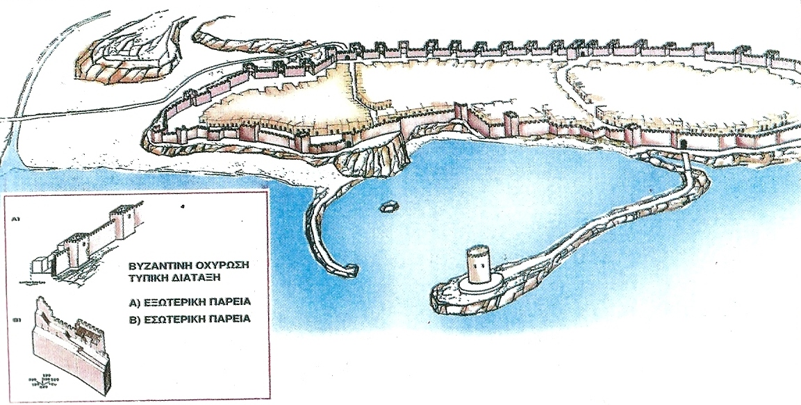
    Candia mapMuch later, during the Byzantine period, the settlement still existed and was called Kastro (Castle), due to the fortification wall protecting it. Traces of the Byzantine wall have been found near the port of Heraklion.

    In 824AD the Byzantine Castle fell to the hands of Saracen Arabs led by Ambou Hafs Omar or Apochapsis. The capital of Crete, Gortyn, was destroyed by them, as it was not seaside and did not serve the needs of the Saracen pirates. On the other hand, the small castle of Heraklion was ideal for providing a new basis for their predatory raids in the Mediterranean.

    After moving the capital of Crete to Heraklion Castle, they built a strong fortification. The Arab fortifications of Heraklion started from the current site of the Archaeological Museum of Heraklion, ran along today’s Daidalou and Handakos Street, ending at the sea. The wall was built of unbaked bricks, made of goat and pig hair. The wall was quite flat so that it could fit two carriages. The outside side of the walls was protected by a deep ditch, which could be filled with seawater in one hour. Because of this trench, the Arabs called the city of Heraklion "Trench Castle » (Rabdh el Khantak), a name that was used for many centuries (Candia).

    The Byzantines tried to regain Crete, because of its foremost geostrategic importance and so as to exterminate the pirates who were raping the Greek seas. However, the great fortress of Candia kept them away for many centuries. After several consecutive failing campaigns, Nikiforos Fokas in 961AD managed to free the island. Fearing a possible return of the Arabs, Fokas ruined the fortifications, the ditch, and built the fortress Rokka in Kanli Castelli (today’s Profitis Ilias village).

    Chandakas was shortly inhabited by Cretans and the Byzantines rebuilt new strong walls. These walls were built above the Arabic walls, while a gate was built at the point of today’s building Aktarika (next to the Lions square). The name of the gate was later known by the Venetians as Great Arch (Voltone).

    After regaining Crete, the Byzantines were closely involved with the defense of the island, by building forts and castles all over the island. At the same time, they installed several soldiers coming from all over the Byzantine Empire to repel pirate attacks.

    [widgetkit id=1639]

    The Venetian fortification of Heraklion
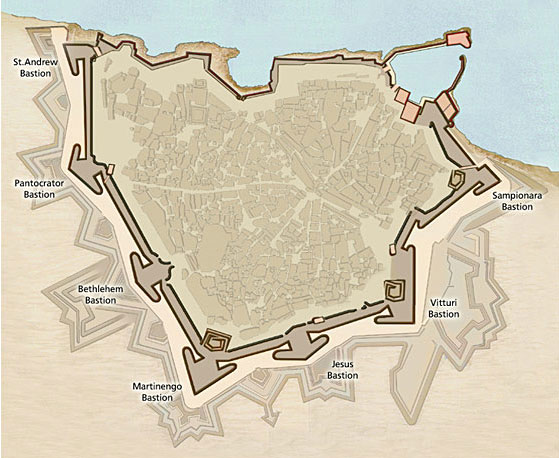
    Candia mapIn 1206, after 2.5 centuries of Byzantine presence on the island, the Genoese, led by the Maltese Henry Pescatore and his friend Alamanos da Costa occupied a large part of central Crete. Immediately, they fortified the big three castles of Candia, Sitiaand Rethymnonand twelve smaller forts in several positions.

    However, in the spring of 1209, the Venetians occupied the fort in Paliokastro(in the Linoperamata area) and on May 1217 they managed to completely get rid of the Genoese. Thus, Crete changed hands for more 4.5 centuries.

    The Venetians firstly used the Byzantine walls of Candia. They restored and adapted them to the demands of the martial art of the Era, based on spears, swords, bows, battering rams, rams, rocks, crossbows, and liquid fire. In this revised fortification, they incorporated many parts of the former Byzantine walls.

    The Venetian walls had straight sides with towers at distances. It started at the area called (today) Bendenaki, and ran along Handakos and Daedalou Streets, with Voltone gate still standing on its site. Then, the walls ran along today’s Beaufort Street and reached the town port. Outside these walls, radial roads led to the various places of Crete.

    During the first centuries of the Venetian rule, the threats for the Venetians were internal, coming from the Cretan people who could not tolerate slavery anymore. After the revolution of the brothers Kallergis (in 1364), which was suppressed in 1367, the Venetian-Cretan relations were significantly improved.

    After the fall of Constantinoplein 1453, the new raised danger came from the Turkish side. Thus, the Venetians started preparing their defense against the Turks by building dozens of forts on the island. Candia town grew continuously and the settlements were built without planning outside the walls, with the population outside the walls to be 4 times higher than in the castle.

    Also, after the discovery of gunpowder and the use of cannons in the 15th century, building a bigger and more powerful Venetian castle, which would protect the entire town of Candia, was necessary. The construction of the new walls (the current walls of Heraklion) began in 1462 and lasted more than a century. The initial projects were designed by the engineer Kampofregozo, but eventually, the plans of the military engineer Michel Sammicheli were used.

    The cost of construction funds was covered by Venice, the Kingdom of Crete, the Cretan people, the Church, and the Jews. All Cretan men (14-60 years old) were forced to work for one week, every year, with their animals and without getting paid and fed. The building materials were transported from the quarries of Katsabas, Hersonisos and the ruins of Knossos Minoan Palace.

    Around the walls, a deep ditch was formed, which transformed the city into an impregnable fortress. The walls of Candia served the latest fortification art of the time, ensuring the complete protection of the city.

    The triangular-shaped wall had its base on the coastal side and had an overall length of 3km. The moat, which was opened around it has very wide and deep. On the outer side of the trench, small forts were built called Revelini, to make it more difficult for enemies to approach the walls.

    [widgetkit id=1638]

    Bastions

    The walls were protected by seven bastions / ramparts. The bastion was a solid platform, which protruded from the walls, in order to protect a larger area and to support effectively the adjacent parts of the walls. The seven bastions of the walls of Heraklion are the following:

    1. On the northeast corner, opposite the present hotel Atlantis, was the bastion of Sand (Sabionera), with the rampart Zane.
    2. The southeastern corner (today Kapetanakio School) hosts the bastion Virouri with the homonym rampart.
    3. The tomb of Nikos Kazantzakis (now Kenourgia Porta) was built on the homonym bastion.
    4. At the top of the triangular wall, the enclosure was the Martinengo Bastion (where the tomb of Nikos Kazantzakis is located). Martinengo is the largest bastion of Heraklion.
    5. Opposite the hospital of Pananio, there is the bastion of Bethlehem.
    6. Next to the Gate of Pantokratoras (Chanioporta)was the homonym bastion.
    7. Lastly, the northwest corner of the walls hosted the bastion of Saint Andrew, the weakest of Candia.
    8. To supplement the city's fortifications, the Venetians demolished the little old fortress at the harbor entrance and built the new fortress Rocca al mare (Sea Fort) within 17 years. This is the famous fort Koules, which still dominates the old harbor.

    On the eve of the Cretan War (1630), the Venetians had equipped the castle and the fort with 428 cannons of various calibers. Due to the truly excellent fortification of Heraklion, the Venetians renamed Chandakas to Great Castle, a name that still survives.

    The Turkish Era

    The Ottomans conquered the Great Castle in 1669, after nearly 23 years of siege (May 29, 1648 - September 18, 1669), after the betrayal of the Venetian Andrea Barozzi, entering from the bastion of San Andreas. The siege of the castle the longest recorded in world history. After the occupation of Crete, the Turks used the defensive constructions of the Venetians to suppress the reactions of the Cretan people. They repaired the walls and fortresses of Heraklion.

    At the same time, they changed the names to the Turkish language. Thus, the Martinengo bastion was named Giouksek Tabia, orechione was named Bourtzi, bastion of San Andreas was named Giourous Kapisi, the Gate of Pantokrator was named Geni Kapou, the Gate Dermatas was named Kum Kapi, the Rocca al Mare was named Koules, etc. Therefore, it is very common to hear dual names for the monuments in Heraklion.

    The fortification of the Great Castle was neglected in times of peace. However, the fortification walls of Heraklion and the fortress of Koules have been preserved in excellent condition and are the best-preserved Venetian works in Europe.


  • The Minoan Era (3000 BC - 1200 BC)

    Crete is the birthplace of the first European civilization, the Minoan, which flourished between 3000 BC and 1200 BC mainly in Central and Eastern Crete. Even today, the majestic palaces of Knossos, Phaestus, Malia, Zakros, Tylissos, Arhanes, Monastiraki, Galatas, Kydoniaand the luxurious mansions at Agia Triada, Zominthos, Amnisos, Makrigialos, Vathipetroand Nerokourosreflect the splendor of the Minoan civilization through architectural, pottery, jewelry and painting masterpieces.

    The Minoan fleet, the strongest of its era, as evidenced by several findings in the Mediterranean, brought wealth to Crete from the trade of the famous Cretan cypress and agricultural products. Built in large yards, such as the shipyard of Agii Theodori at Vathianos Kambos, ships were loaded with timber, honey, wine, pottery and olive oil from the ports of Dia, Katsambas, Komos, Zakros, Psira, Mochlos, Niros, Petras, sailing towards all directions of the Mediterranean as far as Scandinavia.

    Women were equal to men and took part in all religious ceremonies, in sports, hunting, theater, dance, etc. Masterpieces of building architecture, painting, sculpture and goldsmithing continue to inspire even modern civilization. Linear A and Linear B Scripts remind of the Egyptian hieroglyphics, but they were original Greek scripts. Even today, the disc of Phaestus is one of the most famous mysteries of archeology and deciphering of its symbols remains a riddle.

    The worship of deities such as the Mother Goddess of fertility, the Mistress of the Animals, protector of cities, the household, the harvest, and the underworld dominated the religious tradition of the Minoans, who used many caves and mountain peaks as places of worship. Pilgrims from all over the island ascended to the peak sanctuaries of Youchtas and the cave of Hosto Nero to offer their votives, such as Minoan inscriptions or clay idols. Peak sanctuaries were also hosted atop summits Kofinas, Vrysinas, Petsofas, Traostalos, Karfi, etc. The Diktaean, Idaeanand Kamares Caves also played a prominent role in the worship of gods.

    Show Map

  • The Turkish forts of Fodele

    Fodele area was a very important passage during the Venetian and Turkish Era, which made the occupiers build towers and forts at almost every peak. The Turks wanted to fully control the passage of Fodele and simultaneously monitor the bay (the current beach of Fodele), where the Greek ships often beached for supporting the rebels.

  • The White Mountains

    The White Mountains, or Lefka Ori, is the largest massif on the island and its highest summit is Pahnes (2.453 m). The heart of this imposing range includes the Mountain Desert, where more than fifty peaks named Sori (piles), reminding of cones, exceed the altitude of 2.000 m. Dolines, reminding of upturned cones are formed at the foot of Sori peaks. This creepy and haunting landscape is a unique geological formation in the entire northern hemisphere.
    Hiking in the White Mountains requires fitness, experience and a good sense of orientation. There are several mountain shelters where mountaineers can spend their night.

    The highest mountain areas are covered by snow till late June. There are numerous caves, precipices, sinkholes and canyons. The most famous gorge is Samaria in the White Mountains National Reserve, but there are many more: to the south, the gorges of Aradena, Tripiti, Klados, Agia Irini, Imbros and Kallikratis, and to the north, the gorge of Vrissi, Therisso, Cyclamen, Boriano, Dittany, Kidoni and more.

    The White Mountains are home to the deepest caves in Greece. These include the dark sinkholes of Gourgouthakas and Leon. The most well-known plateaus include Omalos, Anopolis, Askyfou, Tavri and Niato.

    The White Mountains host a great variety of flora and fauna species, which are exclusively endemic (stenoendemic), not to be found anywhere else –not even in other parts of Crete. The areas on the southern side of the mountain range are covered with cypress, oak and pine trees, whereas humid areas favour the development of chestnuts, planes and other aquatic plants.

    [widgetkit id=826]

    {loadposition nearestplaces}

    What to see on the White Mountains:
  • Thripti Range

    Thripti Range is the fifth highest mountain range of Crete, also called Aori. The highest peak of Thripti mountains is called Stavromenos (1476m). The mountains of Thripti are covered by a beautiful pine forest, which has unfortunately shrunk due to human presence and fires.

    Moreover, near the Plateau of Thripti start the imposing wild gorge Ha and gorge Mesonas. On the southern slopes of these mountains there are some of the most scenic villages in Crete, such as the lush Orino village, and the seaside resort of Makrygialos. There are also the amazing green gorges of Pefki, Mylonasand Orino.

    Because of the rugged morphology and the ideal climatic conditions, the area of Thripti hosts several endemic species of flora such as arhontoxylo, aladania, anemoneand the Cretan cyclamen. Lastly, the walls of the canyons, especially the unreachable Ha Gorge, shelter threatened species of birds of prey like the endangered bearded vulture (gypaetus barbatus) and the golden eagle.

    [widgetkit id=832]

    {loadposition nearestplaces}


    What to see on the Thripti Range:
  • Thripti Reichweite

    Thripti Reichweite ist die fünftgrößte Bergkette von Kreta, auch Aori genannt. Der höchste Gipfel der Thripti Berge heißt Stavromenos (1476 m). Die Berge von Thripti sind von einem wunderschönen Pinienwald bedeckt, der leider durch menschliche Gegenwart und Brände geschrumpft wurde.

    Außerdem beginnen in der Nähe des Plateaus von Thripti die imposanten wilden Schluchten von Ha und Mesonas. An den südlichen Hängen dieser Berge befinden sich einige der schönsten Dörfer auf Kreta, wie das üppige Orino Dorf und der Badeort Makrygialos. Es gibt auch die erstaunlichen grünen Schluchten von Pefki, Mylonas und Orino.

    Wegen der schroffen Morphologie und der idealen klimatischen Bedingungen beherbergt das Gebiet von Thripti mehrere endemische Arten von Flora wie Arhontoxylo, Aladania, die kretische weiße Anemone und die kretischen Alpenveilchen. Schließlich bedrohten die Mauern der Schluchten, vor allem die unerreichbare Ha Schlucht, Schutzgärten von Raubvögeln wie der gefährdete Bartgeier (gypaetus barbatus) und der goldene Adler.

    [widgetkit id=832]

    {loadposition nearestplaces}

  • Top destinations

    Nothing is repeated in Crete. Enormous geological contradictions and special weather conditions have formed unique landscapes, surprising the visitors and keeping senses constantly alert. The most popular sights are a good start for your short stay in Crete, as it is possible to want to return back soon.

  • Top Destinations in Central Crete

    The central part of Crete hosts the most fertile planes on the island, with vast olive groves and vineyards, watered by the massifs of Psiloritisand Dikti. This fertile land was the main growth driver for the development of the greatest cities since the ancient times and still feeds the main population of the island. If you stay in Heraklion or Rethymnon area, consider visiting the following places.

  • Top Destinations in East Crete

    East Crete is the most quiet part of the island, retaining most of its genuine character and style. Although it is generally the driest land in Crete, you will be amazed by the lush green oases formed mainly around the low mountain ranges of the prefecture. Here we present you several, but a few, places to visit when staying at Agios Nikolaos, Sitia or Ierapetra cities.

  • Top Destinations in West Crete

    West Crete has all one can wait to see in Crete: Deep and wild gorges, steep mountains, green valleys and woods, amazing beaches, very important archaeological sites and historical venues and amazing towns, such as Chania. If you decide to stay in the area of Chania, consider visiting the following must-see attractions around. Of course, spending several hours in the amazing town of Chania is absolutely required. 

  • Towers and Chateaus

    The construction of towers was one of the several defensive measures taken by the rulers of Crete (mainly Venetians and Ottomans) to strengthen their domination and protect them from the ongoing revolutionary movements of the Cretans. Towers were also built by the Byzantines (between 961AD-1204AD so as to protect the province of Crete from the raids of pirates.

    A tower was a tall edifice built on a strong base, used mainly for defensive purposes. Its shape was circular, semicircular, square or polygonal. Towers were usually built in the exterior walls of a castle, near its gates and on the corners of the fortresses.

    Here we will deal with independent towers that were built mainly in the mainland of Crete, aiming at the enforcement of the conquerors against the Cretan people, but also with some towers built near the shores to supervise the sea and to warn the residents for enemies. These coastal towers were called torrete di aviso (warning towers). The Venetians in 1573 planned to build many torrete di aviso at distances that would allow visual contact. These were multi-storey towers and someone could move from floor to floor with removable wooden ladders.

    While the castles and fortresses were public buildings, as they were erected under public expenses or with the fatigues of the native population, the towers were smaller buildings which were built mostly by rich individuals or feudal families at their own expense. Thus, the towers usually bore a family crest above their main entrance, which was the identity of the tower. Initially, the systematic construction of the towers started by the Venetian feudal lords and later by the Turks.

    Also, in this subsection we shall refer to some buildings which do not have the characteristics of defensive towers, but were actually luxurious mansions for rulers that lived in the villages. The towers, as they are called, were configured to meet the housing needs of the lords, but also offered various administrative and military services. They were known as villas, seray, konak and were playing the role of a chateau.

    According to some historical records, the number of towers per province was: Sitia 22, Mirabello 16, Ierapetra 15, Pediada 24, Rizos 4, Kairourgio 9, Pirgiotisa 7. That number soared after 1869, when the Turks built many public towers across the island of Crete (called Koules), which are presented in separate section. Most of the towers are now gone, as they were destroyed by the Cretan rebels.

    Show Map

  • Tradition

    The multicultural and distant past of Crete is reflected in all aspects of modern Cretan people, such as language, dance, music, food, arts and crafts.

    Folk tradition of Crete constitutes an inexhaustible contemporary cultural entity with customs, materials, spiritual features and ancient habits that have formed the core of the modern Cretan life over the years.

    The Cretan dialect is considered the oldest in Greece and has been a subject of study and research. Dozens of words have ancient or archaic origin or come from linguistic influences from Arabs, Venetians and Ottomans.

    [widgetkit id=1624]

  • Traditional Occupations

    Many primitive crafts remain alive on the island, while they have become obsolete in other parts of Greece. There are still several areas of the island resisting to the invasion of modern technology.

    Potters at Thrapsano, Kentri and Margarites mold clay just like the Minoans did thousands years ago. Hundreds of vessels, identical to those found in the Minoan palaces, are still used for storing olive oil, grains and other agricultural products.

    Carpenters transform wood into traditional musical instruments, such as the lyre and the lute. Vori, Zaros, Rethymnon, Neapolisand Kritsaare places famous for their long tradition in the manufacture and development of such instruments.

    Cobblers in major cities and villages such as Anogia, make the traditional stivania, the resistant Cretan leather boots.

    Knife manufacturers in Chaniaand Heraklion convert steel into the famous Cretan knife, the inseparable companion of each Cretan. Engraved depictions and poems adorn the blades.

    Women's cooperatives in all major villages still weave on the loom, reminding of the just as they used to do in Minoan times. Sariki, the Cretan head scarf with fringes resembling tears, symbolizes lamentation for the hardships Crete experienced in the past centuries. The black sariki is worn as a sign of mourning, while the white sariki is worn as a sign of joy during weddings, feasts, births and christenings.

    Wood and marble sculptors give life to materials of the Cretan land by carving logs and stones and by manufacturing elaborate works, mainly of ecclesiastical art. Visitors can visit venues exhibiting woodcraft at the villages of Axos and Asteri and marble works at the International Sculpture Symposium in Venerato.

  • Traditional Products

    Buy the wonders of the Cretan diet that attracted scientists around the world, with the results of research showing a surprisingly positive impact on Cretan health, low rates of disease, and lower mortality than other areas of the planet.

  • Tulpen

    Die Tulpen von Kreta sind sehr beeindruckend, obwohl fast niemand weiß, dass es mehrere Tulpenarten gibt. Dies sind die Tulipa cretica auf Kreta, die rote Tulipa im Plateau Gious Kambos, die Tulipa goulimyi in Chania, Tulipa saxatilis in Omalos Plateau und die bergigen Tulipa saxatilis.

  • Türkische Festungen (Koules)

    Während der kretischen Revolution von 1866-1869 wurde das Osmanische Reich gezwungen, mehrere Paschas auf Kreta zu schicken, aber die Anstrengung erwies sich als fruchtlos. Der letzte Pascha, der auf die Insel geschickt wurde, war Avni Pascha, der dem andauernden Widerstand der Kreter gegenüberstand und beschloss, seine operative Taktik zu ändern.

    So waren die Maßnahmen, die er nahm:

    • Er gab denjenigen, die dem Muftis die Treue erklärten, einen politischen Schutz.
    • Die türkische Flotte beherrschte die Nordküste Kretas, um die Versorgung aus Griechenland zu stoppen.
    • Sie setzen einen Preis auf die kretischen Rebellen, mit 500 osmanischen Pfund jeder.
    • Er setzte Kurden und Tscherkessen auf die Insel, um die muslimische Bevölkerung zu stärken.
    • Er entwarf ein ganzes System von großen und kleinen Türmen (genannt Koules) an prominenten Orten auf Kreta, um die Insel vollständig zu kontrollieren.

    Konkret wurde Kreta in fünf Provinzen aufgeteilt, deren Gouverneure den Bau von Koules unternahmen. Die Koules wurden auf hohen Hügeln, Kreuzungen, Häfen, Passagen gebaut und ihre Wächter spähten die Rebellen und die transportierenden Christen. Sie haben im Falle eines Notfalls intermittiert (mit Fanfare oder Feuer) und lieferte die Warnmeldung seriell zum Hauptlager (Kiesle). Die Wirksamkeit von Koules war für die Kreter verheerend, da sie nicht mehr leicht miteinander kommunizieren konnten.

    Die Kreter reagierten aktiv bei der Errichtung der Türme, belästigten die Bauarbeiter, zerstörten die Gebäude am Abend oder zerstörten Kalköfen, von wo aus die Türken Kalk zum Bauen lieferten. Trotzdem gelang es Avni Pascha, sein Projekt mit erfahrenen bulgarischen und armenischen Handwerkern zu vervollständigen, die bis August 1868 mehr als 60 Koules hatten und 2 Monate später hat diese Zahl auf 150 erhöht.

    Wie erwähnt, nannten die Türken diese Türme Koules, nach der türkischen Koule. Der einzige Unterschied zwischen ihnen und den restlichen Türmen der Insel ist, dass Koules vom Staat gebaut wurde, anstatt von privaten Feudalherren (hauptsächlich venezianischen).

    Die Kreter, während sie sich selbst befreien wollten, zerstörten mehrere Koules, von denen viele noch nicht existieren. Allerdings haben Dutzende von Gebieten auf Kreta relevante Ortsnamen (koule oder pirgos (Turm)), was die ehemalige Existenz von Türmen impliziert. Wegen der großen Anzahl der Koules existieren sie immer noch.

  • Turkish Forts (Koules)

    During the Cretan Revolution of 1866-1869, the Ottoman Empire was forced to send several pashas in Crete, but the effort proved fruitless. The latest Pasha sent to the island was Avni Pasha, who faced the continuing resistance of the Cretans and decided to change his operational tactics.

    Thus, the measures he took were:

    • He provided political protection to those who declared allegiance to the muftis.
    • The Turkish fleet ruled the northern coast of Crete, so as to stop supplies coming from Greece.
    • Put a price on the Cretan rebels, with 500 ottoman pounds each.
    • He settled Kurds and Circassians to the island, in order to strengthen the Muslim population.
    • He designed an entire system of large and small towers (called koules) in prominent locations throughout Crete, in order to fully control the island.

    Specifically, Crete was divided into five provinces, the governors of which undertook the construction of koules. The koules were built on high hills, crossroads, ports, passages and their guards spied the rebels and the transporting Christians. They intercommunicated (with fanfare or fire) in case of an emergency and delivered the alert message serially to the main camp (called Kiesle). The effectiveness of Koules was devastating for the Cretans, as they could no longer easily intercommunicate.

    The Cretans reacted actively during the erection of the towers, harassing the builders, destroying the buildings in the evenings or destroying lime furnaces, from where the Turks supplied lime for building. Nevertheless, Avni Pasha managed to complete his project by using experienced Bulgarian and Armenian craftsmen, who until August 1868 had built more than 60 koules and 2 months later this number increased to 150.

    As mentioned, the Turks called these towers koules, after the Turkish kule. The only difference between them and the rest towers of the island is that koules were built by the state, rather than by private feudal lords and onwers (mainly Venetian).

    The Cretans, while trying to free themselves, destroyed several Koules, many of which do not currently exist. However, dozens of areas on Crete have relevant place names (koule or pirgos (tower)), that implies the former existence of towers. Due to the large number of the Koules, here we will not deal with all of them, but a few that still exist.

    Show Map

  • Türme und Chateaus

    Der Bau von Türmen war eine der verschiedenen Verteidigungsmaßnahmen, die von den Herrschern Kretas (vor allem Venezianern und Türken) ergriffen wurden, um ihre Herrschaft zu stärken und sie vor den laufenden revolutionären Bewegungen der Kreter zu schützen. Die Türme wurden auch von den Byzantinern gebaut (zwischen 961AD-1204AD, um die Provinz Kreta vor den Überfällen von Piraten zu schützen. Die Burgen und Festungen waren öffentliche Gebäude, da sie unter öffentlichen Ausgaben oder mit den Erschöpfungen der einheimischen Bevölkerung errichtet wurden. Die Türme waren kleinere Gebäude, die vorwiegend von reichen Einzelpersonen oder Feudalfamilien auf eigene Kosten gebaut wurden. So trugen die Türme in der Regel einen Familienkamm über ihrem Haupteingang, der die Identität des Turms war, anfangs begann die systematische Konstruktion der Türme von den venezianischen Feudalherren und später von den Türken.

  • Tymbaki Stadt

    Timbaki ist eine kleine Stadt, die 65 km südlich von Heraklion liegt, auf der Ebene von Messara. Sie liegt in der Nähe des Strandes der Kokkinos Pirgos, des alten Palast von Phaestus und der minoischen Villa in Agia Triada. Ihre Bewohner sind vor allem in der Landwirtschaft beschäftigt, da die Gegend voll von Olivenhainen und Gewächshäusern ist. Tatsächlich sind die Gewächshäuser so viele, dass die meisten Gemüse im Ausland täglich exportiert werden.

    Die Stadt hat keine besonderen Schönheiten zu zeigen, da die meisten Gebäude modern und hässlich sind. Sie können die Metropolitankirche St. Titus besuchen und Ihren Kaffee auf dem Hauptplatz oder am Strand von Kokkinos Pirgos trinken.

    Der Hauptgrund für die hässliche moderne Architektur von Timbaki ist die Tatsache, dass das Dorf evakuiert wurde und alle Häuser von den Deutschen während des Zweiten Weltkrieges abgerissen wurden und später von Grund auf neu aufgebaut wurden. Die Deutschen hielten ein paar Gebäude auf und nutzten die Materialien aus den abgerissenen Häusern für den Bau des nahe gelegenen Flughafens von Timbaki, der das gesamte südöstliche Mittelmeer kontrollieren konnte. Noch heute ist der Flughafen in Betrieb, aber er bietet vor allem Dienstleistungen für die Offiziere der Luftwaffe als Sommerort an. Im Sommer veranstaltet die Startbahn häufige Autorennen, während ein Himmel Tauchclub am Flughafen operiert.

    Der größte Fluss von Messara, Geropotamos, entleert sein Wasser in der Nähe von Timbaki und bildet einen kleinen Sumpf an der Stelle Katalyki. Vor einigen Jahrhunderten hielt die Malaria, die durch die lokalen Sümpfe verursacht wurde, die Entwicklung von Timbaki weg.

    [widgetkit id=1349]

    hotels booking Crete

    {loadposition nearestplaces}

  • Tymbaki Town

    Timbaki is a small town located 65km south of Heraklion, on the plain of Messara. It is positioned near the beach of the Kokkinos Pirgos, the ancient palace of Phaestus and the Minoan villa in Agia Triada. Its residents are mainly engaged in agriculture, as the area is full of olive groves and greenhouses. Indeed, the greenhouses are so many, that most of the vegetables are exported abroad on daily basis.

    The city has no special beauties to show. You could visit the metropolitan church of St. Titus (Agios Titos) and drink your coffee in the main square or on the beach of Kokkinos Pirgos.

    The main reason for the ugly modern architecture of Timbaki is the fact that the village was evacuated and all houses were demolished by the Germans during the Second World War, and later rebuilt from scratch. The Germans kept a few buildings stay in and used the materials from the demolished houses for building the nearby airport of Timbaki, which could control the entire southeastern Mediterranean Sea. Even today the airport is operating, but it mainly offers services to the officers of the Air Force as a summer resort. On summers, the runway hosts frequent car races, while one sky diving club operates in the airport.

    The largest river of Messara, Geropotamos, empties its waters near Timbaki and forms a small marsh at the position Katalyki. Before several centuries, malaria caused by the local marshes kept the development of Timbaki away.

    [widgetkit id=1349]

    hotels booking Crete

    {loadposition nearestplaces}

  • Venetian Harbor of Chania

    The Venetian Port of Chania with the Egyptian Lighthouse is bigger than the rest two ports of the same era, that of Heraklionand Rethymnon. A walk along its sides is one of the best experiences in Greece, as the entire area in conjunction with the Old Venetian Town is a vibrant Venetian monument.

    During the Venetian and Turkish periods, Chania presented a high development in commerce and marine mercantile. Not only in imports but also the export of various products was notable, despite the lack of a large and safe port. Since this time, it was common knowledge that the port of Chaniawas vulnerable due to the weather conditions and for this reason, it was not considered an appropriate port. The natural port of Souda, on the other hand, was in a much better position and was perfect for a port.

    After the occupation of the city by the Genoans, the need for the construction of a port was once again highlighted, and the local authorities started the construction works during the Venetian period. In 1302, the request was submitted to the government by rector Marino Gradenigo and was finally accepted.

    The first phase of the construction of the port was between 1320 and 1356. However, during this time it was once again realized that the natural condition and morphology of the port was inappropriate, as the port was overall small in size and shallow, it was vulnerable to north and west winds, and its east basin suffered from alluvions. Thus, the reports of the officials often record the urgent need to clean and deepen the port (especially its east basin).

    After the revolution of "Aghios Titos" (1363-64), the port of Chania was abandoned and the port of Heraklion was used instead, as the port of Rethymnon presented similar problems. During the Venetian period, in 1551, a second request was submitted to deepen the port of Chania and to construct a wall with battlements to protect the ships from the rocks and reefs.

    In 1645 however, the city falls into the hands of the Turkish army after the siege of Chania. The occupation of Crete by the Turks was official in 1669, after 25 years of war when "Handakas" (Heraklion) fell. The new rulers of Crete had no interest to maintain the port of Chania, which was completely neglected during the Ottoman period.

    Between the years 1831-1841, Crete was assigned to the Regent of Egypt, Mehmet Ali, as a gift for his services to the Sultan during the 1821 revolution in Crete and Peloponnese. The value of the port of Chania was then recognized, as well as its potential to improve the local economy. It is said that Mehmet Ali ordered Mustapha Pasha to clean the basin of the port of Chania, conduct maintenance works, and construct the lighthouse. Indeed, the construction works were finally completed, after a lot of effort and money.

    However, even then the ships were not able to approach the land, especially when the weather conditions were harsh, and the passengers and goods were transferred by small boats from the ships to the land, in front of the Mosque of "Kioutsouk Hassan", commonly known as "Giali Tzamisi".

    Nowadays, the picturesque Venetian port of Chania gathers a large number of visitors and local people, especially during the summer months. There are many restaurants, taverns, bars, and cafeterias lengthwise to the coastline to offer you a pleasant time and entertainment.

  • Venetian Harbor of Heraklion

    Next to the modern port of Heraklion, the visitor can admire the small picturesque Venetian harbor, currently serving as a marina with the impressive fortress of Koules that once protected its entrance. The 2km long jetty of the modern port starts here and is one of the favorite walk tours of the citizens.

    Opposite Koules, at the point where there is now the café Marina, until the early 20th century a smaller fort was built to protect the other side of the entrance, called Small Koules. In the coastal avenue we can still see the surviving oblong arched shipyards, the tank of Zane (next to the large shipyards), and the salt storage house (between the large and the small shipyards).

    The first major port constructions were carried out by the Arabs in the 9th - 10th century, in order to use Heraklion as a base for their pirate raids. The port was also used for the Byzantine Castle of Handax(the name of Heraklion in that era) after 961 AD. During the Venetian era, the port of Candia(as the Venetians called Heraklion) turned to the most important port in the Eastern Mediterranean with the largest export activity. In the 17th century the port could fit 50 galleys and, especially during the Cretan War (against the Turks) the entrance was blocked each night by a huge metal chain. The Venetian exports to Europe included the famous Malvasia wine (one of the most famous wines of that era), salt (mainly from Elounda), honey, cheese, beeswax, silk, raisins, cotton, and olive oil. 

    During the Ottoman period, the Turks retained the use of this very important harbor. The beautiful harbor however suffered great destructive alterations by the modernization trend of the 20th century, in order to make room from the seaside road and the new port. Most of the shipyards, Small Koules and the Gate of the Molos were demolished. The last gate was built on the starting point of the current pedestrian road of August 25 and controlled the entrance to the harbor.

    [widgetkit id=1340]

  • Venezianischer Hafen von Chania

    Der venezianische Hafen von Chania mit dem ägyptischen Leuchtturm ist der größere Rest von zwei Häfen der gleichen Ära, von Heraklion und Rethymnon. Ein Spaziergang entlang seiner Seiten ist eine der besten Erlebnisse in Griechenland, da das gesamte Gebiet in Verbindung mit der alten venezianischen Stadt ein lebendiges venezianisches Denkmal ist.

    Während der venezianischen und türkischen Periode stellte Chania eine hohe Entwicklung in der Handelskultur dar. Nicht nur im Import, sondern auch der Export von verschiedenen Produkten war bemerkenswert, trotz des Mangels an einem großen und sicheren Hafen. Seit dieser Zeit war es allgemein bekannt, dass der Hafen von Chania aufgrund der Wetterbedingungen anfällig war und deshalb kein geeigneter Hafen war. Der natürliche Hafen von Souda war aber in einer viel besseren Lage und war perfekt für einen Hafen.

    Nach der Besetzung der Stadt durch die Genues wurde die Notwendigkeit für den Bau eines Hafens noch einmal hervorgehoben, und die örtlichen Behörden begannen die Bauarbeiten während der venezianischen Zeit. Im Jahr 1302 wurde die Anfrage von der Rektorin Marino Gradenigo an die Regierung gerichtet und schließlich akzeptiert.

    Die erste Phase des Baues des Hafens lag zwischen 1320 und 1356. Doch während dieser Zeit wurde wieder einmal erkannt, dass der natürliche Zustand und die Morphologie des Hafens unangemessen waren, da der Hafen insgesamt klein und flach war, anfällig für Nord- und Westwind, und sein Ostbecken litt unter Alluvions. So berichten die Beamten oft die dringende Notwendigkeit, den Hafen zu reinigen und zu vertiefen (vor allem sein Ostbecken).

    Nach der Revolution von "Aghios Titos" (1363-64) wird der Hafen von Chania aufgegeben und der Hafen von Heraklion wird stattdessen verwendet, da der Hafen von Rethymnon ähnliche Probleme darstellte. Während der venezianischen Zeit wurde 1551 ein zweiter Antrag gestellt, den Hafen von Chania zu vertiefen und eine Mauer mit Zinnen zu bauen, um die Schiffe vor den Felsen und Riffen zu schützen.

    Im Jahre 1645 aber fällt die Stadt nach der Belagerung in die Hände der türkischen Armee. Die Besetzung von Kreta durch die Türken war offiziell im Jahre 1669, nach 25 Jahren Krieg, als "Handakas" (Heraklion) fiel. Die neuen Herrscher von Kreta hatten kein Interesse daran, den Hafen von Chania zu erhalten, der während der türkischen Zeit völlig vernachlässigt wurde.

    Zwischen den Jahren 1831-1841 wurde Kreta dem Regenten von Ägypten, Mehmet Ali, als Geschenk für seine Dienste an den Sultan während der Revolution von 1821 auf Kreta und Peloponnes zugewiesen. Der Wert des Hafens von Chania wurde dann erkannt, sowie sein Potenzial, die lokale Wirtschaft zu verbessern. Es wird gesagt, dass Mehmet Ali Mustapha Pascha bestellt hat, um das Becken des Hafens von Chania zu reinigen, Wartungsarbeiten durchzuführen und den Leuchtturm zu bauen. In der Tat wurden die Bauarbeiten endlich abgeschlossen, nach viel Aufwand und Geld.

    Doch selbst dann waren die Schiffe nicht in der Lage, sich dem Land zu nähern, besonders wenn die Wetterbedingungen hart waren, und die Passagiere und Waren wurden von kleinen Booten von den Schiffen in das Land, vor der Moschee von "Kioutsouk Hassan" übertragen, allgemein bekannt als "Giali Tzamisi".

    Heutzutage sammelt der malerische venezianische Hafen von Chania eine große Anzahl von Besuchern und Einheimischen, besonders in den Sommermonaten. Es gibt viele Restaurants, Tavernen, Bars und Cafeterien in Längsrichtung zur Küste, um Ihnen eine angenehme Zeit und Unterhaltung zu bieten.

  • Venezianischer Hafen von Heraklion

    Neben dem modernen Hafen von Heraklion kann der Besucher den malerischen venezianischen Hafen bewundern, der derzeit als Yachthafen mit der beeindruckenden Festung Koules dient, die einst den Eingang beschützt hat. Die 2 km lange Anlegestelle des modernen Hafens beginnt hier und ist eine der beliebtesten Wandertouren der Bürger.

    Gegenüber Koules, an der Stelle, wo es jetzt das Cafe Marina gibt, wurde bis zum frühen 20. Jahrhundert eine kleinere Festung gebaut, um die andere Seite des Eingangs zu schützen, genannt Kleine Koules. Auf der Küstenstraße können wir noch die überlieferten, länglichen gewölbten Werften, den Panzer von Zane (neben den großen Werften) und das Salzlagerhaus (zwischen den großen und den kleinen Werften) sehen.

    Die ersten großen Hafenkonstruktionen wurden von den Arabern im 9. - 10. Jahrhundert durchgeführt, um Heraklion als Basis für ihre Piratenangriffe zu nutzen. Der Hafen wurde auch die byzantinische Burg von Handax (der Name von Heraklion in dieser Ära) nach 961 n.Chr. Während der venezianischen Ära wandte sich der Hafen von Candia (wie die Venezianer Heraklion nannten) zum bedeutendsten Hafen im östlichen Mittelmeer mit der größten Exporttätigkeit. Im 17. Jahrhundert konnte der Hafen 50 Galeeren platzieren, und vor allem während des kretischen Krieges (gegen die Türken) wurde der Eingang jeden Abend durch eine riesige Metallkette blockiert. Die Venetianer exportierten nach Europa den berühmten Malvasia-Wein (einer der berühmtesten Weine dieser Ära), Salz (hauptsächlich aus Elounda), Honig, Käse, Bienenwachs, Seide, Rosinen, Baumwolle und Olivenöl.

    Während der osmanischen Zeit behielten die Türken den Gebrauch dieses sehr wichtigen Hafens bei. Der schöne Hafen erlitt jedoch durch den Modernisierungsverlauf des 20. Jahrhunderts große zerstörerische Veränderungen, um von der Seestraße und dem neuen Hafen Platz zu machen. Die meisten Werften, Kleine Koules und das Tor der Mole wurden abgerissen. Das letzte Tor wurde am Ausgangspunkt der heutigen Fußgängerstraße vom 25. August gebaut und kontrollierte den Eingang zum Hafen.

    [widgetkit id=1340]

  • Villas

    Find the best villas at the best prices in Crete, Greece.

  • Vrysses (Apokoronas)

    Vrisses is a small picturesque town with less than 1000 inhabitants relatively close to Chania city and constitutes the administrative seat of the municipality of Apokoronas. The residents of Vrysses mainly deal with tourism and cultivation of citrus fruits and olives.

    Although a relatively modern settlement, the area has been inhabited since the Minoan era. Nearby were the towns of Amphimalion and Philippos, while on the Boutakas River lies the ancient bridge known as the Greek Arch (Elliniki Kamara), one of the oldest surviving bridges in Greece. In history the settlement was a center of revolutionary action, a battlefield against the Ottomans in 1866-69, the seat of the Transitional Committee against the Ottomans in 1895 and was leveled by German bombings in 1941.

    Vrysses today is known for the rivers Boutakasand Vrysianos that merge in the center of the settlement, next to the bridge of 1942. A large park has been formed at the point of the rivers, where one can enjoy coffee and food under the huge plane trees next to ducks.

    [widgetkit id=2587]

    hotels booking Crete

    {loadposition nearestplaces}

  • Wälder

    Kreta wurde einmal mit dichten Wäldern bedeckt, so dass seine Berge "Idea" genannt wurden, d.h. bewaldet. Leider sind diese Wälder durch Holzfällen, Überweidung und Brände fast verschwunden. Trotzdem sind die wenigen verbleibenden Wälder einige der schönsten Landschaften auf Kreta und ein typisches Beispiel der mediterranen Vegetation, die einst die gesamte Insel bedeckte.

    Jedes Gebiet von Kreta hat seine eigenen charakteristischen Bäume. Die Provinzen Apokoronas und Sfakia sind mit Zypressen bedeckt, Thrypti hat vor allem Kiefern, die Tiefebene des zentralen Kretischen Gasthauses Arbutus, die feuchten Gebiete von Kissamos sind mit Kastanien bedeckt, während die Diktäer und die Weißen Berge Heimat von Eichen sind.

  • Wandern

    Der beste Weg, um Kreta zu erkunden, ist, die abgefahrenen Wege zu verlassen, jenseits der Orte, die mit dem Auto erreicht werden, und den alten Wegen zu folgen, die herrlichen Düfte der Kräuter in den Schluchten zu erkunden, auf den Gipfeln der höchsten Berge zu klettern und den Blick in die Tiefe zu genießen: blaues kretisches und libysches Meer am Horizont.

    Ein großer Teil der Wege führt durch Gebiete, die für geschützte Gebiete erklärt wurden. Das berühmteste von ihnen ist das Nationalreservat der Weißen Berge (Lefka Ori), eine der sieben Reserven Griechenlands, die die Heimat der Samaria Schlucht ist. Weitere Schutzgebiete von außergewöhnlicher natürlicher Schönheit, die als Natura 2000 gekennzeichnet wurden, sind die gesamten Gebiete von Dikti, Ida (Psiloritis), Kedros, Asterousia, Youchtas und Thripti, die Halbinseln Gramvousa, Rodopos und Sidero Insel und besondere Orte wie Lafonissi, Georgioupolis, Kap Lithino, die felsige Küste westlich von Rethymnon, etc.

    Darüber hinaus können die Liebhaber des Geo-Tourismus neue Orte zu entdecken, da die Psiloritis Range und Sitia Berge als geschützte Geopärke erklärt wurden. Solche Projekte zielen auf die Förderung solcher Orte und die Bereitstellung von Informationen über sie.
    Viele Reisebüros bieten Pakete und Experten-Führer für das Wandern auf der Insel und es gibt viele Wander-und Bergsteigen Vereine. Wichtige Bergrennen werden auch organisiert, wie Psiloritis Rennen und der Marathon von Samaria.

  • Weitere Wanderwege auf Kreta

    Es gibt viele schöne Wanderwege, die auf Kreta einen Besuch wert sind. Alte Steinpfade, die einst die Hauptstraßen der Insel waren, sind heute ein Magnet für Naturliebhaber.

  • Wells - Fountains - Cisterns

    In areas of Crete, where the lack of springs makes water difficult to find, the people built cisterns to store rainwater or wells to find underground water. Many of these are worth mentioning as they are architectural ornaments. Similarly, in many areas we meet elaborate fountains, which quenched passer's thirst or were used for washing clothes etc.

  • Windmills and Watermills

    In western Crete, where rainfalls are quite frequent, water mills were used for grinding grain. However, in drier Eastern Crete residents used the wind for their needs. Indeed, many clusters of windmills, called milotopi, are met in most places, especially at northern Mirabelo. The windmills of Ambelos at Lassithi Plateau form the largest milotopi in Greece. Apart from grinding grain, the need for pumping water to irrigate crops at the plateau of Lassithi inspired the construction of lightweight metal windmills that pumped water from wells.

    About 12.000 metal windmills operated in the middle of the previous century at Lassithi Plateau, forming the first wind farm in the world with estimated installed power of 5MW.

  • Windsurfen

    Windsurfing ist ein Wassersport, der die Disziplinen Segeln und Surfen kombiniert. Der Sport tauchte zuerst in Kalifornien in den sechziger Jahren auf und verbreitete sich schnell zu allen Ländern, unter denen auch Griechenland ist.

    Kouremenos Bucht, neben Palekastro, ist definitiv der König der Windsurf-Resorts auf Kreta und einer der berühmtesten Orte in Griechenland (und Europa). Hier finden Liebhaber von Surfen und Kitesurfen alles, was sie brauchen; Starke Winde und Ausrüstung zu mieten. Ein wenig nördlich, am Fuße des Kapes Sidero, finden Sie die talentiertesten Athleten des Sports am einsamen Strand von Tenta und Eligas. Zu anderen Windsurfen Orten auf Kreta gehören Falasarna, Elafonisi, Kedrodasos, Stavros, Elounda, Amoudara in Heraklion und Hersonissos.

    Einer der wichtigsten Orte für Wellen-Segeln in Griechenland ist die felsige Bucht Papadiokambos, auch bekannt als Faneromeni, ein paar Meilen westlich von Sitia.

  • Windsurfing in Crete

    Windsurfing is a water sport that combines the disciplines of sailing and surfing. The sport first emerged in California in the 1960s and spread rapidly to all countries, Greece between them.

    Kouremenos bay, next to Palekastro, is definitely the king of windsurfing resorts in Crete and one of the most famous spots in Greece (and Europe). Here, lovers of surfing and kite-surf will find all they need; strong winds and equipment to rent. A little northern, at the base of Cape Sidero, you will find the most talented athletes of the sport at the secluded beach of Tenta and Eligas. Other windsurfing locations in Crete include Falasarna, Elafonisi, Kedrodasos, Stavros, Elounda, Amoudarain Heraklion and Hersonissos.

    One of the most important sites for wave sailing in Greece is the rocky bay Papadiokambos, also known as Faneromeni, a few miles west of Sitia.

  • Wine

    Wine is an indispensable part of Cretan food culture and hospitality. Wine-making traditions have been kept alive on the island for 4,000 years. Cretans have taken loving care of their vines to make wine or raisins. These two products became quite famous and provided significant leverage for the overall trade of the island, with important exports since the time of the Venetian conquest. Every household in Crete produces its own wine and tsikoudia, in adequate quantities to cover the needs of the family and even give some away to friends. To this age, taking care of the vine is deemed truly important by all families.

    Standardized Cretan wine, however, had a hard time gaining the recognition it deserved in international markets. However, over the past decades or so, the tides seem to be turning in favor of the Cretan vineyard: Cretan wine has been spreading, winning awards together with its own special place in the wine lists of prestigious restaurants around the world. Boasting eleven unique indigenous grape varieties, Cretan producers are able to bottle single varietal wines, as well as intriguing blends with other European varieties that grow on the island.

    The most famous varieties that have found their way back into our glasses include both whites (vilana, vidiano, dafni, thrapsathiri, malvazia, moschato, plito) and reds (kotsifali, and most importantly, liatiko, and mantilari).

    The Cretan Winemakers Network is the first significant cluster of winemakers in Crete, consisting of 30 producers and wineries. The Network has achieved excellent results in promoting and marketing Cretan wine in the global market. This effort is also supported by shared actions and events organized by the winemakers to promote Cretan wines. Producers make the most out of the common promotion strategy and participation in expos, indeed putting the motto "United we stand" into practice.

  • Woods

    Crete was once covered with dense forests, thus its mountainswere called "Idea", i.e. wooded. Unfortunately these forests have almost disappeared due to logging, overgrazing and fires. Even so, the few remaining forests are some of the most beautiful landscapes in Crete and a typical sample of the Mediterranean vegetation that once covered the entire island.

    Each area of Crete has its own characteristic trees. The provinces Apokoronas and Sfakia are covered with cypresses, Thryptihas mainly pines, the lowlands of central Crete host arbutus, the humid areas of Kissamos are covered with chestnuts, while the Diktaean and the White Mountains are home to oaks.

    The most important cypress woods are met at the National Reserve of the White Mountains, Kroustas, the lowlands of Apokoronas and the mountainous province of Kydonia. The greatest oak wood is located at Rouvas at Psiloritis and it is home to rare animals and plants, including the endemic Cretan wildcat and the orchid Cephalanthera cuculata. Extensive pine woods are formed at the mountain of Thripti, at eastern Dikti, Sfakia, Asterousia Range and southern Psiloritis. More specifically, the pine woods of Selakano, Voriziaand Kato Symi are the largest beekeeping areas in Crete.

    Woods of special tree species are also formed in various parts of the island, such as the famous groves of the Cretan Date Palm at Vaiand Preveli beach. Also, Tris Ekklisiesnear Malia is the largest forest of holm oaks in Crete, while the area of Tris Ekklisies hosts the largest native forest of carob trees in Europe.

    Show Map

  • World War II Monuments

    Crete is dotted with many military remnants of the German Occupation, as aft, military facilities, shelters and various memorials that testify how much the Cretan people suffered by the Germans. Dozens of these monuments are around us and we are rarely aware of their existence or their history.

  • Zakros

    (Ano) Zakros is a small quiet town located on the easternmost tip of Crete and about 38 km from Sitia. It is the administrative center of the area and has about 1000 permanent residents, while in summer the population increases mainly due to tourism. Its port is Kato Zakros..

    Even today the rich water springs, which supply a very large area and extensive olive cultivation in dry-thermal Eastern Crete, are the driving force for the development of Zakros. The village of Zakros itself was originally developed as a mill village that served the needs of the entire province. Unlike the rest areas of prefecture Lassithi, which were dominated by windmills, due to the lack of water, Zakros housed mainly water mills. Dozens of watermills were operating incessantly for grain milling, wool processing and olive grinding.

    Now that the watermills are no longer in operation, the area attracts thousands of visitors each year to explore the natural beauties. Zakros is the seat of the Sitia Geopark and is located on the European E4 trail. Attractions in the area include the Gorge of the Dead, the beaches of Kato Zakros and Xerokambos, the Minoan palace of Kato Zakros and of course the dozens of caves of the geopark. Folklore museums, restored watermills and an information center - museum for Sitia Geopark, operate in the settlement.

    [widgetkit id=2597]

    hotels booking Crete

    {loadposition nearestplaces}

  • Zaros

    Zaros is a small picturesque town of approximately 2000 inhabitants in the south slopes of mount Psiloritis, about 46km southwest of Heraklion. It is a place endowed by nature with many springs with crystal clear water. Indeed, the name zaros means the place where a lot of water flows.

    The fertile valley of Zaros has always been an ideal place for humans and therefore has been inhabited since ancient times. A Minoan settlement has been identified at the site of Kourtes, and in several places there are the ruins of the large aqueduct of Roman Gortyn. Water, an endless source of life, is an integral part of the history of Zaros, as the visitor perceives from the many old watermills in the village and from the scenic Lake Votomos. But even today, water brings weakth by mass water bottling in modern facilities, the operation of small trout farms, crops, etc.

    The rich religious tradition of Zaros is reflected in the great monuments that one meets in and around the village. Within short distance, the visitor can visit the monastery of Vrondissi, the monastery of Agios Nikolaos, the monastery at Varsamonero, the cave of Saint Efthimios, etc. However, nature is just as interesting as one can climb the gorge of Gafaris gorgeto the wood of Rouvas, walk in the E4 path that crosses Psiloritis, descend to the Lake of Faneromeni and visit the many deserted hamlets to the south where time has been stopped for decades.

    hotels booking Crete

    {loadposition nearestplaces}

  • Αγία Γαλήνη

    Η Αγία Γαλήνη είναι ένα δημοφιλές παραθαλάσσιο θέρετρο που βρίσκεται 61χλμ νοτιοανατολικά του Ρεθύμνου και 68χλμ νοτιοδυτικά του Ηρακλείου. Η Αγία Γαλήνη με τις παραλίες της, το λιμανάκι και το χωριό με τα γραφικά στενά με τις ταβέρνες και τα καταστήματα ελκύει πολλούς τουρίστες κάθε χρόνο. Πριν τις δεκαετίες ‘60 και ’70, όταν και γνώρισε μια μεγάλη τουριστική ανάπτυξη, το χωριό ήταν ένα μικρό ψαροχώρι και ουσιαστικά εξυπηρετούσε τους κατοίκους του χωριού Μέλαμπες. Όμως, το ‘60 έγινε ο αγαπημένος προορισμός για τα απελευθερωμένα παιδιά των λουλουδιών, τους χίπις. Μάλιστα πολλοί είναι οι φανατικοί της οπαδοί, οι οποίοι έρχονται στο χωριό κάθε χρόνο από τότε.

    Σήμερα η Αγία Γαλήνη είναι ένα σύγχρονο τουριστικό θέρετρο, που παρέχει όλες τις ανέσεις στους επισκέπτες της. Θα βρείτε στο χωριό πολλές επιλογές για διαμονή, φαγητό, διασκέδαση, ιατρικές υπηρεσίες, ταχυδρομείο, τράπεζες, μαγαζιά κλπ. Η Αγία Γαλήνη είναι κτισμένη στις πλαγιές του Λαβραστού, δίπλα στις εκβολές του ποταμού Πλατύ, ο οποίος διαρρέει την κοιλάδα του Αμαρίου και έχει νερό όλο το χρόνο. Μερικά χιλιόμετρα βορειοανατολικά του χωριού υψώνονται οι νότιες παρυφές του Ψηλορείτη, με τις άγριες και επιβλητικές πλαγιές του και με πολλά παραδοσιακά χωριά κρεμασμένα πάνω τους. Δυτικά της Αγίας Γαλήνης, κατά μήκος της ακτογραμμής, υπάρχουν υπέροχες απόκρημνες σπηλιές, τις οποίες μπορείτε να επισκεφτείτε μόνο με καραβάκι. Μια από αυτές ονομάζεται σπηλιά του Δαιδάλου, καθώς λέγεται ότι ήταν το εργαστήρι του μυθικού τεχνίτη Δαίδαλου. Τα καραβάκια εκτελούν δρομολόγια και σε κοντινές παραλίες, όπως τον Άγιο Γεώργιο, τον Άγιο Παύλοκαι του Πρέβελη. Απέναντι από την Αγία Γαλήνη, υπάρχουν τα νησιά Παξιμάδια, στα οποία μπορείτε να πάτε με εκδρομικό καϊκάκι. Μάλιστα στα δυο αυτά νησάκια, υπάρχει μια άγνωστη παραλία με βότσαλο.

    Ιστορία

    Η Αγία Γαλήνη είναι κτισμένη στην τοποθεσία του αρχαίου λιμανιού της μινωικής Σίβρυτου(σημερινός Θρόνος Αμαρίου) και ονομαζόταν Σουλία. Έχουν βρεθεί αρκετά αρχαιολογικά ευρήματα σε ανασκαφές που έχουν γίνει στην περιοχή. Δίπλα στο ποτάμι έχουν βρεθεί κολόνες και λείψανα ιερού, που ήταν αφιερωμένο στην θεά Άρτεμη. Επίσης, έρευνες έφεραν στο φως ναυάγιο ρωμαϊκού πλοίου του 3ου μ.Χ. αι., στο οποίο βρέθηκαν ειδώλια, λυχνάρια, προτομές, χάλκινα αντικείμενα που σήμερα εκθέτονται στο Αρχαιολογικό Μουσείο Ρεθύμνου. Η Σουλία καταστράφηκε από τους Σαρακηνούς το 640 μΧ.

    Όταν την παλιά θρησκεία διαδέχθηκε ο Χριστιανισμός, πάνω στα ερείπια του ναού της Αρτέμιδας, χτίστηκε η Μονή του Γαλήνιου Χριστού. Στο νεκροταφείο του οικισμού, λίγο έξω από το χωριό, σώζεται η παλιά εκκλησία της Μονής, η Κοίμηση της Παναγίας. Επίσης, δίπλα στο λιμάνι, στα δυτικά του, ορθώνεται ο βράχος από τον οποίο, σύμφωνα με την παράδοση, πέταξαν ο Δαίδαλος κι ο Ίκαρος, για να δραπετεύσουν από την Κρήτη. Έχει κατασκευαστεί κι ένα μνημείο στο σημείο αυτό, με δύο αγάλματα, για να θυμίζει τους δύο πρώτους αεροπόρους της μυθολογίας.

    Αρκετές εκδοχές έχουν ακουστεί για την προέλευση του ιδιαίτερου ονόματος της Αγίας Γαλήνης. Μια από αυτές αναφέρει ότι όταν μια βυζαντινη πριγκήπισσα ταξίδευε προς τους Άγιους Τόπους με το πλοίο της, έπεσε σε μεγάλη τρικυμία. Τότε προσευχήθηκε στην Παναγία, ζητώντας την βοήθεια της, και της έταξε να κτίσει ένα ναό, στο σημείο που θα έβγαινε. Πράγματι, το πλοίο κατάφερε να σωθεί και να αράξει στην απάνεμη παραλία του χωριού, που ποτέ δεν σηκώνονται κύματα. Η πριγκίπισσα, πιστή στον όρκο της, έκτισε ένα ναό, τον οποίο ονόμασε Παναγία Γαλήνη, που αργότερα παραφράστηκε σε Αγία Γαλήνη. Ο ναός αυτός είναι η Κοίμηση της Παναγίας στο νεκροταφείο του χωριού. Επίσης, σε χάρτες της Τουρκοκρατίας, έχει βρεθεί και η ονομασία Άγιος Γαλήνης. Τέλος, μπορεί να προέρχεται από τις λέξεις "αεί γαλήνη", δηλ. πάντα ήρεμο λιμάνι. 

    Στην Αγία Γαλήνη μπορείτε να έρθετε με λεωφορείο ή αυτοκίνητο από το Ηράκλειο, μέσω Τυμπακίου και από το Ρέθυμνο, μέσω Σπηλίου.

    [widgetkit id=1346]

    hotels booking Crete

    {loadposition nearestplaces}

  • Αγία Ρουμέλη

    Η Αγία Ρουμέλη είναι ένα μικρό απομονωμένο χωριό, που βρίσκεται 56χλμ νότια από τα Χανίά, σε ένα μεγάλο κόλπο που σχηματίζεται στην έξοδο του μεγάλου φαραγγιού της Σαμαριάς. Το μικρό αυτό χωριό θαρρεί κανείς ότι έχει κτιστεί αποκλειστικά και μόνον για να εξυπηρετεί τους χιλιάδες επισκέπτες του φαραγγιού, καθώς όλα εδώ περιστρέφονται γύρω από το φαράγγι. Το γραφικό χωριό παρέχει όλες τις βασικές ανέσεις, όπως ταβερνούλες με παραδοσιακά πιάτα, δωμάτια για διαμονή, καφετέριες, mini market, πρόσβαση σε διαδίκτυο και τηλέφωνο.

    Η Αγία Ρουμέλη είναι ένας τόπος γαλήνιος, μέσα στο άγριο ορεινό τοπίο των Λευκών Ορέων. Ο πιο συνηθισμένος τρόπος για να φτάσει κανείς εδώ είναι είτε μέσω του φαραγγιού της Σαμαριάς, είτε με το καραβάκι από τη Χώρα Σφακίων, το Λουτρό, τη Παλαιόχωρα και τη Σούγια. Οι πιο δραστήριοι αξίζει να έρθουν εδώ περπατώντας το μονοπάτι από την Χώρα Σφακίων ως την Αγία Ρουμέλη ή το μονοπάτι από τη Σούγια.  Καθημερινά, περίπου τις ώρες 13:00 έως 16:00, το χωριό και οι παραλίες του κατακλύζονται από τους επισκέπτες του φαραγγιού που εξαντλημένοι και πεινασμένοι κατακλύζουν τις ταβέρνες της παραλία του Γιαλού. Ωστόσο, με την αναχώρηση των απογευματινών καραβιών της επιστροφής, το χωριό «αδειάζει» και επανέρχεται στους αργούς ρυθμούς.

    Τι να δείτε

    Το φαράγγι της Σαμαριάς είναι το δημοφιλέστερο πεζοπορικό φαράγγι σε όλη την Ευρώπη, κι όχι άδικα. Το καλοκαίρι κατακλύζεται καθημερινά από χιλιάδες τουρίστες που περπατούν περίπου 18χλμ σε περίπου 6 ώρες. Πολλοί από αυτούς έχουν μάλιστα έρθει στην Κρήτη με κύριο σκοπό της επίσκεψής τους να περάσουν το φαράγγι. Αν εσείς δεν έχετε τις αντοχές για να το κατεβείτε ολόκληρο, μπορείτε να το περπατήσετε ανάποδα, από το παλιό χωριό της Αγίας Ρουμέλης και να φτάσετε ακόμη και μέχρι τις Σιδερόπορτες, στο στενότερο σημείο του.

    Η Αγία Ρουμέλη είναι κτισμένη στα ερείπια της αρχαίας πόλης Τάρρα. Στα δυτικά του χωριού, στη θέση που ήταν πιθανώς κτισμένος αρχικά ναός του Απόλλωνα ή της Αρτέμιδος κι αργότερα τρίκλιτη παλαιοχριστιανική βασιλική, συναντάμε σήμερα την επιβλητική Βυζαντινή εκκλησία της Παναγιάς. Από την Παναγία ανηφορίζει το παλιό μονοπάτι που οδηγεί στο ερειπωμένο Τουρκικό κάστρο (Κούλες) της Αγίας Ρουμέλης, από όπου η θέα στο χωριό και στο απέραντο Νότιο Κρητικό Πέλαγος, με τη Γαύδο και τη Γαυδοπούλα να φαίνονται στον ορίζοντα, είναι μοναδική. Η διαδρομή για το κάστρο σήμερα γίνεται ευκολότερα από άλλο ένα μονοπάτι που ξεκινάει μέσα στο φαράγγι και χρειάζεται έως και μία ώρα ανάβαση. Ακόμη πιο πάνω (μιά μιση ώρα επιπλέον απότομη ανάβαση) βρίσκονται τα ερείπια ενός δεύτερου κάστρου, το Κουλεδάκι.

    Στις ανατολικές παρυφές του φαραγγιού μπορείτε να επισκεφτείτε και το όμορφο ξωκλήσι του Αγίου Αντωνίου, που, όπως κι άλλοι πολλοί ναοί της Κρήτης που είναι αφιερωμένοι στον Άγιο Αντώνιο, είναι κτισμένο μέσα σε σπηλιά. Σε απόσταση περίπου 2χλμ βορειότερα του χωριού, μέσα στο φαράγγι, υπάρχει το παλιό χωριό της Αγίας Ρουμέλης, με τα ερειπωμένα παλιά σπίτια, αλλά και πολλά σπίτια που έχουν αναπαλαιωθεί από τους ιδιοκτήτες τους. Το χωριό κατοικούνταν μέχρι το 1954, όταν το φαράγγι πλημμύρισε και το κατέστρεψε ολοσχερώς. Τότε το χωριό μεταφέρθηκε στην σημερινή του θέση, δηλαδή στην παραλία της Αγίας Ρουμέλης.

    Ακόμη και οι άνθρωποι και το φαγητό στην Αγία Ρουμέλη είναι αξιοθέατα! Οι άνθρωποι είναι γνήσιοι παραδοσιακοί Κρητικοί, με αγνή καρδιά και αληθινό χαμόγελο. Οι ίδιοι εκτρέφουν τα ζώα για την παραγωγή του κρέατος που χρησιμοποιούν στις ταβέρνες τους, παράγουν το τυρί, τα λαχανικά και το μέλι που προσφέρουν. Παρά την μεγάλη τουριστική ανάπτυξη, η Αγία Ρουμέλη έχει μείνει γνήσια και γραφική σε μεγάλο βαθμό, όπου μπορείτε να γνωρίσετε φιλόξενους ανθρώπους, να γευτείτε υψηλής ποιότητας παραδοσιακές συνταγές και να χαρείτε την απέραντη ηρεμία της φύσης.

    [widgetkit id=86]

  • Άγιος Νικόλαος

    Κάτασπρα σπίτια και όμορφα κτίρια ξεπροβάλουν παντού με φόντο τη θάλασσα.

    Ο Άγιος Νικόλαος είναι η κοσμοπολίτικη πρωτεύουσα της περιφερειακής ενότητας του Λασιθίου με πληθυσμό 20,000 κατοίκων. Είναι μια πανέμορφη ήρεμη μικρή πόλη, την οποία οι Κρητικοί αναφέρουν απλώς ως "ο Άγιος". Η πόλη είναι κτισμένη στην τοποθεσία Μαντράκι, στην δυτική πλευρά του μεγάλου Κόλπου του Μιραμπέλου, αλλά η σημερινή ονομασία της προέρχεται από το Βυζαντινό ναό του Αγίου Νικολάου στον Όρμο δυτικά της πόλης.

    Εδώ ήταν κτισμένη η μινωική πόλη Λατώ προς Καμάρα, επίνειο της Λατούς. Αργότερα, τη Βυζαντινή εποχή ήταν γνωστή ως Επισκοπή Καμάρας, αλλά ποτέ δεν ήταν ιδιαίτερα ανεπτυγμένη. Λόγω του ότι οι Ενετοί ποτέ δεν έδωσαν ιδιαίτερη σημασία στην περιοχή, ο Άγιος Νικόλαος δεν οχυρώθηκε με τείχος και παρέμεινε ένα μικρό ψαροχώρι ως τη στιγμή που μεταφέρθηκε εδώ η πρωτεύουσα του νομού στις αρχές του 20ου αιώνα. Έκτοτε, η πόλη έχει μεταμορφωθεί σε ένα γραφικό τουριστικό θέρετρο με κύριους πυλώνες ανάπτυξης τις όμορφες παραλίες, τη  ηρεμία και την γραφικότητα της.

    Σήμα κατατεθέν του Αγίου Νικολάου είναι η γραφική Λίμνη Βουλισμένη, μια μικρή λιμνοθάλασσα στο κέντρο της πόλης, που χρησιμοποιείται για να δένουν οι βάρκες. Δεκάδες θρύλοι συνδέονται με αυτήν λόγω των πολύ βαθιών νερών της, όπως το ότι δεν έχει βάθος. Στο πυθμένα της λίμνης είχαν πετάξει οι Γερμανοί πολεμικό υλικό πριν εγκαταλείψουν την Κρήτη το 1944. Μια βόλτα γύρω από τη λίμνη είναι μια πολύ ωραία εμπειρία. Άλλα αξιοθέατα του Αγίου Νικολάου είναι η τα νεοκλασικά κτίρια, η μαρίνα (η πρώτη μαρίνα στην Κρήτη), το νησάκι των Αγίων Πάντων με τους προστατευόμενους Κρητικούς αιγάγρους, η Κιτροπλατείαμε τις ταβερνούλες της, ο πεζόδρομος με τις καφετέριες. Επίσης εντύπωση προκαλούν οι σκάλες που βρίσκονται σχεδόν παντού, αφού η πόλη είναι κτισμένη σε περιοχή με πολύ έντονες κλίσεις.

    [widgetkit id=1329]

  • Αγορές

    Η αγορά της Κρήτης αποτελεί τον παράδεισο των απανταχού shoppers, από τους πλέον απαιτητικούς μέχρι όσους αναζητούν τις καλύτερες προσφορές και καλές τιμές. Τα κέντρα του Ηρακλείου, των Χανίων, του Ρεθύμνου, αλλά και οι τουριστικές περιοχές του Αγίου Νικολάου, της Ελούντας, της Σητείας, της Ιεράπετρας, της Χερσονήσου, κλπ είναι γεμάτα καταστήματα και μεγάλες ευκαιρίες.

  • Αγροτουριστικά Καταλύματα

    Τα αγροτουριστικά καταλύματα αποτελούν την καλύτερη επιλογή για όσους επιθυμούν να μείνουν κοντά στη φύση και να απολαύσουν στιγμές απόλυτης χαλάρωσης.

  • Αθλήματα Ανέμου

    Στο νησί του Ίκαρου και του Δαίδαλου, υπάρχουν, εδώ και πολλά χρόνια, εταιρείες και σύλλογοι που διοργανώνουν αγώνες ή προσφέρουν μαθήματα και εξοπλισμό για τους τολμηρούς γητευτές του ανέμου. Η Κρήτη, λόγω των απότομων πλαγιών της, προσφέρεται για όλες τις πτυχές των αθλημάτων βουνού που σχετίζονται με τον άνεμο, όπως το αλεξίπτωτο πλαγιάς ή το paramotor.

    Στα αεροδρόμια των μεγάλων πόλεων λειτουργούν πιστοποιημένες αερολέσχες και αεραθλητικά σωματεία, που προσφέρουν μαθήματα και ενοικιάζουν μικρά αεροσκάφη. Παράλληλα, υπάρχουν πολλά σωματεία με πίστες αερομοντελισμού, στις οποίες διοργανώνονται συχνά συναρπαστικές επιδείξεις. Για όσους θέλουν να νιώσουν τα επίπεδα της αδρεναλίνης τους να χτυπούν κόκκινο, υπάρχουν διάφορες σχολές ελεύθερης πτώσης (skydiving), που λειτουργούν στα αεροδρόμια του νησιού, όπως στο Τυμπάκι, με έμπειρους εκπαιδευτές.

    Περισσότερα για παραπέντε: paraglidingcrete.blogspot.gr

  • Αθλήματα Χιονιού

    Ελάχιστοι επισκέπτες του νησιού γνωρίζουν και φαντάζονται ότι οι χιονισμένες κορυφές των Κρητικών βουνών το χειμώνα προσφέρονται για αθλήματα του χιονιού. Κι όμως, το χιόνι που μένει στα βουνά ως το τέλος της άνοιξης έχει προσελκύσει δεκάδες ορειβάτες που ασχολούνται με αθλήματα χιονιού.

  • Αθλητικός Τουρισμός

    Οι επισκέπτες του νησιού μπορούν να εξασκήσουν κάποιο από τα αγαπημένα τους αθλήματα ή να μυηθούν σε νέα. Κάθε χρόνο οι ναυταθλητικοί σύλλογοι του νησιού διοργανώνουν ιστιοπλοϊκούς αγώνες ανοικτής θαλάσσης, J24, Regatta και Laser. Επίσης, τα σύγχρονα γήπεδα μπάσκετ, φιλοξενούν αγώνες ακόμη και σε επίπεδο εθνικών ομάδων, ενώ σύλλογοι πολεμικών τεχνών φιλοξενούν σπουδαίες διοργανώσεις παγκοσμίου βεληνεκούς. Αντίστοιχα είναι τα πράγματα σε αγωνίσματα στίβου, μαραθωνίου και ορεινού τρεξίματος.

    Εκτός από τα συνηθισμένα αθλήματα, για τα οποία υπάρχουν υποδομές σε όλες τις γωνιές του νησιού, υπάρχει η δυνατότητα ενασχόλησης με πολλά –λιγότερο- διαδεδομένα, αλλά εξίσου συναρπαστικά αθλήματα. Τα τελευταία χρόνια λειτουργούν αρκετές πολύ καλά οργανωμένες πίστες paintball. Αντίστοιχα υπάρχουν σωματεία σκοποβολής, τοξοβολίας και ξιφασκίας. Στις πόλεις και σε μερικά μεγάλα ξενοδοχεία λειτουργούν κέντρα bowling που συχνά διοργανώνουν εθνικούς, ακόμα και διεθνείς αγώνες. Ακόμη υπάρχουν πολλές πίστες kart και τηλεκατευθυνόμενων οχημάτων. Στη Χερσόνησο λειτουργεί γήπεδο γκολφ 18 οπών και στην Ελούντα γήπεδο 9 οπών.

  • Αναρρίχηση

    Πολλές οργανώσεις και πιστοποιημένοι εκπαιδευτές της Κρήτης ασχολούνται με το άθλημα της αναρρίχησης. Κάθε σαββατοκύριακο δεκάδες αθλητές συνδυάζουν  την εξόρμηση στη φύση με το αγαπημένο τους άθλημα στα αναρριχητικά πεδία του Αγιοφάραγγου, στο Βουλισμένο Αλώνι, του Θερίσου, του Καλαθά, του Σταυρού, του Πλακιά, των Μαλίων, της Κρύας Βρύσης, του Λατζιμά, του Κόφινα, του Αγίου Νικολάου και άλλων.

  • Άνω Βιάννος

    Η Άνω Βιάννος, ή απλώς Βιάννος, είναι μικρή κωμόπολη με περίπου 1000 κατοίκους, η οποία αποτελεί την πρωτεύουσα του Δήμου Βιάννου στο νότιο Ηράκλειο. Είναι κτισμένη σε υψόμετρο 550μ στις νοτιες πλαγιές της Δίκτης, πάνω από ένα μεγάλο κι εύφορο οροπέδιο, όπου καλλιεργούνται κυρίως ελιές, ενώ οι κάτοικοί της ασχολούνται επίσης και με την ορεινή κτηνοτροφία.

    Λίγο δυτικότερα υπήρχε η αρχαία πόλη Βίεννος, από την οποία παίρνει και το σημερινό όνομά της. Η αρχαία Βίεννος έκοβε δικό της νόμισμα που απεικόνιζε τη θεά Άρτεμη και ένα άνθος με τη λέξη ΒΙΑΝΙ. Η Βιαννος καταστράφηκε από τους Οθωμανούς το 1822 και το 1866, αλλά η μεγαλύτερη από τις καταστροφές θεωρείται το ολοκαύτωμα της επαρχίας Βιάννου από τους Γερμανούς το 1943, όταν εκτελέστηκαν σχεδόν 500 άμαχοι άνδρες, γυναίκες και παιδιά από διάφορα χωριά της περιοχής. Καθε χρόνο στις 14 Σεπτεμβρίου τελείται μνημόσυνο για τα θύματα του ναζισμού.

    Ο επισκέπτης αξίζει να περπατήσει στα στενά σοκάκια του χωριού και να δροσιστεί κάτω από τον αρχαίο πλάτανο της κεντρικής πλατείας, το σημείο συνάντησης όλου του χωριού. Στη Βιάννο γεννήθηκε ο μεγάλος συγγραφέας Ιωάννης Κονδυλάκης, που θεωρείται ο πατέρας του χρονογραφήματος, και προτομή του οποίου κοσμεί την πλατεία. Δίπλα υπάρχει ο παλιός νερόμυλος και το Λαογραφικό Μουσείο της Βιάννου.

    Μέσα στο χωριό υπάρχουν δεκάδες εκκλησίες, από τις οποίες ξεχωρίζει η Αγία Πελαγία με τις εξαιρετικές τοιχογραφίες του 14ου αιώνα. Άλλες εκκλησίες είναι ο Μιχαήλ Αρχάγγελος, η Παναγία, η Αγία Μαρίνα, η Αγία Αικατερίνη κι ο Άγιος Δημήτριος. Λίγο έξω από τη Βιάννο υπάρχει το παλιό μοναστήρι της Αγίας Μονής και ο κατάγραφος ναός του Αγίου Γεωργίου.

    [widgetkit id=2426]

    hotels booking Crete

    {loadposition nearestplaces}

  • Ανώγεια

    Τα Ανώγεια βρίσκονται 36χλμ δυτικά του Ηρακλείου και 52χλμ νοτιοανατολικά του Ρεθύμνου, σε υψόμετρο 750μ. Είναι κτισμένα σε τρία επίπεδα στη κορυφογραμμή του υψώματος Αρμί του Ψηλορείτη, δηλαδή σε ψηλό (ή ανώγειο) μέρος. Τα Ανώγεια έχουν ιδιαίτερα στενή σχέση με τον Ψηλορείτηκαι τα ορεινά του τοπία. Οι κάτοικοι ασχολούνται κυρίως με την κτηνοτροφία και χαρακτηρίζονται από τη φιλοξενία τους. Εδώ μπορείτε να βρέιτε γνήσιους Κρητικούς, που εξακολουθούν να φορούν τις παραδοσιακές Κρητικές φορεσιές και να στρίβουν το μουστάκι τους. Οι κάτοικοι των Ανωγείων φαίνεται ότι απολαμβάνουν την κάθε στιγμή της ζωής τους και δεν διστάζουν να εκφράσουν την χαρά τους με μπαλωθιές και γλέντι, ενώ η προσβολή της τιμής τους μπορεί να γίνει λόγος να βγουν τα όπλα.

    Στα Ανώγεια μπορείτε να επισκεφτείτε τις παλιές εκκλησίες του Αγίου Γεωργίου, του 'Αγίου Δημητρίου, της Κοίμησης της Θεοτόκου, καθώς και του Άγίου Ιωάννη (με κατεστραμένες τοιχογραφίες του 14ου αιώνα). Επίσης, αξίζει να απολαύσετε τον καφέ σας στα καφενεία και την παραδοσιακή κρητική κουζίνα στις ταβέρνες του χωριού, με την παρέα των αυθεντικών Ανωγειανών με την καλή καρδιά και την μελωδική προφορά. Εντύπωση θα σας προκαλέσουν τα αγροτικά αυτοκίνητα που κάνουν παρέλαση στο δρόμο και αποτελούν αγαπημένο σημείο συζήτησης για τους νέους. Επίσης, οι γυναίκες των Ανωγείων εξακολουθούν να υφαίνουν παραδοσιακά Κρητικά υφαντά αξεπέραστης ποιότητας, τα οποία μπορείτε να βρείτε σε πολλά μαγαζιά. Εδώ άλλωστε δημιουργήθηκε ο πρώτος γυναικείος συνεταιρισμός της Ελλάδας.

    Τα Ανώγεια είναι φημισμένα σε όλη την Ελλάδα για την προσφορά τους στον πολιτισμό. Πράγματι, σπουδαίοι Κρητικοί λυράρηδες και τραγουδιστές κατάγονται από τα Ανώγεια, με κορυφαίο τον «αρχάγγελο της Κρήτης», τον θρυλικό Νίκο Ξυλούρη, του οποίου το σπίτιβρίσκεται στη γειτονιά Περαχώρι. Επίσης, κάθε χρόνο διοργανώνονται οι πολιτιστικές εκδηλώσεις Υακίνθεια, σε έναν υπέροχο χώρο κοντά στο χωριό, που έχουν γίνει γνωστές σε όλη την Ελλάδα.

    Ιστορία

    Η ευρύτερη περιοχή των Ανωγείων ήταν πολύ σημαντικό λατρευτικό μέρος κατά την αρχαιότητα, καθώς στο κοντινό Οροπέδιο της Νίδας υπάρχει το Ιδαίο Άντρο, στο οποίο σύμφωνα με το μύθο ανατράφηκε ο θεός Δίας. Επίσης, κοντά βρίσκεται η ιερή πηγή και εγκατάσταση της Ζωμίνθουπου αποτέλεσε ίσως το σπουδαιότερο ορεινό οικονομικό κέντρο της μινωικής Κρήτης. Τα Ανώγεια πρωτοκατοικήθηκαν τον 12ο αιώνα, όταν παραχωρήθηκαν από το Βυζάντιο ως φέουδο στην οικογένεια των Φωκάδων. Κατά την Τουρκοκρατία, τα Ανώγεια έγιναν βακουφικό χωριό, αφιερωμένο στα τζαμιά της Βαλιδέ Σουλτάνας. Παράλληλα όμως γέννησε μεγάλους αντάρτες, που συμμετείχαν σε όλες σχεδόν τις επαναστάσεις της Κρήτης. Η έντονη ορεινή μορφολογία του Ψηλορείτη κράτησε τους Τούρκους μακρυά και έδωσε καταφύγιο στους αντάρτες, όταν οι Τούρκοι κατέκαψαν το χωριό το 1822 και το 1867.

    Η αντάρτικη ψυχή των Ανωγειανών δεν σταμάτησε όταν η Κρήτη καταλήφθηκε από τους Γερμανούς, το 1941, καθώς εδώ ιδρύθηκε η Επιτροπή Απελευθερωτικής Δράσης. Ωστόσο, η σημαντικότερη στιγμή στην ιστορία του χωριού ήταν το ολοκαύτωμα, μετά την απαγωγή του Γερμανού στρατηγού Κράιπε και τη μεταφορά του στα Ανώγεια, πριν φυγαδευτεί από τις νότιες ακτές του Ρεθύμνου στην Αφρική. Οι Γερμανοί περικύκλωσαν το χωριό και αφού κατέσφαξαν όσους άντρες δεν είχαν προλάβει να διαφύγουν στον Ψηλορείτη, ισοπέδωσαν τα 800 σπίτια του χωριού.

    [widgetkit id=1354]

    hotels booking Crete

    {loadposition nearestplaces}

  • Αξιοθέατα που αξίζει να επισκεφτείτε στο Ηράκλειο

    Το Ηράκλειοέχει σπουδαία ιστορία και, παρόλο που η φυσιογνωμία του έχει αλλοιωθεί τρομακτικά από τις εγκληματικές παρεμβάσεις του παρελθόντος, υπάρχουν μέρη που θυμίζουν κάτι από το πανέμορφο Μεγάλο Κάστρο της Μεσογείου. Εδώ σας παρουσιάζουμε μερικά από αυτά.

  • Αργυρούπολη

    Η Αργυρούπολη είναι μικρή κωμόπολη της επαρχίας Ρεθύμνου, κτισμένη σε όμορφη τοποθεσία σε υψόμετρο 260 μέτρων πάνω από τη κοιλάδα του ποταμού Μουσέλα. Ο οικισμός έχει χαρακτηριστεί παραδοσιακός, καθώς διατηρεί πολλά από τα αρχιτεκτονικά στοιχεία του πλούσιου παρελθόντος.

    Η Αργυρούπολη είναι κτισμένη στην τοποθεσία της αρχαίας πόλης Λάππα. Διάσπαρτα μνημεία από τη Ρωμαϊκή, τη Βυζαντινή και την Ενετική περίοδο υποδεικνύουν τη στρατηγική σημασία της πόλης που ήκμασε στα βάθη των αιώνων.

    Αξίζει κάποιος να περπατήσει μέσα στα στενά σοκάκια του χωριού, να δει τα ίχνη από τα ψηφιδωτά δάπεδα, τις Βυζαντινές τοιχογραφημένες εκκλησίες και τα Ενετικά αρχοντικά. Επίσης, μπορεί να επισκεφτεί την κοντινή νεκρόπολη της αρχαίας Λάππας με τους λαξευτούς Ελληνορωμαϊκούς τάφους, τον μνημειακό πλάτανο και το ναό των Πέντε Παρθένων.

    Ωστόσο το μέρος που δέχεται τους περισσότερους επισκέπτες είναι οι διάσημες Πηγές της Αργυρούπολης, που σχηματίζονται σε ένα καταπράσινο σκηνικό λίγα μέτρα πιο κάτω από το χωριό. Τα νερά βγαίνουν από το σπήλαιο της Αγίας Δύναμης και αφού περάσουν τους παλιούς νερόμυλους που κάποτε άλεθαν τα σιτηρά, καταλήγουν στην κοίτη του ποταμού Μουσέλα. Οι νερόμυλοι σήμερα έχουν μετατραπεί σε ταβέρνες που προσφέρουν παραδοσιακό φαγητό.

    [widgetkit id=2627]

    hotels booking Crete

    {loadposition nearestplaces}

  • Αρκαλοχώρι

    Το Αρκαλοχώρι βρίσκεται 33χλμ νότια του Ηρακλείου, σχεδόν στο κέντρο του Νομού Ηρακλείου σε υψόμετρο 400μ. Είναι μια μικρή πόλη, η οποία αναπτύσσεται συνεχώς και οι κάτοικοι του ασχολούνται με τη γεωργία, το εμπόριο και τις τέχνες. Το παζάρι που γίνεται κάθε Σάββατο στο κέντρο του χωριού έχει τις ρίζες του από την Τουρκοκρατία. Επίσης, στο Εκθεσιακό Κέντρο του Αρκαλοχωρίου πραγματοποιείται κάθε χρόνο η μεγαλύτερη Γεωργική και Εμπορική Έκθεση της Κρήτης. 

    Η πόλη είναι σχετικά καινούρια και γι’αυτό τα περισσότερα σπίτια δεν είναι κτισμένα με παραδοσιακή αρχιτεκτονική, αλλά αξίζει να επισκεφτείτε τις παλιές εκκλησίες. Το όνομα πιθανόν προέρχεται από τον «άρκαλο», δηλαδή τον ασβό στα Κρητικά, καθώς πιστεύεται ότι στην περιοχή υπήρχαν πολλοί ασβοί. Ωστόσο, η πραγματική προέλευση του ονόματος ίσως βρίσκεται στο όνομα Αρκολέων, που ήταν ένα από δώδεκα αρχοντόπουλα του Βυζαντίου στα οποία μοιράστηκε η Κρήτη. Μάλιστα, πριν μερικά χρόνια έγινε προσπάθεια να αλλάξει το όνομα του Αρκαλοχωρίου στο πιο «πιασάρικο» Αρκάπολη, αλλά η κίνηση απέτυχε.

    Η ευρύτερη περιοχή παρουσιάζει αρχαιολογικό ενδιαφέρον, καθώς έχει βρεθεί μια μινωϊκή πόλη και ένα μικρό ανάκτορο στη θέση Γαλατιανή Κεφάλα. Επίσης, στη θέση Προφήτης Ηλίας πάνω από το Αρκαλοχώρι υπάρχει ένα σπήλαιο, το οποίο αποτέλεσε χώρο λατρείας στην αρχαιότητα και δίπλα έχουν εντοπιστεί ίχνη ελληνιστικού οικισμού.

    [widgetkit id=1350]

    hotels booking Crete

    {loadposition nearestplaces}

  • Αρχαία Ταφικά Σύνολα

    Η κρητική γη είναι γεμάτη με πανάρχαια ταφικά σύνολα, που αναδεικνύουν τη μεγάλη σπουδαιότητα που απέδιδαν οι πρόγονοι των Κρητικών στη φροντίδα των νεκρών τους. Ήδη, από την εποχή του Χαλκού (6000 π.Χ.-3500 π.Χ.), η απλή απόθεση των νεκρών σε σπήλαια εγκαταλείφθηκε και γενικεύτηκε η χρήση νεκροταφείων. Κατά τη Μινωική εποχή, σε περιοχές της Ανατολικής Κρήτης, όπως τα Γουρνιά, ο Μόχλοςκαι το Παλαίκαστρο, οι τάφοι ήταν ορθογώνιοι και μπορούσαν να χρησιμοποιηθούν ξανά για την ταφή πολλών ατόμων. Στο Χρυσόλακο Μαλίων, στο Παλαίκαστρο, στις Αρχάνεςκαι στον Πλάτανο έχουν εντοπιστεί ολόκληρα ταφικά κτίρια, αλλά οι πιο διαδεδομένοι τύποι τάφων στην Κρήτη ήταν ο θολωτός και ο θαλαμοειδής. Σπουδαίοι θολωτοί τάφοι έχουν εντοπιστεί στο Καμηλάρι, δίπλα στη μονή Οδηγήτριας, στην Κουμάσα, στο Μάλεμε, στα Αχλάδια, στο Στύλο, στη Φυλακή Αποκορώνου, στις Μαργαρίτες, στο Αποδούλουκαι στο Γερόκαμπο. Μεγάλα επισκέψιμα νεκροταφεία της εποχής, με εκατοντάδες τάφους, έχουν εντοπιστεί στο Φουρνί Αρχανών και στους Αρμένους Ρεθύμνου.

    Κατά την Ελληνορωμαϊκή εποχή, πολλοί από τους τάφους ήταν λαξευμένοι στο μαλακό πωρόλιθο που αφθονεί στην Κρήτη. Το διασημότερο νεκροταφείο αυτής της εποχής βρίσκεται στα Μάταλα, στις σπηλιές που κατά την δεκαετία του ΄70 έμεναν δεκάδες χίπις. Εντυπωσιακούς λαξευτούς τάφους συναντάει κανείς στην αρχαία Κυδωνίατων Χανίων, στα Τριαλώνια, στις Σιδερόπορτες του Πρινιά και στην καταπράσινη ρεματιά των Πέντε Παρθένων στην αρχαία Λάππα. Ειδικότερα, η περιοχή του Αγίου Θωμά, με τους εντυπωσιακούς λαξευτούς τάφους υπήρξε κέντρο λατρείας χθόνιων θεοτήτων.

    Το μεγαλύτερο νεκροταφείο της εποχής του Χαλκού (4500 π.Χ.- 3500 π.Χ.) στην Ελλάδα έχει ανασκαφεί στην Αγία Φωτιά Σητείας και έχει 302 τάφους.

  • Αρχάνες

    Οι Αρχάνες είναι μία όμορφη κωμόπολη κτισμένη σε υψόμετρο περίπου 400 μέτρων, στο μέσο μιας λεκάνης που την διαρρέει ο χείμαρρος Καίρατος και την χωρίζει σε δυο άνισα μέρη. Απέχει 14 χιλιόμετρα από την πόλη του Ηρακλείου και μόλις 7 χιλιόμετρα από το μινωικό ανάκτορο της Κνωσού. Το "πολύχρωμο" αυτό χωριό έχει βραβευτεί σε διαγωνισμό της Ευρωπαικής Ένωσης και αποτελεί παράδειγμα προς μίμηση, όσον αφορά την οικιστική του ανάπτυξη. Μπορεί κανείς να επισκεφθεί τα μικρά μουσεία ανακαλύπτοντας την ιστορία της περιοχής μέσα από τα ευρήματα των Μινωικών-Βυζαντινών χρόνων μέχρι και τα εκθέματα λαογραφικής τέχνης. Επίσης πλήθος κτιρίων θαυμάσιας αρχιτεκτονικής και βυζαντινές εκκλησίες επιβεβαιώνουν το χαρακτηρισμό των Αρχανών ως πρότυπο παραδοσιακό οικισμό.

    Μπορεί στην όμορφη πλατεία να απολαύσει ποικιλία μεζέδων στις ταβέρνες με την αυθεντική Κρητική παραδοσιακή κουζίνα, όπως και να γευθεί το Αρχανιώτικο κρασί. Στα παραδοσιακά λιοτρίβια (φάμπρικες) και τα πατητήρια θα ανακαλύψει τον τρόπο με τον οποίο οι άνθρωποι του χωριού παρήγαγαν από αιώνες πριν τα θαυμαστά προϊόντα, το λάδικαι το κρασί ενώ δεν είναι τυχαίο ότι στην ευρύτερη περιοχή έχει ανακαλυφτεί πατητήρι που πιστεύεται ότι είναι το αρχαιότερο στον κόσμο. Το καλοκαίρι μπορεί κανείς να συμμετέχει στον τρύγο του αμπελιού παίρνοντας μέρος στην γιορτή του Αρχανιώτη αγρότη αλλά και σε άλλες αγροτικές δραστηριότητες και πολιτιστικές εκδηλώσεις.

    Για τους λάτρεις της φύσης και της πεζοπορίας υπάρχουν πολλές επιλογές. Μπορεί να πεζοπορήσει στο Γιούχτα, το ιερό βουνό των Αρχανών με ύψος 811 μέτρα, όπου σύμφωνα με το θρύλο έχει ταφεί ο πατέρας των Θεών και των ανθρώπων Δίαςκαι να μαγευτεί από τα αρώματα των βοτάνων και τη μοναδική άγρια φύση. Μπορεί επίσης να ακολουθήσει το ευρωπαϊκό μονοπάτι Ε4 ως τη Μυρτιά ή τον Προφήτη Ηλία, να οδηγήσει μέσα στο Αρχανιώτικο φαράγγι, κάτω από την σκιά των αιωνόβιων δρυών και πλατάνων, αλλά και να ανέβει στο Φουρνί με την αρχαία νεκρόπολη και το υπέροχο δάσος.

    [widgetkit id=1344]

    hotels booking Crete

    {loadposition nearestplaces}

  • Αρχιτεκτονική

    Στις μεγάλες πόλεις της Κρήτης διατηρούνται μερικά από τα εντυπωσιακότερα αρχιτεκτονικά δημιουργήματα των Ενετών και των Οθωμανών. Κάστρα, λιμάνια, παλάτια, κρήνες και ναοί προκαλούν το θαυμασμό των περιηγητών, ενώ εξέχουσα θέση στην ενδοχώρα έχουν οι γέφυρες, τα μυλοτόπια, τα υδραγωγεία, οι στέρνεςκαι τα ξωκλήσια.

    Ο συνδυασμός των λαϊκών στοιχείων αρχιτεκτονικής, με τα ενετικά και τα οθωμανικά πρότυπα, είναι εμφανής στα παραδοσιακά σπίτια ακόμη και σήμερα. Οι τοξωτές πύλες, από τα χρόνια των Ενετών και το σαχνισί, δηλαδή ο ξύλινος κλειστός εξώστης, από τα χρόνια των Οθωμανών, είναι μερικά από τα στοιχεία που χρησιμοποιούνται ως και σήμερα. Το παραδοσιακό αγροτικό σπίτι, κατασκευασμένο από πέτρα με δώμα από ξύλινα δοκάρια, κλαδιά και χώμα, αποτελεί εξέλιξη του προϊστορικού σπιτιού της Κρήτης. Εσωτερικά υπήρχε χώρος και για τα ζώα, ενώ κύρια χαρακτηριστικά του είναι το πατάρι που χρησιμοποιούνταν για τον ύπνο, η παραστιά για το μαγείρεμα και για τη θέρμανση και οι εσοχές στους τοίχους για τη φύλαξη των οικιακών σκευών.

    Ένα από τα πιο ιδιαίτερα παραδοσιακά κτίσματα, απόλυτα προσαρμοσμένο στις ανάγκες και τις ιδιαιτερότητες των ορεινών περιοχών της Κρήτης είναι τα μητάτα. Είναι στρογγυλά θολωτά κτίσματα, φτιαγμένα μόνο με ξερολιθιά, που αποτελούν εξέλιξη των μινωικών θολωτών τάφων. Στα μητάτα οι κτηνοτρόφοι διέμεναν, μάντριζαν και άρμεγαν τα ζώα, και τυροκομούσαν τα τυριά τους μακριά από τις εστίες τους. Μητάτα υπάρχουν σε πολλές περιοχές της Κρήτης, με γνωστότερα, τα μητάτα στο οροπέδιο της Νίδας κοντά στα Ανώγεια.

  • Ασήμι Μονοφατσίου

    Η μικρή πόλη του Ασημίου της επαρχίας Μονοφατσίου είναι κτισμένη σε εύφορη πεδιάδα ανάμεσα στις νότιες επεκτάσεις του όρους Καστεριώτης και στην κορυφή του Κόφινα στα Αστερούσια Όρη. Από την περιοχή ξεκινούν οι ποταμοί του Γεροπόταμου και του Λιβαδίτη.

    Η πόλη έχει αναπτυχθεί ως το οικονομικό κέντρο των χωριών της ανατολικής Μεσαράς. Οι κάτοικοι ασχολούνται κυρίως με τη γεωργία (αμπέλι και ελιά), αλλά και με την κτηνοτροφία.

    Σύμφωνα με την παράδοση, το Ασήμι έλαβε το όνομα του από μια κοπέλα από την Πελοπόνησσο που την έλεγαν Ασημίνα. Για πρώτη φορά αναφέρεται σε έγγραφο του 1280.

    Εδώ υπάρχουν οι ναοί του Αγίου Τίτου (προστάτης του Ασημίου), της Ζωοδόχου Πηγής, του Αγίου Γεωργίου, της Αγίας Παρασκευής, του Αγίου Χαραλάμπους και Σωτήρος. Επίσης, παρόλο που η αρχική εικόνα της πόλης δεν προκαλεί το ενδιαφέρον του επισκέπτη, υπάρχει το κέντρο του παλιού χωριού με τα γραφικά σοκάκια και την κρήνη του Αγίου Τίτου.

    [widgetkit id=2656]

    hotels booking Crete

    {loadposition nearestplaces}

  • Ασίτες

    Τα χωριά Άνω Ασίτες και Κάτω Ασίτες της επαρχίας Μαλεβιζίου είναι δύο γειτονικά χωριά, κτισμένα στους πρόποδες του ανατολικού Ψηλορείτη, σε μια περιοχή με πολλές φυσικές καλλονές, αλλά και ιστορική σημασία. Οι κάτοικοι ασχολούνται κυρίως με τη καλλιέργεια αμπελιού και ελιάς, αλλά και με την κτηνοτροφία.

    Το όνομα τους, Ασσίτες, οφείλεται στην εγκατάσταση στρατιωτών του Νικηφόρου Φωκά από την Άσσο της Μυσίας μετά την απελευθέρωση της Κρήτης από τους Άραβες το 961 μΧ. Αναφέρονται για πρώτη φορά σε ενετικά αρχεία του 1394.

    Αξίζει κανείς να περπατήσει στα πολύχρωμα σοκάκια των δύο χωριών με τα παραδοσιακά καφενεία, να επισκεφτεί το Λαογραφικό Μουσείο Άνω Ασιτών, να δει τις παλιές εκκλησίες, όπως της Αγίας Παρασκευής και του Χριστού στις Κάτω Ασίτες, να περπατήσει τα Φαράγγια του Αγίου Αντωνίου και του Αγίου Χαράλαμπου.

    Πάνω από τις Κάτω Ασίτες δεσπόζει η ιστορική μονή του Αγίου Γεωργίου Γοργολαΐνη. Επίσης, στις Ασίτες ανήκει το καταφύγιο του Ορειβατικού Συλλόγου Ηρακλείου στη θέση Πρίνος, στο οποίο ανηφορίζει χωματόδρομος και στη συνέχεια μονοπάτι.

    [widgetkit id=2684]

  • Αστερούσια Όρη

    Τα Αστερούσια Όρη αποτελούν τη νοτιότερη οροσειρά της Ελλάδας και βρίσκονται στη νότια μεριά του Νομού Ηρακλείου. Είναι μια στενόμακρη οροσειρά μήκους περίπου 60χλμ που σχηματίζεται ανάμεσα στην πεδιάδα της Μεσαράς και στο Νότιο Κρητικό Πέλαγος. Ξεκινάει ανατολικά από τον Αναποδάρη ποταμό και καταλήγει δυτικά στο άκρο της Μεσαράς, στο Ακρωτήριο Λίθινο.

    Το υψόμετρο των Αστερουσίων δεν είναι ιδιαίτερα μεγάλο, αλλά η πρόσβαση είναι αρκετά δύσκολη καθώς το ανάγλυφο είναι πολύ έντονο, με πολλά φαράγγια και χαώδεις χαράδρες. Κύριο χαρακτηριστικό των Αστερουσίων είναι οι υψηλές θερμοκρασίες, η ξηρασία και η πολύ χαμηλή βλάστηση, κυρίως από φρυγανότοπους, χωρίς όμως να λείπουν οι λίγες οάσεις δροσιάς με πηγές γλυκού νερού και ποταμάκια. Τα ελάχιστα δέντρα που πασχίζουν να φυτρώσουν γίνονται αμέσως βορά στις πεινασμένες κατσίκιες που καταστρέφουν τα πάντα στο πέρασμα τους. Έτσι, γυμνά βουνά, κοφτερά βράχια και απότομοι γκρεμοί εκατοντάδων μέτρων που καταλήγουν κοντά στην θάλασσα δίνουν έναν απόκοσμο χαρακτήρα σε όλη την περιοχή, που όμοια της δεν υπάρχει αλλού στην Ελλάδα.

    [widgetkit id=829]

    Μια λεπτομερής ξενάγηση στα Αστερούσια

    Ξεκινώντας ανατολικά, από τον Τσούτσουραή το Μεσοχωριό της Μεσαράς κάποιος μπορεί να επισκεφτεί το Μοναστήρι του Αγίου Νικήτα με τη φοβερή παραλία και το μικρό φοινικόδασος του Αγίου Αντωνίου. Η οδήγηση παράλληλα με τις απότομες πλαγιές του φαραγγιού του Αχεντριά, που καταλήγει σε μια μικρή όαση με πλατάνια στο Μαριδάκι, θα σας αποζημιώσει για την κούραση. Ωστόσο, όσο κι αν ακούγεται περίεργο, η πρόσβαση στο Μαριδάκι με τα πόδια μέσω του μονοπατιού που ξεκινάει από τον Τσούτσουρα είναι μόλις 35’ ενώ με το αυτοκίνητο μιάμιση ώρα, καθώς ο κακοτράχαλος χωματόδρομος ανεβαίνει τα βουνά και να ξανακατεβαίνει. Για να συνεχίσετε δυτικότερα πρέπει να γυρίσετε ξανά στην Μεσαρά, ή να διασχίσετε χωματόδρομους προς τον Αχεντριά και την Εθιά.

    Από τον Πύργο ή την Εθιά μπορείτε να οδηγήσετε ως το χωριό Παράνυμφοικαι να κατηφορίσετε με άσφαλτο στον παραθαλάσσιο οικισμό των Τριών Εκκλησιών, όπου υπάρχει το μεγαλύτερο φυσικό χαρουπόδασος στην Κρήτη. Το τοπίο στη διαδρομή είναι μαγευτικό, με τα κοφτερά βράχια και τους απότομους γυμνούς γκρεμούς να κόβουν την ανάσα. Κοντά στους Παρανύμφους μπορείτε να επισκεφτείτε τον εκπληκτικό καταρράκτη του Αμπά, στην αρχή του ομώνυμου φαραγγιού του Αμπά. Οι απόκρημνες πλαγιές της περιοχής φιλοξενούν τον μεγαλύτερο νησιωτικό πληθυσμό αρπακτικών στην Ευρώπη.

    Ambas Fall by Paranimfi

    Ο καταρράκτης Αμπάς στους Παρανύμφους με τις Τρεις Εκκλησιές στο βάθος. Τα Αστερούσια Όρη το χειμώνα μετατρέπονται σε μια χώρα καταρρακτών!

    Κατευθυνόμενοι δυτικότερα, μπορείτε να επιχειρήσετε ίσως την πιο εντυπωσιακή διαδρομή στα Αστερούσια Όρη, τη διαδρομή προς τη Μονή Κουδουμά. Τρεις διαφορετικοί χωματόδρομοι (από Καπετανιανά, Παρανύμφους και Στέρνες) συναντιούνται στην αρχή του επιβλητικού Φαραγγιού του Κουδουμά, βορειοανατολικά από την ψηλότερη κορυφή των Αστερουσίων, τον Κόφινα (1231μ) όπου μπορείτε να ανέβει κάποιος από μονοπάτι. Από το σημείο που συναντιούνται οι τρεις δρόμοι, ένας χωματόδρομος περίπου 15χλμ κατηφορίζει από υψόμετρο 1000 μέτρων στην παραλία του Κουδουμα, διασχίζοντας το μοναδικό πευκοδάσος του Κουδουμά και με απίστευτη θέα στη θάλασσα. Από το μοναστήρι που είναι κτισμένο πάνω στη θάλασσα, μπορείτε να περπατήσετε το μονοπάτιμέχρι το σπήλαιο του Αγίου Αντωνίου και τον οικισμό του Αγίου Ιωάννη. Η πρόσβαση με αυτοκίνητο στον Άγιο Ιωάννη γίνεται και μέσω χωματόδρομου από τα γραφικά Καπετανιανά.

    Ανατολικότερα από τον Άη Γιάννη μονοπάτι οδηγεί στις όμορφες παραλίες Σαλαμιάς και Κατάρτι, και καταλήγει στην παραλία της Τρυπητής. Στην παραλία της Τρυπητής μπορείτε όμως να φτάσετε και μέσω χωματόδρομων από τα Καπετανιανά ή τη Βασιλική, ο οποίος περνάει μέσα από το άγριο φαράγγι της Τρυπητής και διασχίζει το ελαιοδάσος του Αγίου Σάββα, και συνεχίζει μέσα από πολύ στενά περάσματα. Από την παραλία άλλος δρόμος συνεχίζει δυτικά για το χωριό Κρότοςκαι το Λέντα, περνώντας κοντά από την παραλία Ψιλή Άμμοςστην έξοδο του φαραγγιού του Τράφουλα.

    Tripiti Gorge by Lendas

    Το επιβλητικό φαράγγι της Τρυπητής ανατολικά του Λέντα

    Ο δρόμος από την Τρυπητή καταλήγει στο μικρό θέρετρο του Λέντα, όπου σύμφωνα με την παράδοση ήταν το σημείο όπου έφτασε ο Δίας, με την μορφή ταύρου, κουβαλώντας την Ευρώπη στη ράχη του. Ο αρχαίος Λέντας, η Λεβήνα, κατά την αρχαιότητα φιλοξένησε ένα από τα σπουδαιότερα Ασκληπιεία της Κρήτης που χρησιμοποιούσε το νερό ιαματικής πηγής. Στο Λέντα φτάνει ασφαλτοστρωμένος δρόμος που ξεκινάει από το παραδοσιακό χωριό Μιαμού. Από τον Λέντα ξεκινάει δρόμος που οδηγεί δυτικά, κατά μήκος των όμορφων ακρογιαλιών, στις οποίες υπάρχουν μικροί οικισμοί. Αφού περάσετε τα Πλατιά Περάματα, θα συναντήσετε την όμορφη παραλία του Χρυσόστομου, όπου υπάρχουν ακόμη ίχνη της αρχαίας Λασαίας. Στη συνέχεια κατευθυνθείτε ακόμη δυτικότερα, ως την απέραντη ακρογιαλιά των Καλών Λιμένων. Απέναντι θα δείτε τις πετρελαϊκές εγκαταστάσεις που έκαναν πάμπλουτη την οικογένεια των Βαρδινογιάννηδων, ενώ στο λόφο θα δείτε τη μικρή εκκλησία του Αγίου Παύλου που έχει κτιστεί δίπλα σε σπηλιά, όπου σύμφωνα με την παράδοση έζησε ο Άγιος Παύλος κατά το ταξίδι του στη Ρώμη. Στους Καλούς Λιμένες μπορείτε να φτάσετε και με ασφαλτοστρωμμένο δρόμο που ξεκινάει από την Πόμπια της Μεσαράς. Στους Καλούς Λιμένες ουσιαστικά σταματούν οι ασφαλτοστρωμένοι δρόμοι που καλύπτουν τα δυτικά Αστερούσια. Ωστόσο, τα Αστερούσια δεν τελειώνουν εδώ... Ανέγγιχτα τοπία με άγρια ομορφιά που μόνο με κακοτράχαλους χωματόδρομους ή πεζοπορία μπορεί κάποιος να δει, βαθιά φαράγγια και χαράδρες συνθέτουν το σκηνικό κι εδώ.

    Agiosfarago gorge

    Ο Άγιος Αντώνιος μέσα στο Αγιοφάραγγο

    Δυτικά από τους Καλούς Λιμένες χωματόδρομος οδηγεί στη Μονή της Παναγίας Οδηγήτριας, όπου μπορείτε να φτάσετε και μέσω ασφαλτοστρωμμένου δρόμου από τον Σίβα. Η μονήείναι από τις ιστορικότερες στην Κρήτη και έχει τεράστιες εκτάσεις στην κατοχή της. Σχεδόν όλες οι εκτάσεις δυτικά των Καλών Λιμένων ανήκουν στην κατοχή της μονής. Κοντά στη μονή Οδηγήτριας ξεκινάει το Αγιοφάραγγο, ένα από τα ωραιότερα φαράγγια της Κρήτης, το οποίο καταλήγει σε μια εκπληκτική παραλία. Η πεζοπορία στο φαράγγι είναι πολύ εύκολη και διαρκεί περίπου 30 λεπτά από το κοντινότερο σημείο που φτάνει αυτοκίνητο. Συνεχίζοντας το ταξίδι μας προς τα δυτικά, από τη μονή Οδηγήτριας ακολουθήσετε το δεύτερο χωματόδρομο που οδηγεί προς Βαθύ. Πρώτα θα συναντήσετε μια διασταύρωση για Μάρτσαλο που οδηγεί στο όμορφο φαράγγι του Μάρτσαλου μέσα στο οποίο υπάρχει η λαξευτή εκκλησία της Παναγίας της Μαρτσαλιανής, ένα μικρό φοινικόδασος, και η μικρή παραλία του Μάρτσαλου.

    Αν δεν επισκεφτείτε το Μάρτσαλο, η επόμενη διασταύρωση θα σας φέρει το δίλημμα Κεφάλιή Βαθύ. Αν ακολουθήστε το δρόμο για Κεφάλι, ένας αρκετά δύσβατος χωματόδρομος θα σας μεταφέρει σε ένα από τα πιο εκπληκτικά σημεία της Κρήτης, το Κεφάλι. Είναι ένα μικρό πλάτωμα, στην άκρη του οποίου απότομοι κατακόρυφοι γκρεμοί ύψους 400μ βυθίζονται στην θάλασσα και προκαλούν ίλιγγο σε όποιον βρεθεί στην άκρη του! Κοντά σε αυτό το σημείο σχηματίζεται η γωνία της Μεσαράς, το Ακρωτήριο Λίθινο. Γυρίζοντας πάλι πίσω και οδηγώντας αυτή τη φορά βόρεια από το Κεφάλι, ακολουθήστε τον δρόμο που οδηγεί στο Βαθύ, μια όμορφη παραλία σε ένα πολύ κλειστό κόλπο που μοιάζει με λίμνη. Εδώ τελειώνει ουσιαστικά και ο δρόμος από την Οδηγήτρια, αλλά το τελευταίο τμήμα των Αστερουσίων είναι τα διάσημα Μάταλα.

    {loadposition nearestplaces}


    Τι υπάρχει στα Αστερούσια Όρη:
  • Βίλλες

    Βρείτε πολυτελείς βίλες σε όλο το νησί της Κρήτης και πάντα στις καλύτερες τιμές.

  • Βουνά

    Η Κρήτη είναι γενικά ορεινή και μεγάλο μέρος της επιφάνειάς της καλύπτεται από ψηλά βουνά. Οι βασικοί ορεινοί όγκοι είναι οι οροσειρές της Δίκτης στο Λασίθι, του Ψηλορείτηστην κεντρική Κρήτη και των Λευκών Ορέων στα Χανιά.

    Η ψηλότερη κορυφή είναι ο Τίμιος Σταυρός στον Ψηλορείτη (2456μ.), ενώ η μεγαλύτερη σε έκταση οροσειρά είναι τα Λευκά Όρη. Οι ψηλότερες κορυφές των Λευκών Ορέων και της Δίκτης είναι οι Πάχνες (2453μ.) και το Σπαθί (2148μ.), αντίστοιχα.

    Άλλος μικρότερος, αλλά εξαιρετικά σημαντικός ορεινός όγκος, είναι τα Αστερούσια, η νοτιότερη οροσειρά της Ελλάδας. Επίσης σημαντικά είναι ο Γιούχταςπου ήταν το ιερό βουνό των Μινωιτών, το Κέντρος στο Ρέθυμνο, το Ορνόστη Σητεία, η πευκόφυτη Θρυπτήστην Ιεράπετρα και τα απότομα Ταλαία Όρη στο Ρέθυμνο.

  • Βρύσες (Αποκορώνου)

    Οι Βρύσες είναι μικρή γραφική κωμόπολη με λιγότερους από 1000 κατοίκους σχετικά κοντά στα Χανιάκι αποτελούν τη διοικητική έδρα του δήμου Αποκορώνου. Οι κάτοικοι των Βρυσών ασχολούνται κυρίως με τον τουρισμό και η καλλιέργεια εσπεριδοειδών και ελιών.

    Παρόλο που αποτελούν σχετικά σύγχρονο οικισμό, η περιοχή κατοικείται ήδη από τη Μινωική εποχή. Κοντά βρισκόταν οι πόλεις Αμφιμάλιον και Φίλιππος, ενώ στον ποταμό Μπούτακα βρίσκεται η αρχαία γέφυρα που είναι γνωστή ως Ελληνική Καμάρα, από τις αρχαιότερες στην Ελλάδα. Αργότερα, ο οικισμός υπήρξε κέντρο επαναστατικής δράσης με γνωστές τη μάχη με τους Οθωμανούς του 1866-69, της Μεταπολιτευτικής Επιτροπής με τους Οθωμανούς το 1895, αλλά και την ισοπέδωση του χωριού από τους γερμανικούς βομβαρδισμούς το 1941.

    Οι Βρύσες σήμερα είναι γνωστές για τα ποτάμια Μπούτακαςκαι Βρυσιανός που ενώνονται στο κέντρο του οικισμού, δίπλα στη μεγάλη γέφυρα του 1942. Στο σημείο της συμβολής έχει διαμορφωθεί μεγάλο πάρκο, όπου μπορεί κάποιος να απολαύσει τον καφέ και το φαγητό του κάτω από τα πελώρια πλατάνια, δίπλα σε πάπιες και γάργαρα νερά.

    [widgetkit id=2587]

    hotels booking Crete

    {loadposition nearestplaces}

  • Βυζαντινή Περίοδος, Αραβοκρατία και Ενετοκρατία (395 μΧ - 1669 μΧ)

    Την ακμάζουσα πορεία της χριστιανικής Κρήτης υπό την προστασία της Βυζαντινής Αυτοκρατορίας διέκοψε βίαια η κατάληψή της από τους Άραβες το 824 μ.Χ.. Οι νέοι κύριοι του νησιού έκαναν το Χάνδακα, το σημερινό Ηράκλειο, τη βάση τους για τις πειρατικές επιθέσεις τους στη Μεσόγειο Θάλασσα. Έπειτα από πολλές αποτυχημένες προσπάθειες, οι Βυζαντινοί κατάφεραν να την απελευθερώσουν το 961, με αρχηγό τον μετέπειτα αυτοκράτορα Νικηφόρο Φωκά, δίνοντας νέα πνοή στη Βυζαντινή παράδοση της Κρήτης.

    Μετά την κατάληψη της Κωνσταντινούπολης από τους Σταυροφόρους το 1204, νέοι κυβερνήτες της Κρήτης έγιναν οι Ενετοί μέχρι το 1669. Κατά τη διάρκεια αυτής της περιόδου, η Κρήτη γνώρισε μια εξαιρετική οικονομική και πνευματική ευημερία, χωρίς να λείπουν οι εκδηλώσεις επαναστατικών κινημάτων από το ντόπιο πληθυσμό. Οι μεγάλες πόλεις ανακατασκευάστηκαν, στολίστηκαν με εξαιρετικά μνημεία και οχυρώθηκαν με τεράστια τείχη. Παράλληλα, οι τέχνες έφτασαν στο απόγειό τους, με σπουδαίες προσωπικότητες από το χώρο της Αγιογραφίας, όπως ο Δομήνικος Θεοτοκόπουλος (El Greco) και ο Μιχαήλ Δαμασκηνός. Επίσης, η λογοτεχνία, η μουσική και το θέατρο γνώρισαν σημαντική άνθιση και παρήγαγαν πραγματικά αριστουργήματα, όπως είναι ο Ερωτόκριτος και η Ερωφίλη. Όλα αυτά διακόπηκαν βίαια το 1669, όταν ο Χάνδακας, το τελευταίο οχυρό στην Κρήτη, παραδόθηκε μετά από πολυετή πολιορκία στον Οθωμανικό ζυγό.

  • Γαβαλοχώρι

    Το Γαβαλοχώρι είναι παραδοσιακό χωριό της ιστορικής επαρχίας Αποκορώνου, κτισμένο σε εύφορη κοιλάδα με ελαιώνες και αμπελώνες ανάμεσα στα Χανιάκαι το Ρέθυμνο. Το Γαβαλοχώρι κατοικείται από τη Μινωική εποχή (1450-1100 π.Χ.) και ήκμασε ως και τα Ρωμαϊκά χρόνια, όπως αποδεικνύουν διάφορες ανασκαφές στην περιοχή που έχουν φέρει στην επιφάνεια νομίσματα, αγγείων και τάφους.

    Το όνομά του το παίρνει από τον Φίλιππο Γαβαλά, ένα από τα 12 αρχοντόπουλα του Βυζαντίου που ήρθαν στην Κρήτη στα τέλη του 12ου αιώνα. Στο χωριό ακόμη και σήμερα υπάρχουν όμορφα στενάκια και παραδοσιακά διατηρητέα κτίρια, που προσελκύουν δεκάδες επισκέπτες, αρκετοί από τους οποίους διαμένουν πλέον και μόνιμα εδώ. Η υφαντική του κοπανελιού, ενός παραδοσιακού αραχνούφαντου υφάσματος, εξακολουθεί να απασχολεί αρκετές γυναίκες του χωριού.

    Στο Γαβαλοχώρι υπάρχουν τα εντυπωσιακά Γαβαλιανά πηγάδια της Ενετοκρατίας, το παλαιό Δημοτικό Σχολείο, η παλιά φάμπρικα (ελαιοπιεστήριο) του 17ου αιώνα, καθώς και το Ιστορικό και Λαογραφικό Μουσείο Γαβαλοχωρίου.

    Περισσότερα για την περιοχή μπορείτε να μάθετε εδώ.

    [widgetkit id=2711]

    hotels booking Crete

  • Γεωλογικοί Σχηματισμοί

    Η Κρήτη είναι γεμάτη από καρστικές μορφές και γεωλογικούς σχηματισμούς. Αυτή εδώ η κατηγορία φιλοξενεί μερικά από τα μέρη που παρουσιάζουν έντονο γεωλογικό ενδιαφέρον και αξίζει να τα γνωρίσουμε καλύτερα.

  • Γεωπάρκο Σητείας

    Το Παγκόσμιο Γεωπάρκο Σητείας, που προστέθηκε το 2015 στον κατάλογο γεωπάρκων της UNESCO, βρίσκεται στο ανατολικότερο άκρο της Κρήτης. Στη Ζάκρο λειτουργεί Κέντρο Ενημέρωσης και Μουσείο Φυσικής Ιστορίας, ενώ στον οικισμό Καρύδι υπάρχει ο ξενώνας του Γεωπάρκου, στον οποίο μπορούν να διαμείνουν ως και 20 άτομα κατόπιν συνεννόησης με το φορέα του Γεωπάρκου.

    Το γεωπάρκο περιλαμβάνει άφθονα απολιθώματα θηλαστικών της εποχής του Πλειστόκαινου (που χρονολογούνται από 2.6 εκατομμύρια χρόνια ως 11,700 χρόνια πριν).

    Γεωλογία
    Η γεωλογία της του Γεωπάρκου Σητείας περιλαμβάνει διακριτικά χαρακτηριστικά που το καθιστούν μοναδικό και διεθνούς αξίας. Τα άφθονα απολιθώματα θηλαστικών του Πλειστόκαινου, η ανακάλυψη τριών απολιθωμάτων του Δεινοθήριου (Deinotherium giganteum), τα εκτεταμμένα δίκτυα σπηλαίων, καθώς και οι παλαιο-ακτές της περιοχής της πόλη της Σητείαςείναι μοναδικά για την Κρήτη και εθνικής σημασίας. Σχεδόν όλα τα πετρώματα της περιοχής είναι ιζηματογενούς προέλευσης, γεγονός που υποδηλώνει την ύπαρξη διαφόρων ειδών απολιθωμάτων. Απομεινάρια φτέρης μπορούν να βρεθούν σε αρκετά σημεία, διάφορα είδη θηλαστικών της Πλειστοκαίνου (ελάφια, ιπποπόταμοι, ελέφαντες κλπ) συναντάμε κατά μήκος της παράκτιας ζώνης, ενώ ένας μεγάλος αριθμός θαλάσσιων απολιθώματα υπάρχουν μέσα στα νεογενή ιζήματα. Το επικρατέστερο γεωλογικό γνώρισμα της περιοχής είναι οι άφθονες καρστικές δομές στον ασβεστόλιθο. Στην ευρύτερη περιοχή υπάρχουν περισσότερα από 170 σπήλαια και πολλά φαράγγια. Αυτό το μοναδικό σπηλαιολογικό πάρκο είναι ένας πραγματικός παράδεισος για τους σπηλαιολόγους, βιοσπηλαιολόγους και άλλους ερευνητές του υπόγειου κόσμου.

    Γεωγραφία
    Το Γεωπάρκο Σητείας βρίσκεται στο ανατολικότερο άκρο της Κρήτης, στην επαρχία της Σητείας. Η συνολική έκταση του είναι 517 τετρ. χλμ. και εκτείνεται από το ακρωτήριο Κάβο Σίδερο στο βορρά, ως τη νότια ακτή της επαρχίας Σητείας, κι από την πόλη της Σητείας στα δυτικά ως τις ακτές της Ζάκρου στα ανατολικά. Είναι κυρίως μια ορεινή περιοχή, με τα βουνά της Ζάκρου και τα δαντελωτά παράλια να κυριαρχούν στο τοπίο.

    sitiapark

  • Γεωργιούπολη

    Η Γεωργιούπολη είναι ένα τουριστικό θέρετρο που βρίσκεται 38χλμ ανατολικά των Χανίωνκαι 21χλμ δυτικά του Ρεθύμνου. Είναι μια μικρή παραθαλάσσια κωμόπολη, κτισμένη μέσα σε μια καταπράσινη πεδιάδα, γεμάτη ποτάμια και πηγές. Οι κάτοικοι εκτός από το τουρισμό ασχολούνται με τη μελισσοκομία και τη γεωργία. Ο ποταμός Αλμυρός εκβάλει δίπλα στην πόλη σχηματίζοντας πιο πριν ένα πολύ σημαντικό βιότοπο. Χαρακτηριστικό του χωριού είναι ο δρόμος και η κεντρική πλατεία με τους πολλούς ευκάλυπτους. Στην πλατεία υπάρχουν ταβέρνες, καφετέριες και τουριστικά καταστήματα. Στην έξοδο του Αλμυρού, θα δείτε το γραφικό λιμανάκι με τις βάρκες. Ωστόσο το σήμα κατατεθέν της πόλης είναι ο μεγάλος μόλος που ξεκινάει από το λιμάνι και καταλήγει σε ένα μικρό πλάτωμα, όπου είναι κτισμένο το υπέροχο κάτασπρο εκκλησάκι του Αγίου Νικολάουπου από μακριά φαίνεται σαν να επιπλέει μέσα στη θάλασσα.

    Σύντομη Ιστορία

    Η περιοχής της Γεωργιούπολης φαίνεται ότι κατοικούνταν ήδη από τα Μινωικά χρόνια, καθώς στο λόφο Κάστελο έχουν βρεθεί μινωικοί τάφοι. Η Γεωργιούπολη βρίσκεται στην τοποθεσία της αρχαίας ρωμαϊκής Αμφιμάλλας, η οποία ήταν λιμάνι της αρχαίας Λάππας(σημερινή Αργυρούπολη). Μάλιστα έχουν βρεθεί αρκετά λατρευτικά ευρήματα. Κατά την βυζαντινή περίδο, ο Άγιος Ιωάννης ο Ξένος ιδρύει τη Μονή του Αγίου Γεωργίου στα κοντινά Δράμια. Κατά την Ενετοκρατία, η εύφορη περιοχή ήταν πολύ σημαντική για τους κατακτητές, οι οποίοι έκτισαν ένα φρούριο, το οποίο καταστράφηκε ολοσχερώς από τους Τούρκους. Οι Οθωμανοί στη συνέχεια έκτισαν ένα καινούριο με τα υλικά του παλαιού, το οποίο σήμερα είναι κατεστραμμένο.

    Το 19ο αιώνα, το μεγαλύτερο μέρος του έλους της περιοχής αποξηράθηκε, δημιουργώντας μια εύφορη πεδιάδα, η οποία προσέλκυσε πολλούς κατοίκους. Έτσι δημιουργήθηκε ένας αρκετά μεγάλος οικισμός, ο οποίος ονομάστηκε Αλμυρούπολη, λόγω του ποταμού Αλμυρού. Ωστόσο, το όνομα αυτό άλλαξε πολύ σύντομα, καθώς η πόλη ονομάστηκε Γεωργιούπολη, προς τιμήν του Πρίγκηπα Γεωργίου, ο οποίος έφερε την Ένωση της Κρήτης με την Ελλάδα.

    [widgetkit id=1347]

    hotels booking Crete

    {loadposition nearestplaces}

  • Δάση

    Κάποτε η Κρήτη ήταν κατάφυτη με δάση, από άκρη σ’ άκρη, γι’ αυτό και τα όρη της Κρήτης λεγόταν «Ιδαία» δηλαδή σύδενδρα. Δυστυχώς, αυτά τα δάση καταστράφηκαν σχεδόν ολοσχερώς από την υλοτομία, την υπερβόσκηση και τις πυρκαγιές. Ακόμη κι έτσι, τα λίγα εναπομείναντα δάση αποτελούν μερικά από τα ομορφότερα τοπία στην Κρήτη και είναι ένα τυπικό δείγμα της βλάστησης που κάποτε κάλυπτε όλο το νησί.

    Κάθε περιοχή της Κρήτης έχει τα δικά της χαρακτηριστικά δέντρα. Ο Αποκόρωνας και τα Σφακιά έχουν κυπαρίσσια, η Θρυπτήέχει κυρίως πεύκα, ο κόλπος του Μιραμπέλου αρκεύθους(κέδρους), στα πεδινά της Κεντρικής Κρήτης φύονται κυρίως κουμαριές, οι υγρές περιοχές της Κισάμου έχουν καστανιές, η Δίκτη και τα Λευκά Όρη  πρίνουςκαι ασφενδάμους.

    Σημαντικότερα δάση από κυπαρίσσια συναντάει κανείς στον Εθνικό Δρυμό των Λευκών Ορέων, στον Κρούστακαι στις πεδινές περιοχές του Αποκόρωνα, καθώς και στην ορεινή επαρχία Κυδωνίας. Το σπουδαιότερο πρινόδασος βρίσκεται στην περιοχή του Ρούβαστον Ψηλορείτηκαι φιλοξενεί σπάνια ζώα και φυτά, ανάμεσά τους ο Κρητικός αγριόγατος και το κρητικό κεφαλάνθηρο. Εκτεταμένα πευκοδάση σχηματίζονται στην οροσειρά της Θρυπτής, στην ανατολική Δίκτη, στα Σφακιά, στα Αστερούσια Όρη και στον Ψηλορείτη, με σημαντικότερα αυτά του Σελάκανου, των Βοριζίωνκαι της Κάτω Σύμης, που αποτελούν και τους μεγαλύτερους μελισσόκηπους στο νησί.

    Δάση από ιδιαίτερα είδη δέντρων σχηματίζονται σε διάφορες γωνιές του νησιού, με διασημότερα τα δάση από Κρητικούς φοίνικεςστο Βάι και στη Λίμνη Πρέβελη. Επίσης το Αζιλακόδασοςκοντά στα Μάλια αποτελεί το μεγαλύτερο δάσος από αριές στην Ελλάδα, ενώ στην περιοχή των Τριών Εκκλησιών υπάρχει το μεγαλύτερο αυτοφυές δάσος από χαρουπιές στην Ευρώπη.

    Χάρτης

  • Δημόσιες μεταφορές

    Για όσους δεν διαθέτουν μεταφορικό μέσο, η Κρήτη διαθέτει ένα πολύ καλά οργανωμένο δίκτυο προορισμών για τα σύγχρονα υπεραστικά λεωφορεία σε πολύ καλές τιμές. Εξίσου καλές αστικές συγκοινωνίες προσφέρονται στις μεγάλες πόλεις του Ηρακλείου, του Ρεθύμνουκαι των Χανίων.

  • Δημοφιλείς Πεζοπορικές Διαδρομές

    Εκτός από το δίκτυο του μονοπατιού Ε4, υπάρχουν δεκάδες σπουδαία μονοπάτια τα οποία αξίζει να περπατήσετε αν βρεθείτε εκεί. Πανάρχαια καλντερίμια και πετρόκτιστα δρομάκια που κάποτε αποτελούσαν τις κύριες οδούς του νησιού, σήμερα αποτελούν πόλο έλξης για τους φυσιολάτρες.

  • Δημοφιλείς Προορισμοί στην Ανατολική Κρήτη

    Η Ανατολική Κρήτη είναι το πιο ήρεμο κομμάτι του νησιού, που έχει γνωρίσει ηπιότερη τουριστική ανάπτυξη σε σχέση με το υπόλοιπο νησί, διατηρώντας την αυθεντικότητά του. Παρόλο που είναι το θερμότερο τμήμα της Κρήτης, θα εκπλαγείτε με τις καταπράσινες οάσεις που δημιουργούνται κυρίως γύρω από τις χαμηλές οροσειρές. Εδώ σας παρουσιάζουμε μια μικρή λίστα από μέρη που πρέπει να επισκεφθεί, έχοντας ως βάση τον Άγιο Νικόλαο, τη Σητεία ή την Ιεράπετρα.

  • Δημοφιλείς Προορισμοί στην Κεντρική Κρήτη

    Η Κεντρική Κρήτη αποτελεί το πλέον εύφορο κομμάτι του νησιού και γι'αυτό το λόγο από την αρχαιότητα συγκέντρωσε τον μεγαλύτερο πληθυσμό του νησιού. Ανάμεσα στους ορεινούς όγκους του Ψηλορείτηκαι της Δίκτηπεδιάδες με ελαιώνες και αμπέλια εξακολουθούν να τροφοδοτούν την τοπική οικονομία, όπως ακριβώς χιλιάδες χρόνια πριν. Αν μένετε στο πολύβουο Ηράκλειοή στο γραφικό  Ρέθυμνο, οι παρακάτω προορισμοί αποτελούν τους δημοφιλέστερους που θα βρείτε σε κοντινή απόσταση.

  • Διαμονή

    Οι επισκέπτες έχουν τη δυνατότητα να γνωρίσουν τη φύση, την ιστορία και τον πολιτιστικό πλούτο του νησιού, ενώ παράλληλα μπορούν να απολαύσουν τις τουριστικές υπηρεσίες υψηλής ποιότητας. Υψηλές υπηρεσίες φιλοξενίας και διαμονής σε άριστα διαμορφωμένους χώρους, ιδιωτικές μαρίνες, πισίνες, γυμναστήρια, συνεδριακοί χώροι, κέντρα θαλασσοθεραπείας και spa, εστιατόρια με εκλεπτυσμένες γεύσεις και εξειδικευμένο προσωπικό, ικανοποιούν τις ανάγκες των πλέον απαιτητικών επισκεπτών.

  • Διάσχιση Ποταμού (River Trek)

    Το River Trekking, δηλαδή η κατάβαση ποταμού χωρίς τη χρήση τεχνικού εξοπλισμού, είναι άγνωστη στους περισσότερους επισκέπτες της Κρήτης, καθώς φαντάζονται ότι τα ποτάμια του νησιού που βρίσκεται στο νοτιότερο άκρο της Ευρωπαϊκής Ηπείρου στερεύουν το καλοκαίρι. Ωστόσο, υπάρχουν ποτάμια τα οποία έχουν τρεχούμενο νερό και η κατάβασή τους προσφέρει ανεπανάληπτες εμπειρίες όλο το χρόνο. 

    Ως βασιλιάς της δραστηριότητας αυτής μπορεί να θεωρηθεί ο νομός Ρεθύμνου, καθώς η περιοχή γύρω από το όρος Κέδρος φιλοξενεί τα περισσότερα ποτάμια με αρκετή ποσότητα νερού για το καλοκαίρι, με τον Κουρταλιώτη ποταμό να είναι ο πιο γνωστός. Αν είσαστε μια ομάδα μερικών φίλων, δε θα είχατε ιδιαίτερο πρόβλημα να κατεβείτε ένα από τα παρακάτω ποτάμια χωρίς κάποιον ειδικό οδηγό. Ωστόσο θα πρέπει να προετοιμαστείτε κατάλληλα, να μελετήσετε το μέρος που θα επισκεφτείτε και να έχετε υπόψην ότι θα συναντήσετε πολλές φορές καταρράκτες που θα πρέπει να προσπεράσετε από το πλάι χωρίς σκοινί.

  • Εθνικός Δρυμός Λευκών Ορέων (Σαμαριάς)

    Ο Εθνικός Δρυμός των Λευκών Ορέων (Σαμαριάς) αποτελεί ένα από τα παλαιότερα Φυσικά Πάρκα στην Ελλάδα, καθώς ανακηρύχθηκε δρυμός το 1962. Ο πυρήνας του είναι το φαράγγι της Σαμαριάς, αν και περιλαμβάνει επίσης την ορεινή έρημο των Λευκών Ορέων και τη Σφακιανή ακτογραμμή. Ο κύριος σκοπός της προστασίας του ήταν να διατηρηθεί το τοπικό περιβάλλον ανέπαφο, καθώς φιλοξενεί πολλά ενδημικά είδη χλωρίδας και πανίδας. Από το 1981 είναι ενταγμένο και στο Παγκόσμιο Δίκτυο Biosphere.

  • Ελεύθερη Κατάδυση

    «Η ελεύθερη κατάδυση δεν είναι μόνο ένα άθλημα, είναι ένας τρόπος να κατανοήσουμε ποιοι πραγματικά είμαστε.» -Natalia Molchanova, 23 φορές freediving champion

    Η ελεύθερη κατάδυση είναι ένα μεγάλο κομμάτι της ζωής των θαλάσσιων θηλαστικών όπως τα δελφίνια, οι φώκιεςκαι οι φάλαινες. Ο άνθρωπος ώς θηλαστικό διαθέτει και αυτός το δικό του καταδυτικό αντανακλαστικό παρόλο που σε πολλούς απο εμάς δεν είναι γνωστό. Κατά τη διάρκεια του χρόνου σας στη θάλασσα εξερευνώντας την με μια μάσκα ίσως και εσείς να έχετε πάρει μια μεγάλη ανάσα και καταδυθεί για λίγο με σκοπό να δείτε κατι που σας τράβηξε την προσοχή ή απλά για να νιώσετε την όμορφη αίσθηση μιας τέτοιας εμπειρίας. Εκεί αρχίζει η ελεύθερη κατάδυση – μια άλλωστε πολύ συνηθισμένη δραστηριότητα και όχι τόσο ενα extreme sport, όπως προβάλλεται συχνά.

    Η ελεύθερη κατάδυση είναι η αυτούσια επαφή μας με το νερό, με την ανάσα μας, και τον εσωτερικό μας κόσμο. Καινούριοι ήχοι, παιχνίδια με το φως και τη σκέψη, σε ένα περιβάλλον γεμάτο ζωή. Σε αντίθεση με την αδρεναλίνη και την επικινδυνότητα που πολλοί φαντάζονται είναι ένα σπορ που απαιτεί ηρεμία και συνείδηση. Είναι κοινή αντίληψη μεταξύ ελεύθερων δυτών οτι μια ωραία βουτιά κρίνεται απο τα συναισθήματα και όχι από το βάθος- συναισθήματα που έρχονται όταν αποδεχόμαστε την πραγματικότητα μας και της παραδιδόμαστε τελείως. Όπως περιγράφει η Sara Campbell, πρωταθλήτρια ελεύθερης κατάδυσης: «Η ελεύθερη κατάδυση για εμένα είναι μια πνευματική διαδρομή. Είναι όταν έχουμε την ευκαιρία να έρθουμε σε επαφή με την αλήθεια του εαυτού μας. Η θάλασσα αντανακλά πίσω σε εμάς αν είμαστε σε ισορροπία με την ανθρώπινη μας φύση η όχι - σε αρμονία με ότι μας περιβάλει, χωρίς την ανάγκη για εξήγηση, φόβο ή έλεγχο. Ως σπόρ εξαρτάται σε πολλά παραπάνω απο τις φυσικές μας ικανότητες».

    Ελεύθερη Κατάδυση στην Κρήτη

    Η ελεύθερη κατάδυση στην Κρήτη, καθώς και σε ολόκληρη τη Μεσόγειο, άρχισε ως αποτέλεσμα της αναζήτησης του ανθρώπου για τροφή. Όστρακα, ψάρια και σφουγγάρια που αναζητώνται απο τα αρχαία χρόνια εώς και σήμερα κατα κανόνα της νησιωτικής Ελληνικής παράδοσης. Σήμερα το ψαροτούφεκο αποτελεί την βασικότερη αιτία που οι κάτοικοι της Κρήτης ασχολούνται με την ελεύθερη κατάδυση σε βάθος και έπειτα έρχονται η εξερεύνηση του βυθού, η φυσική άσκηση και ψυχική ηρεμία.

    Το άγριο τοπίο του νησιού που αντικρίζει κανείς στα ορείνα και στις ακρογιαλιές είναι ενα δείγμα του υποθαλάσσιου περιβάλλοντος της Κρήτης. Η πληθώρα απο παραλίες, τα καταγάλανα νερά της Μεσογείου και το ποικίλο γεωλογικό υπόβαθρο του νησιού κάνουν την Κρήτη έναν ιδανικό προορισμό για λάτρεις του υποβρύχιου περιβάλλοντος και όσους ενδιαφέρονται να έρθουν σε επαφή με την ελεύθερη κατάδυση.

    Που να κάνετε Ελεύθερη Κατάδυση στην Κρήτη

    Ο κόλπος της Αγίας Πελαγίας με μέγιστο βάθος τα 60μ είναι ένας τόπος που μπορει να ικανοποιήσει τις απαιτήσεις όλων των φίλων της θάλασσας. Οι παραλίες που περιλαμβάνει είναι καλά προστατευμένες απο τις έντονες καιρικές συνθήκες και παρέχουν ένα ασφαλές και ευχάριστο περιβάλλον για την εκπαίδευση στην ελεύθερη κατάδυση. Έπειτα, λόγω της τοποθεσίας του ο κόλπος διατηρεί μεγάλη βιοποικιλότητα στην υποβρύχια ζωή και μπορεί συχνά να προσφέρει δυνατές εμπειρίες με τη θέαση κοπαδιών απο μεγάλα μαγιάτικα, συναγρίδες και άλλα εντυπωσιακά θηράματα.

    Υπάρχουν όμως πολλοί ακόμα προορισμοί στο νησί για ελεύθερη κατάδυση, ο καθένας με τη δική του ξεχωριστή ομορφιά, και με βάθη για όλα τα επίπεδα. Μερικοί απο αυτούς είναι ο κόλπος της Ελούντας στα ανατολικά του νησιού, η νήσος Ντία(7 μίλια ανοιχτά της πόλης του Ηρακλείου), οι Καλοί Λιμένες, ο Άγιος Παύλος και Σχοινάριαστο νομό Ρεθύμνου, η Σούγια, τα Σφακιάκαι η Παλαιόχωραστα δυτικά. Παρόλα αυτά πολλοί απο αυτούς τους προορισμούς είναι απομακρυσμένοι και σχεδόν όλοι απαιτούν την εμπειρία ή την παρουσία ενός προχωρημένου ελεύθερου δύτη. Εξάλλου ποτέ μη ξεχνάτε τον βασικό κανόνα της ελεύθερης κατάδυσης: «πάντα με ζευγάρι», ποτέ μη βουτάτε μόνοι και να επικοινωνείτε αποτελεσματικά με τον δύτη που επιλέξατε για ζευγάρι. Η ελεύθερη κατάδυση είναι ένα ασφαλές σπορ που μπορεί να παρέχει μεγάλη ευχαρίστηση, αρκεί να γνωρίζει κανείς τι κάνει και να πράττει με συνείδηση.

    Περισσότερες πληροφορίες για μαθήματα ελεύθερης κατάδυσης

    [widgetkit id=2350]

  • Ελούντα

    Η Ελούντα βρίσκεται 10χλμ βόρεια του Αγίου Νικολάου, στη βορειοδυτική πλευρά του μεγάλου κόλπου του Μιραμπέλου. Η περιοχή είναι ένα παγκοσμίου φήμης τουριστικό θέρετρο με υπερπολυτελή ξενοδοχεία για τα πιο ακριβά γούστα. Κάθε χρόνο στην Ελούντα καταφτάνουν υπό άκρα μυστικότητα αρχηγοί κρατών και προσωπικότητες της διεθνούς οικονομικής, πολιτικής, αθλητικής και καλλιτεχνικής ελίτ. Μάλιστα δεν είναι τυχαίο ότι είναι η πρώτη περιοχή στην Ελλάδα σε προσγειώσεις ιδιωτικών ελικοπτέρων, που μεταφέρουν τους ευκατάστατους επισκέπτες!

    Εκτός όμως από την γκλαμουριά της και τα bungalows των 10.000 ευρώ/βραδιά, η Ελούντα έχει να προσφέρει στον επισκέπτη μερικά από τα ομορφότερα φυσικά τοπία στην Ελλάδα. Η μικρή κωμόπολη της Ελούντας, δεν είναι ιδιαίτερα γραφική, αλλά είναι κτισμένη στην άκρη της ειδυλλιακής λιμνοθάλασσας της Ελούντας, η οποία σχηματίζεται ανάμεσα στην Χερσόνησο της Σπιναλόγκας και στην Κρήτη.

    Σύντομη περιήγηση στην Ελούντα

    Από την πρώτη στιγμή που την αντικρύζετε από τα Λενικά, όπου μπορείτε να σταματήσετε και να δείτε τη θέα ερχόμενοι από Άγιο Νικόλαο, η Ελούντα είναι συναρπαστική. Από εκεί φαίνεται όλος ο κόλπος του Μιραμπέλου και η λιμνοθάλασσα της Ελούντας, με την μεγάλη χερσόνησο της Σπιναλόγκας να ενώνεται με την Κρήτη με μια πολύ στενή λωρίδα γης. Στο βάθος διακρίνεται η γραφική Πλάκακαι το πολύπαθο νησί της Σπιναλόγκας, η Καλυδών, την οποία μπορείτε να επισκεφτείτε με καραβάκι από το λιμάνι της Ελούντας. Αντίθετα, από κάτω σας έως και την πλαγιά νότια από τη Χερσόνησο της Σπιναλόγκας, θα αντικρύσετε τα περίφημα εξάστερα και πεντάστερα ξενοδοχεία της Ελούντας. Είναι όλα κτισμένα δίπλα στη θάλασσα, διαθέτουν υπέροχες μικρές παραλίες και ιδιωτικά λιμανάκια, όπου κατά καιρούς δένουν οι πανάκριβες θαλαμηγοί των πλούσιων επισκεπτών της Κρήτης.

    Αφού συνεχίσετε με το αυτοκίνητο σας (ή με λεωφορείο) και αφήσετε τα μεγάλα ξενοδοχεία στα δεξιά σας, θα φτάσετε στην κωμόπολη της Ελούντας, στο Σκίσμα όπως λένε οι ντόπιοι την τοποθεσία της. Είναι μια όχι εντυπωσιακή μικρή πόλη, όπου όμως έχετε πολλές επιλογές για φαγητό και διαμονή σε δωμάτια ή μικρά ξενοδοχεία. Μπορείτε να κάνετε μια βόλτα στο λιμάνι και να απολαύσετε τον καφέ σας στις καφετέριες που βρίσκονται δίπλα. Από την κωμόπολη, μπορείτε να κάνετε μια βόλτα στα ανατολικά και να επισκεφτείτε τη χερσόνησο της Σπιναλόγκας. Χαρακτηριστικό του είναι ότι σε ένα σημείο περνάει από μια πολύ στενή λωρίδα γης, ενώ δεξιά κι αριστερά υπάρχει θάλασσα. Στην αρχή αυτού του δρόμου, στα δεξιά σας, θα δείτε τις παλιές αλυκές της Ελούντας, που αποτέλεσαν σημαντική πηγή εσόδων κατά την διάρκεια της Βενετοκρατίας, τροφοδοτώντας όλη την Ευρώπη με αλάτι. 

    Συνεχίζοντας θα δείτε τους παλιούς πέτρινους ανεμόμυλους και ένα θαυμάσιο γιοφύρι, σε ένα από τα πιο γραφικά σημεία της Κρήτης. Κάτω από το γιοφύρι υπάρχει μια πολύ στενή διώρυγα, ο Πόρος, που την άνοιξε ο Γαλλικός Στρατός το 1897 για να συνδέσει το κόλπο του Μιραμπέλου με τον κόλπο του Κόρφου. Στην Χερσόνησο της Σπιναλόγκας (που μερικοί αναφέρουν ως Κολοκύθα) θα δείτε πολλούς εγκαταλελειμμένους σιταγρούς, οι οποίοι πλέον αποτελούν καταφύγιο για πολλά είδη ζώων και φυτών. Αξίζει να συνεχίσετε το δρόμο σας ως το εκκλησάκι του Αγίου Λουκά, με την υπέροχη θέα στο απεναντινό μικρό νησί της Κολοκύθας. Ακριβώς απέναντι από την εκκλησία υπάρχει ένα μικρό μονοπάτι που οδηγεί στην πανέμορφη παραλία της Κολοκύθας, με τα γαλαζοπράσινα νερά. Βόρεια της παραλίας και σε απόσταση 1.5χλμ είναι κτισμένη η πανέμορφη Βυζαντινή εκκλησία του Αγίου Φωκά, που αξίζει να επισκεφτείτε κάνοντας μιας εκδρομή.

    Ιστορία

    Η Ελούντα είναι κτισμένη στην τοποθεσία της αρχαίας μινωϊκής πόλης Ολούς, μια από τις ισχυρότερες πόλεις της Κρητικής αρχαιότητας. Κατά τη διάρκεια των αιώνων ήταν γνωστή με τα ονόματα Ολούς, Ολούντα, Χερσόνησος, Αμύλκα, Αμύκλοιον, Κολοκύθα Ολούς, Άλυγγος, Νάξος, Άξος, Όξα, Ταλλαίον Όρος και Κάδιστος. Η ακριβής θέση της Ολούντας τοποθετείται στην περιοχή του Πόρου, δίπλα στις αλυκές, όπου έχουν εντοπιστεί ερείπια μιας βυθισμένης πολιτείας. Αναφορές λένε ότι εδώ βρισκόταν και το υπέροχο άγαλμα της Βριτομάρτιδος (η κρητική εκδοχή της Αρτέμιδος), έργο του διάσημου γλύπτη Δαίδαλου. Άλλοι θεοί που λατρεύονταν στην Ολούντα ήταν ο Δίας και ο Άρης. Η πόλη ήκμασε από το εμπόριο ακονόπετρας, πετρώματος που χρησιμοποιείται για την λείανση μετάλλων, και παραγόταν στα λατομεία στη θέση Καρφί.

    Μια άλλη γνωστή πόλη πολύ κοντά ήταν η Νάξος, που βρισκόταν στην κορυφή του σημερινού βουνού Οξά, νότια της Ελούντας. Λέγεται ότι η πόλη κτίστηκε από το Νάξο, γιο της Ακακαλλίδας (κόρη του Μίνωα) και ότι οι αποικίες της έφθασαν ως το ομώνυμο νησί των Κυκλάδων. Οι διαφορετικές έρευνες δείχνουν ότι η Ολούς κατοικούνταν κατά τη διάρκεια της Ελληνικής, Ρωμαϊκής και Βυζαντινής περιόδου (824 μ.Χ.). Ενδεικτικό εύρημα της συνέχούς κατοίκησης είναι η τρίκλιτη παλαιοχριστιανική βασιλική του 5ου μ.Χ. αιώνα που έχει κτιστεί πάνω σε αρχαίο ναό. Αργότερα, η 2η Βυζαντινή περίοδος ήταν καταστρεπτική για όλες τις παραθαλάσσιες πόλεις της Κρήτης, καθώς οι πειρατικές επιδρομές των Σαρακηνών και ο αποδυναμωμένός βυζαντινός στόλος ανάγκασαν τους κατοίκους να μεταφερθούν στην ενδοχώρα. Το 961μΧ ο Νικηφόρος Φωκάς απελευθέρωσε την Κρήτη από τους Σαρακηνούς και γι’αυτό οι Κρητικοί έκτισαν προς τιμή του το ναό του Αγίου φωκά στην χερσόνησο της Σπιναλόγκας.

    Κατά τη διάρκεια της Βενετοκρατίας (1240-1210), όταν το κανάλι στον Πόρο πρωτοχωρίστηκε, οι αλυκές άρχισαν να λειτουργούν και κτίστηκε το φρούριο της Σπιναλόγκας για να προστατεύει όλο το κόλπο του Κόρφου. Αργότερα, η Ελούντα και το κανάλι του Πόρου καταστράφηκε από τους Οθωμανούς και σχεδόν ερήμωσε το 1898. Όταν οι Άγγλοι, οι Γάλλοι και οι Ρώσοι έδιωξαν οριστικά τους Τούρκους, οι κάτοικοι επέστρεψαν και το κανάλι ξανάνοιξε. H ήρεμη θάλασσα χρησιμοποιήθηκε κατά την περίοδο του μεσοπολέμου (1928-1939) ως λιμάνι προσθαλάσσωσης και ανεφοδιασμού των υδροπλάνων της Αγγλικής εταιρείας Imperial. Το 1941, κατά τη διάρκεια του Β’ Παγκοσμίου Πολέμου, η Ελούντα κατελήφθη από τους Ιταλούς και μετατράπηκε σ' ένα από τα ισχυρότερα οχυρά, κάνοντας τις ακτές όλης της περιοχής ένα μεγάλο ναρκοπέδιο. Αργότερα οι ακτές καθαρίστηκαν, αφήνοντας το πεδίο ελεύθερο για την ανέγερση των πρώτων μεγάλων ξενοδοχείων που κρατούν την Ελούντα ψηλά στον κατάλογο των πολυτελών προορισμών..

    [widgetkit id=1357]

    hotels booking Crete

    {loadposition nearestplaces}

  • Ενετικό Λιμάνι Χανίων

    Το Ενετικό Λιμάνι των Χανίων με τον Αιγυπτιακό Φάρο είναι το μεγαλύτερο από τα άλλα δύο λιμάνια της ίδιας εποχής, του Ηρακλείουκαι του Ρεθύμνου. Μια βόλτα σε αυτό αποτελεί μια από τις ωραιότερες εμπειρίες στα Χανιά, καθώς ολόκληρη η περιοχή σε συνδυασμό με την Παλιά Πόλη είναι ένα ζωντανό Βενετσιάνικο μνημείο.

    Τα Χανιάκατά την Ενετοκρατία και την Τουρκοκρατία είχαν αρκετά ανεπτυγμένο εμπόριο και ναυτιλία. Όχι μόνον η εισαγωγή, αλλά και η εξαγωγή προϊόντων και διαφόρων ειδών ήταν αξιοσημείωτη. Ανάλογη με την κίνηση του εμπορίου ήταν η ναυτιλία, αν και διακινούνταν σχετικά λίγα πλοία λόγω της έλλειψης ευρέως και ασφαλούς λιμένος. Ήταν από τότε κοινά παραδεκτό το γεγονός πως ο ανοιχτός κόλπος των Χανίων, εκτεθειμένος στις καιρικές συνθήκες, δεν ήταν ιδιαίτερα κατάλληλος για λιμάνι. Το φυσικό λιμάνι της Σούδας μάλιστα εξυπηρετούσε αρκετά ικανοποιητικά σχετικές ανάγκες. Με την κατάληψη της πόλης από τους Γενουάτες, επιβεβαιώθηκε για άλλη μια φορά η ανάγκη δημιουργίας λιμανιού κι έτσι οι τοπικές αρχές υποχρεώθηκαν να ξεκινήσουν ενέργειες για την κατασκευή του. Επί Ενετοκρατίας, το 1302, το θέμα τέθηκε στην κυβέρνηση από τον Ρέκτορα Marino Gradenigo η οποία και δέχτηκε την πρόταση.

    Όταν άρχισαν τα αιτήματα για επισκευές από τους φορείς της πόλης, κατασκευάσθηκε για πρώτη φορά το λιμάνι μεταξύ του 1320 και του 1356. Μεγάλο πρόβλημα ήταν το γεγονός ότι το λιμάνι ήταν ακατάλληλο και ότι η ανατολική του λεκάνη υπέφερε από τις προσχώσεις, που δημιουργούσαν τα νερά της βροχής ή των υπονόμων. Τα πλοία έρχονταν κι έφευγαν σ' ένα λιμάνι που όμως ήταν μικρό και σχετικά αβαθές και ευπρόσβλητο στους βόρειους και δυτικούς ανέμους. Έτσι συχνά στις εκθέσεις των αξιωματούχων αναφέρονται οι εργασίες που εκτελούνται, αλλά και η ανάγκη καθαρισμού και εκβάθυνσης της κυρίως ανατολικής λεκάνης.

    Μετά από την Επανάσταση του Αγίου Τίτου το 1363-64 το λιμάνι εγκαταλείπεται και χρησιμοποιείται εκείνο του Ηρακλείου, μιας και του Ρεθύμνου είχε και αυτό ανάλογα προβλήματα. Επί Ενετοκρατίας, το 1551, γίνεται αναφορά για την εκβάθυνση της λεκάνης στο Χανιώτικο λιμάνι και η κατασκευή τοίχου με επάλξεις κατά μήκος του λιμενοβραχίονα, ο οποίος είναι θεμελιωμένος πάνω σε μια σειρά υφάλους που έκαναν το λιμάνι απροσπέλαστο στα πλοία. Αλλά το 1645 η πόλη πέφτει στα χέρια των Οθωμανών μετά από πολιορκία. Όπως είναι γνωστό, η κατάκτηση της Κρήτης ολοκληρώθηκε το 1669, μετά από 25ετή πόλεμο, με την κατάληψη του Χάνδακα, το σημερινό Ηράκλειο. Οι νέοι κατακτητές δεν έδειξαν ιδιαίτερο ενδιαφέρον για τη συντήρηση του Χανιώτικου λιμανιού, το οποίο αφέθηκε σε πλήρη εγκατάλειψη. Δεν έγινε καμιά επισκευή ή συντήρησή του, με την ανατολική λεκάνη του λιμένα να παραμένει ουσιαστικά άχρηστη σε όλη τη διάρκεια της Τουρκοκρατίας.

    Κατά τα χρόνια 1831 - 1841, η Κρήτη παραχωρήθηκε στον Αντιβασιλέα της Αιγύπτου Μεχμέτ Αλή ως αντάλλαγμα των υπηρεσιών που προσέφερε στο Σουλτάνο κατά τη διάρκεια της Επανάστασης του 1821 στην Κρήτη και την Πελοπόννησο. Τότε αναγνωρίζεται και η αξία του λιμανιού και το πόσο μπορεί να βοηθήσει στη βελτίωση της οικονομίας του τόπου. Λέγεται ότι ο Μεχμέτ Αλή έδωσε εντολή στον Μουσταφά Πασά να καθαρίσει τη λεκάνη του λιμανιού των Χανίων, να επισκευάσει το λιμενοβραχίονα και να κατασκευάσει το Φάρο. Και όντως πραγματοποιήθηκαν επισκευές στο λιμενοβραχίονα και εκβαθύνσεις στη λεκάνη του, εργασίες που κόστισαν (το 1838) 1.146.000 γρόσια.

    Από τα χρόνια της Κρητικής Πολιτείας επεκτείνεται σταδιακά η κρηπίδωση του λιμανιού, η οποία ολοκληρώνεται τα τελευταία χρόνια. Σε παλιά έκδοση περί της πόλεως Χανίων την εποχή αυτή αναφέρεται ότι «...Η πόλις έχει το πλείστον λιθοστρώτους και στενάς οδούς, μικράν πλατείαν των Μαυροβουνίων καλουμένην (πρότερον Σανδριβάνι) και πλακόστρωτον προκυμαίαν. Ο λιμήν των Χανίων είναι μικρός και σχετικώς αβαθύς δεχόμενος εν τοις ύδασιν αυτού μικράς χωρητικότητος ατμόπλοια, λίαν δε επισφαλής άτε προσβαλλόμενος υπό βορείων και δυτικών ανέμων. Εις την είσοδον αυτού αριστερά ως προς τον εισπλέοντα υπάρχει φάρος με ακίνητον λευκόν φως ορατόν εξ αποστάσεως 12 μιλίων...»

    Και ο περιηγητής Ρολλαίν σημειώνει: «Η πόλις των Χανίων έχει λιμένα τεχνητόν, τον μεγαλείτερον των τεχνητών λιμένων των τριών μεγάλων Κρητικών πόλεων. Ο λιμήν είναι κλειστός από το μέρος του πελάγους δι΄ ενός συγκροτήματος εκ βράχων οίτινες υπερέχουν ολίγον της θαλάσσης και επ΄ αυτών διά μολώσεως εκτείνεται εις κυματοθραύστης μήκους 377 μέτρων με ένα εν τω μέσω προμαχώνα και με ένα εις το άκρον Πύργονόστις χρησιμεύει ως φάρος. Ο λιμήν ούτος δεν δύναται να δεχθή περισσότερα των 40 πλοίων των 300 τόνων..».

    Η προσέγγιση βέβαια των μεγάλων πλοίων κατά το παρελθόν, γινόταν έξω από το λιμάνι. Σταματούσαν «αρόδω» όταν οι καιρικές συνθήκες το επέτρεπαν, και οι επιβάτες και τα φορτία μεταφέρονταν με βάρκες στο χώρο μπροστά από το τέμενος Κιουτσούκ Χασάν (Γιαλί Τζαμισί). Σήμερα το γραφικό Ενετικό λιμάνι των Χανίων συγκεντρώνει πλήθος επισκεπτών και Χανιωτών, κυρίως τους θερινούς μήνες. Πολλά εστιατόρια, ταβέρνες, καφετέριες, μπαρ κατά μήκος της παραλίας προσφέρονται για χαλαρές ώρες αναψυχής και ψυχαγωγίας.

    Πηγή: Δήμος Χανίων

  • Ενοικιάσεις Αυτοκινήτων και Μεταφορές

    Για όσους δεν διαθέτουν μεταφορικό μέσο, πάντα υπάρχει η δυνατότητα ενοικίασης οχήματος, τροχοβίλας, ταξί ή ιδιωτικής μεταφοράς και η εξερεύνηση του νησιού μέσα από το εκτεταμένο οδικό δίκτυο που διαθέτει.

  • Ερειπωμένοι Οικισμοί

    Η Κρήτη είναι διάσπαρτη με οικισμούς που κάποτε ερήμωσαν λόγω της αστυφιλίας ή για κάποιο άλλο λόγο, όπως βεντέτα, φυσική καταστροφή, κλπ. Ακόμη και σήμερα οι τοίχοι των σπιτιών μαρτυρούν πώς κάποτε υπήρχε ζωή εκεί. Αξίζει να γίνει αναφορά σε κάποιους από αυτούς.

  • Ερπετά

    Η απομονωμένη Κρήτη φιλοξενεί ένα μεγάλο αριθμό ερπετών, όπως χελώνες, φίδιακαι σαύρες, με κανένα είδος από αυτά να είναι επικίνδυνο για τον άνθρωπο. Το μεγαλύτερο ερπετό είναι η θαλάσσια χελώνα καρέτα, η οποία αναπαράγεται στις απέραντες αμμουδιές του νησιού. Επίσης, ανάμεσα στα είδη σαύρας ξεχωρίζει το σιλιβούτι, το οποίο είναι το μοναδικό ενδημικό είδος ερπετού της Κρήτης.

  • Ζάκρος

    Η (Άνω) Ζάκρος είναι μικρή ήσυχη κωμόπολη που βρίσκεται στο ανατολικότερο άκρο της Κρήτης και απέχει 38χλμ από την πόλη της Σητείας. Αποτελεί το διοικητικό κέντρο της περιοχής και έχει περίπου 1000 μόνιμους κατοίκους, ενώ το καλοκαίρι ο πληθυσμός αυξάνεται κυρίως λόγω τουρισμού. Λιμάνι της είναι η Κάτω Ζάκρος.

    Κινητήριος δύναμη για την ανάπτυξη της Ζάκρου αποτελούν ακόμη και σήμερα οι πλούσιες πηγές νερού, που τροφοδοτούν μια πολύ μεγάλη περιοχή και εκτεταμμένες καλλιέργειες ελιάς στην ξηροθερμική Ανατολική Κρήτη. Άλλωστε το ίδιο το χωριό της Ζάκρου αναπτύχθηκε αρχικά ως μυλονοχώρι που εξυπηρετούσε της ανάγκες ολόκληρης της επαρχίας. Σε αντίθεση με τις υπόλοιπες περιοχές του Λασιθίου, που κυριαρχούσαν οι ανεμόμυλοι, λόγω απουσίας τρεχούμενου νερού, εδώ υπήρχαν κυρίως νερόμυλοι. Δεκάδες νερόμυλοι, ρασοτριβεία και φάμπρικες λειτουργούσαν ασταμάτητα για το άλεσμα των σιτηρών, την επεξεργασία των μάλλινων υφαντών και το άλεσμα του ελαιόκαρπου, αντίστοιχα.

    Σήμερα που οι νερόμυλοι δεν λειτουργούν πλέον, η περιοχή προσελκύει χιλιάδες επισκέπτες κάθε έτος για να εξερευνήσουν τις φυσικές ομορφιές. Η Ζάκρος αποτελεί την έδρα του Γεωπάρκου Σητείας και βρίσκεται πάνω στο Ευρωπαϊκό μονοπάτι Ε4. Από τα αξιοθέατα της περιοχής ξεχωρίζουν το Φαράγγι των Νεκρών, οι παραλίες της Κάτω Ζάκρου και του Ξερόκαμπου, το Μινωικό ανάκτορο της Κάτω Ζάκρου και φυσικά τα δεκάδες σπήλαια του γεωπάρκου. Στον οικισμό λειτουργούν λαογραφικά μουσεία, αναστηλωμένοι νερόμυλοι και κέντρο πληροφόρησης - μουσείο για το Γεωπάρκο Σητείας.

    [widgetkit id=2597]

    hotels booking Crete

    {loadposition nearestplaces}

  • Ζαρός

    Ο Ζαρός είναι μικρή γραφική κωμόπολη περίπου 2000 κατοίκων στη Ρίζα του Ψηλορείτη, περίπου 46χλμ νοτιοδυτικά του Ηρακλείου, σε σημείο προικισμένο από τη φύση με πολλές πηγές και γάργαρα νερά. Άλλωστε και το όνομά του προέρχεται από το πληθυντικό μόριο ζα και το ρήμα ρέω, δηλαδή το μέρος που ρέουν πολλά νερά.

    Η πλούσια σε νερά εύφορη κοιλάδα του Ζαρού ήταν ανέκαθεν ιδανική για τη διαβίωση των ανθρώπων κι έτσι κατοικήθηκε από τα αρχαία χρόνια. Στην τοποθεσία Κούρτες έχει εντοπιστεί μινωικός οικισμός, ενώ σε αρκετά σημεία υπάρχουν τα ερείπια από το μεγάλο υδραγωγείο που ξεδίψασε την Ρωμαϊκή Γόρτυνα. Το νερό, αέναη πηγή ζωής, αποτελεί αναπόσπαστο κομμάτι της ιστορίας του Ζαρού, όπως αντιλαμβάνεται ο επισκέπτης από τους πολλούς παλιούς νερόμυλους που συναντάει κάποιος στο χωριό και από τη γραφική λίμνη Βοτόμος. Αλλά ακόμη και σήμερα, το νερό δίνει ζωή με τη μαζική εμφιάλωση του σε σύγχρονες εγκαταστάσεις, τη λειτουργία μικρών ιχθυοτροφείων πέστροφας, τις καλλιέργειες, κλπ.

    Η πλούσια θρησκευτική παράδοση του Ζαρού αντανακλάται στα σπουδαία εκκλησιαστικά μνημεία που συναντάει κανείς μέσα και γύρω από το χωριό. Σε κοντινή απόσταση μπορεί ο επισκέπτης να δει τη σπουδαία μονή Βροντησίου, τη μονή του Αγίου Νικολάου, τη Μονή Βαρσαμόνερου, τη σκήτη του οσίου Ευθυμίου κα. Ωστόσο, η φύση είναι εξίσου ενδιαφέρουσα, καθώς μπορεί κάποιος να ανηφορίσει το πανέμορφο φαράγγι του Γάφαρη ως το δάσος του Ρούβα, να πεζοπορήσει στο μονοπάτι Ε4 που διασχίζει τον Ψηλορείτη, να κατηφορίσει στη Λίμνη της Φανερωμένης και να επισκεφτεί τα πολλά ερειπωμένα χωριουδάκια προς τα νότια όπου ο χρόνος έχει σταματήσει εδώ και δεκαετίες.

    hotels booking Crete

    {loadposition nearestplaces}

  • Ζωή στην Ύπαιθρο

    Αρώματα από το ζύμωμα και τον τρύγο, αγροτικές εργασίες σε απέραντους ελαιώνες και αμπέλια, περιπλάνηση στα ασβεστωμένα σοκάκια και τις πλατείες των χωριών, φωνές παιδιών που παίζουν αμέριμνα, βελάσματα ζώων.

    Εικόνες που σήμερα ακούγονται ως μακρινές αναμνήσεις. Κι όμως, ο επισκέπτης της Κρήτης μπορεί ακόμη και σήμερα να έρθει σε επαφή με αυτόν τον παραδοσιακό τρόπο ζωής, επιλέγοντας να διαμείνει σε κάποιο από τα χωριά της υπαίθρου ή σε ένα από τα πολυάριθμα αγροτουριστικά καταλύματα σε όλες τις γωνιές του νησιού που προσφέρουν ανάλογες εμπειρίες.

    Τα αγροτουριστικά καταλύματα και κάποιες εξειδικευμένες επιχειρήσεις παρέχουν σεμινάρια παραδοσιακής μαγειρικής, ζαχαροπλαστικής, ζυμώματος ψωμιού και συλλογής άγριων χόρτων, βοτάνων, μανιταριών, σαλιγκαριών και τρούφας. Παράλληλα, μπορεί κάποιος να συμμετέχει στη διαδικασία συλλογής του καρπού της ελιάς, της παραγωγής του ελαιόλαδου, της απόσταξης της ρακής, του τρύγου στα αμπέλια, του ξεμελιάσματος των κηρήθρων, της καλλιέργειας λαχανικών, της συλλογής γάλακτος και παραγωγής γαλακτοκομικών προϊόντων, της εκτροφής οικόσιτων ζώων, της κουράς των προβάτων και άλλα πολλά.

  • Η Κρητική Διατροφή

    Η Κρητική διατροφή απασχόλησε τους επιστήμονες ανά τον κόσμο, ξαφνιάζοντας θετικά, με τα αποτελέσματα των ερευνών να δείχνουν εξαιρετικά θετικές επιπτώσεις στην υγεία των Κρητικών, χαμηλά ποσοστά εμφάνισης διαφόρων νόσων και τη μικρότερη θνησιμότητα σε σχέση με άλλες περιοχές του πλανήτη. Η Κρήτη, με τη μοναδική βιοποικιλότητα και τις ιδιαίτερες κλιματολογικές συνθήκες, είναι ένας τόπος που επιτρέπει την ανάπτυξη εξαιρετικών ενδημικών βοτάνων και άγριων χόρτων. Σε συνδυασμό με την ήπια κτηνοτροφία και τα υποπροϊόντα της, διαμορφώθηκαν, μέσα στους αιώνες, οι διατροφικές της συνήθειες και καθιέρωσαν τη φήμη της κρητικής διατροφής, ως την πιο υγιεινή ανάμεσα σε όλες τις διατροφικές συνήθειες της Μεσογείου, το διατροφικό πρότυπο των οποίων στηρίζεται κυρίως στην κατανάλωση ελαιόλαδου, άφθονων λαχανικών και λιγότερο στην κατανάλωση κρέατος

    «Μην ψάχνετε για το χάπι που υποκαθιστά την Κρητική διατροφή.
    Δεν υπάρχει κάτι τέτοιο»
    (Serge Renaud, 1998)

    Σημαντικό ρόλο στις διατροφικές συνήθειες των κρητικών, έχει παίξει η θρησκεία. Οι περίοδοι νηστείας, οι οποίες συνολικά ανέρχονται στις 180-200 ημέρες το χρόνο, περιορίζουν σημαντικά την κατανάλωση κρέατος και γαλακτοκομικών προϊόντων, γεγονός που συμβάλει σημαντικά στη συνολική διατροφική πρόσληψη.

    Σε μια σύγχρονη κοινωνία, προσαρμοσμένη στους γρήγορους ρυθμούς, που χαρακτηρίζουν τις περισσότερες πτυχές της κοινωνικότητας των ανθρώπων - καταναλωτών, η τροφή και οι τρόποι παραγωγής της, βρίσκονται σε μια διαρκή αξιολόγηση. Τα διατροφικά σκάνδαλα και οι κίνδυνοι στην παραγωγή τροφίμων είναι πιο συχνοί από ποτέ. Σε αυτό το πλαίσιο, τα χαρακτηριστικά που διατηρούν μέχρι και σήμερα τη μοναδικότητα της κρητικής διατροφής, αποτελούν μια νέα πρόταση στις νέες διατροφικές τάσεις. Αυτό είναι και το συγκριτικό πλεονέκτημα του παραδοσιακού τρόπου διατροφής της Κρήτης, το οποίο εξελίσσεται, συνδυαστικά με τη χρήση ντόπιων προϊόντων. Πολύ δύσκολα μπορεί να βρει κανείς σε άλλες φημισμένες κουζίνες την απλότητα αλλά συγχρόνως και την αφθονία των κρητικών πιάτων.

    Τα βασικά χαρακτηριστικά, όπως η χρήση αγνών υλικών, οι απλές συνταγές, ο σεβασμός στην εποχικότητα και η ελάχιστη δυνατή επεξεργασία των τροφών, της κρητικής κουζίνας, αποτελεί και τη μοναδικότητά της. Οι αλυσιδωτές εξελίξεις στη βιομηχανία τροφίμων παγκοσμίως, αναδεικνύουν την Κρήτη σ’ ένα γαστρονομικό προορισμό, ασφαλών προϊόντων, με τη λιγότερη δυνατή χρήση λιπασμάτων και με σωστή διαχείριση αποβλήτων. Η «πράσινη» γεωργία και η πιστοποίηση των προϊόντων αποτελεί τη θωράκιση αυτών των αξιών που κληρονομήσαμε μέσα από το διατροφικό πολιτισμό, που μας επιτρέπει να επαναλαμβάνουμε πως η κρητική διατροφή δεν είναι απλά το τι τρώμε αλλά ο τρόπος που ζούμε και παράγουμε.

  • Η Μάχη της Κρήτης

    Στις 28 Οκτωβρίου 1940 η Ιταλία εισέβαλε στην ηπειρωτική Ελλάδα από την Αλβανία. Παρόλο που οι Ελληνικές δυνάμεις αρχικά απώθησαν τους Ιταλούς, η επακόλουθη Γερμανική παρέμβαση ανάγκασε την εκκένωση του Ελληνικού στρατού και μιας εκστρατευτικής συμμαχικής δύναμης, η οποία είχε αποσταλεί από την Αίγυπτο τον προηγούμενο μήνα από το Βρετανικό Ναυτικό, και την υποχώρησή τους στην Κρήτη.

    Οι εξαιρετικοί λιμένες της Κρήτης αποτελούσαν μια σημαντική βάση επιχειρήσεων για τα συμμαχικά πλοία, από όπου θα μπορούσε να απειλήσει τις Γερμανικές και τις Ιταλικές αποστολές στη Μεσόγειο. Ταυτόχρονα, τα αεροδρόμια του νησιού, έφεραν τις κρίσιμης σημασίας δεξαμενές πετρελαίου στο Πλοέστι (Ploieşti) της Ρουμανίας, μέσα στην εμβέλεια των συμμαχικών βομβαρδιστικών.

    Οι Γερμανικές δυνάμεις σχεδίασαν την επίθεση στην Κρήτη στην προσπάθειά τους να κάμψουν την ελληνική αντίσταση και να σιγουρέψουν τη νότια πτέρυγά τους πριν την έναρξη των πολεμικών επιχειρήσεων στη Ρωσία. Η συνεχιζόμενη κυριαρχία του Βρετανικού Ναυτικού στη Μεσόγειο δεν επέτρεπε την εισβολή από τη θάλασσα, αλλά την 20η Μαΐου 1941, οι Γερμανοί εξαπέλυσαν την μαζική αεροπορική επίθεση με όνομα Ερμής, χρησιμοποιώντας αλεξιπτωτιστές κατά των στρατευμάτων της Βρετανίας, της Αυστραλίας, της Νέας Ζηλανδίας και της Ελλάδας που υπερασπίζονταν το νησί.

    Οι βασικοί στόχοι των Γερμανών ήταν η κατάληψη των τριών αεροδρομίων του νησιού στο Μάλεμε, στο Ηράκλειο και στο Ρέθυμνο, γεγονός που θα τους επέτρεπε να μεταφέρουν ενισχύσεις σε στρατιώτες και προμήθειες σε επαρκή αριθμό ώστε να υπερκεράσουν τους ελάχιστους εναπομείναντες υπερασπιστές του νησιού. Παρά τη λυσσαλέα αντίσταση και τις βαριές απώλειες, οι Γερμανοί αλεξιπτωτιστές κατάφεραν να καταλάβουν το αεροδρόμιο του Μάλεμε και να πάρουν το πάνω χέρι.

    Μετά από πολλές ημέρες απελπισμένων μαχών, τα στρατεύματα της Βρετανίας, της Νέας Ζηλανδίας και της Ελλάδας αναγκάστηκαν να εγκαταλείψουν το νησί. Τις νύχτες μεταξύ 28 και 31 Μαΐου, το βρετανικό ναυτικό εκκένωσε 18000 στρατιώτες αλλά πλήρωσε βαρύ τίμημα. Ένα αεροπλανοφόρο, δύο θωρηκτά, έξι καταδρομικά και επτά αντιτορπιλικά υπέστησαν σοβαρές ζημιές και τρία ακόμη καταδρομικά και έξι αντιτορπιλικά βυθίστηκαν με απώλειες 2000 ανδρών. Οι συμμαχικές αεροπορικές δυνάμεις έχασαν 47 αεροσκάφη στη Μάχη της Κρήτης. Μέχρι την 1η Ιουνίου 1941, η εκκένωση είχε ολοκληρωθεί και το νησί βρισκόταν πλέον υπό γερμανική κατοχή.

    Η Μάχη της Κρήτης χαρακτηρίστηκε Πύρρειος νίκη της Γερμανίας, καθώς οι γερμανικές απώλειες ήταν πολύ μεγάλες. Οι απώλειες στο επίλεκτο σώμα των αλεξιπτωτιστών έφτασαν τους 8000 άνδρες με περισσότερους από 4000 νεκρούς από την δύναμη των 22750 που έλαβε μέρος στην επιχείρηση. Στο στρατόπεδο των Ελλήνων και των συμμάχων, από τους 43000 άνδρες, 12000 πιάστηκαν αιχμάλωτοι και 4500 σκοτώθηκαν.

    Αφού οι συμμαχικές δυνάμεις έφυγαν από το νησί, οι Γερμανοί διατήρησαν στη ζώνη τους όλη την Κρήτη, εκτός από το Λασίθι, το οποίο παρέδωσαν στους Ιταλούς. Ο άμαχος πληθυσμός της Γερμανοκρατούμενης Κρήτης πλήρωσε πολύ βαρύ φόρο αίματος κυρίως ως αντίποινα για την αντιστασιακή δράση αντάρτικων ομάδων. Οι Γερμανοί ανίκανοι να αντιμετωπίσουν τους αντάρτες στα αφιλόξενα Κρητικά βουνά, στράφηκαν εναντίον του άμαχου πληθυσμού καταπατώντας κάθε διεθνή συνθήκη. Δεκάδες χωριά ισοπεδώθηκαν, εκτελέστηκαν παιδιά, ηλικιωμένοι και γυναίκες, λεηλατήθηκαν μονές και αρχαιολογικοί χώροι, υποδομές καταστράφηκαν.

    Ακόμη και σήμερα δεν έχει αποδοθεί δικαιοσύνη για τις φρικαλεότητες των Γερμανών κατά του άμαχου πληθυσμού της Κρήτης. Κοντομαρί, Κακόπετρος, Καλή Συκιά, Βιάννος, Κάνδανος, Ιεράπετρα, Ανώγεια, Βορίζια, Αμάρι… δεκάδες τα χωριά που ακόμη περιμένουν τη δικαίωση για το αίμα που τόσο άδικα χύθηκε από τους κατακτητές.

    Η Μάχη της Κρήτης ήταν η πρώτη αμιγώς αεροπορική απόβαση στην ιστορία. Λόγω των τεράστιων απωλειών σε επίλεκτους στρατιώτες, δεν επιχειρήθηκε ποτέ ξανά.

  • Η Μινωϊκή Εποχή (3000 πΧ - 1200 πΧ)

    Η Κρήτη ήταν η γενέτειρα του πρώτου Ευρωπαϊκού Πολιτισμού, του Μινωικού, που ήκμασε μεταξύ 3000 π.Χ. και 1200 π.Χ. κυρίως στην Κεντρική και Ανατολική Κρήτη. Ακόμη και σήμερα, τα επιβλητικά ανάκτορα της Κνωσού, της Φαιστού, των Μαλίων, της Ζάκρου, της Τυλίσου, των Αρχανών, του Μοναστηρακίου, του Γαλατά, της Κυδωνίαςκαι οι πολυτελείς επαύλεις στην Αγία Τριάδα, στη Ζώμινθο, στην Αμνισό, στο Μακρύγιαλο, στο Βαθύπετρο, στο Νεροκούροαντανακλούν τη λαμπρότητα του μινωικού πολιτισμού μέσα από τα αριστουργήματα της αρχιτεκτονικής, της αγγειοπλαστικής, της αργυροχρυσοχοΐας και της ζωγραφικής.

    Ο μινωικός στόλος, ο ισχυρότερος στόλος στον τότε γνωστό κόσμο, όπως αποδεικνύουν τα διάφορα ευρήματα σε όλη τη Μεσόγειο, έφερε πλούτο στην Κρήτη από το εμπόριο του πασίγνωστου τότε κρητικού κυπαρισσιού και των αγροτικών προϊόντων. Καράβια κατασκευασμένα σε μεγάλα ναυπηγεία, όπως το ναυπηγείο των Αγίων Θεοδώρων στο Βαθειανό Κάμπο, απέπλεαν φορτωμένα με ξυλεία, μέλι, κρασί, αγγεία και λάδι από τα λιμάνια της Ντίας, του Κατσαμπά, του Κομού, της Ζάκρου, της Ψείρας, του Μόχλους, της Νίρου, του Πετράπρος όλες τις κατευθύνσεις της Μεσογείου και πιθανώς ως και τη Σκανδιναβία.

    Οι γυναίκες ήταν ισότιμες με τους άντρες και έπαιρναν μέρος στις θρησκευτικές τελετές, στα αγωνίσματα, στο κυνήγι, στο θέατρο, στο χορό, κλπ. Αριστουργήματα οικοδομικής αρχιτεκτονικής, ζωγραφικής, γλυπτικής και αργυροχρυσοχοΐας εξακολουθούν να εμπνέουν ακόμη και το σύγχρονο πολιτισμό. Μέρος του πολιτισμού ήταν η γραφή της Γραμμικής Α και αργότερα η Γραμμική Β, που κατέγραφε την Ελληνική Γλώσσα. Ακόμη και σήμερα, ο δίσκος της Φαιστού αποτελεί ένα από τα γνωστότερα μυστήρια της αρχαιολογίας, αφού η αποκρυπτογράφηση των σημείων του παραμένει ένας γρίφος.

    Η λατρεία της Θεάς Μητέρας κυριαρχούσε στη θρησκευτική παράδοση των Μινωιτών, οι οποίοι χρησιμοποιούσαν ως χώρους λατρείας πολλά σπήλαια και τις κορυφές των βουνών. Προσκυνητές, από όλα τα μήκη του νησιού, ανέβαιναν στο ιερό βουνό του Γιούχτα για να αποθέσουν τα αφιερώματά τους, τάματα με επιγραφές μινωικές και πήλινα εδώλια, στο ιερό κορυφής ή στο σπήλαιο του Χωστού Νερού. Ιερά κορυφής υπήρχαν και σε άλλες κορυφές, όπως του Βρύσινα, του Πετσοφά, του Τραόσταλου, της Ζου, του Καρφιού. Εξέχουσα θέση στη λατρεία του Δία είχαν τα σπήλαια του Ψυχρού στο όρος Δίκτη και του Ιδαίου Άντρου και των Καμαρώνστον Ψηλορείτη.

    Χάρτης

  • Η νεότερη ιστορία (1898 – σήμερα)

    Ήδη από το 1898, μετά τις μεγάλες σφαγές των Χριστιανών από τους Οθωμανούς στο Ηράκλειο, οι μουσουλμάνοι εγκαταλείπουν το νησί και πλέον οι Έλληνες χριστιανοί διαμένουν στο νησί ελεύθεροι μετά από 2.5 αιώνες. Η περίοδος της Κρητικής Πολιτείας, που ήδη έχει θεσπιστεί από το 1896, οδηγεί πλέον την Κρήτη όλο και πιο κοντά στην Ελλάδα. Την 1η Δεκεμβρίου του 1913, η Κρήτη εντάχθηκε πανηγυρικά στην υπόλοιπη Ελλάδα, εκπληρώνοντας το όνειρο όλων των Κρητικών για την πολυπόθητη Ένωση. Ήδη από την Ένωση της Κρήτης ξεχώρισε η πολιτική προσωπικότητα του Ελευθέριου Βενιζέλου από τα Χανιά, μετέπειτα πρωθυπουργού της Ελλάδας.

    Οι μάχες όμως των Κρητικών δεν τελείωσαν εδώ, αφού έμελλε η Κρητική ψυχή να δοκιμαστεί ξανά στη Μάχη της Κρήτης, το 1941, η οποία ήταν μία από την πλέον καθοριστικές του 2ου Παγκοσμίου Πολέμου, λόγω της στρατηγικής θέσης του νησιού στη Μεσόγειο. Η Κρήτη για άλλη μια φορά αναγεννήθηκε μέσα από τις στάχτες της και ακόμη και σήμερα, υπάρχουν διάσπαρτα μνημεία σε κάθε γωνιά του νησιού για να θυμίζουν στον επισκέπτη τα δεινά του πολέμου και την αξία της ειρηνικής συμβίωσης των λαών.

    Σε όλες τις γωνιές της Κρήτης μπορεί κανείς να δει τις εγκαταστάσεις των Γερμανών για την υποστήριξη της πολεμικής τους μηχανής. Ερειπωμένα πολυβολεία βρίσκονται στα απόκρημνα ακρωτήρια του Λίθινου, της Σπάθας, του Αφορεσμένου, στο Ακρωτήριο Δράπανο, στον Πλατανιά και σε πολλά άλλα μέρη. Ο επισκέπτης μπορεί να επισκεφτεί το Συμμαχικό Νεκροταφείο στη Σούδα και το Γερμανικό Νεκροταφείο στο Μάλεμε, στο σημείο που έγινε η Μάχη της Κρήτης.

  • Η Σκοτεινή Περίοδος (1200 πΧ - 800 πΧ)

    Η ακμή των μεγάλων μινωικών ανακτόρων και των επιβλητικών κατασκευών συντελέστηκε από το 2000 π.Χ. έως το 1400 π.Χ.. Το 1700 π.Χ. οι μινωικές πόλεις ισοπεδώθηκαν από κάποιον αστάθμητο παράγοντα, πιθανώς την έκρηξη του ηφαιστείου της Σαντορίνης. Τα ανάκτορα ξανακτίστηκαν λαμπρότερα, αλλά η καταστροφή των μεγάλων μινωικών κέντρων από τους Μυκηναίους περίπου το 1400 π.Χ. ήταν η απαρχή της παρακμής. Η μινωική κοσμοκρατορία κλονίστηκε ανεπανόρθωτα, με αποτέλεσμα να μη μπορεί να επανακάμψει και να σβήσει στους επόμενους αιώνες, επιτρέποντας στους Αχαιούς και στους Δωριείς να κατακτήσουν το νησί.

    Οι κάτοικοι των παραθαλάσσιων περιοχών, που για πρώτη φορά ένιωσαν την απειλή να κυριεύει το νησί τους, αποσύρθηκαν στις πλέον αφιλόξενες και απόκρημνες κορυφές. Τότε ξεκίνησε η λεγόμενη Σκοτεινή Περίοδος (1200 π.Χ. – 800 π.Χ.), κατά την οποία κτίστηκαν πόλεις στα πιο δύσβατα και φυσικά οχυρωμένα σημεία. Ακόμη και σήμερα δεν έχει εξακριβωθεί τι ανάγκασε τους Μινωίτες να εγκαταλείψουν την εύφορη γη τους και να κτίσουν απόρθητες πόλεις σε ανεμοδαρμένες κορυφές, όπως το επιβλητικό Καρφί, το Φλεκτρό, το Κάστρο Καβουσίου, ο Αζοριάς, ο Βροντάς, η Καστροκεφάλα, το Κυριμιανού, η Φρατιανή Κεφάλα και άλλες.

    Χάρτης

  • Ηράκλειο

    Το Ηράκλειο είναι η μεγαλύτερη πόλη της Κρήτης με πληθυσμό κοντά στις 200.000. Το Ηράκλειο στεγάζει τις κεντρικές υπηρεσίες και τους μεγαλύτερους επιστημονικούς οργανισμούς της Κρήτης και αποτελεί το εμπορικό κέντρο του νησιού, με το μεγαλύτερο λιμάνι και το αεροδρόμιο.

    Από μια πανέμορφη παραδοσιακή πόλη με μοναδικά Ενετικά και Οθωμανικά μνημεία στις αρχές του 1900, όπως άρμοζε σε μια από τις ιστορικότερες πόλεις της Μεσογείου, το Ηράκλειο δυστυχώς μετατράπηκε σε μια άναρχα δομημένη πόλη πνιγμένη στον μπετόν, χάνοντας σχεδόν στο σύνολο της την αριστοκρατική της αίγλη. Σε αυτό συνετέλεσε σαφώς η ανάγκη για γρήγορη επέκταση της πόλης για την εγκατάσταση των προσφύγων μετά τη Μικρασιατική καταστροφή, αλλά και η προσπάθεια «εκμοντερνισμού» της, μετατρέποντας τα υπέροχα παλιά κτίρια σε πολυκατοικίες.

    Ωστόσο ακόμη και σήμερα ο επισκέπτης έχει την δυνατότητα να πάρει μια γεύση από την λαμπρή εικόνα του παρελθόντος, ενώ κι ο ντόπιος αν ψάξει λίγο θα εκπλαγεί με τις άγνωστες γωνιές του Ηρακλείου και την ιστορία που κρύβουν από πίσω τους. Η ιστορία του Ηρακλείου ξεκινάει από τη Μινωική εποχή, καθώς βρίσκεται στην τοποθεσία του αρχαίου Ηρακλείου, επίνειο του θρυλικού ανακτόρου της Κνωσού. Ωστόσο η πόλη στην τοποθεσία που βρίσκεται σήμερα το παλιό κέντρο της, κτίστηκε το 824 από τους Άραβες, στη συνέχεια επεκτάθηκε και ισχυροποιήθηκε με τείχος από τους Ενετούς και τους Τούρκους, αποτελώντας το Μεγάλο Κάστρο του Χάνδακα. Το σημερινό όνομα του το πήρε μετά την απελευθέρωση της Κρήτης από τους Τούρκους το 1898.

    [widgetkit id=1326]

  • Θαλάσσια Θηλαστικά

    Οι Ελληνικές θάλασσες είναι πλούσιες σε μεγάλα θηλαστικά, γεγονός άγνωστο στους περισσότερους Έλληνες, παρόλο που αναφέρονται σε πάρα πολλά αρχαία κείμενα. Μάλιστα η στενή σχέση των Κρητικών με τα δελφίνια φαίνεται ήδη από τα Μινωϊκά χρόνια, μέσα από τις εξαιρετικές τοιχογραφίες δελφινιών που βρέθηκαν στην αίθουσα της Βασίλισσας, στην ΚνωσόΤα θαλάσσια θηλαστικά διαφέρουν από τα ψάρια, στο ότι δεν έχουν βράγχια για να αναπνέουν, αλλά πνεύμονες. Εκτός από τη διάσημη απειλούμενη Μεσογειακή φώκια που ζει σε όλες σχεδόν τις ακτές της χώρας, στα βαθειά νερά ζουν φάλαινες, φυσητήρες, δελφίνιακαι φώκαινες. Αυτά είναι είτε μόνιμοι κάτοικοι Μεσογείου, είτε περιστασιακοί επισκέπτες. Ειδικά η περιοχή νότια της Κρήτης, η Ελληνική Τάφρος, φιλοξενεί πολλά από αυτά τα θηλαστικά.

  • Θαλάσσιες Δραστηριότητες

    Η Κρήτη είναι ένας πολύ δημοφιλής προορισμός καταδύσεων. Παράλληλα, το windsurfingκαι το kite surfing είναι δύο διαδεδομένα θαλάσσια αθλήματα. Τα τελευταία χρόνια έχει αυξηθεί θεαματικά ο αριθμός εκείνων που ασχολούνται με μια νέα μορφή αθλήματος, το stand up paddle (SUP), ενώ τις μέρες του χειμώνα που θεριεύει η θάλασσα, υπάρχουν οι πιο τολμηροί που ασχολούνται με το surfing.

  • Θαλάσσιες Εκδρομές

    Χιλιάδες επισκέπτες κάθε χρόνο απολαμβάνουν την Κρήτη και τις μαγικές της θάλασσες, με καραβάκια και πλοιάρια που τους μεταφέρουν στα πιο απόκρυφά της μυστικά. Σε πολλές περιπτώσεις διοργανώνονται events και πειρατικές εκδρομές!

  • Θαλάσσιες χελώνες

    Η Κρήτη αποτελεί ένα από τα σπουδαιότερα μέρη για την αναπαραγωγή της απειλούμενης χελώνας Caretta caretta, η οποία είναι πλέον διάσημη σε όλη την Ελλάδα. Ωστόσο, δεν είναι το μοναδικό είδος θαλάσσιας χελώνας, καθώς έχουν εντοπιστεί κι άλλα είδη στις θάλασσες της Κρήτης, τα οποία όμως δεν φωλιάζουν στο νησί. Αυτά είναι η πράσινη θαλασσοχελώνα, η δερματοχελώνακαι η κεραμοχελώνα. Όλες οι θαλάσσιες χελώνες έχουν πνεύμονες, αλλά μπορούν να κρατήσουν την αναπνοή τους για πολλή ώρα κάτω από το νερό.

  • Θηλαστικά

    Η Κρήτη είναι απομονωμένη από τις υπόλοιπες ηπειρωτικές περιοχές της Ευρώπης, της Ασίας και της Αφρικής, γεγονός που αποτυπώνεται έντονα στην γεννετική διαφορετικότητα της πανίδας του νησιού. Από τον περήφανο Κρητικό αίγαγρο, τον Κρητικό αγριόγατο και την Κρητική μυγαλή, ως τα στενοενδημικά αρθρόποδα και τις νυχτερίδες της Κρήτης, η πανίδα της Κρήτης κρύβει πολλά μυστικά για την εξέλιξη των ειδών. Στη Κρήτη δεν υπάρχουν ζώα επικίνδυνα για τον άνθρωπο, όπως συμβαίνει στις υπόλοιπες περιοχές της Ηπειρωτικής Ελλάδας. Μάλιστα, οι πρόγονοί μας απέδιδαν στην Κρήτη την έλλειψη μεγάλων θηλαστικών -όπως αρκούδων, λύκων, τσακαλιών, αλλά και δηλητηριωδών φιδιών- στον άθλου του Ηρακλή (η σύλληψη του ταύρου της Κρήτης και η μεταφορά του στις Μυκήνες), ο οποίος ήθελε να τιμήσει έτσι τη γενέτειρα του Δία, γι` αυτό την καθάρισε από κάθε "βλαβερό" και "δηλητηριώδες" ζώο. Οι μεταγενέστεροι πίστευαν ότι το νησί το καθάρισε ο Απόστολος Παύλος, που έμεινε για δύο χρόνια στο νησί, με τους ξορκισμούς του και τις ευλογίες του.

  • Θρησκευτικά Έθιμα

    Όπως σε όλη την Ελλάδα, έτσι και στην Κρήτη, με αφορμή τη γιορτή αγίων της Ορθόδοξης Χριστιανικής Εκκλησίας, διοργανώνονται πολλά τοπικά πανηγύρια σε χωριά και πόλεις του νησιού, ειδικά το καλοκαίρι. Τα πανηγύρια, παράλληλα με τη θρησκευτική και την προσκυνηματική τους σημασία, αποτελούν αφορμή συνεύρεσης του τοπικού πληθυσμού και συμβάλλουν στη διατήρηση των εθίμων και των παραδόσεων του τόπου. Μετά τα πανηγύρια, η σκυτάλη δίνεται στα χωριά, όπου ακολουθεί μεγάλο ξεφάντωμα, μουσική και χορός, που κρατάει μέχρι το άλλο πρωί.

    Ένα από τα πιο αξιόλογα θρησκευτικά έθιμα, που συναντάει κανείς στην Κρήτη είναι ο εορτασμός των Χριστουγέννων σε μια αληθινή φάτνη, στο σπήλαιο της Μαραθοκεφάλας. Επίσης κατά το πανηγύρι του Αγίου Ιωάννη του Θεολόγου στο Μαρμακέτο Λασιθίου, ξανανθίζουν οι ξηραμένες ορχιδέες που στολίζουν τον επιτάφιο, ενώ στον Άγιο Θωμά και στα Αστερούσια κυκλώνουν τους ναούς με κερωμένο σχοινί, για να κρατήσουν το κακό μακριά, αναβιώνοντας πανάρχαιες συνήθειες.

    Οι απόκριες είναι μια μεγάλη γιορτή σε όλη την Κρήτη, με δεκάδες έθιμα που έχουν τη ρίζα τους στο μακρινό περελθόν. Τα Αποκριγιώματα στη Γέργερη, η μάσκα του Σίβα, η καμήλακαι πάρα πολλά άλλα έθιμα έχουν αρχίσει να αναβιώνουν σε μια προσπάθεια των τοπικών αρχών να μη χαθούν στη λήθη του χρόνου.

    Έθιμα, με τις ρίζες τους από τα βάθη των αιώνων, για την ίαση των ασθενών είναι ακόμη ζωντανά. Στα Σφακιά, οι πιστοί αφιερώνουν στην εκκλησία τα ζυμαρένια ανθρωπάκια του Αγίου Αντωνίου, για να γιατρέψουν τις ασθένειές τους, ενώ στον Ψηλορείτη ανθρωπόμορφοι άρτοι, τα λαζαρόψωμα, αφιερώνονται στα μνημόσυνα. Παλαιότερα, στο πανηγύρι της Αγίας Πελαγίας, έθαβαν τα μέλη του σώματος που πονούσαν στην άμμο της παραλίας για να γίνουν καλά, ενώ στον Άγιο Φανούριο Αχλαδέ οι πιστοί τοποθετούν ρούχα από τα σημεία του σώματος που νοσούν σε μια κοκορεβυθιά.

    Το Πάσχα επικρατούν μερικά από τα πιο ιδιαίτερα έθιμα στην Ελλάδα, όπως ο πλειστηριασμός του Σταυρού, το πέρασμα των προβάτων κάτω από τον επιτάφιο, το κάψιμο του Ιούδα με τη μεγάλη φουρνάρα, η μεταφορά του Αγίου Φωτός από τους πιστούς στο σπίτι τους, χωρίς να μιλούν, και η τοποθέτηση κόκκινων αυγών στους τάφους. Στην Ασή Γωνιά και την Καρωτή Ρεθύμνου, κατά την εορτή του Αγίου Γεωργίου οι βοσκοί φέρνουν τα πρόβατα στην εκκλησία για να τα ευλογήσει ο ιερέας, ενώ ακολουθεί άρμεγμα και μοίρασμα του γάλακτος στους πιστούς.

    Άλλα έθιμα: O Κλήδοναςεορτάζεται την ημέρα του Αγίου Ιωάννου του Προδρόμου, στα τέλη Ιουνίου. Κατά τη γιορτή της Μεταμόρφωσης του Σωτήρος, πιστοί αφιερώνουν τα πιο γινωμένα σταφύλια στην εκκλησία, για να ευλογηθούν τα αμπέλια τους, ενώ την ίδια μέρα στην κορυφή του Αφέντη της Δίκτης, οι πιστοί σκαλίζουν το χώμα για να βρουν νομίσματα, που θεωρούνται φοβερό φυλακτό. Την ημέρα του Αγίου Γεωργίου του Μεθυστή, σε όλη την Κρήτη, ανοίγουν τα βαρέλια με το κρασί.

  • Θρησκευτικά Μνημεία

    Ξωμονάστερα και παλιά ερημητήρια συναντάμε διάσπαρτα σε όλη την ενδοχώρα της Κρήτης. Η έλευση του Αγίου Ιωάννη του Ξένου στην Κρήτη ήταν η απαρχή μιας σπουδαίας ασκητικής παράδοσης, που συνεχίζεται ως και τις μέρες μας. Δεκάδες ερημίτες απομονώθηκαν στα πιο απόμερα σημεία του νησιού, δημιουργώντας ζωντανές ασκητικές κοινότητες, που στην πορεία μετεξελίχθηκαν σε ακμαία μοναστήρια. Σπουδαίο παράδειγμα ερημητηρίου, η Μονή Καθολικού στο Ακρωτήρι Χανίων, στα σπήλαια του οποίου, ασκητές, ζούσαν τον αυστηρό μοναχικό τους βίο, εγκαταλείποντας τις εγκόσμιες απολαύσεις. Εξίσου σημαντικές ήταν οι θρησκευτικές περιοχές των άγριων χερσονήσων της Γραμβούσας και του Ροδωπού, με τις πολλές, πλέον ανενεργές, μικρές μονές.

    Το μεγαλύτερο όμως ερημητήριο, φυσικά απομονωμένο από τον υπόλοιπο πολιτισμό, ήταν τα δύσβατα Αστερούσια Όρη, όπου λέγεται ότι έζησε ο Απόστολος Παύλος για 2 χρόνια. Εκατοντάδες σπηλιές από τον Άγιο Νικήτα, τον Κουδουμά, τον Άγιο Αντώνιο, τον Άγιο Ιωάννη ως και το Ακρωτήριο Λίθινο, φιλοξένησαν τους φιλέρημους Χριστιανούς κάθε εποχής. Οι σχέσεις ανάμεσα στους ασκητές ήταν τόσο περιορισμένες, που στο Αγιοφάραγγοκαι το Μάρτσαλομαζεύονταν μόνο μια φορά το χρόνο, στο Γουμενόσπηλιο, για να μετρηθούν και να δουν πόσοι επιζούν.

    Στην Ανατολική Κρήτη, το μεγαλύτερο πεδίο ασκητισμού είναι το ορεινό Μιραμπέλο με τις δεκάδες μικρές μονές, τις οποίες συναντάει κανείς σε κάθε βήμα του. Εδώ οι ασκητές έκτιζαν μικρά μοναστήρια, στα οποία διέμεναν συνήθως μόνοι. 

    Χάρτης

  • Θρησκευτικά Μνημεία Αμαρίου

    Η επαρχία Αμαρίου στους πρόποδες του Ψηλορείτηκαι του όρους Κέδροςαποτέλεσε ένα σπουδαίο μοναστικό κέντρο, με πολλά ξωμονάστηρα σε όλη του την επικράτεια. Τα περισσότερα μοναστήρια σήμερα δεν λειτουργούν, αλλά διασώζουν τους ναούς τους.

  • Θρησκευτικά Μνημεία Αποκόρωνα

    Η επαρχία Αποκορώνου είναι διάσπαρτη από κατάγραφους ναούς, επιβλητικές εκκλησίες και έρημα ξωμονάστηρα. Η πλέον επιβλητική μονή, αναστηλωμένη πρόσφατα, βρίσκεται στο Καρύδικαι είναι αφιερωμένη στον Άγιο Γεώργιο.

  • Θρησκευτικά Μνημεία Βιάννου

    Οι ακτές της επαρχίας Βιάννου φιλοξένησαν το Μεσαίωνα αρκετά ξωμονάστηρα, τα περισσότερα από τα οποία καταστράφηκαν ή απειλήθηκαν από πειρατικές επιδρομές. Ως εκ τούτου μεταφέρθηκαν στις πιο ορεινές και δύσβατες τοποθεσίες, όπου ακόμη και σήμερα συναντάμε τους ναούς και τα ερείπια των κελιών.

  • Θρησκευτικά Μνημεία επαρχίας Μυλοποτάμου

    Η επαρχία Μυλοποτάμου φιλοξένησε πολλά μικρά μοναστήρια. Τα δύσβατα παράλια φιλοξένησαν πολλά ασκητικά κέντρα, τα οποία αναγκάστηκαν να μεταφερθούν στην ενδοχώρα με την έλευση των διαφόρων πειρατών.

  • Θρησκευτικά Μνημεία Ηρακλείου

    Το Ηράκλειοφιλοξένησε εξαιρετικούς ναούς, πρώην ανδρικά και γυναικεία μοναστήρια, ειδικά κατά την Ενετοκρατία. Η έδρα της Αρχιεπισκοπής Κρήτης βρίσκεται εδώ και υπάγεται απευθείας στο Οικουμενικό Πατριαρχείο Κωνσταντινουπόλεως. Δυστυχώς κυρίως στις αρχές του 20ου αιώνα πολλά από τα λαμπρά μνημεία κατεδαφίστηκαν για τον "εκμοντερνισμό" της πόλης.

  • Θρησκευτικά Μνημεία Κισάμου

    Η θρησκευτική παράδοση στην επαρχία Κισάμου είναι ακόμη και σήμερα βαθιά ριζωμένη στις καθημερινές συνήθειες των κατοίκων της. Δεκάδες ξωμονάστηρα και απομονωμένα ερημητήρια, έρημα σήμερα, εξιστορούν το μακρινό τους παρελθόν. Ανάμεσα τους ξεχωρίζουν οι μονές των χερσονήσων Ροδωπού και Γραμβούσας.

  • Θρησκευτικά Μνημεία Πόλης Ρεθύμνου

    Το Ρέθυμνο κατά την Ενετοκρατία είχε μεγάλο αριθμό εκκλησιών, με το νούμερο να κυμαίνεται σύμφωνα με τις πηγές, από 23 έως 46. Οι περισσότεροι ναοί ήταν Ορθόδοξοι, σήμερα ελάχιστοι από αυτούς σώζονται, ενώ κατά την Τουρκοκρατία πολλά ήταν και τα τζαμιά. Οι παλαιότεροι σωζόμενοι χριστιανικοί ναοί είναι της Αγίας Παρασκευής που σε δεύτερη χρήση σήμερα στεγάζει το Ινστιτούτο Μεσογειακών Σπουδών του Ιδρύματος Τεχνολογίας και Έρευνας και η Αγία Σοφία που χρησιμοποιείται από το Υπουργείο Πολιτισμού.

  • Θρησκευτικά Μνημεία Ρεθύμνης

    Η επαρχία Ρεθύμνου εξακολουθεί να φιλοξενεί μεγάλο αριθμό μοναστηριών και ανενεργών μονών, που ήκμασαν κυρίως την Ενετική Περίοδο, δηλαδή πριν την άλωση του Ρεθύμνουτο 1646 από τους Οθωμανούς. Η περιοχή κοντά στην πόλη αποτέλεσε ένα πλούσιο θρησκευτικό χώρο.

  • Θρησκευτικά Μνημεία Σελίνου

    Στον τόπο αυτό εγκαταστάθηκαν ο Όσιος Ιωάννης ο Ερημίτης και οι 98 Πατέρες, ξεκινώντας μια πλούσια ασκητική παράδοση. Σήμερα η ευρύτερη περιοχή της επαρχίας Σελίνου αποτελεί ένα μεγάλο Βυζαντινό πάρκο με δεκάδες κατάγραφες εκκλησίες. Ειδικά η κωμόπολη της Κανδάνου με τις διάσπαρτες γειτονιές της σώζει το μεγαλύτερο στην Ελλάδα σύνολο αγιογραφημένων εκκλησιών που χρονολογούνται στον 13ο έως 15ο αιώνα.

  • Θρησκευτικά Μνημεία Σητείας

    Η απομακρυσμένη επαρχία Σητείας φιλοξένησε αρκετές μονές, ξωμονάστηρα και μονύδρια, τα περισσότερα από τα οποία ακολούθησαν την παρακμή των οικισμών και σήμερα είναι εγκαταλελειμμένα και διατηρούν μόνο τους ναούς τους.

  • Θρησκευτικά Μνημεία Σφακίων

    Τα μοναστήρια που ιδρύθηκαν και λειτούργησαν στην επαρχία Σφακίων από την Α' Βυζαντινή Περίοδο μέχρι τα τέλη της Οθωμανικής Εποχής δεν είναι γνωστά στο σύνολο τους και οι σποραδικές πληροφορίες που έχουν διασωθεί δεν επαρκούν για να σχηματίσει κανείς το μοναστηριακό χάρτη της συνδεδεμένης με ηρωισμούς και επαναστάσεις επαρχίας. Τα μέχρι σήμερα στοιχεία μιλούν για μοναστήρια που λειτούργησαν και ήκμασαν μόνο κατά την περίοδο της Τουρκοκρατίας και αυτά δεν φαίνεται να ήταν ιδιαίτερα μεγάλα. Το πιο γνωστό απ' αυτά είναι το Μοναστήρι της Παναγίας της Θυμιανής, ιερός χώρος και προσκύνημα ελευθερίας όχι μόνο για την επαρχία Σφακίων, αλλά και για ολόκληρη την Κρήτη.

  • Θρησκευτικά Μνημεία της Επαρχίας Λασιθίου

    Η επαρχία Λασιθίου και κυρίως το Οροπέδιο Λασιθίου δεν ακολούθησε την ραγδαία ανάπτυξη μοναστηριών που γνώρισε η υπόλοιπη Κρήτη κατά την Ενετοκρατία. Αυτό οφείλεται κυρίως στην απαγόρευση κατοίκησης του οροπεδίου τους πρώτους αιώνες της Ενετοκρατίας (1293-1463) καθώς ανέθρεφε επαναστάτες. Αργότερα αναπτύχθηκαν μικρές μονές, τα καθολικά των περισσότερων σώζονται έως σήμερα.

Also read:

Download Free Premium Joomla Templates • FREE High-quality Joomla! Designs BIGtheme.net