








The History of Heraklion
The area occupied by the modern city of Heraklion was inhabited from antiquity. Archaeological finds around the present Venetian harbour indicate the presence of a settlement from the late second millennium BC. The wider coastal area was associated with Knossos and served as one of its ports, although the precise location of ancient Heraklion has not been identified with complete certainty.
Byzantine and Arab periods
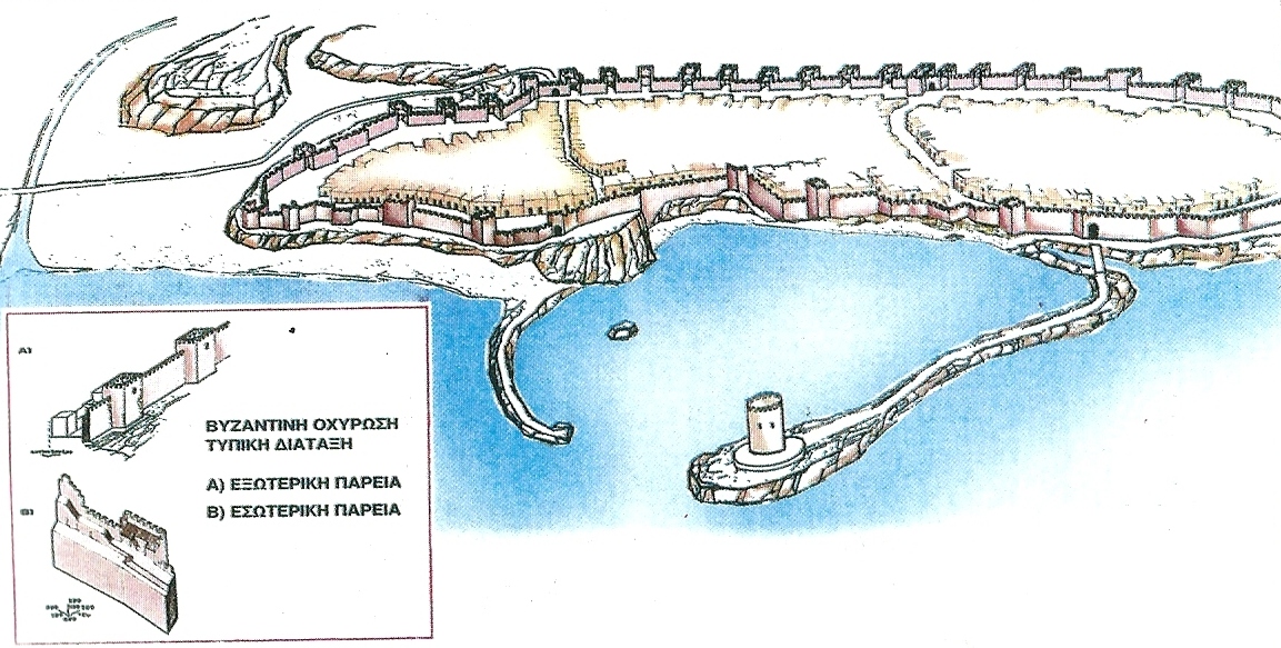 During the First Byzantine Period, a small fortified settlement known as Kastro stood near the harbour. Remains of its early Byzantine fortifications have been discovered close to the port and within the historical centre of Heraklion.
Between 824 and 827, Crete was conquered by Andalusian Arab exiles led by Abu Hafs Umar, known in Byzantine sources as Apochapsis. The new rulers selected the small coastal stronghold as the capital of the Emirate of Crete. The island’s former administrative centre, Gortyn, consequently lost its central role.
The Arabs strongly fortified the new city and excavated a deep moat around it. This gave rise to the name Rabḍ al-Khandaq, meaning Castle of the Moat, which later became Chandax in Greek. The Arab walls followed approximately the line from the present Heraklion Archaeological Museum towards Daidalou and Handakos streets before reaching the sea. Chandax developed into an important port and a powerful base for the Arab fleet in the eastern Mediterranean.
The Byzantines launched several unsuccessful campaigns to recover Crete. In 960, a major expedition was organised under the general Nikephoros Phokas. Following a lengthy siege, Chandax was captured in March 961 and Crete was restored to the Byzantine Empire.
The fortifications suffered extensive damage during the conquest. Nikephoros Phokas attempted to establish a safer administrative centre inland, in the area of Temenos, near modern Profitis Ilias. The population gradually returned to Chandax, however, and the Byzantines repaired or rebuilt its defences over the remains of the Arab walls.
One of the main gates stood near the present Aktarika building, close to the Morosini Fountain. During Venetian rule it became known as the Voltone, or Great Arch. The Byzantines also strengthened Crete’s wider defensive network and settled soldiers and populations from different parts of the empire on the island.


The Venetian fortifications of Candia
 Following the capture of Constantinople by the Fourth Crusade in 1204, sovereignty over Crete was transferred to the Republic of Venice. Before the Venetians could establish themselves, the Genoese adventurer Enrico Pescatore occupied important positions on the island and fortified Chandax and several other strongholds. After a period of conflict with the Genoese, Venice effectively established its rule in 1211.
The Venetians called the city Candia and made it the capital of the Regno di Candia, the Kingdom of Crete. At first they repaired and adapted the earlier Byzantine walls, which enclosed a relatively small area around the harbour. The medieval wall began near present-day Bentenaki, followed approximately the modern streets of Handakos and Daidalou and returned to the port.
Numerous uprisings challenged Venetian rule during its first centuries. Among the most important were the revolt of Alexios Kallergis between 1282 and 1299 and the Revolt of Saint Titus between 1363 and 1366. The latter was initiated by Venetian feudal lords on Crete and supported by part of the local population, but was eventually suppressed by Venice.
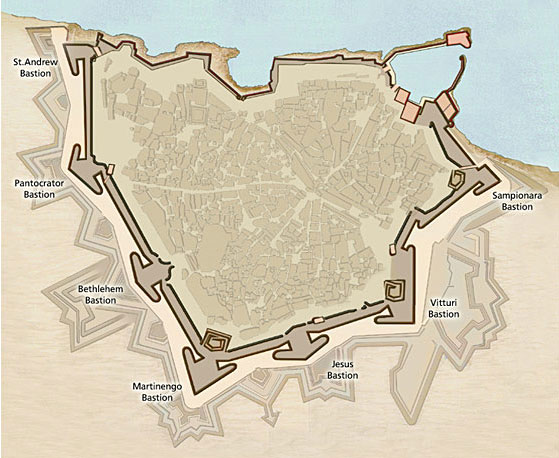
The spread of gunpowder and artillery, the continuous growth of the suburbs and the increasing Ottoman threat made a new defensive enclosure necessary. Work on the new walls began in 1462 and continued for more than a century, with improvements still being made during the Ottoman siege. Several important Venetian military engineers contributed to their design, including Michele Sanmicheli.
Thousands of Cretans worked on the fortifications, often through compulsory unpaid labour, while construction materials were brought from local quarries and ancient ruins. The new enclosure was approximately triangular, with its base facing the sea, and surrounded both the old city and much of its suburbs. Its landward section extends for more than four kilometres and was protected by a wide moat, outer defensive works and detached forts.


The bastions
The landward walls were strengthened by seven large bastions. These low, broad structures were designed for the use of artillery and allowed the defenders to cover both the ground in front of the walls and the neighbouring sections of the fortifications.
- At the northeastern end stood the Sabbionara or Sand Bastion, together with the Zane cavalier.
- Further south, near the present Kapetanakio School, stands the Vitturi Bastion.
- Beside the Jesus Gate, today’s Kenourgia Porta, stood the Jesus Bastion.
- At the southern apex of the enclosure is the Martinengo Bastion, the largest of the seven and the site of the tomb of Nikos Kazantzakis.
- To the southwest lies the Bethlehem Bastion, near Kommeno Benteni.
- Beside the Pantokrator Gate or Chanioporta stands the Pantokrator Bastion.
- At the northwestern end of the landward defences lies the Saint Andrew Bastion, one of the most vulnerable points during the Ottoman siege.
Vaulted galleries, gunpowder magazines, barracks and other military facilities were constructed within the walls and behind the bastions. At the entrance to the harbour, the Venetians replaced an earlier fortress with the new Rocca a Mare, the present Koules Fortress. Completed during the first half of the 16th century, it still dominates the Venetian harbour.
The siege and the Ottoman period
The Ottoman campaign to conquer Crete began in 1645. By 1648, Ottoman forces controlled most of the island and commenced the systematic siege of Candia. The city resisted from May 1648 until September 1669, making it one of the longest sieges in recorded history.
The fiercest assaults concentrated on the Saint Andrew and Sabbionara bastions. The Venetian-Cretan engineer Andrea Barozzi was accused of revealing weak points in the defences to the Ottomans, although it is uncertain whether his actions played a decisive role in the city’s fall. Following enormous losses and the exhaustion of the defenders, the commander Francesco Morosini negotiated the surrender of Candia in September 1669.
The Ottomans repaired and reused the Venetian fortifications, adapting them to their own military requirements. They also gave Turkish names to several monuments: the Jesus Gate became Yeni Kapı, meaning New Gate, Dermatas Gate became Kum Kapısı, while Rocca a Mare gradually became known as Koules.
During the long Ottoman period, the walls were repaired or neglected according to military needs. Today the Venetian Walls of Heraklion, together with Koules Fortress, the gates, galleries and moat, form one of the most important and best-preserved Renaissance defensive complexes in the Mediterranean.


