


Tavri Plateau
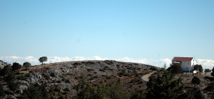
The plateaus of Tavri and Niatos are located 2km and 3km west of Askifou Plateau, 51km south of Chania, at an altitude of 1200m. They can be accessed via a road starting from Askifou, crossing Tavri and then ending up in Niato.

Planes of History
Cretan history is highly related to its fertile plateaus
that fed generations of rebels.
The entire prefecture of Lassithi took
its name after the homonym plateau.
Lassithi | Nida | Omalos | Askyfou | Messara Plane




Crete's mountainous and karst landscape has created numerous large and small plateaus between its mountain ranges. Many are enclosed basins where water from the surrounding mountains collects before draining through sinkholes and underground channels. Sediments accumulated over time to form fertile soils, and many plateaus have been used for centuries for cultivation, livestock farming and seasonal settlement.
The largest plateau in Crete is the Lassithi Plateau, at an average altitude of about 850 metres, surrounded by the peaks of the Dikti Range. Its fertile land is extensively cultivated. The characteristic wind-powered water pumps on the plain and the old stone flour mills at its approaches are important elements of its agricultural history. Other plateaus in the same mountain range include Katharo, Limnakaro, Nissimos, Lapathos, Erganos and the Omalos Plateau near Viannos.
In the Psiloritis Range, the Nida Plateau stands out at an altitude of about 1,400 metres. The area is closely associated with pastoral traditions, stone shepherds' huts known as mitata and the Idaean Cave, one of ancient Crete's most important sacred caves. The smaller Stroumboulas Plateau lies among the eastern foothills of the range. In the White Mountains lies the Omalos Plateau, whose edge at Xyloskalo marks the start of the descent into the Samaria Gorge. Other plateaus include Askyfou, Tavri, Niatos and the smaller plateaus around Anopolis.
Fertile plains also extend between the mountains and near the coast. The largest is the Messara Plain in southern Crete, between Psiloritis and the Asterousia Mountains. Crossed by the Geropotamos River, it has been one of the island's most important agricultural areas since antiquity, as illustrated by the archaeological sites of Phaistos and Gortyn. Important cultivated areas also extend around Ierapetra, Kastelli Pediada and the coastal zones of Chania and Rethymnon.
Crete's plateaus and plains are closely connected with agricultural production, livestock farming, local architecture and traditional water management. They form landscapes of considerable natural and cultural value, where the close relationship between local communities and their environment remains visible.


 Beaches
 Nature
 Past
 Destinations
 Highlights
 West CreteCentral CreteEast CreteChaniaPaleochoraKissamosGeorgioupolisChora SfakionLoutroRethymnonAgia GaliniPlakiasSpiliAnogiaHeraklionHersonissosMaliaMatalaAgia Pelagia`ArchanesKokkinos PirgosAgios NikolaosEloundaSitiaIerapetraMakrigialosPalekastroZakrosLassithi Plateau


