")


The plain of Messara is located on the south side of Heraklion Prefecture, in an elongated area of 50km in length and with its width not exceeding 7km. In the south, the valley is protected by the wild Asterousia Mountains, while its western side is bounded by a vast beachfront with sandy beaches.

The cave of Agia Fotini is on located on Mount Louloudaki, 7km south of Avdou village, at an altitude of 760m. 35km east of Heraklion is the Avdou village, where a sign "Agia Fotini Cave - 7 km”, shows the direction. From there you enter a dirt road, which leads to a small square below the mouth of the cave. Following the steep path on foot, the visitor arrives at the entrance of the cave.

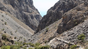
Kallikratis is a relatively small gorge in the southeast region of Lefka Ori (White Mountains) in Chania Prefecture. The gorge connects the mountainous pasture lands with the lowland villages. It is a very pleasant walk, offering great views and rare flowers, but is not very popular with tourists. The Kallikratis Gorge together with the Asfendou Gorge can be a full day’s excursion.

Kladissos is located 21km northwest of Crete, west of the resort of Agia Pelagia. The beach is situated in front of the largest hotel of the region that spans the entire area of the Cape of Souda.

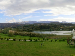
The artificial lake of Agia (Ayia) is located near the village of Agia, 9 km west of Chania. It is a small lake of 450 acres, which is close to the valley of Fasas. This valley is considered as the most humid of Crete. Agia lake receives water from underground springs and the river Xekolomenos.
It is located at the exit of a small valley, a rare phenomenon in the wild Asterousia Mountains, which starts from the village Antiskari and ends in settlement. The fertile valley is used for growing early vegetables such as tomatoes, cucumbers, peppers, etc., since the temperature here is always high. Characteristic of the warm climate is that the swallows do not leave the area in winter.

Votsalaki (or Botzalaki) is located 71km southeast of Agios Nikolaos and 36km east of Ierapetra, on the west end of Goudouras, at the position of Aspra Chomata (White Soil). It is situated amid the arid and rugged landscape of East Crete, close to the exit of the wild Gorge Asprolithos.
Pourgonero beach is located at Krassas area, just 500m east of the port of Tsoutsouras, in the area where the houses of the settlement stop. It is actually the eastern part of Tsoutsouras bay, located in front of the hill Sarakinos. According to the legend, the eternal sarcophagus of King Minos, the mythical king of Crete, is burried below this place.
Also read:

- Home
 Beaches
 Nature
 Past
Past Destinations
 Highlights
 West Crete
- Central Crete
- East Crete
- Towns
- Chania Prefecture
- Chania
- Paleochora
- Kissamos
- Georgioupolis
- Chora Sfakion
- Loutro
- Rethymnon Prefecture
- Rethymnon
- Agia Galini
- Plakias
- Spili
- Anogia
- Heraklion Prefecture
- Heraklion
- Hersonissos
- Malia
- Matala
- Agia Pelagia`
- Archanes
- Kokkinos Pirgos
- Lassithi Prefecture
- Agios Nikolaos
- Elounda
- Sitia
- Ierapetra
- Makrigialos
- Palekastro
- Zakros
- Lassithi Plateau
- Get Prepared


