








 Samaria Gorge

Samaria Gorge is one of the longest and most famous hiking gorges in Europe and forms part of the European E4 hiking trail. Thousands of visitors cross it every year, and for many it is one of the main reasons for visiting Crete. The complete route from Xyloskalo on the Omalos Plateau to Agia Roumeli is approximately 14.5 km long and usually takes 5-7 hours, depending on pace and stops.
 The initial descent from Xyloskalo to the riverbed The gorge lies in the southern part of Chania Prefecture and was carved by the river flowing between the main massif of the White Mountains (Lefka Ori) and Mount Volakias. Several lateral gorges join Samaria; many are technical routes that require ropes and canyoning equipment. One of them, Perdika, features a waterfall approximately 240 m high.
 Drinking water is available from springs along the route The section through Samaria National Park, from Xyloskalo to the exit near Old Agia Roumeli, is approximately 13 km long. From there, hikers continue for another 1.5 km to reach the present village and beach of Agia Roumeli, bringing the complete route to about 14.5 km.
 Saint Nicholas chapel The most famous part of the gorge is the stretch known as the Iron Gates (Sideroportes), where the sides of the gorge close in to a width of only four meters and soar up to a height of 500 m. The gorge became a national park in 1962, particularly as a refuge for the rare Cretan ibex, which is today restricted to the Lefka Ori National Park, the island Thodorou and several more islets. There are several endemic species of fauna and flora in the gorge and surrounding area.
Samaria Gorge was designated a UNESCO Biosphere Reserve in 1981, in recognition of the area’s exceptional biodiversity, distinctive geomorphology and considerable ecological value. Samaria National Park has also been included on Greece’s Tentative List for possible future inscription on the UNESCO World Heritage List since 2014. Inclusion on the Tentative List is a preliminary stage and does not mean that Samaria is already a World Heritage Site.
 The Cretan ibex, the gorge's best-known resident The now-abandoned village of Samaria lies inside the gorge. Its last residents left in 1962, when the National Park was established. The most widely accepted explanation links the names of the village and gorge to the old church of Saint Mary of Egypt (Osia Maria).
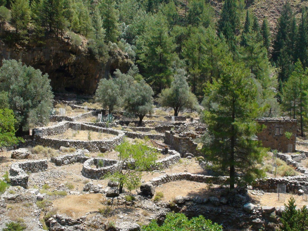 The abandoned village of Samaria A "must" for visitors to Crete is to complete the walk down the gorge from the Omalos plateau to Agia Roumeli on the South Cretan Sea. From there the most visitors get the ferry to the port of Chora Sfakion and catch a coach back to Chania. The walk takes 4-7 hours and can be strenuous, especially at the peak of summer.
When to come
Tickets and operation: An entrance ticket is required for the National Park and can be issued through the official NECCA ticket platform. The opening period and daily admission hours are determined by the competent authorities each year. Access may be modified or temporarily suspended because of extreme weather, high fire risk, seismic activity or other safety concerns. Always check the official platform for the latest notice before travelling to the gorge.
 Hiking through the gorge Samaria is one of Crete's most popular natural attractions and can become crowded during peak periods. Starting early, before most organised groups arrive, usually makes the walk more enjoyable. Staying overnight at Omalos makes an early start easier, while a later departure may require an overnight stay in Agia Roumeli. In every case, walkers must allow enough time to complete the route within the permitted entry and exit hours and, if leaving the same day, to catch the final ferry.
 Donkeys are used for emergency transport in the gorge Spring is generally the most rewarding time to walk through the gorge, as temperatures are milder, vegetation is at its best and water is more abundant. The route can be particularly demanding during a summer heatwave, so visitors should take the weather forecast and official safety notices seriously.
 Rock formations along the route Many travel agencies in Crete organise excursions to the gorge, usually including transport to Xyloskalo and collection after the ferry reaches Chora Sfakion. Independent visitors can travel by bus to Omalos and return by ferry from Agia Roumeli towards Chora Sfakion, Sougia or Paleochora. Bus and ferry schedules vary by season and should always be confirmed in advance.
A shorter alternative is to enter from Agia Roumeli, walk upstream to the Iron Gates and return by the same route. This provides a glimpse of the lower gorge but is not equivalent to the complete crossing.
The course from Xyloskalo
 Sideroportes (Iron Gates) The descent begins at Xyloskalo on the Omalos Plateau, at an altitude of approximately 1,250 m, where the northern entrance to the National Park is located. Admission is ticketed, and visitors are advised to issue their ticket in advance through the official NECCA platform. The clearly marked trail initially descends steeply through a forest of cypress and pine trees. Drinking-water fountains, rest areas and toilets are available at several points along the route.
One of the most pleasant stops along the route is Agios Nikolaos, located about halfway through the gorge. The area features the historic church of Agios Nikolaos, the old forest ranger station and the remains of an ancient open-air sanctuary dedicated to Apollo and Artemis, reflecting the long history of human activity in the gorge.
In about three hours we reach the old village of Samaria, at an altitude of about 300 meters. In Samaria there are old houses, trees offering shade, water springs and if you are lucky you will meet the endangered Cretan wildgoat. From here onwards the landscape changes, becomes drier and the slope gets smooth. One hour later we walk along the riverbed for some time. There are several small wooden bridges in several places, above the river.
After one more hour we meet the imposing Sideroportes (Iron Gates) which is a very narrow passage between two tall vertical 500m high cliffs. We soon reach the old village of Agia Roumeli that was abandoned in the mid 1900s due to a devastating flood and was moved to the seaside settlement of Agia Roumeli, which is about 30 minutes away.
Important: Samaria Gorge operates seasonally, but its exact opening date, closing date and admission hours are announced by the competent authorities and may differ from year to year. Even during the operating season, access can be suspended at short notice for safety reasons. Check the official NECCA ticket platform before setting out.
.jpg)


.jpg)


What is near me?
Additional Info
- Length (km): 18
- Type: Hiking gorge, Signed trail, E4 trail
- Location: Chania Prefecture
- Water: Water all year round, Springs
- Difficulty (0-10): 2
- Altitude difference (m): 1200
- Hiking Hours: 6
- Accessibility: Bus services, Paved road, Boat
- Entrance Fee (€): 5


