")


Faflagos is located 89km southeast of Iraklion, near the village Arvi. It is a small seaside settlement at the exit of a small valley, which is crossed by the river Blavaris or Blavopotamos, which has no water in summer and starts from Kato Symi. In front of the village, stretches a very long shore with beautiful and tranquil beaches. Nearby, there are many greenhouses with crops of bananas and fresh vegetables.
Arvi is a large seaside village located 79km southeast of Heraklion and 35km west of Ierapetra, in a large valley formed in front of the imposing Gorge of Arvi. It is built on the location of the homonym ancient Arvi. In the valley of Arvi and the surrounding area, there are too many greenhouses. The locals deal mainly with agriculture, because the warm climate of the region helps the production of bananas, fresh vegetables and olive oil.
Armenopetra is located 73km southeast of Heraklion and 5km east of the seaside village of Keratokambos. The beach is situated south of town Kapsali and is one of the most beautiful beaches in the region of Keratokambos. The area is quite dry, as it’s name implies (Kapsali means dry and arid).
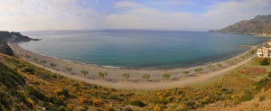
Keratokambos is a small seaside resort situated 72km southeast of Heraklion, a few miles east of Tsoutsouras and Viannos. Keratokambos, with the nearby village of Kastri, has become a new tourist destination during the last years because more and more visitors come to the area and enjoy the beautiful shores. Indeed, in front of the village of Keratokambos a vast beach, several kilometers long, stretches in both directions.
Kastri is located 72km southeast of Heraklion, in the sheltered bay of Keratokambos. It is the biggest of the two settlements of the region (the second is Keratokambos), which are now united. In recent years Kastri has faced considerable development, mainly because the surrounding beaches are a magnet for visitors.
Listis is located 69km southeast of Iraklion, between Kastri (2km western) and Tsoutsouras. The street linking Kastri and Tsoutsouras passes next to the beach. However, in order to get to the beach you should descend a steep slope. Alternatively, you can get off at the next beach of Kamboula and walk eastwards. Whichever way you choose, it definitely is worth it.
Dermatos is located 64km southeast of Heraklion and 4km east of Tsoutsouras. It is formed in a small valley on the western banks of the river Anapodaris. Traces of a Minoan settlement have been found in the area.
Pourgonero beach is located at Krassas area, just 500m east of the port of Tsoutsouras, in the area where the houses of the settlement stop. It is actually the eastern part of Tsoutsouras bay, located in front of the hill Sarakinos. According to the legend, the eternal sarcophagus of King Minos, the mythical king of Crete, is burried below this place.
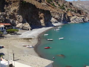
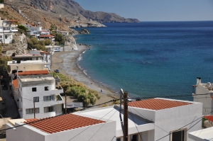
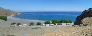
Tsoutsouras or Tsoutsouros (deriving from the Venetian word Zuzzuro) is located 63km south of Heraklion, at the exit of the imposing Gorge of Mindris. It is built on the site of the ancient city Inatos, which was the port of Priansos (located near Kasteliana village).
Maridaki is a seaside hamlet on the eastern side of Asterousia Mount, 65km south of Heraklion and in the west side of Tsoutsouras Bay. Despite the short distance from Tsoutsouras (2-3km), there is no direct road linking the two settlements (except a footpath). The only thing that separates Tsoutsouras and Maridaki is a very steep mountain with numerous caves and karstic formations.
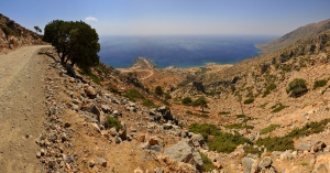
The most common way to get there is to drive in the rugged dirt road that starts from the village Ahendrias and ends at the Monastery of St. Nikitas after 15km. The fascinating route runs along steep cliffs and wild sharp rocks, a characteristic landscape of the Asterousia Mountains.
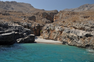
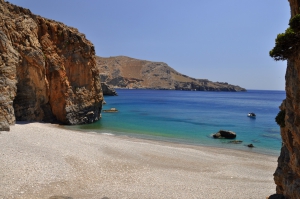
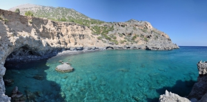
The beach, which is in one of the most isolated areas of the island, has beautiful pebbles and is surrounded by tall vertical cliffs. The beach is mainly accessed by boat, but you could also trek from Agios Nikitas. The surrounding area is ideal for fishing. Moreover, if you come by boat, do not forget to walk in the gorge and admire the rugged landscape, till the dead end with falls that get dry in summer.
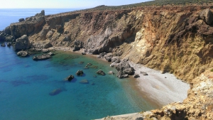
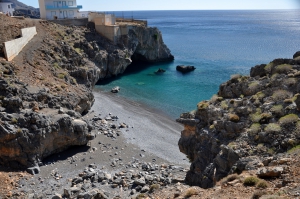
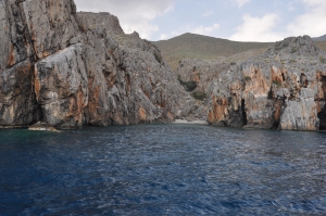
Kaminaki Beach is located 58km south of Heraklion, in the southeastern outskirts of Asterousia Mountains. The surrounding mountains form a purely Cretan landscape, with inaccessible gorges, bare rocks, steep cliffs and remote beaches accessible only on boat. The beach of Kaminaki is formed at the exit of the wild Perivoliano Gorge.
Voidomatis or Vouidomatos (i.e. ox’s eye) is located 62km south of Heraklion and 2.5km east of the hamlet Treis Ekklisies. The area is situated on the southern slopes of Asterousia Mounts. The impressive gorge of Mesosfini with towering walls and wild cliffs, a very common landscape for Asterousia, stops in Voidomatis.
Tris Ekklisies (i.e. three churches) is a secluded seaside village located 64km south of Heraklion, amid the wild and inhospitable landscape of Asterousia Mountains. The surrounding area, one of the most isolated in Crete, is difficult to access, but has some amazing beaches. To get to Treis Ekklisies you have to drive through a rough dirt road, about 10km long, from the village Paranymfi.
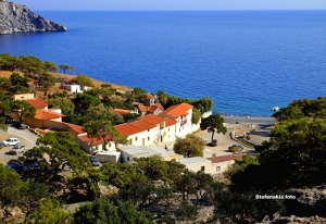
The monastery of Koudoumas is located 74km south of Heraklion, on the western side of Cape Martelos and south of Kofinas Peak (the highest peak of Asterousia Mountains). The whole area is full of cavities where hermits used to live. To reach the monastery, you have to drive in a passable dirt road of 20km, starting from the village Sternes, which descends from an altitude of 1000m to the sea level.
Agios Antonios (St. Anthony) is located 71km south of Heraklion, between the hamlet of Agios Ioannis and the Monastery of Koudoumas. The area is very isolated and can be accessed only via a footpath that connects Agios Ioannis with the monastery. The trail passes between pine trees.
Agios Ioannis (St. John) is a small coastal village located 73km south of Heraklion, south of the village Kapetaniana. Kapetaniana is very close to the highest peak of Asterousia Mountains, Kofinas Peak. In Kapetaniana, you can visit the Byzantine Church of the Panagia and the Church of the Holy Cross, or climb in the local climbing track.
Katarti is a tiny beach that is formed in the exit of a small gorge, 73km south of Heraklion city, at the base of Oxa Cape. This secluded beach is located amidst the wild and majestic landscape of Asterousia Mountains, southwest of the summit of Kofinas.
Tripiti (or Trypiti) is located 73km south of Heraklion and 12km east of Lendas, in a small plain at the exit of the gorge of Tripiti (not the homonym gorge of Sfakia area). The name is taken after the church of Panagia Tripiti, which is built inside a cave at the base of the canyon.
Also read:
- Home
 Beaches
 Nature
 Past
Past Destinations
 Highlights
 West Crete
- Central Crete
- East Crete
- Towns
- Chania Prefecture
- Chania
- Paleochora
- Kissamos
- Georgioupolis
- Chora Sfakion
- Loutro
- Rethymnon Prefecture
- Rethymnon
- Agia Galini
- Plakias
- Spili
- Anogia
- Heraklion Prefecture
- Heraklion
- Hersonissos
- Malia
- Matala
- Agia Pelagia`
- Archanes
- Kokkinos Pirgos
- Lassithi Prefecture
- Agios Nikolaos
- Elounda
- Sitia
- Ierapetra
- Makrigialos
- Palekastro
- Zakros
- Lassithi Plateau
- Get Prepared


