")


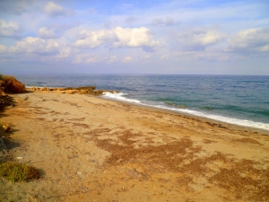
Kalivaki is the westernmost beach of Georgioupolis bay, located 38km east of Chania and 21km west of Rethymnon, near the exit of Almyros river which has water all year round lies the nice beach of Kalivaki. It is a beautiful sandy beach and water, due to the rivers is very cold.
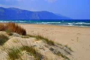
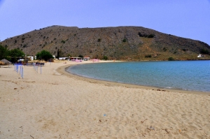
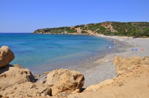
At the point where the prefecture of Rethymno meets Chania, east of Georgioupolis beaches, we find the beaches of Kavros and Kournas. The place at its greatest part is developed and only a very small part of it has been left untouched. Between this remaining virgin parts of the beach there is an extensive and very important ecosystem of dunes.
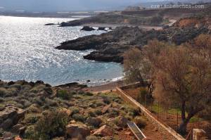
The beach of Agios Antonios (Saint Anthony) is located in a quiet bay, 2.5km east of Sougia and 68km west of Chania, in one of the most remote places on Crete. The surrounding area is called Charéi, thus you might hear many locals calling that like this.
Keratides is located about 1km west of Paleochora harbor, 79km south of Chania city, just after the exit of Azogirianos river and the beach Halikia. It has coarse pebbles and stones and is preferred by those who seek peace and avoid crowds.
“Tou Meri to Pigadi” is located 8km northwest of Kissamos and 44km west of Chania, on the eastern side of Cape Gramvousa. The name means “Meri’s well”, probably named after the name of someone, who owned a well.

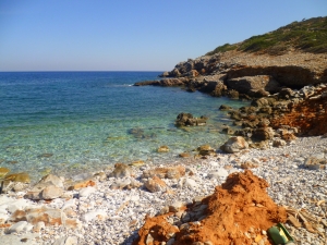
The beach has sand and fine pebbles, while in several places there are rocks, making it perfect for fishing and snorkeling. It is completely unorganized, so make sure that you have anything you need with you. There is a small taverna located in the neighboring Peristeres beach (3-5' minutes walking distance).
Pervolia, Misiria and Platanias (or Platanes) are three consecutive suburbs of Rethymnon, located 3-5km west of the city, respectively. They were separate settlements, which have been incorporated into the urban fabric of Rethymnon, due to the residential development.
Misiria get their name from the Arabic word Misr, which is a suburb of Cairo with very fertile soil. Similarly, the region is named Misiria because of the fertile land, which still produces many vegetables.
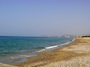
Pighianos Kampos (or Kambos) is located 8km east of Rethymno, in the middle of the vast beach of Rethymno Gulf. The name means “Plain of Pigi” in Greek, taken after the fields of the residents of Pigi village, which is located in close proximity.
At the coast between Panagia Charakiani and the hill Kefali, with the archeological findings, a bit west of Holy 318 Fathers, we meet the area of Propatoumenos. Propatoumenos means the area that can be walked, as there was a trail to the nearby ancient town of Astali, by Bali.
Almirida is a very small fishing village, located 38km east of Rethymnon, near the village of Sises. The village is not touristically developed and is mainly known to locals. On the west there is a small pier, which protects the small harbor of Almirida.

Behind the big hill west of the settlement Tris Ekklisies, there is a second stunning beach with fine sand, which is completely isolated and surrounded by the largest carob wood in Europe. The beach is called Pahia Ammos and is shaped at the exit of Agia Paraskevi Gorge, which also houses an unknown 105m high waterfall (only in winter).
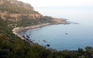
The bay of Salamia(s) is located 74km south of Heraklion, between Agios Ioannis and Tripiti. There is no road nearby, thus it is one of the most secluded areas of Crete. You can reach it either by boat or by easy walking from Agios Ioannis.
The very quiet beach of East Tsigounas, mostly known as Petrakis, is located 1km east of Lendas and 76km south of Heraklion. it is located on the foots of the steep and inhospitable slopes of Asterousia Mountains.
West of Platia Peramata village, there is another smaller settlement called Krigioi. In front of Krigi, there is a small cove with fine pebble and crystal clear water. Krigi beach is ideal for seclusion, snorkeling and fishing. West of Krigi, you'll reach another pebbly remote beach. Some more meters on the west you'll find the three consecutive beaches of Kokkines Plakes (i.e. Red Rocks), named after the reddish rocks around and accessed mainly through sea.
The beach of Lassea in front of the village Chrysostomos is very beautiful, with coarse sand and well protected from the west winds. It is unorganised, but still it's close to the settlement. On the west end of the beach there is a "line" of rocks, that heads towards the small islet of Trafos. This is the old dock of the ancient city Lassea.
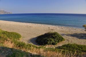
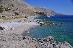
Tripiti is an untouched beautiful beach with pebbles and deep blue waters. It is surrounded by towering cliffs and on the east side there are some beautiful caves. The steep cliffs make it one of the most isolated beaches of Heraklion. There is no access by car, although you can still see the remains of the road that leaded to the beach until 1995. The road has been completely destroyed by floods and now there is not even a footpath.
At the exit of Aposelemis, a beautiful sandy beach with shallow cool waters is formed. Although it is very close to big hotels and tourist areas, the beach is not very well organized, compared to the rest beaches of the area. There are a few umbrellas and sunbeds on the beach.

To reach the beach you can walk into the small canyon, until you meet the sea. From Finokalias follow the short path that leads northwards, until you see the bed of the gorge. While walking along this, you will cross one beautiful and wild landscape with bare rocks, low vegetation and numerous spices and herbs.
Agios Antonios (Saint Anthony) is located 30km northwest of Agios Nikolaos, in the well hidden and unexplored northern shores of Mirabello area, 3km north of the village Selles. The area has several small beaches where you can go by driving north from the village Selles mainly in a passable dirt road. In the region you will not find anything else, but some cottages and farms.
Also read:
- Home
 Beaches
 Nature
 Past
Past Destinations
 Highlights
 West Crete
- Central Crete
- East Crete
- Towns
- Chania Prefecture
- Chania
- Paleochora
- Kissamos
- Georgioupolis
- Chora Sfakion
- Loutro
- Rethymnon Prefecture
- Rethymnon
- Agia Galini
- Plakias
- Spili
- Anogia
- Heraklion Prefecture
- Heraklion
- Hersonissos
- Malia
- Matala
- Agia Pelagia`
- Archanes
- Kokkinos Pirgos
- Lassithi Prefecture
- Agios Nikolaos
- Elounda
- Sitia
- Ierapetra
- Makrigialos
- Palekastro
- Zakros
- Lassithi Plateau
- Get Prepared


