")


Το φαράγγι της Κριτσάς ξεκινάει κοντά στο γραφικό χωριό της Κριτσάς, 9.5km νοτιοδυτικά του Αγίου Νικολάου και καταλήγει στο χωριό Τάπες. Έχει μήκος 13km και σε μερικά σημεία το πλάτος του φτάνει μόλις το 1.5m.

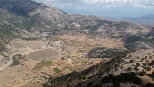
The Plateau of Askifou is located 50km south of Chania, in one of the nicest and most authentic areas of Crete. The wild mountains around and the serenity of the valley, form a magnificent landscape all year round.

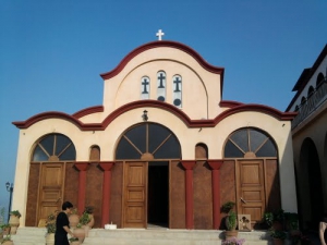
Η μονή Παναγίας Θεογεννήτορος βρίσκεται πολύ κοντά στο Μοχό Ηρακλείου και είναι κτισμένη σε τοποθεσία με μοναδικά θέα στις ακτές της Σταλίδας. Το μοναστήρι, αν και νεώτερο, έχει αποκτήσει μεγάλη φήμη κυρίως λόγω του ιδρυτή του μοναστηριού, μοναχού Απόστολου.

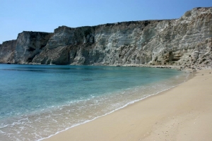
Στο Νοτιοανατολικό άκρο της Λεύκης, στη βάση του ακρωτηρίου Τραχήλι σχηματίζεται ο μαγικός αμμουδερός κόλπος της Χιλιαδερφιάς με το χαρακτηριστικό λευκό χρώμα των πετρωμάτων της περιοχής που έδωσε στην αρχαιότητα στο νησί το όνομα Λεύκη. Η Χιλιαδερφιά έχει στη δυτική της πλευρά πηγή γλυκού νερού ενώ καταλήγει σε ένα απότομο, κοφτό γκρεμό 100μ. πάνω από το ύψος της θάλασσας.

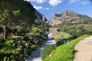
Το φαράγγι του Πετρέ βρίσκεται 13km δυτικά του Ρεθύμνου και καταλήγει στην παραλία της Επισκοπής. Ο ποταμός του φαραγγιού, ο μεγαλύτερος στο δυτικό Ρέθυμνο, τροφοδοτείται από τα νερά των Κολλητών Φαραγγιών και της τριγύρω περιοχής, καλύπτοντας το μισό νομό, έχοντας νερό όλο το χρόνο.

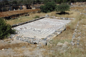
Within short distance from Elounda, near the salt pans, we meet few remains of the ancient city Olous (most inside the sea) that was inhabited since the Minoan period. Olous was one of the hundred most important cities of ancient Crete with a maximum population of over 30,000 people.

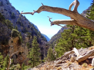
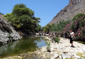
Το φαράγγι της Ελυγιάς είναι ένα μεγάλο και εντυπωσιακό φαράγγι με άγρια ομορφιά, το οποίο διέρχεται παράλληλα με το φαράγγι της Σαμαριάς. Το συνηθισμένο μονοπάτι για να το προσεγγίσετε ξεκινάει στο χωριό Άγιος Ιωάννης Σφακίων, κοντά στην Ανώπολη. Αφού το συναντήσουμε, μετά από πεζοπορία 3.5 ωρών μέσα σε καταπληκτικά τοπία, φτάνετε στην όμορφη παραλία της Σελούντας με τα πολλά πεύκα.
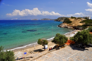
Βορειότερα από το ιστορικό ξενοδοχείο Μιραμπέλο,στα 500μ. θα συναντήσετε την ήρεμη παραλία Χαβάνια, στην οποία λειτουργεί πλήρως οργανωμένη δημοτική πλαζ. Στα Χαβάνια υπάρχουν επιλογές για διαμονή και φαγητό, ενώ στην παραλία θα βρείτε ναυαγοσώστη και θαλάσσια σπορ.


