")


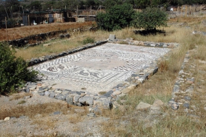
Σε μικρή απόσταση από την Ελούντα, στη περιοχή των Αλυκών, βρίσκονται ελάχιστα ερείπια της αρχαίας πόλης Ολούς (κυρίως μέσα στη θάλασσα) που κατοικήθηκε οργανωμένα από τα Μινωικά χρόνια. Η Ολούς ή Ολούντα υπήρξε μια από τις σημαντικότερες εκατό πόλεις της αρχαίας Κρήτης, με πληθυσμό άνω των 30.000 ανθρώπων.

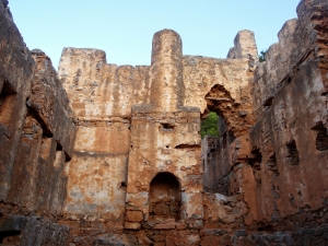
On the west side of the exit of Samaria Gorge, above the current village of Agia Roumeli, the Turks built the Koules of Agia Roumeli to suppress the rebels hiding in the gorge. This Koules is in quite good condition. There were three more towers in wider area of Agia Roumeli (in Skoteini, Aggelokambos and Sideris positions)

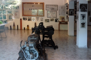
The Museum of National Resistance of 1941-1945 is located at the entrance of the village Therisso. The opening of the museum took place in May 2003 and remains open every day thanks to the voluntary offer of a lady.

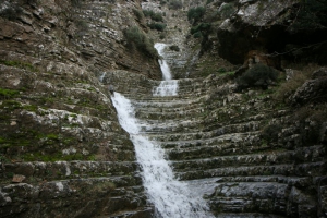
The gorge of Eligas is a monument of natural beauty located on the west side of the mountain Koupa near the village Miliaradon by Embaros. It is actually a high waterfall with nine rapels, ideal for canyoning. The difference of altitude between the entrance and the exit is about 230m.

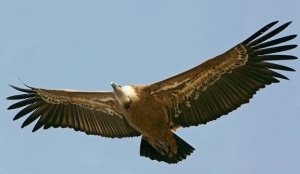
Το όρνιο (επιστ. Gyps fulvus) ή γύπας είναι ένα μεγάλο και βαρύ αρπακτικό με άνοιγμα φτερούγων 260cm και μήκος σώματος 97-104cm. Στη Κρήτη ονομάζεται σκάρα και απαντάται σχεδόν σε όλες τις περιοχές του νησιού.

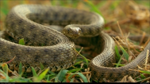
Το λιμνόφιδο (επιστ. Natrix tessellate) ή κυβόφιδο είναι ένα υδρόφιλο είδος φιδιού, το οποίο απαντάται συχνά στους μόνιμους υδροβιότοπους της Κρήτης. Πολλοί το ονομάζουν νερόφιδο, ωστόσο αυτό το όνομα ανήκει στο συγγενικό είδος Natrix natrix, το οποίο δεν απαντάται στο νησί. Τέλος, υπάρχει η υποψία ότι το λιμνόφιδο της Κρήτης ανήκει σε ξεχωριστό είδος, αλλά δεν έχει επιβεβαιωθεί ακόμη.

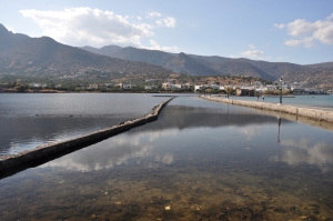
On the road that connects Elounda with Kolokitha peninsula, on the site of the ancient city Olous, we meet the Venetian salt pans that functioned until 1972. We see dozens of cisterns separated by walls in the shallow sea, where water from the lagoon of Elounda was trapped early spring and evaporated till September.

The route starts from Spili, reaches the spring of Agia Fotia, and then ascends to Kissos. It comes above the Monastery of the Holy Spirit and climbs to the summit of Mount Kedros (1776 m.). From there we go back and meet the trail that leads to the Church of the Prophet Elijah and descends to Gerakari. This route is a part of the European E4 trail.


